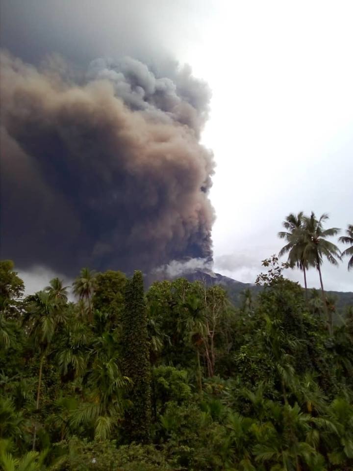
January 25 , 2019. EN. Papua New Guinea : Manam , Chile : Villarica , Colombia : Cerro Machin , Kamchatka : Sheveluch .

January 25 ,  2019.


Papua New Guinea , Manam :

An eruption of the Manam volcano sent ash into the air for nearby communities in Papua New Guinea on Wednesday, Jan. 23.
The eruption occurred just before 4 p.m. local time, sending lava down the side of the cliffs and spewing ash into the air.
According to the United States Geological Survey, an earthquake was observed just northeast of the volcano approximately two hours before the start of the volcanic eruption.
Communication to the island was cut Wednesday night, when the only Digicel tower was toppled by volcanic activity, the Manam Resettlement Authority reported.
« While authorities are issuing ash plume warnings for aviation purposes, ashfall will be generally limited outside of thunderstorms, » according to AccuWeather Meteorologist and Air Quality blogger Faith Eherts.
As is usual for this time of year in the South Pacific, summertime thunderstorms could present more issues for the region.


« Thunderstorms could initially blow ash out of the area, but it also provides an opportunity for ash to get pushed to the surface both on gusty winds and in the form of acid rain, » Eherts added.
Residents who have not already evacuated should be sure to seek shelter indoors during any stormy weather and heed the warnings of local officials.
The community experienced a sudden eruption of Manam back in August 2018, where lava forced the evacuation of 2,000 people from Manam Island, according to NASA. This began a more disruptive period for the Manam volcano.
Most of the island’s 9,000 inhabitants were evacuated back in 2004 following a major eruption.

VAAC Darwin: ash plume at a height of 12.2 km at 4:49 UTC, Aviation Color Code: RED.


MANAM ERUPTS – URGENT GOVERNMENT HELP NEEDED

Manam erupts continuously for 24 hours now as of 1 pm yesterday (unlike only 2 hours in the past). Very high temperatures. Digicel tower destroyed. People may perish next 48 hours if no help goes through.
Chairman of Manam Disaster Working Committee and Ward Member for Baliau just called. Water sources & food gardens completely destroyed.
Urgently need a temporary shelter on mainland. Need MV Godawan or transport for evacuation.
The people of Baliau (2257) and Dugulaba (862) were sent back to the volcano by a Government decision. They have no where else to go atm.

Sources : accuweather.com , Kessy Sawang.

Photos : Facebook / Kessy Sawang.


Chile , Villarica :

Villarrica Volcano-23/24 January 2019-Preliminary.

After almost 3 weeks of relatively calm and vigorous fumaroles, the lava springs and Strombolian explosions come back. As the explosions are not very frequent, they reach ballistic heights exceeding a 10-storey building, as shown in the image captured this Morning.


A recognition of the crater at noon reveals pyroclasts, lapilli and bombs up to 15 cm in size, scattered around the crater.
In the afternoon of yesterday (23), the sulphurous gases of the volcano extended about 40 km to the northeast, at an altitude of about 3,000. At around 10 pm there was a marked decrease in the vigor of fumaroles and the beginning of Strombolian activity at 22:41.


Summary of the last 7 months:
As shown by the photo-interpretation of ESA images, at the end of July 2018, the lava pit had reached the largest heat zone of the last 2 years. Subsequently, the lava pit shows a new subsidence and resurfaced in late August 2018. On November 6 and 16, 2018, it expels ballistic projectiles with impact on the perimeter of the crater. As of 24 December, the predominant frequency of tremors (the frequency with which the volcano naturally vibrates) has fallen below 1 oscillation per second, which has been maintained so far (24 January 2019). On January 3, 2019, new Strombolian explosions are observed, which deposit pyroclasts on the edges of the crater.

Source : Werner Keller / POVI.

Photos : POVI , Miguel Angel Albornoz.


Colombia , Cerro Machin :

Weekly activity bulletin of the Cerro Machín volcano
The level of activity continues at the level: Yellow activity level or (III): changes in the behavior of volcanic activity.

With regard to monitoring the activity of the Cerro Machín volcano, the COLOMBIAN GEOLOGICAL SERVICE informs that:

Over the past week, the Cerro Machín volcano has continued recording the seismic activity associated with rock fracturing in the volcanic building. This seismicity showed similar levels both in number of earthquakes and in released energy, compared to the previous week. The earthquakes were located mainly south, southeast and southwest of the main dome at depths between 2.2 and 18 km.

The highest magnitude recorded was 0.6 ML (local magnitude) corresponding to the earthquake on January 20 at 09:03 (local time), located 0.6 km southwest of the main dome, 3.9 km from depth. The other monitoring parameters used for the full assessment of volcanic activity did not show any significant changes during the past week.

The COLOMBIAN GEOLOGICAL SERVICE is attentive to the evolution of the volcanic phenomenon and will continue to inform in a timely manner of any changes that may occur.

Source : SGC.

Photo : Nestoriman.


Kamchatka , Sheveluch :

VOLCANO OBSERVATORY NOTICE FOR AVIATION (VONA).

Issued: January 24 , 2019 
Volcano:Sheveluch (CAVW #300270)
Current aviation colour code:ORANGE
Previous aviation colour code:orange
Source:KVERT
Notice Number:2019-29
Volcano Location:N 56 deg 38 min E 161 deg 18 min
Area:Kamchatka, Russia
Summit Elevation:10768.24 ft (3283 m), the dome elevation ~8200 ft (2500 m)


Volcanic Activity Summary:
A growth of the lava dome continues (a viscous lava blocks extrude out on the northern part of it), a strong fumarolic activity and an incandescence of the dome blocks and hot avalanches accompanies this process. According to video data, an ash plume on the height 4.0 km a.s.l. continues to drift to the south-west from the volcano.
Explosive-extrusive eruption of the volcano continues. Ash explosions up to 32,800-49,200 ft (10-15 km) a.s.l. could occur at any time. Ongoing activity could affect international and low-flying aircraft.

Volcanic cloud height:
13120 ft (4000 m) AMSL Time and method of ash plume/cloud height determination: 20190124/2345Z – Video data
Other volcanic cloud information:
Distance of ash plume/cloud of the volcano: 47 mi (75 km)
Direction of drift of ash plume/cloud of the volcano: SW / azimuth 230 deg
Time and method of ash plume/cloud determination: 20190124/2340Z – Himawari-8

Source : Kvert.

Photo :  Yu  Demyanchuck , Volkstat ru.

25 Janvier 2019. FR. Papouasie Nouvelle Guinée : Manam , Chili : Villarica , Colombie : Cerro Machin , Kamchatka : Sheveluch .

25 Janvier 2019.


Papouasie Nouvelle Guinée , Manam :

Une éruption du volcan Manam a envoyé des cendres dans les airs sur les communautés voisines de Papouasie-Nouvelle-Guinée le mercredi 23 janvier.
L’éruption s’est produite juste avant 16 heures heure locale, émettant de la lave le long des falaises et des cendres .
Selon le United States Geological Survey, un tremblement de terre a été observé juste au Nord-Est du volcan environ deux heures avant le début de l’éruption volcanique.
La communication avec l’île a été coupée mercredi soir, lorsque la seule tour Digicel a été renversée par l’activité volcanique, a rapporté l’Autorité de réinstallation de Manam.

« Alors que les autorités émettent des avertissements sur les panache de cendres à des fins aéronautiques, les chutes de cendres seront généralement limitées en dehors des orages », a déclaré Faith Eherts, une météorologue et spécialiste de la qualité de l’air pour AccuWeather.
Comme d’habitude pour cette période de l’année dans le Pacifique Sud, les orages d’été pourraient poser plus de problèmes pour la région.


« Les orages pourraient initialement projeter des cendres hors de la zone, mais cela fournit également une opportunité pour que les cendres soient plaquées à la surface à la fois par les vents soufflant en rafales et sous la forme de pluies acides », a ajouté Eherts.
Les résidents qui n’ont pas encore été évacués doivent s’assurer de chercher un abri à l’intérieur par tout temps orageux et tenir compte des avertissements des responsables locaux.
La communauté a connu une éruption soudaine sur Manam en août 2018, où la lave a forcé l’évacuation de 2 000 personnes de l’île de Manam, selon la NASA. Cela a été le début d’ une période plus perturbée pour le volcan Manam.
La plupart des 9 000 habitants de l’île ont été évacués en 2004 à la suite d’une éruption majeure.

VAAC Darwin : panache de cendres à une hauteur de 12,2 km à 4h49 UTC, Code Couleur aviation : ROUGE.


LE VOLCAN DE MANAM EN ERUPTION – LE GOUVERNEMENT DEMANDE UNE AIDE NÉCESSAIRE

Manam est en éruption continue depuis 24 heures à compter de 13 heures hier (contrairement à 2 heures auparavant). Très hautes températures. La Tour de communication Digicel est détruite. Les gens risquent de périr dans les prochaines 48 heures si aucune aide n’est apportée.
Le président du comité de travail sur les catastrophes de Manam et le membre du district de Baliau viennent d’appeler. Les sources d’eau et les jardins alimentaires sont complètement détruits.
Besoin urgent d’un abri temporaire sur le continent. Besoin du MV Godawan ou d’un transport pour l’évacuation.
Les populations de Baliau (2257) et de Dugulaba (862) ont été renvoyées sur le volcan par décision du gouvernement. Ils n’ont nulle part ailleurs où aller.

Sources : accuweather.com , Kessy Sawang.

Photos : Facebook / Kessy Sawang.


Chili , Villarica :

Volcan Villarrica-23/24 janvier 2019-Préliminaire

Après presque 3 semaines de fumerolles relativement calmes et vigoureuses, les sources de laves et les explosions stromboliennes reviennent. Comme les explosions ne sont pas très fréquentes, elles atteignent des hauteurs balistiques dépassant un bâtiment de 10 étages, comme le montre l’image capturée ce matin.

Une reconnaissance du cratère faite à midi révèle des pyroclastes, des lapilli et des bombes d’une taille pouvant atteindre 15 cm, dispersés dans les environs du cratère.
Dans l’après-midi d’hier (23), les gaz sulfureux du volcan s’étendaient sur environ 40 km vers le Nord-Est, à une altitude d’environ 3 000  . Aux environs de 22 heures, nous avons enregistré une diminution marquée de la vigueur des fumerolles et le début de l’activité strombolienne à 22h41.


Résumé des 7 derniers mois:
Comme le montre la photo-interprétation d’images ESA, à la fin du mois de juillet 2018, la fosse de lave avait atteint la plus grande zone de chaleur des 2 dernières années. Par la suite, la fosse de lave montre un nouvel affaissement et a resurgit fin août 2018. Les 6 et 16 novembre 2018, elle expulse des projectiles balistiques avec impact sur le périmètre du cratère. À partir du 24 décembre, la fréquence prédominante des tremors (la fréquence à laquelle le volcan vibre naturellement) est tombée en dessous de 1 oscillation par seconde, ce qui est maintenu jusqu’à présent (24 janvier 2019). Le 3 janvier 2019, de nouvelles explosions stromboliennes sont observées, qui déposent des pyroclastes sur les bords du cratère.

Source : Werner Keller / POVI.

Photos : POVI , Miguel Angel Albornoz.


Colombie , Cerro Machin :

Bulletin hebdomadaire d’activité du volcan Cerro Machín
Le niveau d’activité continue au niveau : Niveau d’activité jaune ou (III): changements dans le comportement de l’activité volcanique.

En ce qui concerne la surveillance de l’activité du volcan Cerro Machín, le SERVICE GÉOLOGIQUE COLOMBIEN informe que:

Au cours de la semaine écoulée, le volcan Cerro Machín a continué à enregistrer l’activité sismique associée à la fracturation de roches dans le bâtiment volcanique. Cette sismicité a montré des niveaux similaires à la fois en nombre de séismes et en énergie libérée, par rapport à la semaine précédente. Les séismes ont été localisés principalement au Sud, au Sud-Est et au Sud-Ouest du dôme principal, à des profondeurs comprises entre 2,2 et 18 km.

La magnitude la plus élevée enregistrée était de 0,6 ML (magnitude locale) correspondant au séisme survenu le 20 janvier à 09h03 (heure locale), situé à 0,6 km au Sud-Ouest du dôme principal, à 3,9 km de profondeur. Les autres paramètres de surveillance utilisés pour l’évaluation intégrale de l’activité volcanique n’ont pas enregistré de changements significatifs au cours de la semaine écoulée.

Le SERVICE GÉOLOGIQUE COLOMBIEN est attentif à l’évolution du phénomène volcanique et continuera d’informer en temps utile des changements qui pourraient survenir.

Source : SGC.

Photo : Nestoriman.


Kamchatka , Sheveluch :

AVIS D’OBSERVATION DU VOLCAN POUR L’AVIATION (VONA).

Émis: 24 Janvier 2019 
Volcan: Sheveluch (CAVW # 300270)
Code couleur actuel de l’aviation: ORANGE
Code  couleur de l’aviation précédent: orange
Source: KVERT
Numéro de l’avis: 2019-29
Localisation du volcan: N 56 ° C 38 min E 161 ° C 18 min
Région : Kamtchatka, Russie
Altitude du sommet: 3283 m (10768,24 pi), élévation du dôme ~ 2500 m (8200 pi).


Résumé de l’activité volcanique:
La croissance du dôme de lave se poursuit (une lave visqueuse s’épanche sur sa partie Nord), une forte activité fumerolienne , une incandescence des blocs du dôme et des avalanches chaudes accompagnent ce processus. Selon les données vidéo, un panache de cendres sur une hauteur de 4,0 km  continue de dériver vers le Sud-Ouest du volcan.
L’éruption explosive-extrusive du volcan continue. Des explosions de cendres jusqu’à 32-1500-49.200 ft (10-15 km) d’altitude pourraient se produire à tout moment. Les activités en cours pourraient affecter les aéronefs internationaux volant à basse altitude.

Hauteur du nuage volcanique:
AMSL 13120 ft (4000 m) Heure et méthode de détermination de la hauteur du panache de cendres / du nuage: 20190124 / 2345Z – Données vidéo
Autres informations sur les nuages ​​volcaniques:
Distance du panache de cendres / nuage du volcan: 75 km (75 km)
Direction de la dérive du panache de cendres / du nuage du volcan: SW / azimut 230 °
Temps et méthode de détermination du panache de cendres / du nuage: 20190124 / 2340Z – Himawari-8.

Source : Kvert.

Photo :  Yu  Demyanchuck , Volkstat ru.