January 4 , 2019. EN. Indonesia : Anak Krakatau , Colombia : Nevado del Huila , El Salvador : San Miguel ( Chaparrastique ) , Chile : Villarica , Mexico : Popocatepetl .

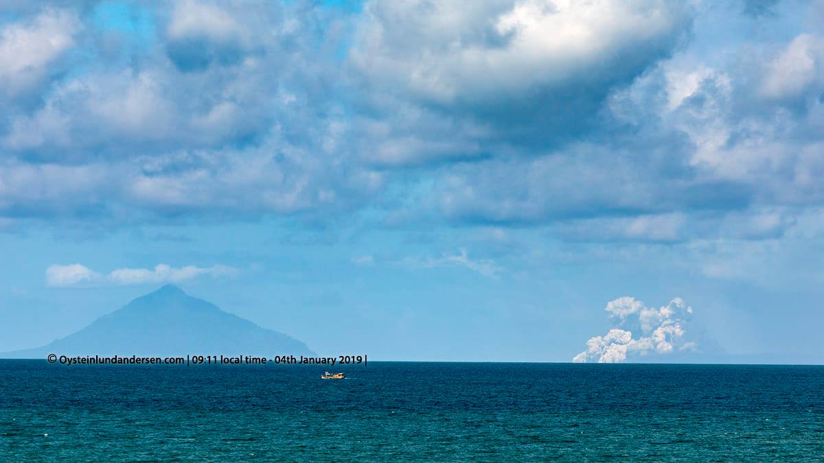
January 4 , 2019.


Indonesia , Anak Krakatau :

Eruption of Mount Anak Krakatau, Lampung, on 3 January 2019 at 12:03, with a height of ash column observed at ± 1,600 m above the summit (± 1,710 m above sea level) . The column of ash was black and thick in intensity, inclined to the north and north-east. This eruption is recorded on a seismogram of maximum amplitude of 31 mm and a duration of ± 1 minute 10 seconds. At present, the Anak Krakatau is at level III (SIAGA) with recommendations: people / tourists are not allowed to approach within a radius of 5 km around the crater

Anak Krakatau – 02.01.2019 – photo Planet Labs Inc. via BBC.


VOLCANO OBSERVATORY NOTICE FOR AVIATION – VONA.

Issued: January 04 , 2019 
Volcano: Anak Krakatau (262000)
Current Aviation Colour Code: ORANGE
Previous Aviation Colour Code: orange
Source: Anak Krakatau Volcano Observatory
Notice Number: 2019KRA05
Volcano Location: S 06 deg 06 min 07 sec E 105 deg 25 min 23 sec
Area: Lampung, Indonesia
Summit Elevation: 352 FT (110 M)

Volcanic Activity Summary:
Eruption with volcanic ash cloud at 05h30 UTC (12h30 local). Eruption and ash emission is continuing.

Volcanic Cloud Height:
Best estimate of ash-cloud top is around 5152 FT (1610 M) above sea level, may be higher than what can be observed clearly. Source of height data: ground observer.

Other Volcanic Cloud Information:
Ash-cloud moving to north-northeast.

Remarks:
Eruption recorded on seismogram with maximum amplitude 21 mm and maximum duration 161 second.

Source : PVMBG , Magma Indonésia.

Photos : Planet Labs Inc. via BBC. Øystein Lund Andersen.


Colombia , Nevado del Huila :

Weekly activity bulletin of Nevado del Huila
The level of activity of the volcano continues at the level: yellow activity level or (III): changes in the behavior of volcanic activity.

Based on the analysis and evaluation of the information obtained through the monitoring network of the Nevado del Huila volcano, from 25 to 31 December 2018, the COLOMBIAN GEOLOGICAL SERVICE – Volayan Volatological and Seismological Observatory states that:

• During the evaluated period, 101 seismic events were recorded, 45 related to rock fracturing processes (type VT) and 56 related to fluid dynamics in volcanic canals. Of these, 51 were classified as long period events (LP type), two (2) as hybrids (HB type) and three (3) as low energy tremor pulses (TR type).

• The images obtained during the week by the web cameras of Caloto, Tafxnú, Maravillas and La Palma showed a weak degassing of the volcanic system.
• Sensors for monitoring soil deformation, magnetic fields, and infrasound did not record any variations associated with changes in volcanic activity.

Therefore, it is concluded that the volcano exhibited stable behavior during the evaluated period. The Colombian geological service is attentive to the evolution of the volcanic phenomenon and will inform in due time any changes that may occur.

Source : SGC


El Salvador , San Miguel ( Chaparrastique ) : 

Special Report 3. The fumarole activity continues on the Chaparrastic volcano and emissions of fine materials are reported.

The degassing of the crater of the Chaparrastique volcano persists (figure 1), associated with the processes of pressurization of the gases of the volcanic system. Small changes in the amplitude of the seismic signal result in the emission of fine particles of ash.

Members of the local observers network (ROL) in the region reported this morning an increase in the degassing of the volcano and a drop of fine material in Conacastal Township, located northwest of the crater. There is no report of damage to people.

Figure 1. Degassing of the volcano in the southwest direction. Local observers reported a fall of fine material in the area of Conacastal Township 3.5 km northwest of the crater.

The recording of the seismic signal at the stations of San Miguel Volcano (VSM) and Ranchito shows changes in the shape and amplitude of the trace from 19:00, Tuesday 2 January 2019.
At 8:00 am on January 3, it was suddenly observed that the seismic amplitude in the VSM station is decreasing, while it is increasing in the Ranchito station. At this time, the local observers network reports the fall of fine materials in the region. of the canton. These facts allow us to interpret the possible appearance of gas from the internal system of the volcano, during the cleaning of the duct in the region of the central crater (Figure 2).

Figure 2. Seismicity record. On the left by the VSM station, right registration by the Ranchito station. Note the change in signal amplitude in both stations.

In the last 24 hours, the values of the seismic vibration (RSAM) of the volcano remained fluctuating between 78.60 and 151.67 96 units, with an hourly mean of 103.33 units, values considered slightly abnormal. (Figure 3).

Figure 3. Behavior of seismic vibrations recorded during the last seven days.

The volcanologists of the MARN left this morning in the region of the volcano to check the fall of the ashes and carry out gas measurements with the station DOAS MOVIL.
Due to the current situation of the activity of the volcano, degassing demonstrated in recent days could be maintained, which could be accompanied by emissions of fine materials that would be transported in the direction of the prevailing wind and reach other areas inhabited between the south and west side of the volcano, with a smell of sulfur in the region between El Carreto and Piedra Azul.
In case of increased activity, the most likely scenario is the generation of an eruptive column whose ashes could fall in the municipalities of San Rafael Oriente, San Jorge and Chinameca. The production of ballistic projectiles is not excluded in this scenario, up to three kilometers around the crater. However, the possible production of lava flows from the flanks of the volcano is less likely to exist.


The ministry calls on the general public not to approach the upper part of the volcano, because of the danger it represents. And he asks residents of the region to remain attentive to information provided by official means and to avoid making use of rumors from unofficial sources.

The next update will take place on Monday, January 7, 2019. In the event of a material change, an advance special report will be published.

Source : Marn .

Photos : Marn ,EPA .


Chile , Villarica :

Volcano Villarrica, Thursday, January 3rd.
After a break period of 5 weeks, strombolian explosions resume this morning. The lava fountains are projected about 30 meters high on the edges of the crater. There are falls of pyroclasts east of the volcano.

On December 25, we implemented a new technology (POVI 2.0) to capture sequential images of the Villarrica volcano. Between 2005 and 2018, 8,800 daily photos were captured per camera (one image every 10 seconds). In 2019, there were 86,400 photos per day per camera (1 image per second).
This important innovation allows us to observe and study volcanic phenomena with an unprecedented level of detail.
The POVI project thanks the collaborating partners of Fundación Volcanes de Chile who, thanks to their financial contributions, made this deployment possible..

Source : Werner Keller / POVI.


Mexico , Popocatepetl :

January 3rd at 11:00 am (January 3rd at 17:00 GMT).

During the past 24 hours, 140 exhalations have been identified using the monitoring systems of the Popocatépetl volcano, accompanied by water vapor, gas and sometimes small amounts of ash. In addition, three volcano-tectonic earthquakes were recorded: the first recorded yesterday at 19:34 and the two remaining recorded today at 03:01 and 04:06; the calculated magnitude is 1.7, 2.1 and 1.6, respectively.

At the time of writing this report, the continuous emission of volcanic gases dispersed in a north-northeast direction observed.

CENAPRED urges DO NOT APPROACH the volcano and especially the crater, because of the risk of falling ballistic fragments, and in case of heavy rains to move away from the bottom of the ravines because of the risk of landslides and flows mud.

The Volcanic Warning Light of Popocatepetl is located at Amarillo Phase 2.

Source : Cenapred .

Photo : W radio


04 Janvier 2019. EN. Indonésie : Anak Krakatau , Colombie : Nevado del Huila , El Salvador : San Miguel ( Chaparrastique ) , Chili : Villarica , Mexique : Popocatepetl .

04 Janvier 2019.


Indonésie , Anak Krakatau :

Eruption du mont Anak Krakatau, à Lampung, le 3 janvier 2019 à 12:03  , avec une hauteur de colonne de cendres observée à ± 1 600 m au-dessus du sommet (± 1 710 m au-dessus du niveau de la mer). La colonne de cendres était noire et d’intensité épaisse, inclinée vers le Nord et le Nord-Est. Cette éruption est enregistrée sur un sismogramme d’amplitude maximale de 31 mm et d’une durée de ± 1 minute 10 secondes. À l’heure actuelle, l’ Anak Krakatau est au niveau III (SIAGA) avec des recommandations: les personnes / touristes ne sont pas autorisés à s’approcher dans un rayon de 5 km autour du cratère

Anak Krakatau – 02.01.2019 – photo Planet Labs Inc. via BBC.


AVIS D’OBSERVATION DU VOLCAN POUR L’AVIATION – VONA.

Émis: 04 Janvier 2019 
Volcan: Anak Krakatau (262000)
Code couleur de l’aviation actuel : ORANGE
Code couleur d’aviation précédent: orange
Source: Observatoire du volcan Anak Krakatau
Numéro de l’avis: 2019KRA05
Localisation du volcan : S 06 deg 06 min 07 sec E 105 deg 25 min 23 sec
Région :Lampung, Indonésie
Élévation du sommet: 352 FT (110 M)

Résumé de l’activité volcanique:
Eruption avec nuage de cendres volcaniques à 05h30 UTC (12h30 heure locale). L’éruption et les émissions de cendres se poursuivent.

Hauteur du nuage volcanique:
La meilleure estimation du sommet des nuages de cendres est d’environ 1610 M (5152 FT) au-dessus du niveau de la mer, ce qui peut être supérieur à ce que l’on peut observer clairement. Source des données de hauteur: observateur au sol.

Autres informations sur les nuages volcaniques:
Nuage de cendres se déplaçant vers le nord-nord-est.

Remarques:
Eruption enregistrée sur un sismogramme d’amplitude maximale de 21 mm et de durée maximale de 161 secondes.

Source : PVMBG , Magma Indonésia.

Photos : Planet Labs Inc. via BBC. Øystein Lund Andersen.


Colombie , Nevado del Huila :

Bulletin hebdomadaire d’activité du Nevado del Huila
Le niveau d’activité du volcan se poursuit au niveau : niveau d’activité jaune ou (III): changements dans le comportement de l’activité volcanique.

D’après l’analyse et l’évaluation des informations obtenues par le biais du réseau de surveillance du volcan Nevado del Huila, du 25 au 31 décembre 2018, le SERVICE GÉOLOGIQUE COLOMBIEN – Observatoire volcanologique et sismologique de Popayán indique que :

• Au cours de la période évaluée, 101 événements sismiques ont été enregistrés, 45 liés à des processus de fracturation de roche (type VT) et 56 liés à la dynamique des fluides dans les canaux volcaniques. Parmi ces derniers, 51 ont été classés comme événements longue période (type LP), deux (2) comme hybrides (type HB) et trois (3) comme impulsions de tremor de faible énergie (type TR).

• Les images obtenues au cours de la semaine par les caméras Web de Caloto, Tafxnú, Maravillas et La Palma montraient un faible dégazage du système volcanique.

• Les capteurs pour la surveillance de la déformation du sol, des champs magnétiques et des ondes infrasons n’ont pas enregistré de variations associées aux changements de l’activité volcanique.

Par conséquent, il est conclu que le volcan a présenté un comportement stable pendant la période évaluée. Le service géologique colombien est attentif à l’évolution du phénomène volcanique et informera en temps utile les changements qui pourraient survenir.

Source : SGC


El Salvador , San Miguel ( Chaparrastique ) : 

Rapport spécial 3. L’activité de fumerolles se poursuit sur le volcan Chaparrastique et des émissions de matières fines sont signalées.

Le dégazage du cratère du volcan Chaparrastique persiste (figure 1), associé aux processus de pressurisation des gaz du système volcanique. De petits changements dans l’amplitude du signal sismique aboutissent à l’émission de fines particules de cendres.
Des membres du réseau d’observateurs locaux (ROL) de la région ont signalé ce matin une augmentation du dégazage du volcan et une chute de matériaux fins dans le canton de Conacastal, situé au Nord-Ouest du cratère. Il n’y a aucun rapport de dommages aux personnes  .

Figure 1. Dégazage du volcan dans la direction sud-ouest. Les observateurs locaux ont signalé une chute de matériaux fins dans la région du canton de Conacastal située à 3,5 km au nord-ouest du cratère.

L’enregistrement du signal sismique aux stations du volcan San Miguel (VSM) et de Ranchito montre des modifications de la forme et de l’amplitude du tracé à partir de 19h00, Mardi 2 janvier 2019.
À 8h00  ce 3 janvier, il a été soudain observé que l’amplitude sismique dans la station VSM diminue, alors qu’elle augmente dans la station Ranchito A ce moment, le réseau d’observateurs locaux signale la chute de matériaux fins dans la région du canton. Ces faits nous permettent d’interpréter l’apparition possible de gaz provenant du système interne du volcan, lors du nettoyage du conduit dans la région du cratère central (figure 2).

Figure 2. Enregistrement de sismicité . A gauche par la station VSM, enregistrement de droite par la station Ranchito. Notez le changement d’amplitude du signal dans les deux stations.

Au cours des 24 dernières heures , les valeurs de la vibration sismique (RSAM) du volcan sont restées fluctuant entre 78,60 et 151,67 96 unités, avec une moyenne horaire de 103,33 unités, valeurs considérées comme légèrement anormales. (Figure 3).

Figure 3. Comportement des vibrations sismiques enregistrées au cours des sept derniers jours.

Les vulcanologues du MARN sont partis ce matin dans la région du volcan pour vérifier la chute des cendres et effectuer des mesures de gaz avec la station DOAS MOVIL.
En raison de la situation actuelle de l’activité du volcan, le dégazage démontré ces derniers jours pourrait être maintenu, ce qui pourrait s’accompagner d’émissions de matériaux fins qui seraient transportés selon la direction du vent dominant et atteindraient d’autres zones habitées situées entre le côté Sud et Ouest du volcan , avec une odeur de soufre dans la région située entre El Carreto et Piedra Azul.
En cas d’activité accrue, le scénario le plus probable reste la génération d’une colonne éruptive dont les cendres pourraient tomber dans les municipalités de San Rafael Oriente, San Jorge et Chinameca. La production de projectiles balistiques n’est pas exclue dans ce scénario, pouvant atteindre jusqu’à trois kilomètres autour du cratère. Cependant, la production possible de coulées de lave à partir des flancs du volcan est moins susceptible d’exister.


Le ministère appelle le grand public à ne pas s’approcher de la partie supérieure du volcan, en raison du danger qu’il représente. Et il demande aux habitants de la région de rester attentifs aux informations fournies par des moyens officiels et d’éviter de faire cas de rumeurs provenant de sources non officielles.
La prochaine mise à jour des données aura lieu le lundi 7 janvier 2019. En cas de changement important, un rapport spécial anticipé sera publié.

Source : Marn .

Photos : Marn ,EPA .


Chili , Villarica :

Volcan Villarrica, jeudi 3 janvier.
Après une période de pause de 5 semaines, les explosions stromboliennes reprennent ce matin. Les fontaines de lave sont projetées à environ 30 mètres de haut sur les bords du cratère. On note des chutes de pyroclastes à l’Est du volcan .


Le 25 décembre, nous avons implémenté une nouvelle technologie (POVI 2.0) pour capturer des images séquentielles du volcan Villarrica. Entre 2005 et 2018, 8 800 photos quotidiennes ont été capturées par caméra (une image toutes les 10 secondes). En 2019, il y avait 86 400 photos par jour par caméra (1 image par seconde).
Cette innovation importante nous permet d’observer et d’étudier les phénomènes volcaniques avec un niveau de détail sans précédent.
Le projet POVI remercie les partenaires collaborateurs de la Fundación Volcanes de Chile qui, grâce à leurs contributions en argent, ont rendu possible ce déploiement.

Source : Werner Keller / POVI.


Mexique , Popocatepetl :

3 janvier à 11h00 (le 3 janvier à 17h00 GMT).

Au cours des dernières 24 heures, 140 exhalations ont été identifiées à l’aide des systèmes de surveillance du volcan Popocatépetl, accompagnées de vapeur d’eau, de gaz et parfois de petites quantités de cendres. En outre, trois tremblements de terre volcano-tectoniques ont été enregistrés: le premier enregistré hier à 19h34 et les deux restants enregistrés aujourd’hui à 03h01 et 04h06; la magnitude calculée est respectivement de 1,7, 2,1 et 1,6.

Au moment de la rédaction de ce rapport, l’émission continue de gaz volcaniques dispersés dans une direction Nord-Nord-Est observée .

Le CENAPRED demande instamment de NE PAS APPROCHER le volcan et surtout le cratère, en raison du risque de chute de fragments balistiques, et en cas de fortes pluies de s’éloigner du fond des ravins en raison du risque de glissements de terrain et de coulées de boue.

Le feu de signalisation Volcanique d’ Alerte du Popocatepetl   est situé à Amarillo Phase 2.

Source : Cenapred .

Photo : W radio