March 15 , 2026.
La Réunion Island , Piton de la Fournaise :
Press release from the Paris Institute of Earth Physics / Piton de la Fournaise Volcanological Observatory, March 15, 2026 – 6:45 a.m. local time – 2:45 a.m. UTC
Eruption in progress
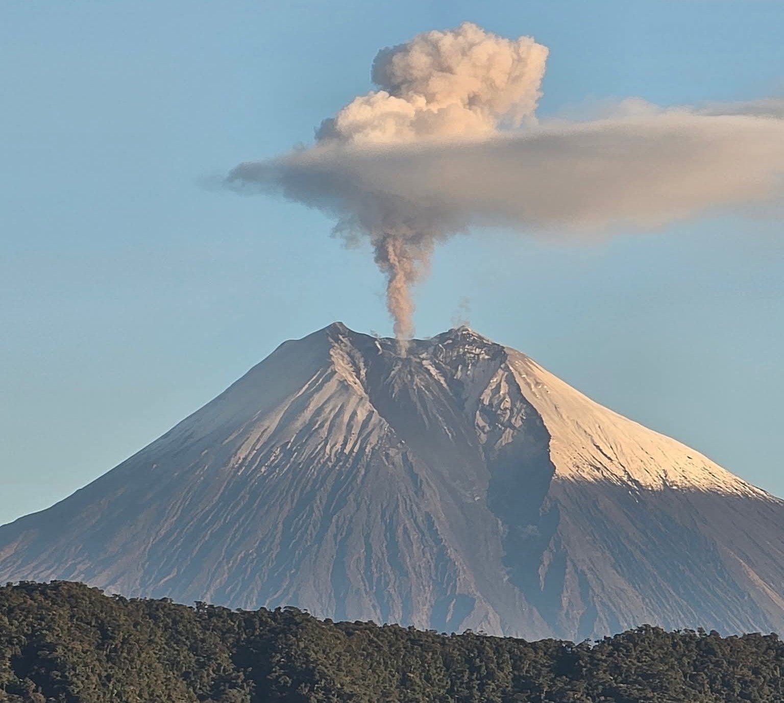
The eruption that began on February 13, 2026, shortly after 10:00 a.m. (local time) at Piton de la Fournaise continues.
Only one eruptive site remains active on the south-southeast flank of the volcano, visible from Piton de Bert. The eruptive cone is now well-formed and continues to close progressively. Few ejecta now exceed the height of the cone.
With the lateral closure of the cone, significant lava tube activity is now established. Since March 3, lava flows have been visible again in the Grandes Pentes area.
The lava field emitted from the eruptive site still forms two main arms. The northern lava flow front remains stationary approximately 2.6 km from National Route 2 (RN2), at an altitude of about 660 m. The southern lava flow has split into several secondary branches, which continue to advance at highly variable speeds, influenced by the topography and vegetation encountered along its path, which can locally slow or channel the flow.
After crossing National Route 2 (RN2) on March 13, the various secondary lava flows continued their advance toward the ocean on March 14.
Since late morning on March 14, the lava flow fronts downstream of RN2 have remained virtually unchanged, and the lowest point in altitude was located this morning at 2:00 AM local time, approximately 150 m from the ocean.

Upstream of the road, several resurgences and new secondary lava flows have been observed on the south side. These flows are being monitored to assess their progression and potential impacts on the RN2 highway.
The significant slowing and subsequent cessation of the lava fronts downstream of the road can be explained by the establishment of these new flows upstream.
As in previous days, seismic activity remains low.
The inflation of the edifice, visible particularly on the summit GNSS stations and at the base of the terminal cone, continues. Since the end of February, the baselines crossing the summit have recorded an increase in distance, indicating a progressive re-expansion of the edifice.
Following a sharp drop on March 11 in the lava and gas emission indicator at the surface, the intensity of the tremor is slowly increasing again. Surface flow rates, estimated from satellite data via the HOTVOLC platform (OPGC – Clermont Auvergne University), have ranged from 1 to 8 m³/s over the past 24 hours. It should be noted that these estimates can vary significantly depending on cloud cover and become zero in the event of total cloud cover.
Current lava tube activity also tends to underestimate the flow rates observed by satellite methods.
Alert Level 2.2
Source : OVPF / IPGP.
Photo : Franck Grondin/Frog 974 Photographies/FB.
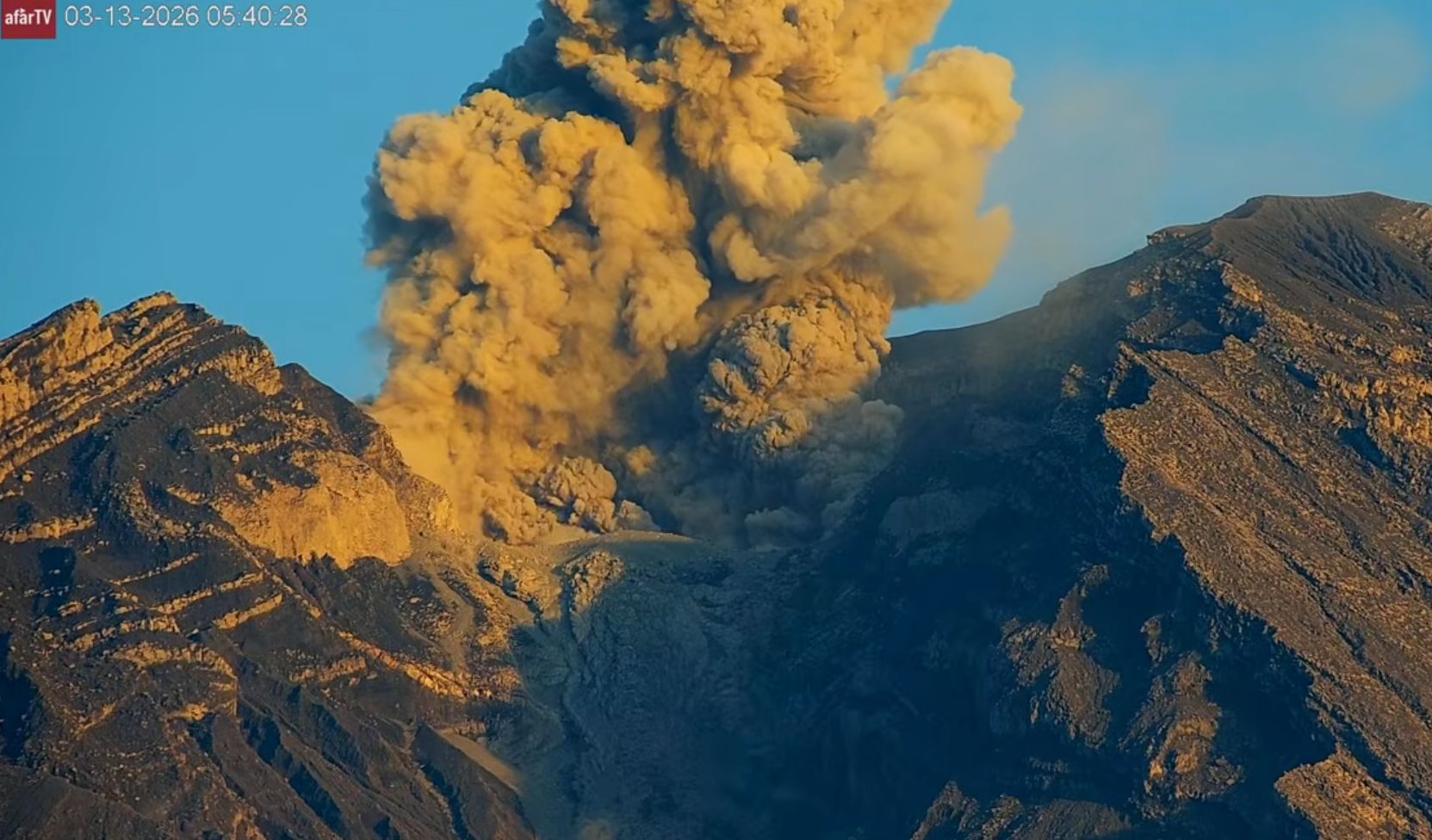
Indonesia , Semeru :
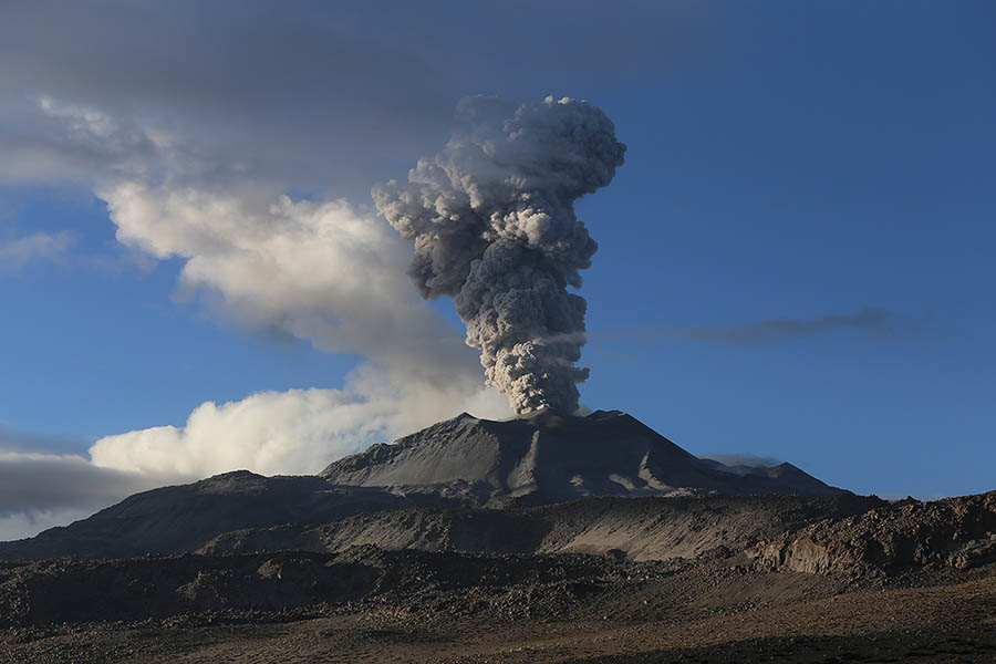
Mount Semeru experienced an eruption on Sunday, March 15, 2026 at 5:47 AM WIB. An ash column was observed approximately 1,200 meters above the summit (at an altitude of about 4,876 meters). This column, white to gray in color and of moderate intensity, was drifting southward. At the time of writing, the eruption was still ongoing.
VOLCANO OBSERVATORY NOTICE FOR AVIATION – VONA
Issued : March 15 , 2026
Volcano : Semeru (263300)
Current Aviation Colour Code : ORANGE
Previous Aviation Colour Code : orange
Source : Semeru Volcano Observatory
Notice Number : 2026SMR525
Volcano Location : S 08 deg 06 min 29 sec E 112 deg 55 min 12 sec
Area : East java, Indonesia
Summit Elevation : 11763 FT (3676 M)
Volcanic Activity Summary :
Eruption with volcanic ash cloud at 22h47 UTC (05h47 local).
Volcanic Cloud Height :
Best estimate of ash-cloud top is around 15603 FT (4876 M) above sea level or 3840 FT (1200 M) above summit. May be higher than what can be observed clearly. Source of height data: ground observer.
Other Volcanic Cloud Information :
Ash cloud moving to south. Volcanic ash is observed to be white to gray. The intensity of volcanic ash is observed to be medium.
Remarks :
Eruption recorded on seismogram with maximum amplitude 22 mm and maximum duration 133 second.
Source : Magma Indonésie.
Photo : Afar TV.
Alaska , Atka :
AVO/USGS Volcanic Activity Notice
Current Volcano Alert Level: ADVISORY
Previous Volcano Alert Level: WATCH
Current Aviation Color Code: YELLOW
Previous Aviation Color Code: ORANGE
Issued: Saturday, March 14, 2026, 5:36 PM AKDT
Source: Alaska Volcano Observatory
Notice Number: 2026/A171
Location: N 52 deg 19 min W 174 deg 8 min
Elevation: 5030 ft (1533 m)
Area: Aleutians
Volcanic Activity Summary:
Correction: The previous report mistakenly raised to color code to Orange and Alert Level to Watch. The correct Aviation color code is Yellow and the Alert level is Advisory.
A substantial increase in seismicity was detected at the Atka volcano complex between 4:20-4:30 PM AKST March 14 (00:20-00:30 March 15 UTC). Small earthquakes and weak tremor have been observed over the past week and elevated levels of sulfur dioxide gas has been detected in satellite data. This activity increases the likelihood of explosive events at the one of the volcanoes within the Atka volcano complex, most likely Korovin. The Alaska Volcano Observatory is increasing the Aviation Color Code to YELLOW and the Volcano Alert Level to ADVISORY.
Remarks:
The Atka volcanic complex forms the northern part of Atka Island, located about 16 km north of the community of Atka and 1,761 km southwest of Anchorage. The Atka volcanic complex includes a possible older caldera and several younger vents, including Korovin Volcano, Mount Kliuchef, and Sarichef Volcano. Korovin Volcano, a 1553-m-high (5030 ft) stratovolcano, has been the site of most historical volcanic activity, and has a small, roiling crater lake that occasionally produces energetic steam emissions. Korovin has erupted several times in the past 200 years, including 1973, 1987, and 1998, and has likely had small ash emissions as recently as 2005. Typical recent Korovin eruptions produce minor amounts of ash and occasional but small lava flows. Reports of the height of the ash plume produced by the 1998 eruption ranged as high as 10,600 m (35,000 feet) above sea level. Mount Kliuchef is composed of a series of five vents aligned northeast–southwest. The two main summit vents of Kliuchef appear relatively young and the easternmost was probably the source of an 1812 eruption that is sometimes attributed to Sarichef.
Source : AVO
Photo : Lopez, Taryn / Alaska Volcano Observatory / University of Alaska Fairbanks, Geophysical Institute.
Ecuador , Sangay :
DAILY REPORT ON THE STATE OF SANGAY VOLCANO, Saturday, March 14, 2026.
Geophysical Information Institute – EPN.
Surface Activity Level: High, Surface Trend: No Change
Internal Activity Level: Moderate, Internal Trend: No Change
Seismicity: From March 13, 2026, 11:00 AM to March 14, 2026, 11:00 AM:
Seismicity:
Explosions (EXP): 285
Precipitation/Lahars:
No precipitation has been recorded in the volcano area. **Heavy rainfall could remobilize accumulated material, generating mud and debris flows that would cascade down the volcano’s flanks and flow into nearby rivers.
Ash plume:
Since yesterday afternoon, several gas and ash emissions have been recorded by the monitoring camera system and the GOES-19 satellite. These emissions are drifting northeast, reaching altitudes between 700 and 900 meters above the crater. In connection with this activity, the Washington VAAC issued three reports indicating ash clouds reaching altitudes between 900 and 1,200 meters above the crater, drifting east-southwest and northeast.
Gas:
The Mounts satellite system detected 100.6 tons of sulfur dioxide (SO₂), measured yesterday at 1:16 p.m. local time.
Other monitoring parameters:
Over the past 24 hours, the FIRMS satellite system recorded 17 thermal anomalies, the MIROVA-VIIRS 750 system recorded 1, the MIROVA-MODIS system recorded 3, and the MIROVA-LANDSAT system recorded 1.
Observation:
Since yesterday evening and early this morning, surveillance cameras have recorded incandescent material descending the volcano’s flanks, reaching as low as 1,400 meters below the crater. At the time of writing, the volcano remains shrouded in clouds.
Alert level: Yellow
Source : IGEPN
Photo : Missael Rivadeneira / Volcan Sangay / FB.
Peru , Sabancaya :
Local date and time: March 9, 2026 – 12:18 PM
Bulletin analysis period: March 2-8, 2026
Volcanic alert level
Orange alert level: The volcano’s eruptive activity has increased significantly. Increased seismic activity, frequent explosions, and emissions of ash and ballistic fragments have been observed.
Conclusions
During this period, fourteen volcanic explosions were detected, generating columns of ash and gas up to 2,800 meters above the volcano’s summit, in addition to seismic activity associated with the movement of magmatic fluids and internal fracturing. Therefore, the volcanic alert level remains orange.
Recommendations
Adopt the current preventative measures due to the orange volcanic alert level.
Do not approach within 12 km of the crater. In case of ashfall, cover your nose and mouth with damp cloths or a mask. Keep doors and windows closed.
Outlook
The occurrence of future volcanic explosions generating eruptive columns more than 2 km high is considered likely. These explosions could affect districts in the Colca Valley and surrounding areas through the dispersal of volcanic ash. Therefore, the volcanic alert level remains orange.
Between March 9 and 12, if ash emissions occur, they will disperse towards the northwest and west sectors of the volcano. From March 13 to 15, the dispersal will be towards the north and northeast sectors of Sabancaya, with winds of 50 km/h.
Source et photo : Cenvul.