June 24 , 2026.
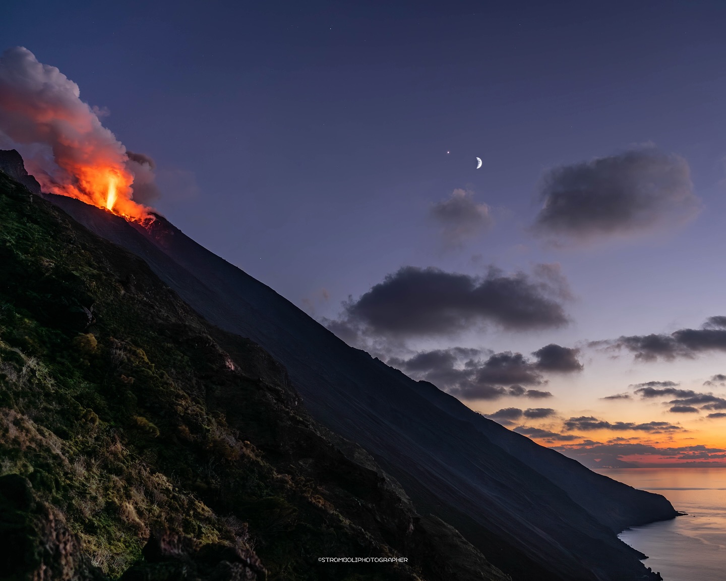
Italy , Stromboli :
WEEKLY BULLETIN, June 15, 2026 – June 21, 2026. (Date of issue: June 23, 2026)
ACTIVITY SUMMARY
Based on monitoring data, the observations are as follows:
1) VOLCANOLOGICAL OBSERVATIONS: Ordinary Strombolian eruptive activity across both crater zones, accompanied by lava spattering of varying intensity in the North Crater zone. The frequency of total explosive activity—encompassing both the North Crater zone and the Central-South Crater zone—was at a medium level, with medium explosion intensity in both zones.
2) SEISMOLOGY: Monitored seismic parameters show no significant variation.
3) GROUND DEFORMATION: The GNSS network recorded no significant variation during the week.
4) GEOCHEMISTRY: SO2 flux at a low level.
Soil CO2 flux in the Pizzo area (STR02): no updated data available.
C/S ratio in the plume: remained at medium values over the past week.
Helium isotope ratio (R/Ra): remains close to the threshold for very high values (R/Ra = 4.48).
Soil CO2 flux in the San Bartolo area: remains at very high levels.
5) SATELLITE OBSERVATIONS: Satellite-observed thermal activity in the summit area remained generally low, with a few isolated anomalies of moderate intensity.
VOLCANOLOGICAL OBSERVATIONS
During the observation period, the overall average hourly explosion frequency remained at a moderate level, with a slight increase in the South-Central crater zone (SC zone) starting on June 19. Explosions in the North crater zone (N zone) were fed by five vents: two active in the N1 sector and three in the N2 sector. These five vents primarily produced coarse material (bombs and lapilli). The average explosion frequency for the North zone remained within a moderate range, and the intensity stayed predominantly moderate. In the South-Central zone, two explosive vents were observed producing fine material mixed with coarse material; the average explosion frequency ranged from low to moderate starting on June 19. The intensity of explosive activity remained moderate overall.
Source : INGV.
Photo : Stromboli stati d’animo / Sebastiano Cannavo
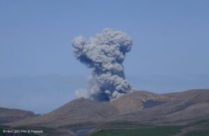
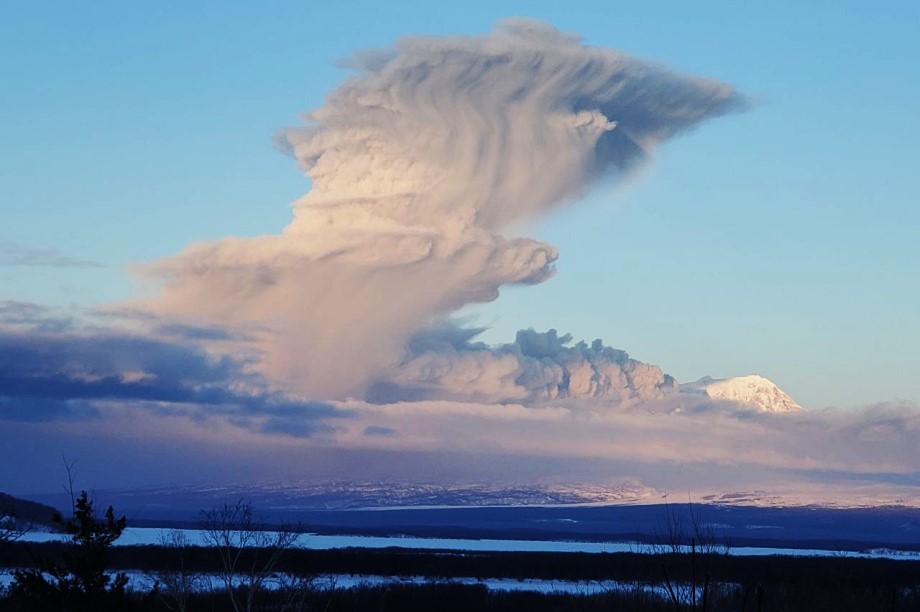
Kamchatka , Sheveluch :
KVERT VOLCANIC ACTIVITY NOTICE (VAN)
Issued: June 23 , 2026
Volcano: Sheveluch (CAVW #300270)
Current aviation colour code: ORANGE
Previous aviation colour code: orange
Source: KVERT
Notice Number: 2026-57
Volcano Location: N 56 deg 38 min E 161 deg 19 min
Area: Kamchatka, Russia
Summit Elevation: 3283 m (10768.24 ft), the dome elevation ~2500 m (8200 ft)
Volcanic Activity Summary:
The explosive-extrusive eruption of the volcano continues, accompanied by powerful gas-steam activity; a new block of lava continues to grow in the northern part of the lava dome. According to satellite data, an explosive event with ash removal up to 4 km a.s.l. began at 19:40 UTC on 23 June. At now an ash cloud move for 50 km to the southwest of the volcano.
This explosive-extrusive eruption of the volcano continues. Ash explosions up to 12 km (39,400 ft) a.s.l. could occur at any time. Ongoing activity could affect international and low-flying aircraft.
Volcanic cloud height:
4000 m (13120 ft) AMSL Time and method of ash plume/cloud height determination: 20260623/1940Z – Himawari-9 14m15
Other volcanic cloud information:
Distance of ash plume/cloud of the volcano: 50 km (31 mi)
Direction of drift of ash plume/cloud of the volcano: WSW / azimuth 252 deg
Time and method of ash plume/cloud determination: 20260623/2050Z – Himawari-9 14m15
Source : Kvert .
Photo : Yu. Demyanchuk.
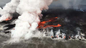
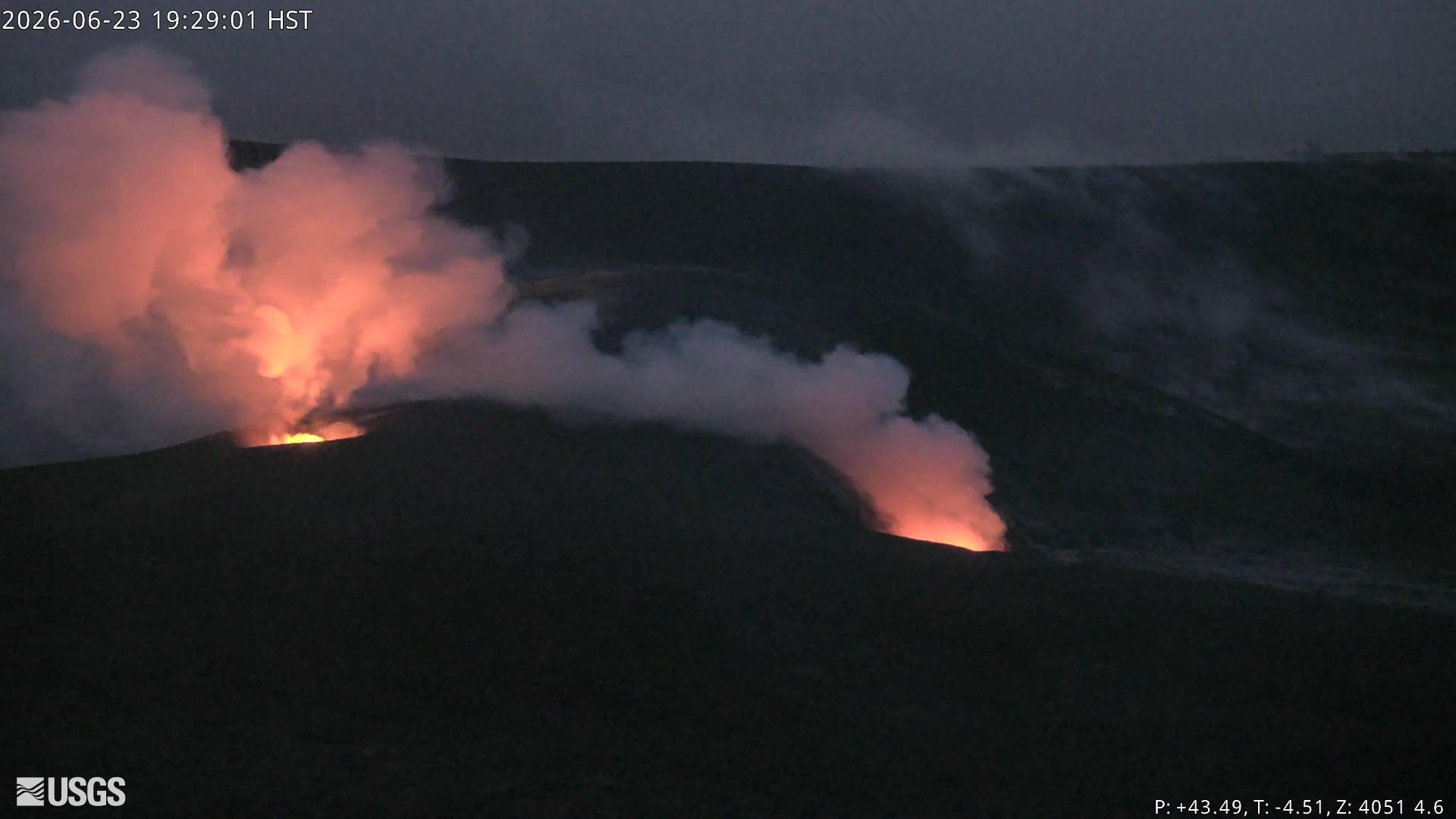
Hawaii , Kilauea :
HAWAIIAN VOLCANO OBSERVATORY DAILY UPDATE , U.S. Geological Survey
Tuesday, June 23, 2026, 8:13 AM HST (Tuesday, June 23, 2026, 18:13 UTC)
19°25’16 » N 155°17’13 » W,
Summit Elevation 4091 ft (1247 m)
Current Volcano Alert Level: ADVISORY
Current Aviation Color Code: YELLOW
Summary:
Kīlauea volcano is not erupting; the summit eruption in Halemaʻumaʻu is paused. The onset of episode 50 fountains is likely between June 25 and June 27 with June 26 most likely.
Overview:
The summit eruption of Kīlauea in Halemaʻumaʻu remains paused. Summit inflation, strong vent glow and flaming, and degassing continues, indicating that another episode is likely. Forecast models indicate that the onset of fountaining episode 50 is likely to begin between June 25 and June 27 with June 26 most likely.
No significant activity has been noted along Kīlauea’s East Rift Zone or Southwest Rift Zone.
Summit Observations:
Continuous strong glow was visible on webcams from both vents in Halemaʻumaʻu overnight. The south vent continued to produced large flames caused by the burning of gas within the top of the conduit. Magma is close to the surface.
Pulses of seismic tremor continued (every 10-20 minutes) in the last 24 hours. One magnitude 1.0 earthquake was identified at Kīlauea volcano’s summit in the past 24 hours.
Kīlauea summit deflation totaled 15.5 microradians during episode 49. Once the episode ended, inflation resumed and has since recovered 12.6 microradians of tilt at the summit tiltmeter at Uēkahuna (UWD).
With the eruption now paused, the sulfur dioxide (SO2) emission rate from the summit is likely now varying within a typical range of 1,000 to 5,000 tonnes per day.
Rift Zone Observations:
Rates of seismicity and ground deformation remain low in the East Rift Zone and Southwest Rift Zone. SO2 emissions from the East Rift Zone remain below the detection limit.
Source et photo : HVO.
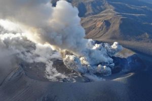
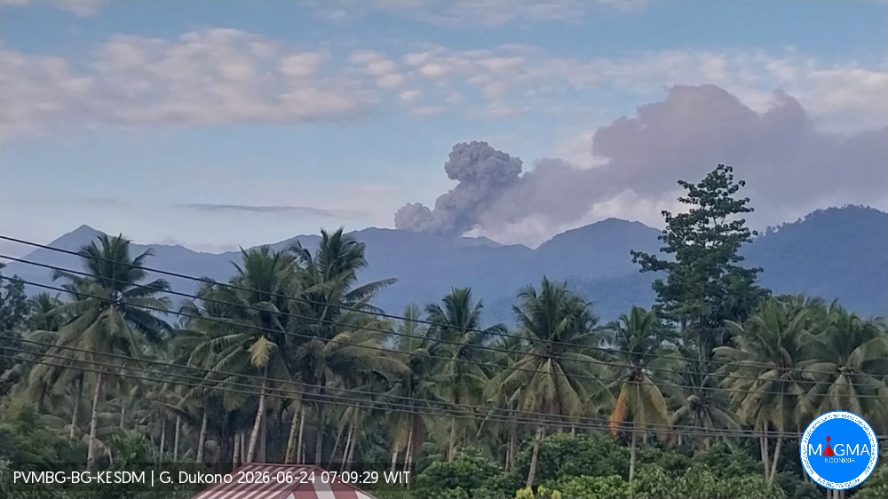
Indonesia , Dukono :
An eruption of Mount Dukono occurred on Wednesday, June 24, 2026, at 07:04 (WIT); the observed ash plume reached a height of approximately 500 m above the summit (1,587 m above sea level). The plume, which was dense and white to gray in color, drifted northwest. The eruption was recorded by the seismograph with a maximum amplitude of 34 mm and a duration of 40.99 seconds.
Seismic observations
12 eruption earthquakes with amplitudes of 6–12 mm and durations of 20.56–62.11 seconds.
19 low-frequency earthquakes with amplitudes of 3–5 mm and durations of 14.43–33.97 seconds.
2 distant tectonic earthquakes with an amplitude of 34 mm and durations of 91.17–115.08 seconds.
1 episode of continuous tremor with an amplitude of 1–5 mm (dominant amplitude: 2 mm).
Recommendations
(1) Communities living near Mount Dukono, as well as visitors and tourists, are advised not to engage in activities, hike, or approach the Malupang Warirang crater within a 4 km radius.
(2) Given that ash-producing eruptions occur periodically and ash dispersion depends on wind direction and speed—resulting in variable affected areas—communities near Mount Dukono are advised to keep masks or nose and mouth protection close at hand to guard against respiratory health risks associated with volcanic ash.
Source et photo : PVBG.
Colombia , Puracé – Los Coconucos volcanic chain :
Popayán, June 23, 2026, 12:00 PM.
Based on monitoring of the Puracé–Los Coconucos volcanic chain, the Colombian Geological Service (SGC)—an agency attached to the Ministry of Mines and Energy—
reports the following:
During the week of June 16–22, 2026, seismic activity associated with fluid movement (gases and liquids originating from magma and its interaction with the hydrothermal system) beneath the Puracé volcano crater continued to increase; this activity is occurring at depths of less than 3 km, as noted the previous week. The number of daily ash emissions decreased, and the associated plumes dispersed toward the northwest, reaching a maximum height of 2 km above the volcano’s summit.
At the same time, seismicity associated with rock fracturing (VT) showed a decline—in both the number of events and the seismic energy released—compared to previous weeks.
These earthquakes were primarily located between the Puracé and Piocollo volcanoes, at depths ranging from 1 to 3 km, with magnitudes below 1.
Images captured by webcams (visible and infrared spectrum) continued to show thermal anomalies inside the Puracé volcano crater and in the fumarole zone on its outer rim, as well as degassing processes in the craters of the Puracé and Curiquinga volcanoes. Sulfur dioxide (SO2) emissions into the atmosphere are
also continuing. The slow deformation process previously recorded in the area between the Puracé, Piocollo, and Curiquinga volcanoes is still ongoing.

In conclusion, the variations observed at the Puracé volcano—part of the Los Coconucos volcanic chain—indicate that the system continues to evolve; further ash emissions and fallout are possible, with dispersal determined by the prevailing wind direction. Furthermore, additional changes in volcanic activity that could lead to more energetic surface manifestations cannot be ruled out. The public is advised to avoid the upper reaches of the volcanic chain and to stay informed via official SGC reports.
The volcanic alert level remains at « Yellow »: an active volcano showing changes in the baseline behavior of monitored parameters, as well as other manifestations.
Source et photo : SGC.