June 25 , 2026.
Indonesia , Semeru :
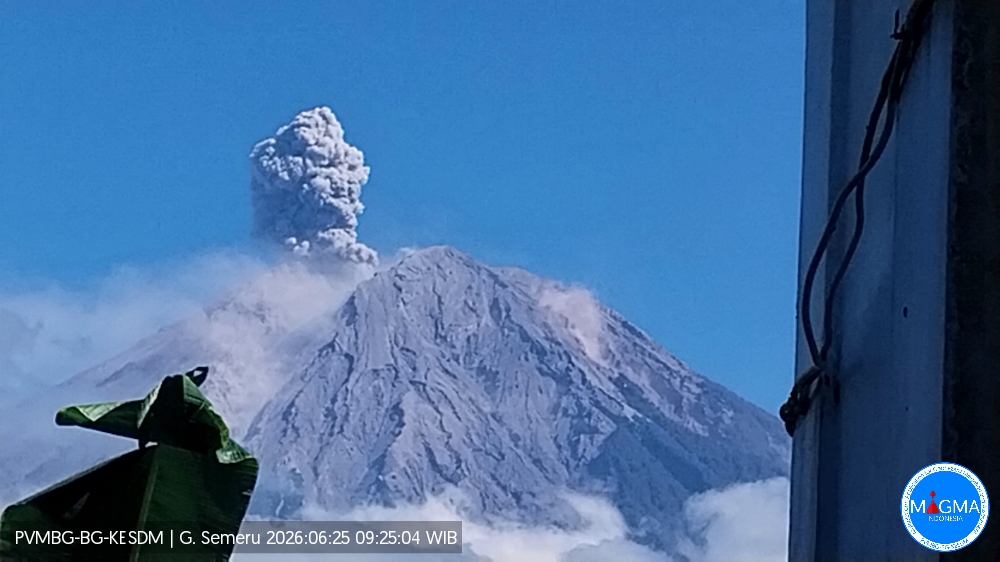
An eruption of Mount Semeru occurred on Thursday, June 25, 2026, at 09:24 (Western Indonesia Time), with an ash column reaching a height of approximately 1,200 m above the summit (or about 4,876 m above sea level). The observed column, ranging from white to gray in color and of moderate intensity, was drifting southward. At the time of writing this report, the eruption was still ongoing.
VOLCANO OBSERVATORY NOTICE FOR AVIATION – VONA
Issued : June 25 , 2026
Volcano : Semeru (263300)
Current Aviation Colour Code : ORANGE
Previous Aviation Colour Code : orange
Source : Semeru Volcano Observatory
Notice Number : 2026SMR1267
Volcano Location : S 08 deg 06 min 29 sec E 112 deg 55 min 12 sec
Area : East java, Indonesia
Summit Elevation : 11763 FT (3676 M)
Volcanic Activity Summary :
Eruption with volcanic ash cloud at 02h24 UTC (09h24 local).
Volcanic Cloud Height :
Best estimate of ash-cloud top is around 15603 FT (4876 M) above sea level or 3840 FT (1200 M) above summit. May be higher than what can be observed clearly. Source of height data: ground observer.
Other Volcanic Cloud Information :
Ash cloud moving to south. Volcanic ash is observed to be white to gray. The intensity of volcanic ash is observed to be medium.
Remarks :
Eruption recorded on seismogram with maximum amplitude 22 mm and maximum duration 146 second.
Source et photo : PVMBG.
Colombia , Chiles / Cerro Negro :
San Juan de Pasto, June 23, 2026, 2:50 PM
Based on monitoring of the activity at the Chiles-Cerro Negro volcanic complex (CVCCN), the Colombian Geological Service (SGC)—an agency under the Ministry of Mines and Energy—reports the following information:
For the period from June 16 to June 22, 2026, the main changes in monitored parameters compared to the previous week were as follows:
● Regarding seismic activity, a slight decrease in event frequency was recorded, along with a drop in released energy. Seismicity associated with rock-fracturing processes predominated, followed by activity linked to fluid dynamics.
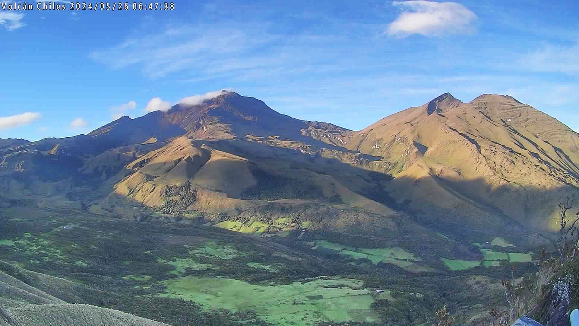
● Localized earthquakes were concentrated near the southern sector of the Chiles volcano; generally, the depth of these earthquakes ranged from 2 to 8 km below the volcano’s summit (4,700 meters above sea level). The maximum recorded magnitude was 1.7.
● Analysis of data from satellite sensors and ground stations continued to show variations associated with deformation processes in the volcanic zone.
Based on the assessment and correlation of monitored parameters, the SGC recommends closely following the situation’s evolution via weekly bulletins and other information published through our official channels, as well as adhering to instructions from local and departmental authorities and the National Unit for Disaster Risk Management (UNGRD).
Volcanic activity remains at the yellow alert level: an active volcano showing changes in the baseline behavior of monitored parameters and other manifestations.
Source et photo : SGC.
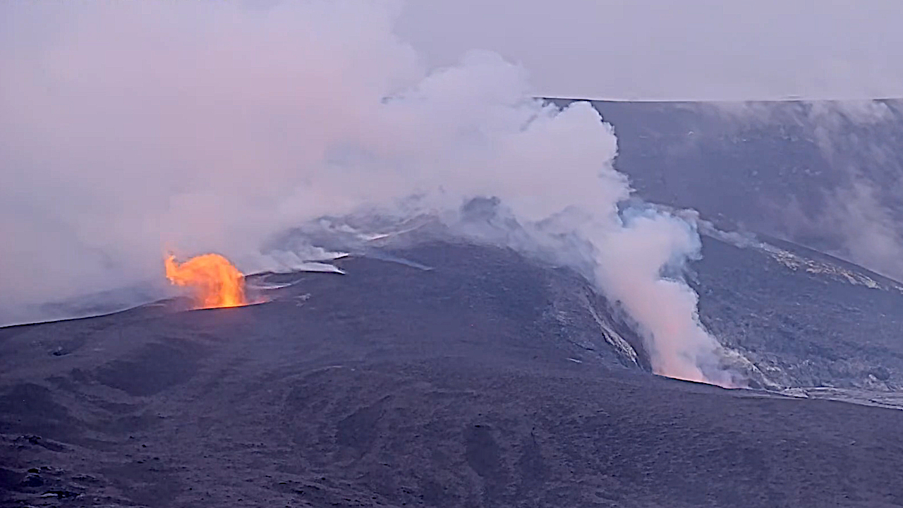
Hawaii , Kilauea :
HAWAIIAN VOLCANO OBSERVATORY DAILY UPDATE , U.S. Geological Survey
Wednesday, June 24, 2026, 9:26 AM HST (Wednesday, June 24, 2026, 19:26 UTC)
19°25’16 » N 155°17’13 » W,
Summit Elevation 4091 ft (1247 m)
Current Volcano Alert Level: ADVISORY
Current Aviation Color Code: YELLOW
Summary:
Kīlauea volcano is not erupting; the summit eruption in Halemaʻumaʻu is paused. The onset of episode 50 fountains is likely between June 25 and June 27 with June 26 most likely.
Overview:
The summit eruption of Kīlauea in Halemaʻumaʻu remains paused. Summit inflation, strong vent glow and flaming, and degassing continues, indicating that another episode is likely. Forecast models indicate that the onset of fountaining episode 50 is likely to begin between tomorrow June 25 and Saturday June 27 with Friday June 26 most likely.
No significant activity has been noted along Kīlauea’s East Rift Zone or Southwest Rift Zone.
Summit Observations:
Continuous strong glow was visible on webcams from both vents in Halemaʻumaʻu overnight. The south vent continued to produced large flames caused by the burning of gas within the top of the conduit. Magma is close to the surface.
Pulses of seismic tremor continued (every 10-20 minutes) in the last 24 hours. No earthquakes were located beneath Kīlauea volcano’s summit in the past 24 hours.
Kīlauea summit deflation totaled 15.5 microradians during episode 49. Once the episode ended, inflation resumed and has since recovered 13.6 microradians of tilt at the summit tiltmeter at Uēkahuna (UWD).
With the eruption now paused, the sulfur dioxide (SO2) emission rate from the summit is likely now varying within a typical range of 1,000 to 5,000 tonnes per day.
Rift Zone Observations:
Rates of seismicity and ground deformation remain low in the East Rift Zone and Southwest Rift Zone. SO2 emissions from the East Rift Zone remain below the detection limit.
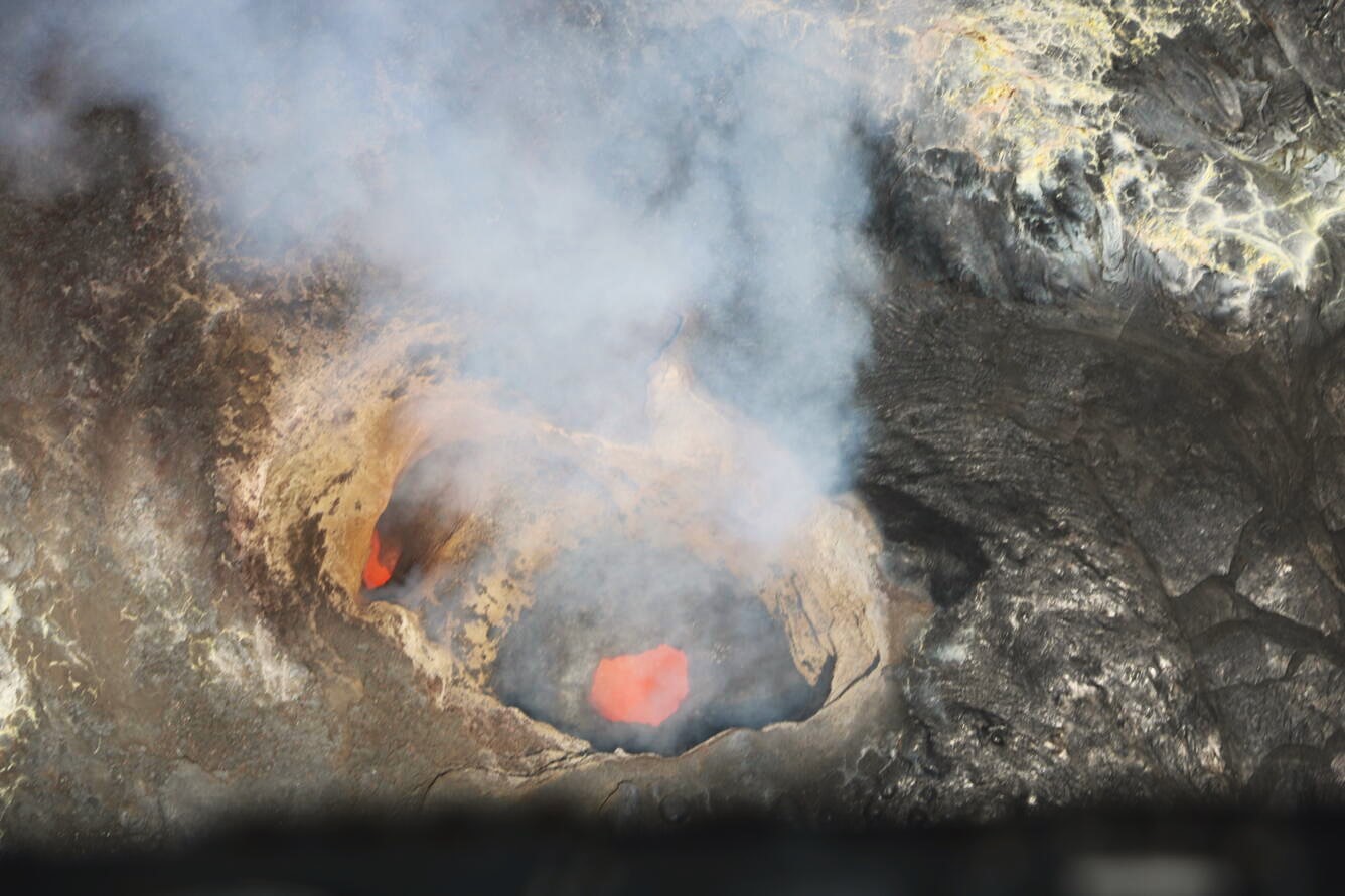
During a USGS Hawaiian Volcano Observatory monitoring overflight of Kīlauea summit on June 24, 2026, scientists captured this view looking down into the bifurcated structure within the north vent in Halemaʻumaʻu crater. Magma was visible roiling within the vent
Magnitude-3.6 earthquake south of the village of Volcano, Island of Hawaiʻi, June 24, 2026, 8:29 a.m. HST
A magnitude-3.6 earthquake occurred this morning at 8:29 a.m. It was located 9 mi (14 km) south of the village of Volcano on the Island of Hawaiʻi at a depth of 5 mi (7 km) below sea level. The earthquake had no apparent impact on either Mauna Loa or Kīlauea volcanoes. Most earthquakes in this region are caused by motion of Kīlauea volcano’s south flank, which moves to the southeast over the oceanic crust. The location, depth, and waveforms recorded as part of today’s earthquake are consistent with slip along Kīlauea’s south flank. No damage to buildings or infrastructure is expected based on earthquake intensity. This earthquake is not directly related to the ongoing eruptive activity on Kīlauea volcano.
Analysis:
The abrupt switch from deflation to inflation at the end of episode 49 along with continued tremor and glow from the vents indicates that episode 50 fountaining is likely. Magma remains close to the surface although no spattering or overflows have been observed at this time. Forecast models suggest another fountaining episode may occur between June 25-27 with June 26 most likely.
Kīlauea has been erupting episodically since December 23, 2024, from two vents (north and south) in Halema‘uma‘u. Lava fountaining episodes, which generally last for less than 12 hours, are separated by pauses that can be longer than three weeks.
Source : HVO.
Photos : USGS , USGS / K. Mulliken.
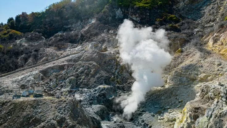
Italy , Campi Flegrei :
Weekly bulletin, June 15, 2026 – June 21, 2026. (Date of issue: June 23, 2026)
ACTIVITY STATUS SUMMARY
Monitoring data indicate the following:
1) SEISMOLOGY: During the week of June 15–21, 2026, 36 earthquakes with magnitude Md ≥ 0.0 (Mdmax = 1.4 ± 0.3) were located in the Campi Flegrei area, out of a total of 75 events (-0.8 ≤ Md ≤ 1.4).
2) DEFORMATION: Since the beginning of February 2026, the average monthly uplift rate in the area of maximum deformation has been approximately 10 ± 3 mm/month.
3) GEOCHEMISTRY: During the week in question, monitored geochemical parameters confirm the long-term trend of hydrothermal system heating and increasing fluxes (see monthly bulletins). The temperature of the BG fumarole, located in the Solfatara crater, has shown an upward trend in recent months; the average value for the period is approximately 173°C.
GEOCHEMISTRY
During the week in question, continuous monitoring data from the geochemical network remained consistent with trends of heating and pressurization within the hydrothermal system, as well as with the increase in fluid discharge.
In the Pisciarelli area (on the outer northeastern flank of the Solfatara)—which has experienced the most marked changes in degassing processes in recent years—soil CO2 flux values continuously recorded by the FLXOV8 station showed no significant variation over the past week compared to previous periods, remaining consistent with the multi-year upward trend observed in this area.
On June 25, 2026, at 04:17 (local time), a seismic event with a magnitude of Md = 3.6 ± 0.3 was recorded in the Campi Flegrei area.
Source et photo : INGV
Mexico , Popocatepetl :
Activity over the past 24 hours
161 exhalations, 53 minutes of tremor, and 202 minutes of exhalation sequences were detected.
Popocatépetl’s volcanic alert level is currently set to Yellow Phase 2.
Cenapred strongly advises against attempting to climb the volcano, as explosions eject incandescent fragments, as recently observed. Please respect the 12-kilometer safety perimeter around the crater; entering this zone is dangerous. In the event of heavy rain, stay away from ravine bottoms due to the risk of mud and debris flows.
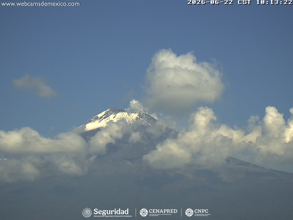
The official warning level remains unchanged at Yellow Phase 2, the second-highest level of the yellow alert phase. According to authorities, minor to moderate explosions are still possible. Rock fragments may fall back into the area surrounding the crater.
Source et photo : Cenapred .