June 23 , 2026.
Alaska , Kupreanof :
ALASKA VOLCANO OBSERVATORY INFORMATION STATEMENT , U.S. Geological Survey
Monday, June 22, 2026, 3:52 PM AKDT (Monday, June 22, 2026, 23:52 UTC)
56°45″ N 159°47’28 » W,
Summit Elevation 6217 ft (1895 m)
Current Volcano Alert Level: ADVISORY
Current Aviation Color Code: YELLOW
Summary:
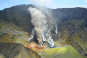
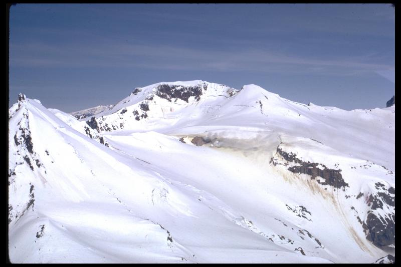
Seismic activity and gas emissions continue at Mount Kupreanof alongside newly detected ground deformation, consistent with the ongoing intrusion of magma beneath the volcano.
Overview
Seismic activity and sulfur dioxide (SO2) emissions from Mount Kupreanof have remained elevated since the Aviation Color Code and Volcano Alert Level change to YELLOW/ADVISORY on May 12.
New satellite deformation measurements have detected uplift of the ground surface in the area around the volcano occurring sometime since October 2025.
The seismicity, gas, and deformation signals are due to a magmatic intrusion beneath the volcano.
The volcano remains at YELLOW/ADVISORY, and there are no indications from available data that an eruption is imminent.
Earthquakes
Seismic unrest that began in February 2026 beneath Mount Kupreanof continues. Since the Aviation Color Code and Volcano Alert Level change to YELLOW/ADVISORY on May 12, shallow seismicity has remained elevated with more than 30 earthquakes of magnitude 1 or greater. The largest events to date occurred on June 15 and 16 and had magnitudes of 3.2 and 3.6, respectively.
The Alaska Volcano Observatory (AVO) does not maintain a local monitoring network at Mount Kupreanof, and seismicity is therefore detected using regional stations. The closest functioning seismometer is currently located 17 miles (27 km) to the east at Mount Veniaminof. The lack of a local monitoring network and the limited number of regional stations mean that smaller events (magnitudes less than 2) are often not detected or located, and earthquake locations have relatively large uncertainties. The largest earthquakes at Mount Kupreanof may also be analyzed and reported by the Alaska Earthquake Center and the U.S. Geological Survey National Earthquake Information Center. Earthquake magnitudes and locations from these agencies may differ slightly from AVO due to differences in techniques. Mount Kupreanof is also monitored by satellite data, remote infrasound and lightning networks, and visual observations from pilots and mariners passing by the volcano.
Gas Emissions
Since May 12, sulfur dioxide emissions have been seen in satellite data on 13 days with calculated emission rates between 100 to 800 tons per day, similar to the rate of emissions seen since April. These elevated emission rates are consistent with degassing of new, relatively shallow magma beneath the volcano.
Deformation
Satellite interferometric radar (InSAR) ground deformation data collected in mid-June, following sufficient snow melt, compared with data from before snow cover (September 30, 2025) indicate uplift of the ground around the volcano occurred sometime in the past 8 months . The source depth of this inflation signal is likely around 3.7 miles (6 km) below sea level. These results are consistent with a magmatic intrusion, in agreement with the seismic and gas data.
Interpretations and Hazards
The earthquake types and locations, observed sulfur dioxide emissions, and new deformation signal indicate that magma has intruded to relatively shallow depths beneath Mount Kupreanof. No major changes associated with this intrusion have been observed at the steam vents in a fumarole field at about 5,000 ft elevation west of the summit. Because of the active steam venting, if eruptive activity does occur, it may be either hydrothermal (steam driven) or magmatic. Intrusions of new magma under volcanoes do not always result in volcanic eruptions. The earthquake activity, deformation, and gas emissions at Mount Kupreanof may cease with no eruption occurring. If the magma rises closer to the surface, it will likely lead to increased unrest, such as a change in the rate and style of earthquake activity, surface heating, and increased gas emissions. Therefore, it is very likely that if an eruption were to occur it would be preceded by additional signals that would allow advance warning.
If an eruption were to occur, the primary hazards would be from pyroclastic flows, lahars (volcanic debris flows), volcanic ashfall, and airborne volcanic ash. Due to its remote location, pyroclastic flows would only affect uninhabited areas but would likely generate lahars that could inundate rivers to the north and south of the volcano. The areas that could be impacted by ashfall and airborne ash are dependent on the amount of ash produced, the altitude of the ash, and the direction and speed of the wind at the time of the eruption. This could result in ashfall in nearshore waters and potentially on populations in the region. Airborne ash clouds carried by the wind could disrupt regional and international air traffic.
Source : AVO.
Photos : Boyce, Ellie / Alaska Volcano Observatory / University of Alaska Fairbanks, Geophysical Institute , Miller, T. P. Alaska Volcano Observatory / Geophysical Institute .
New Zealand , White Island :
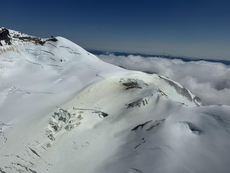
Steam and gas emissions continue at Whakaari/White Island. Volcanic Alert Level remains at 2.
Published: Tue Jun 23 2026 10:30 AM
Based on recent observations from webcam images, a gas flight, and satellite imagery, activity at Whakaari/White Island continues with steam and gas emissions. Activity has been consistent over the past 2 months, with no eruptive activity. The Volcanic Alert Level remains at 2 and the Aviation Colour Code at Yellow.
Since our last bulletin on 7 April 2026, there has been no evidence of ash being emitted at Whakaari/White Island and gas emissions remained at low to moderate levels. Observations from a gas flight last week, along with web camera imagery from the mainland, have confirmed only moderate to low steam and gas emissions are occurring from the active vent. Measurements during the flight found decreased levels of both sulphur dioxide (SO₂) and carbon dioxide (CO₂) since the previous flight on 23 April 2026.
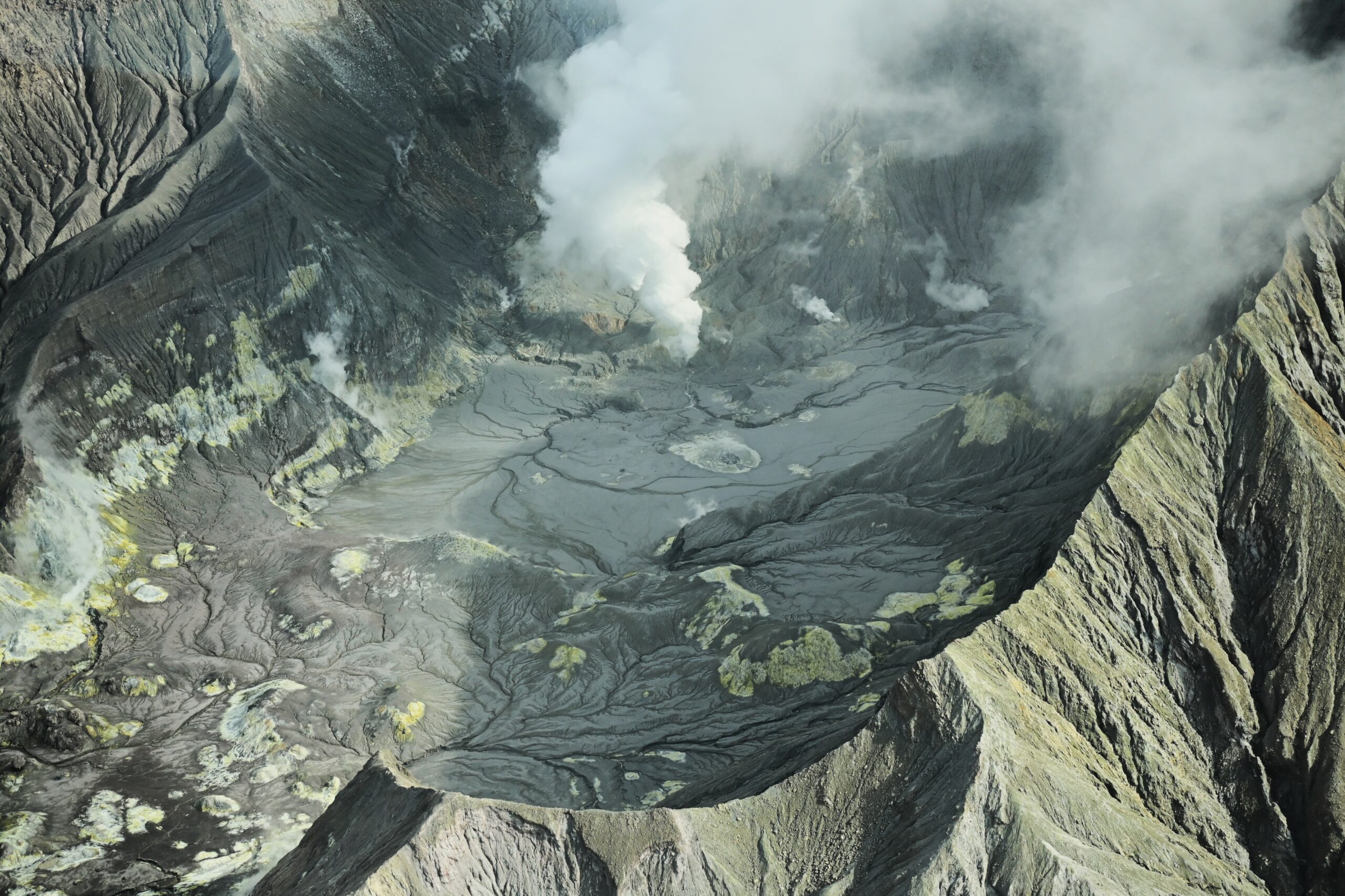
Image of the steam and gas plume at Whakaari/White Island captured on our gas flight on 17 June 2026.
The available data confirm the volcano is not currently erupting, with the overall activity remaining low. The Volcanic Alert Level therefore remains at 2 (moderate to heightened unrest) and Aviation Colour Code at Yellow. Eruptive volcanic activity can still occur with little to no warning. Future eruptions could affect the crater floor and immediate vicinity of the island, while ashfall affecting the mainland remains unlikely.
The Earth Sciences New Zealand Volcano Monitoring Group, and National Geohazards Monitoring Centre continue to closely monitor Whakaari/White Island for any changes in activity. Without sensors on the island, our monitoring of Whakaari/White Island continues to rely on remote cameras, satellite imagery, and periodic gas and observation flights. Given our lack of real-time monitoring data from the island, we cannot distinguish between Volcanic Alert Level (VAL) 1 and 2. As a result, Whakaari/White Island will remain at least at VAL 2 until on-island monitoring is reinstated.
Source et photo : GeoNet / Oliver Lamb / Duty Volcanologist.
Indonesia , Semeru :
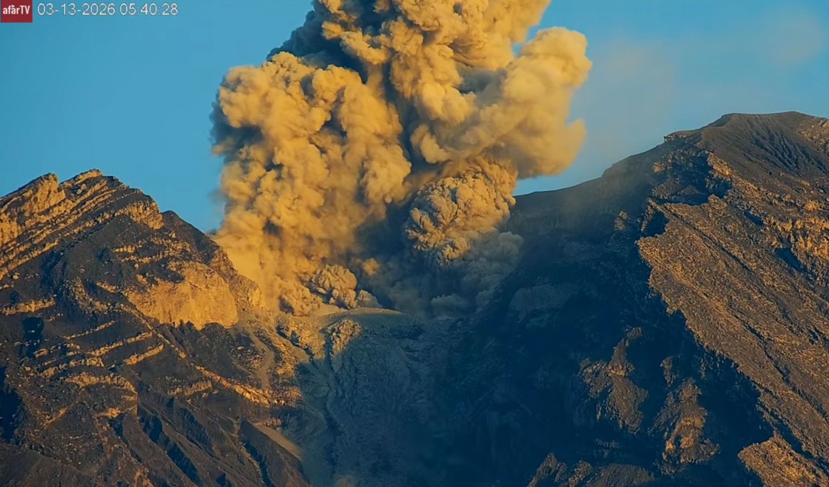
An eruption of Mount Semeru occurred on Tuesday, June 23, 2026, at 05:30 (Western Indonesia Time), with an ash column rising approximately 1,200 m above the summit (or about 4,876 m above sea level). The ash column, of moderate intensity, ranged in color from white to gray and drifted southward. At the time of writing this report, the eruption was still ongoing.
VOLCANO OBSERVATORY NOTICE FOR AVIATION – VONA
Issued : June 23 , 2026
Volcano : Semeru (263300)
Current Aviation Colour Code : ORANGE
Previous Aviation Colour Code : orange
Source : Semeru Volcano Observatory
Notice Number : 2026SMR1243
Volcano Location : S 08 deg 06 min 29 sec E 112 deg 55 min 12 sec
Area : East java, Indonesia
Summit Elevation : 11763 FT (3676 M)
Volcanic Activity Summary :
Eruption with volcanic ash cloud at 22h30 UTC (05h30 local).
Volcanic Cloud Height :
Best estimate of ash-cloud top is around 15603 FT (4876 M) above sea level or 3840 FT (1200 M) above summit. May be higher than what can be observed clearly. Source of height data: ground observer.
Other Volcanic Cloud Information :
Ash cloud moving to south. Volcanic ash is observed to be white to gray. The intensity of volcanic ash is observed to be medium.
Remarks :
Eruption recorded on seismogram with maximum amplitude 22 mm and maximum duration 137 second.
Source : PVMBG.
Photo : afar tv ( archive)
Guatemala , Fuego :
Weather conditions: Clear skies
Wind: From the southeast
Precipitation: 11.9 mm
Activity
During the night and early morning, light-gray degassing was recorded at an altitude of 4,300 meters above sea level. Between 7 and 11 explosions per hour are being recorded—ranging from low to moderate or even high intensity—ejecting gas and ash plumes to altitudes between 4,300 and 4,800 m (14,107–15,748 ft), which are drifting westward and northwestward for distances of up to 30 km.
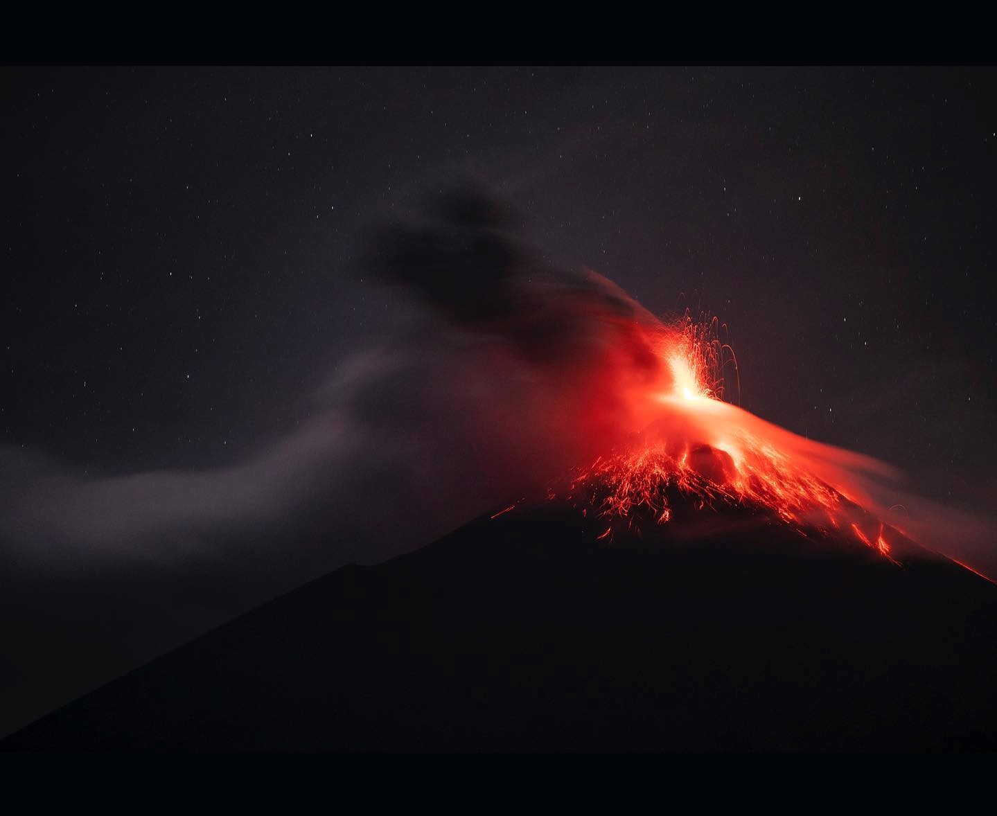
Some explosions are accompanied by noise, rumbling, and weak shockwaves. Incandescent bursts are observed at night, causing incandescent material to fall around the crater and channel into the Seca, Taniluya, Ceniza, Las Lajas, and Honda ravines (among others), sometimes reaching the vegetation line. Fine ashfall is also expected in communities near the volcano’s northwest flank and in surrounding areas. In the event of daytime rainfall, runoff and/or lahars could occur; it is advised to avoid staying inside or near these ravines while it is raining on the volcanic edifice.
Source : Insivumeh .
Photo : Diego Rizzo.
Philippines , Mayon :
Lava effusion accompanied by collapse-induced pyroclastic density currents (PDCs) was observed at Mayon Volcano on Sunday night, as it entered its 167th day of effusive eruption.
The Philippine Institute of Volcanology and Seismology (PHIVOLCS) released time-lapse footage of the volcanic activity on its social media channels.
The lava effusion was recorded between 7:35 p.m. and 7:40 p.m. on Sunday, June 21, 2026.
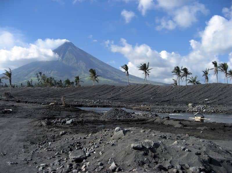
PARAMETERS
Eruption:
Lava effusion with flows in the Basud (3.8 km), Bonga (3.2 km), and Mi-isi (1.8 km) ravines
Seismicity:
12 volcanic earthquakes; 258 rockfalls
Crater glow:
Visible (to the naked eye)
Sulfur dioxide (SO2) flux:
1,313 tonnes/day (June 22, 2026)
Plume:
200 meters above the crater; moderate emission; drifting East-Northeast and East-Southeast
Ground deformation:
Short-term deflation of the edifice, with inflation over a shorter period on the northeast flank
Sources : Phivolcs , GMA network .
Photo : Phivolcs.