December 3 , 2025.
Indonésia , Marapi :
VOLCANO OBSERVATORY NOTICE FOR AVIATION – VONA
Issued : 20251202/0334Z
Volcano : Marapi (261140)
Current Aviation Colour Code : ORANGE
Previous Aviation Colour Code : yellow
Source : Marapi Volcano Observatory
Notice Number : 2025MAR084
Volcano Location : S 0 deg 22 min 52 sec E 100 deg 28 min 23 sec
Area : West Sumatra, Indonesia
Summit Elevation : 9251 FT (2891 M)
Volcanic Activity Summary :
Eruption at 03h34 UTC (10h34 local).
Volcanic Cloud Height :
Ash-cloud is not observed.
Other Volcanic Cloud Information :
Ash-cloud is not observed.
Remarks :
Eruption recorded on seismogram with maximum amplitude 30.3 mm and maximum duration 511 second. Tremor recorded on seismogram with maximum amplitude 5.8 mm.

Seismic Observations
One eruption earthquake with an amplitude of 30.3 mm and a duration of 51 seconds.
One non-harmonic tremor with an amplitude of 5.8 mm and a duration of 162 seconds.
Two shallow volcanic earthquakes with amplitudes between 1.1 and 4 mm and a duration of 18 to 19 seconds.
A local tectonic earthquake with an amplitude of 1.2 mm and a duration of 21 seconds.
Five distant tectonic earthquakes with amplitudes between 1 and 30.5 mm and a duration of 51 to 159 seconds.
One continuous tremor with an amplitude between 0.5 and 1 mm, primarily 1 mm.
Recommendations
1. Communities living near Mount Marapi, as well as climbers, visitors, and tourists, are advised to refrain from all activities within a 3 km radius of the activity center (Verbeek Crater) of Mount Marapi.
2. Communities living near valleys, riverbanks, or streams originating at the summit of Mount Marapi are advised to remain vigilant regarding the risk of lahars (flash floods), particularly during the rainy season.
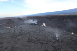
Source : PVMBG.
Photo : Pakdhe Giso / FB.
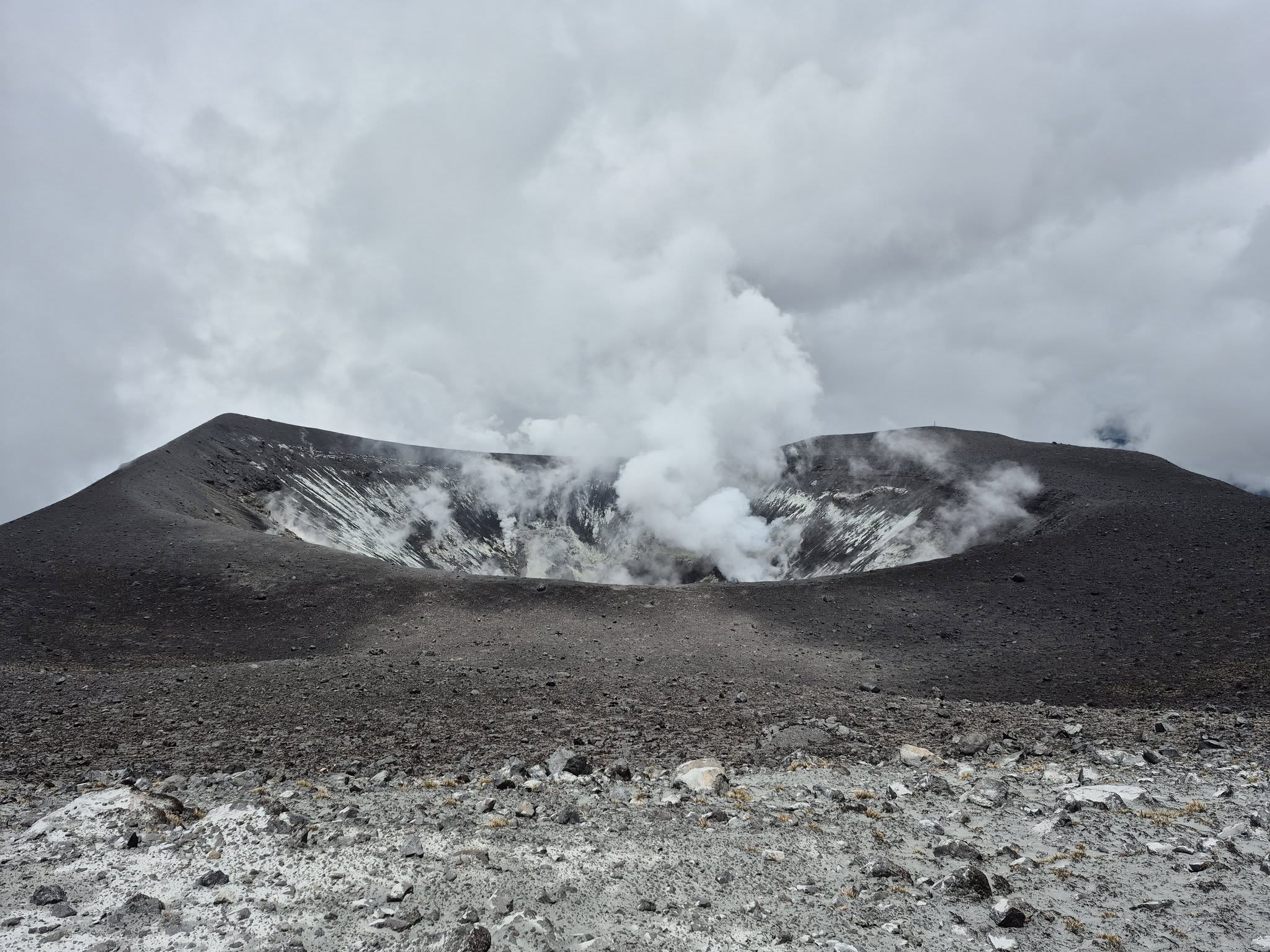
Italy / Sicily , Etna :
MONTHLY BULLETIN, NOVEMBER 2025. (Publication date: 02/12/2025)
ACTIVITY SUMMARY
Based on monitoring data, the following points should be noted:
1) VOLCANOLOGICAL OBSERVATIONS: Variable degassing activity at the summit craters, with episodic ash emissions from the Bocca Nuova crater.
2) SEISMOLOGY: Moderate seismic activity due to fracturing. Average amplitude of volcanic tremor at a moderate level, without significant variations.
3) INFRASOUND: Moderate infrasound activity with sources located in the Northeast Crater (NEC) area and the Bocca Nuova Crater (BN) area.
4) GROUND DEFORMATION: Ground deformation monitoring networks have not measured any significant changes.
5) GEOCHEMISTRY: SO₂ fluxes at a medium-high level.
CO₂ fluxes from the ground (EtnaGas Network): at low values.
Partial pressure of dissolved CO₂ in groundwater (EtnaWater Network): no update.
Helium isotope ratio at peripheral sites: at high values (latest data from November 4).
6) SATELLITE OBSERVATIONS: Over the past month, thermal activity observed by satellite in the summit area has been generally low, with a few isolated anomalies of moderate intensity.
VOLCANOLOGICAL OBSERVATIONS
On days with visibility, it was possible to observe that the summit craters were affected by degassing of varying intensity and pattern.
In particular, thanks to images from surveillance cameras and on-site inspections carried out by INGV-OE staff on November 7 and 14, fumarolic degassing was observed along the rim of the Voragine crater (VOR), continuous degassing from fumaroles along the rim of the Southeast crater (CSE), and pulsatile degassing with episodic and weak ash emissions that rapidly dispersed into the atmosphere from the Bocca Nuova crater (BN). Finally, the Northeast crater (CNE) produced degassing of varying intensity. Glimmers were occasionally observed at night from a vent located on the bottom of the crater, as was observed during the survey on November 14.
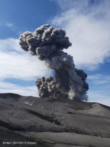
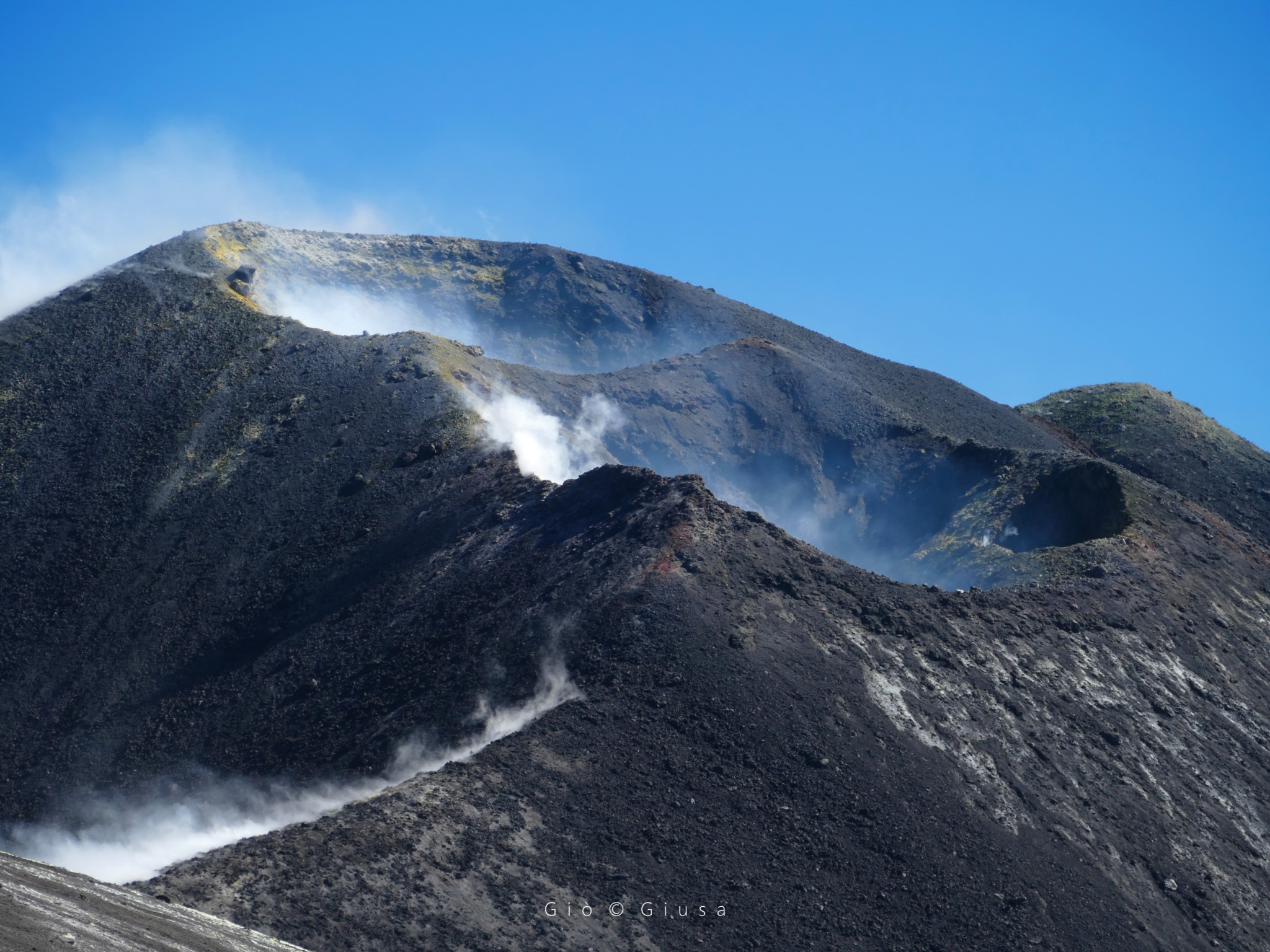
Source : INGV.
Photo : Gio Giusa .
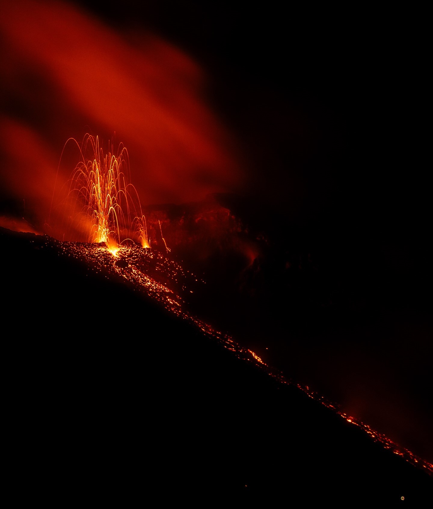
Italy , Stromboli :
WEEKLY BULLETIN, November 24, 2025 to November 30, 2025. (Publication date: December 2, 2025)
ACTIVITY SUMMARY
Based on monitoring data, the following points should be noted:
1) VOLCANOLOGICAL OBSERVATIONS: During this period, ordinary Strombolian-type eruptive activity was observed, with ejecta and lava flow from the North Crater area. The total hourly frequency fluctuated between high values (16 and 24 events/hour). The intensity of the explosions was mostly low to medium in the North and Central-South Crater areas.
2) SEISMOLOGY: The monitored seismic parameters showed no significant variations.
3) GROUND DEFORMATION: The ground deformation monitoring networks did not detect any significant variations.
4) GEOCCHEMISTRY: Average SO₂ flux.
High CO₂ flux from the ground in the Pizzo area (STR02).
C/S ratio in the pen: Average.
Dissolved helium isotope ratio (R/Ra) in the thermal aquifer: Very high values (data from 05/11/2025).
CO₂ flux from the ground in the San Bartolo area: Very high values.
CO₂ flux from the ground in the Scari area: Average values.
5) SATELLITE OBSERVATIONS: Satellite-observed thermal activity in the summit area was generally moderate, with a few isolated high-level anomalies corresponding to the eruptive activity of November 29, 2025.
VOLCANOLOGICAL OBSERVATIONS
During the observation period, Stromboli’s eruptive activity was characterized by the analysis of images recorded by the INGV-OE monitoring cameras located at 190 m (SCT-SCV) and at Punta dei Corvi (SPCT). Explosive activity was primarily produced by five eruptive vents located in the North Crater area and by at least two vents located in the Central-South area.
A lava flow was observed on November 29 in the North Crater area.
Observations of explosive activity captured by the monitoring cameras:
Five active winds were observed in the North Crater area (N), two in sector N1 and three in sector N2, producing explosive activity of low (less than 80 m high) and medium intensity (less than 150 m high). The eruptive products were primarily composed of coarse material (bombs and lapilli). In addition, lava ejection activity was observed in sectors N1 and N2, becoming intense at times in sector N1 on November 24, 26, 28, and 29. The average explosion frequency ranged from 16 to 21 events per hour. In the Central-South (CS) crater area, two main vents were observed, exhibiting explosions of fine material mixed with coarse material of low to medium intensity. The average explosion frequency ranged from zero to 4 events per hour.
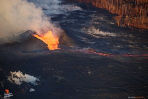
Lava flow of November 29, 2025
On November 29, starting at 00:35 UTC, following intense lava ejection from vents in sector N2 of the northern part of the North Crater, a lava flow began and spread into the Sciara del Fuoco, reaching its central section. After a few hours, the flow appeared to slow and the liquid began to cool.
Source : INGV
Photo : Stromboli stati d’animo / Sebastiano Cannavo
Colombia , Puracé – Los Coconucos volcanic chain :
Popayán, December 2, 2025, 8:30 a.m.
Regarding the monitoring of activity in the Los Coconucos volcanic chain, the Geological Survey of Colombia (SGC), an agency under the Ministry of Mines and Energy, reports the following:
Since the publication of yesterday’s extraordinary bulletin and up to the date of this bulletin, seismic signals related to fluid movements, including tremors (TR) and long-period (LP) shaking, have been recorded beneath the Puracé volcano crater and are associated with the continuous emission of volcanic gases into the atmosphere. Some of these signals were accompanied by small ash emissions, the dispersal of which was primarily influenced by variations in wind patterns.
The observed gas and ash plumes reached heights exceeding 500 meters, but it is impossible to calculate their total height using the camera network installed in the volcano’s sphere of influence due to adverse weather conditions. During the period covered by this bulletin, seven alerts were issued to civil aviation authorities. The most notable of these alerts was issued on December 1st at 11:27 PM, corresponding to a volcanic tremor signal associated with a column of gas and ash that reached an altitude of over 500 meters above the summit of Mount Puracé and dispersed to the southeast. Similarly, a report was received yesterday at 10:30 AM from the village of Pululó concerning a change in the color of the San Francisco River, which turned brown. This change is likely related to the washing away of ash accumulated on the upper slopes of the volcano by recent rains.
Furthermore, a report of ashfall was received from the village of San Juan de Puracé at 2:00 PM. As long as the orange alert level remains in effect, temporary fluctuations in volcanic activity are possible. This means that activity may sometimes decrease compared to previous days or weeks, without necessarily indicating a return to a stable level. A reasonable amount of time is needed to return to a more stable level (yellow alert) in order to assess all monitored parameters and determine trends that would indicate reliable stabilization.
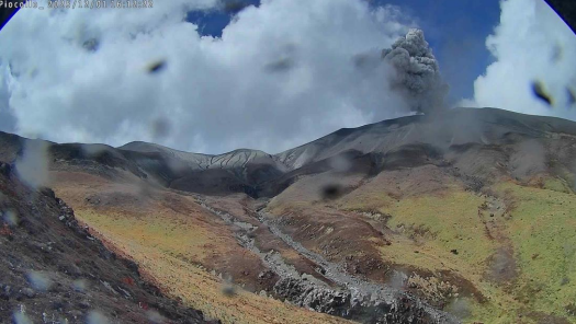
Recording from the Piocollo camera located 1.6 km southeast of the Puracé volcano. Gas and ash plume recorded at 11:12 a.m. on December 1, 2025, at a height of over 500 m above the summit of the Puracé volcano.
Geological Service of Colombia (SGC) recommends staying away from the volcano’s crater and surrounding areas, closely monitoring the situation through special bulletins and other information published on our official channels, and following the instructions of local and regional authorities and the National Unit for Disaster Risk Management (UNGRD). The volcanic activity level remains at orange alert: volcano exhibiting significant variations in monitored parameters.
Source et photo : SGC.
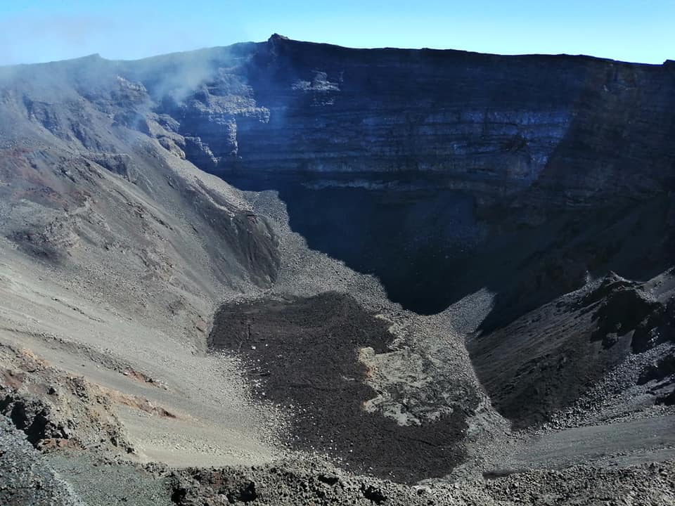
La Réunion Island , Piton de la Fournaise :
Observations
In November 2025, the OVPF-IPGP recorded the following at the Piton de la Fournaise massif:
• 350 shallow volcano-tectonic earthquakes (0 to 2.5 km above sea level) beneath the summit craters;
• 24 deep earthquakes (below sea level);
• 26 long-period earthquakes;
• 277 rockfalls.
The deep seismicity recorded beneath the Plaines region since mid-September 2025 continued in November. These events, located at a depth of approximately 20 km, indicate persistent activity in the deep transfer zone, consistent with deep magma movement.
Between November 22 and 26, deep seismicity also occurred at a depth of approximately 5 km beneath the northern rim of the summit of Piton de la Fournaise. In total, 26 deep volcano-tectonic earthquakes were recorded during this period. The magnitudes remained very low, and the intensity of this sequence was significantly lower than that observed during the deep reactivations of 1998 and 2015 in the same area.
Between November 24 and 26, this deep activity was accompanied by the occurrence of several long-period (LP) events, possibly reflecting degassing or fluid circulation processes within the magmatic system. A total of 24 LP events were detected.
Starting on November 26, a significant increase in shallow seismicity was recorded along the ring fault located above the shallow magma reservoir. The number of shallow volcano-tectonic events increased sharply over the following days:
11/26: 17 events,
11/27: 21 events,
11/28: 58 events,
11/29: 75 events,
11/30: 165 events.
This increase reflects a progressive acceleration of seismic activity beneath the summit area, consistent with a possible pressurization of the shallow reservoir.
Numerous (277) landslides in the Dolomieu crater, at the level of the ramparts of the Enclos Fouqué and at the Cassé de la Rivière de l’Est were also recorded as in previous months.
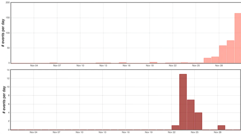
Histogram showing the number of shallow (top) and deep (bottom) volcano-tectonic earthquakes per day recorded in November 2025
Balance sheet
Between April 2024 and November 2025, magma replenishment and pressurization of the shallow reservoir had ceased.
In November 2025, a reactivation of the shallow magmatic system was observed. Since November 22, 2025, an increase in seismicity beneath the summit area of the volcano has been recorded. This sequence was initially marked by deep seismicity beneath the northern rim of the Dolomieu crater (4–5 km depth). From November 24, this deep activity was accompanied by the occurrence of several long-period (LP) events, and then, from November 26, by an increase in shallower seismicity, to a depth of approximately 2 km below the summit. This seismic activity is accompanied by a slight increase in sulfur concentrations in the atmosphere at the volcano’s summit, and since the end of November by a resumption of inflation of the edifice, the source of which is located at a depth of approximately 2.5 km.
It should be noted that this pressurization process of the shallow reservoir can last from several days to several weeks before the reservoir roof ruptures, thus resulting in an injection of magma towards the surface and potentially an eruption, but it can also cease without leading to an eruption in the short term.
Source : OVPF.
Photos : Nath Duverlie , OVPF-IPGP .