June 30 , 2026.
Italy / Sicily , Etna :
Statement on Mount Etna activity, June 29, 2026, 20:40 (18:40 UTC)
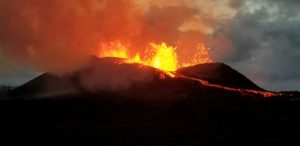
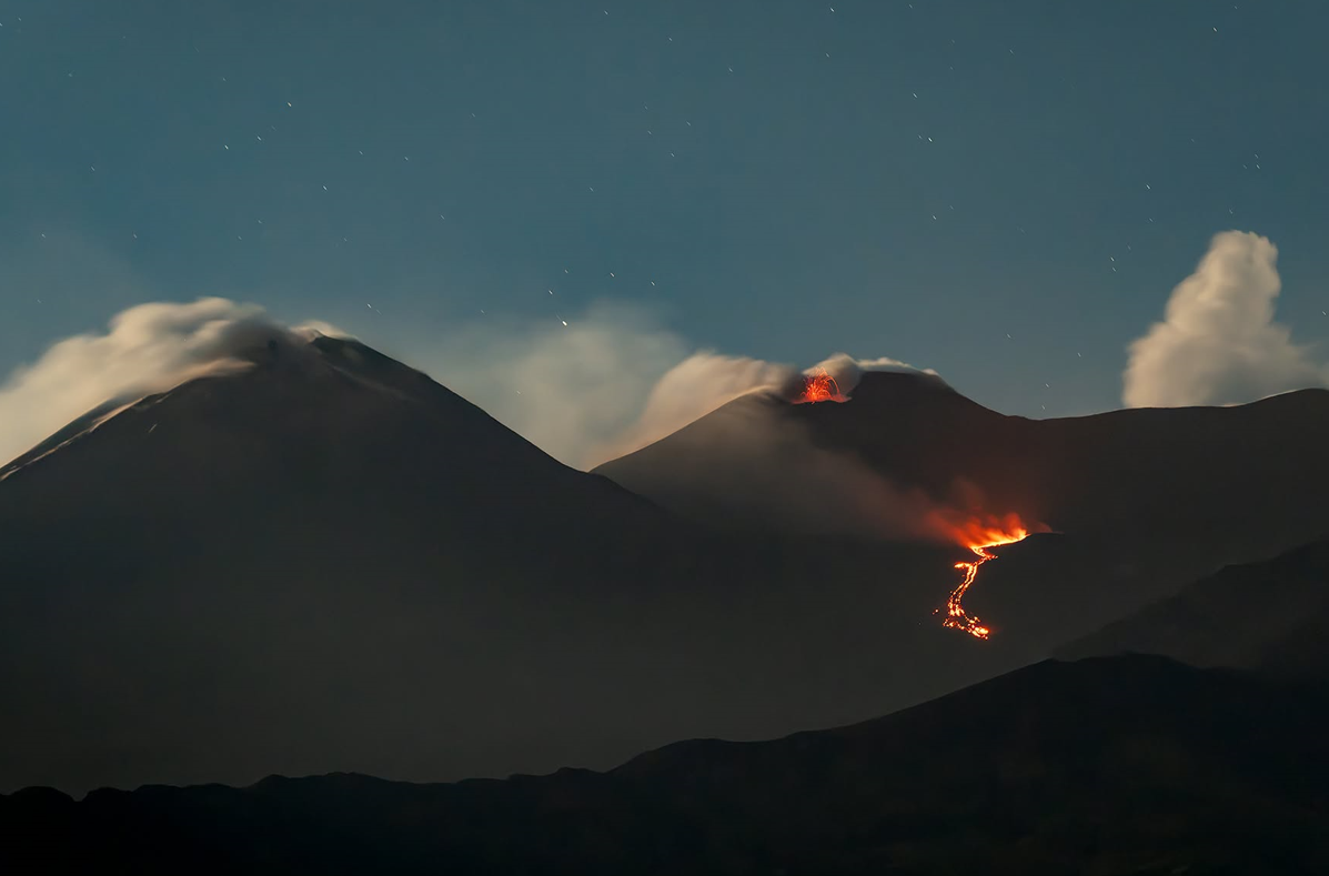
The National Institute of Geophysics and Volcanology (INGV) – Etna Observatory – reports that, based on field observations by INGV personnel, effusive activity is continuing, fed by an eruptive vent located at an elevation of 3,030 m; the leading edge of the lava flow is currently situated at an estimated elevation of between 2,750 and 2,700 m. Since the last update on June 27, no explosive activity has been observed at the Voragine crater.
Over the past 48 hours, the average amplitude of volcanic tremor has remained stable at moderate levels. The centroid of the tremor sources remains located in the area
of the Voragine crater, at an elevation of approximately 3,000 meters above sea level.
Infrasonic activity is currently at a moderate level—in terms of both the number of events and energy—with sources located at the Northeast Crater.
No significant variation has been detected in the time series from ground deformation monitoring stations.
Further updates will be provided in due course.
Source : INGV.
Photo : Massimo Tamajo Fotografo Naturalista / FB.
Indonesia , Ili Lewotolok :
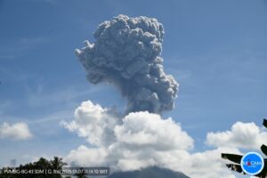
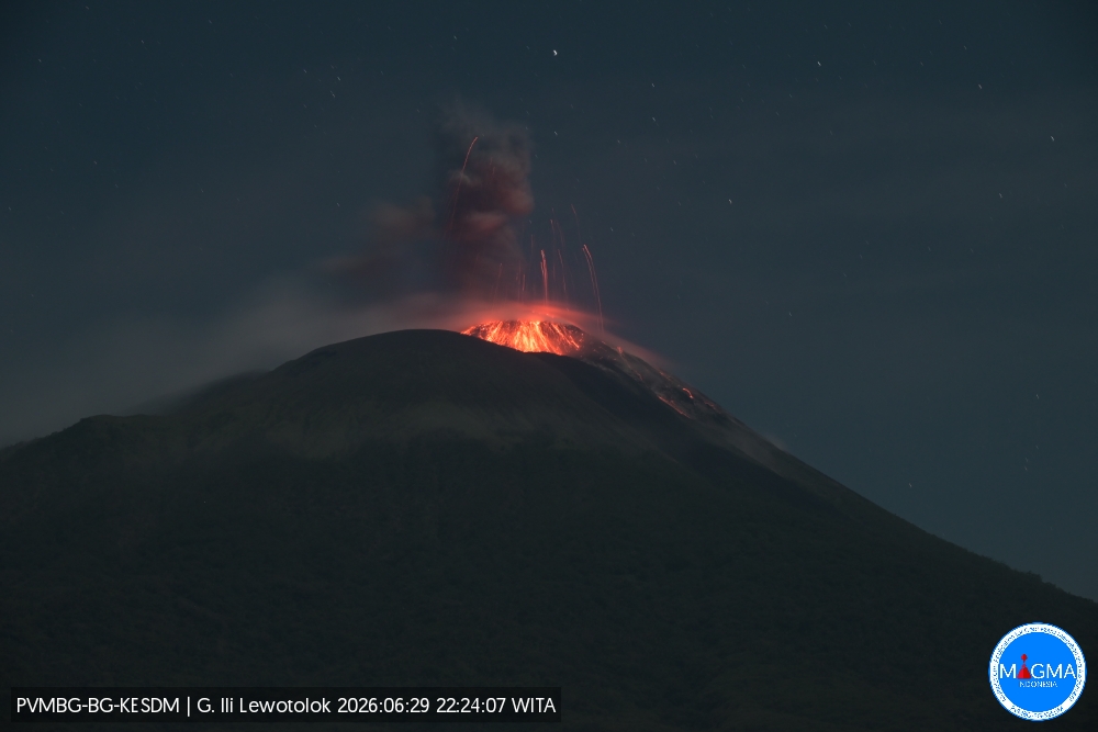
An eruption of Mount Ili Lewotolok occurred on Monday, June 29, 2026, at 10:24 PM (WITA), with an ash column reaching a height of approximately 500 m above the summit (or about 1,923 m above sea level). The observed ash column was gray, of moderate to high density, and drifted towards the northwest. The eruption was recorded by the seismograph with a maximum amplitude of 33.2 mm and a duration of 42 seconds.
VOLCANO OBSERVATORY NOTICE FOR AVIATION – VONA
Issued : June 29 , 2026 .
Volcano : Ili Lewotolok (264230)
Current Aviation Colour Code : ORANGE
Previous Aviation Colour Code : orange
Source : Ili Lewotolok Volcano Observatory
Notice Number : 2026LEW020
Volcano Location : S 08 deg 16 min 19 sec E 123 deg 30 min 18 sec
Area : East Nusa Tenggara, Indonesia
Summit Elevation : 4554 FT (1423 M)
Volcanic Activity Summary :
Eruption with volcanic ash cloud at 14h24 UTC (22h24 local).
Volcanic Cloud Height :
Best estimate of ash-cloud top is around 6154 FT (1923 M) above sea level or 1600 FT (500 M) above summit. May be higher than what can be observed clearly. Source of height data: ground observer.
Other Volcanic Cloud Information :
Ash cloud moving to northwest. Volcanic ash is observed to be gray. The intensity of volcanic ash is observed from medium to thick.
Remarks :
Eruption recorded on seismogram with maximum amplitude 33.2 mm and maximum duration 42 second.
Source et photo : PVMBG.
Hawaii , Kilauea :
HAWAIIAN VOLCANO OBSERVATORY DAILY UPDATE , U.S. Geological Survey
Monday, June 29, 2026, 8:58 AM HST (Monday, June 29, 2026, 18:58 UTC)
19°25’16 » N 155°17’13 » W,
Summit Elevation 4091 ft (1247 m)
Current Volcano Alert Level: ADVISORY
Current Aviation Color Code: YELLOW
Summary:
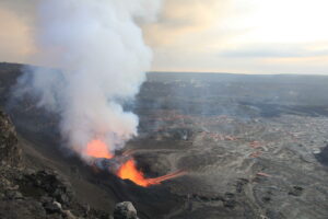
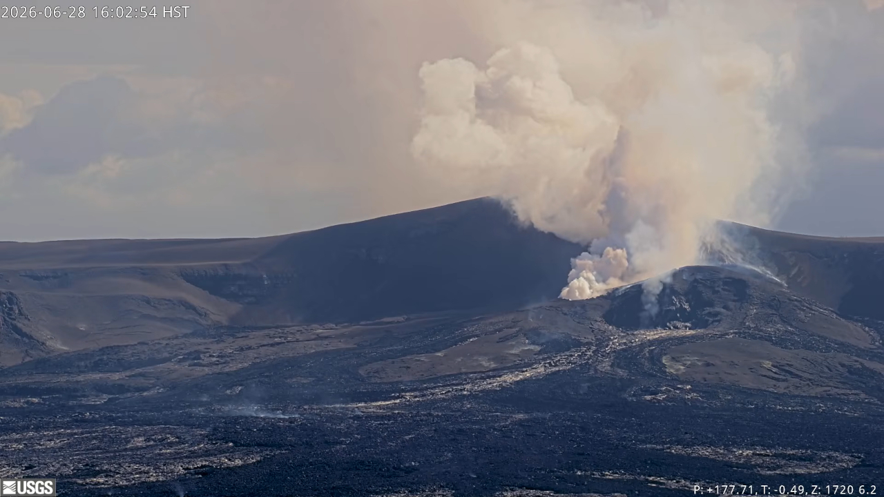
Kīlauea volcano is not erupting; the summit eruption in Halemaʻumaʻu is paused. Episode 50 ended at 5:10 p.m. HST on June 27. Re-inflation indicates another episode is likely between July 6 and July 12, more data are needed to refine the forecast.
Overview:
The summit eruption of Kīlauea in Halemaʻumaʻu is paused following 7 hours of lava fountaining during episode 50 on June 27, 2026. Inflation measured by tiltmeters around the summit of Kīlauea resumed after episode 50 ended accompanied by continued glow from both vents, suggesting that another episode is likely. Forecast models indicate that the onset of fountaining episode 51 will likely be between July 6 and July 12; however, this forecast is based on preliminary data and may change in the coming days.
No significant activity has been noted along Kīlauea’s East Rift Zone or Southwest Rift Zone.
Summit Observations:
Bright glow and flames were visible from the south vent in Halemaʻumaʻu overnight, with intermittent glow and flames visible from the north vent. Only a few bright spots of incandesence were visible on the floor of Halemaʻumaʻu overnight, lava flows within the crater and around the vents appear to have stagnated.
Low-frequency seismic pulsing began with the cessation of episode 50 and continues this morning, which is typical during the onset of pauses between eruptive episodes. There were no earthquakes within Kaluapele (Kīlauea caldera) in the past 24 hours.
Kīlauea summit deflation totaled 15.3 microradians during episode 50. Once the episode ended, inflation resumed and has since recovered 4.0 microradians of tilt at the summit tiltmeter at Uēkahuna (UWD).
The sulfur dioxide (SO2) emission rate from the summit is likely now varying within a typical range of 1,000 to 5,000 tonnes per day.
Rift Zone Observations:
Rates of seismicity and ground deformation remain low in the East Rift Zone and Southwest Rift Zone. SO2 emissions from the East Rift Zone remain below the detection limit.
Source et photo : HVO.
Ecuador , Sangay :
DAILY STATUS REPORT FOR SANGAY VOLCANO, Monday, June 29, 2026.
Information from the Geophysical Institute – EPN.
Surface activity level: Moderate; Surface trend: Unchanged
Internal activity level: Moderate; Internal trend: Unchanged
Seismicity: From June 28, 2026, 11:00 AM to June 29, 2026, 11:00 AM:
Seismicity:
Due to data transmission issues, it was not possible to count seismic events using the reference station.
Precipitation / Lahars:
Precipitation was recorded in the volcano area, though it did not trigger mud or debris flows. **In the event of heavy rain, accumulated material could be remobilized, generating mud and debris flows that would descend the volcano’s flanks and spill into adjacent watercourses.**
Emission plume / ash:
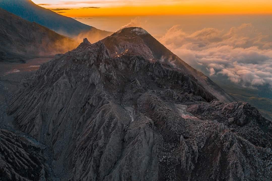
No gas or ash emissions were observed via the camera monitoring system or satellite imagery. Furthermore, the Washington VAAC reported no visible emissions associated with the volcano’s activity.
Observation:
From yesterday afternoon until the time of writing this report, the volcano remained partially visible.
Alert level: Yellow
Source : IGEPN
Photo : Volcan Sangay / FB.
Guatemala , Santiaguito :
Weather conditions: Clear
Wind: East/Northeast
Precipitation: 15.5 mm
Activity
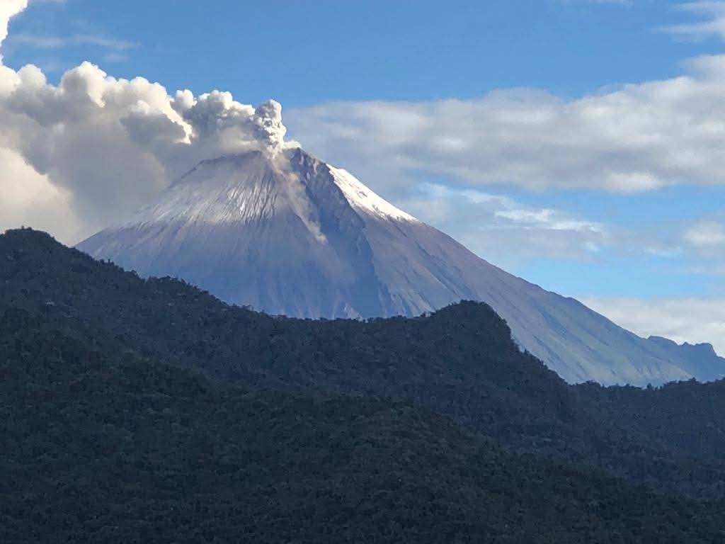
The Santiaguito volcanic complex remains active; the extrusion of volcanic material from the crater and the advance of a lava flow are causing a continuous descent of block and volcanic material avalanches down the southwest flank. Some of these avalanches transform into pyroclastic flows that reach the base of the dome, keeping ash suspended over the central part of the volcanic complex. Low- to moderate-intensity explosions are being recorded, generating ash plumes that reach up to 3,200 meters above sea level and disperse toward the west and southwest over a distance of approximately 20 km.
This activity is causing ashfall in the communities of Loma Linda and San Marcos Palajunoj, as well as in other surrounding areas. Incandescence was observed in the crater during the night and early morning, confirming the presence of active magmatic material at the surface. Due to the persistent instability of the dome, there is a risk of partial collapses that could generate pyroclastic flows capable of traveling greater distances. Consequently, it is recommended to avoid approaching the lava domes or entering and remaining in the ravines of the volcanic complex, as these areas pose the greatest danger regarding such phenomena.
Source : Insivumeh.
Photo : Noticias Caballo Blanco