August 9 , 2026.
Italy / Sicily , Etna :
Update on Mount Etna activity, August 8, 2026, 11:32 (09:32 UTC).
The National Institute of Geophysics and Volcanology (INGV) – Etna Observatory reports a pyroclastic flow observed by field personnel between Mount Simone and Mount Rittmann.
Update on Mount Etna activity, August 8, 2026, 12:14 (10:14 UTC).
The National Institute of Geophysics and Volcanology (INGV) – Etna Observatory reports that a new eruptive vent opened around 09:30 UTC in the Valle del Bove, at an elevation of 2,550 m, near Monte Rittmann. INGV teams are currently conducting field surveys, the results of which will be released as soon as possible.
Regarding seismic activity, tremor amplitude has shown a slight, gradual decrease over the past 24 hours, while remaining within a high range. Tremor sources remain located near the Voragine crater, at an elevation of approximately 3,000 meters above sea level.
During the same period, infrasonic activity remained moderate in terms of both the number and amplitude of events; the sources are located at the Voragine crater.
The GNSS and tiltmeter monitoring networks show no significant variations. The summit stations of the tiltmeter network continue to record the change in trend that began on August 6 and was previously reported.
Statement on Mount Etna activity, August 8, 2026, 18:10 (16:10 UTC).
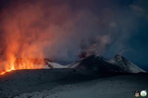
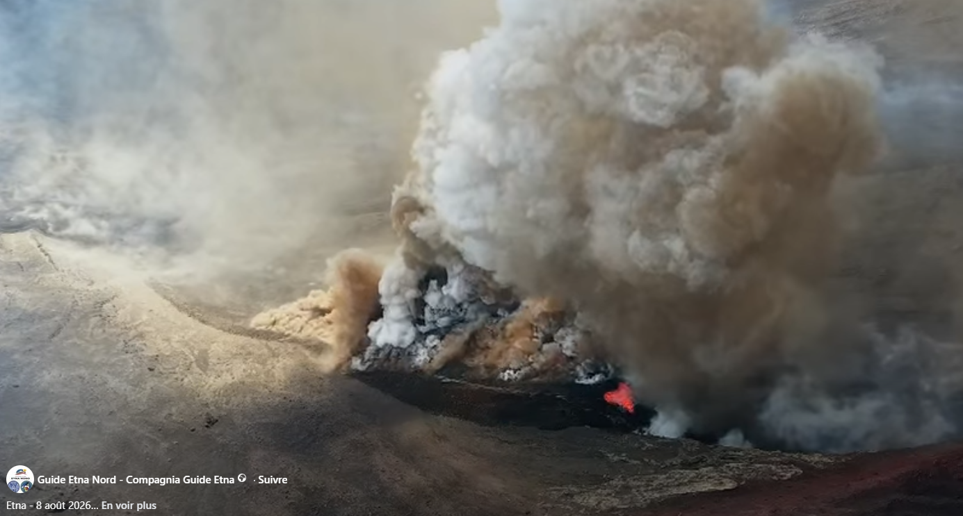
The National Institute of Geophysics and Volcanology (INGV) – Osservatorio Etneo – reports that field inspections by INGV personnel and analysis of video surveillance images indicate the continuation of intense explosive activity at the Voragine crater today, characterized by alternating phases of high and low intensity. The explosions originate from at least three eruptive vents located between the Voragine crater and the Southeast Crater.
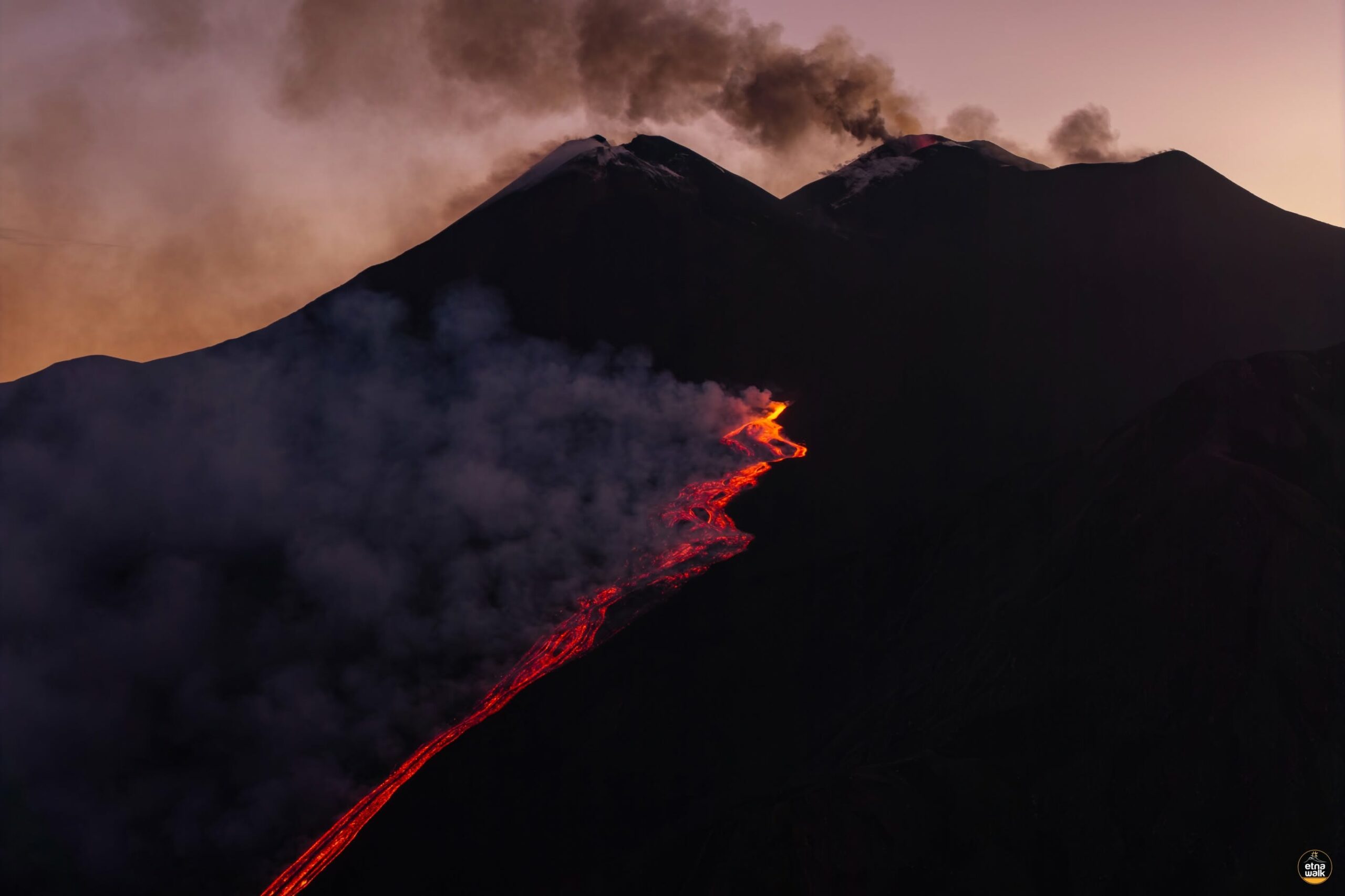
The eruptive vent that appeared on the 7th in the Valle del Leone (at an elevation of approximately 2,750 m) remains active and is feeding a complex lava field; its active front, after passing Monte Simone, reached an elevation of approximately 1,850 m around 10:30 UTC. Finally, at 09:28 UTC, a new eruptive vent opened in the Valle del Bove, near Monte Rittmann, at an elevation of 2,360 m. This event was accompanied by the formation of two small pyroclastic flows, triggered by the collapse and rapid mobilization of loose material dislodged during the vent’s formation. The latter produced a lava field whose advancing front reached an elevation of approximately 2,100 m around 11:00 UTC.
Seismically, volcanic tremor remains at a high level, localized at the Voragine crater at an elevation of approximately 3,000 m above sea level. Infrasonic events show a slight increase in both number and energy and are localized at the Voragine crater.
GNSS and tiltmeter monitoring networks show no significant variations. However, summit stations in the tiltmeter network continue to record the trend change that began on August 6 and was previously reported. The maximum variation, approximately 5.7 microradians, was detected at the Cratere del Piano (ECP) station.
Further information will be provided as soon as possible.
Source : INGV.
Photos : Etna Walk / Giuseppe Distefano / Marco Restivo , Guides etna Nord , Capture d’écran .
Alaska , Iliamna :
ALASKA VOLCANO OBSERVATORY INFORMATION STATEMENT, U.S. Geological Survey
Saturday, August 8, 2026, 11:03 AM AKDT (Saturday, August 8, 2026, 19:03 UTC)
60°1’55 » N 153°5’30 » W,
Summit Elevation 10016 ft (3053 m)
Current Volcano Alert Level: NORMAL
Current Aviation Color Code: GREEN
Summary:
An avalanche signal observed in seismic and pressure sensor data. No volcanic activity.
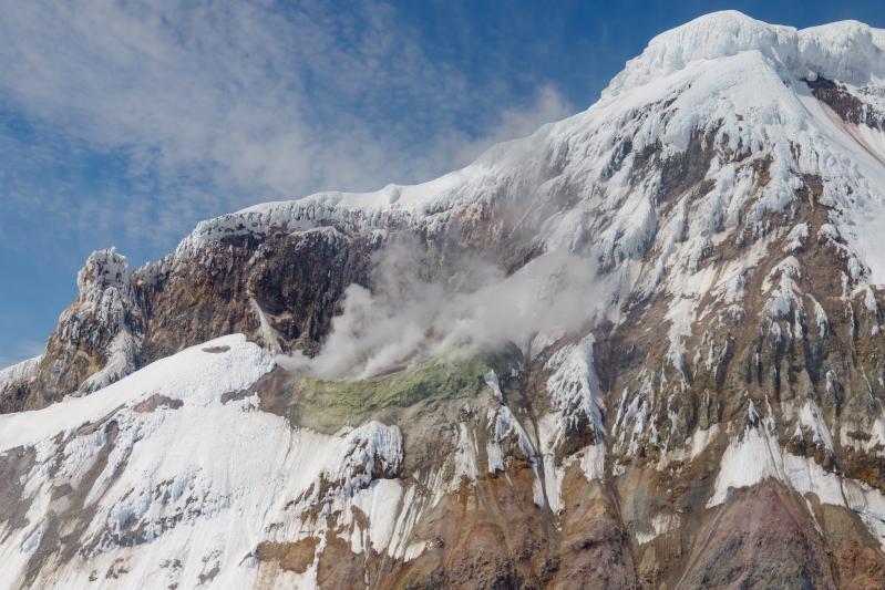
AVO detected seismic and pressure sensor signals associated with a large avalanche on the eastern flank of Iliamna Volcano this morning at 7:57 am AKDT (15:57 UTC). Avalanche events are somewhat common at this volcano. Avalanches of similar seismic duration and amplitude occurred previously on May 22, 2016, June 21, 2019 and June 6, 2023. The seismic signals from the avalanche were observed on monitoring networks throughout the Cook Inlet and as distant as the Katmai region 250 km (155 miles) away. We have not received any visual observations of the slide location or extent. The avalanche is not considered to be indicative of volcanic unrest.
Iliamna volcano is located on the western side of lower Cook Inlet in Lake Clark National Park. It is a snow-covered stratovolcano which rises 3046 meters (9,993 feet) above sea level. Although steam plumes occur on its eastern flanks, there has been no historical volcanic activity at Iliamna. Iliamna is located 215 kilometers (130 miles) southwest of Anchorage and 100 kilometers (60 miles) northwest of Homer.
Source : AVO.
Photo : Mota, Rui / AVO / USGS.
Indonesia , Semeru :
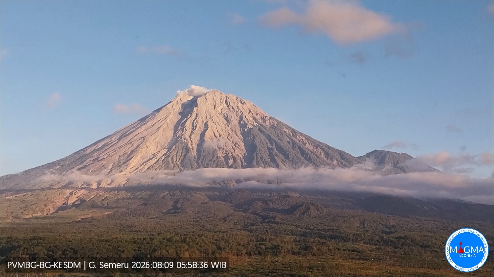
An eruption of Mount Semeru occurred on Sunday, August 9, 2026, at 05:58 WIB; the observed ash column rose approximately 400 m above the summit (or about 4,076 m above sea level). This column, of moderate intensity and white to gray in color, was drifting southwest. At the time of writing, the eruption was still ongoing.
Seismic observations
32 eruption earthquakes, with amplitudes of 10–22 mm and durations of 59–147 seconds.
2 avalanche earthquakes, with amplitudes of 3–4 mm and durations of 45–76 seconds.
6 emission earthquakes, with amplitudes of 3–6 mm and durations of 31–39 seconds.
3 harmonic tremors, with amplitudes of 2–4 mm and durations of 215–322 seconds.
1 distant tectonic earthquake, with an amplitude of 14 mm and a duration of 71 seconds.
Recommendations
1. Do not conduct any activities in the southeast sector along the Besuk Kobokan River within a 13 km radius of the summit (eruption center). Beyond this distance, the public must not conduct activities within 500 meters of the banks of the Besuk Kobokan, due to the risk of pyroclastic flows and lahars extending up to 17 km from the summit.
Source et photo : PVMBG.
Ecuador , El Reventador :
DAILY STATUS REPORT FOR REVENTADOR VOLCANO, Saturday, August 8, 2026.
Information: Geophysical Institute – EPN.
Surface activity level: High; Surface trend: Unchanged
Internal activity level: Moderate; Internal trend: Unchanged
From August 7, 2026, 11:00 to August 8, 2026, 11:00:
Seismicity:
Explosion (EXP): 63
Long-period (LP): 10
Emission tremor (TREMI): 10
Harmonic tremor (TRARM): 9
Precipitation / Lahars:
No precipitation was recorded in the area. **Heavy rains could remobilize accumulated materials and generate debris-laden mudflows (lahars) capable of descending the volcano’s flanks and flowing into adjacent rivers.**
Emission plume / ash:
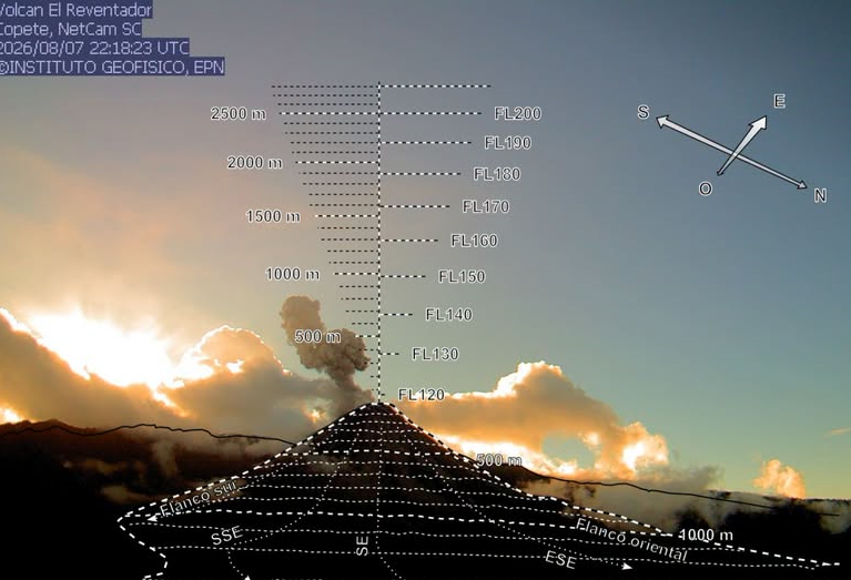
Camera observations revealed several gas and ash emissions reaching altitudes of 800 to 1,000 meters above the crater rim, moving towards the southwest. In connection with this activity, the Washington VAAC issued three reports noting ash emissions reaching 700 meters above the crater rim, with plumes drifting towards the west-southwest and west.
Other monitoring parameters:
The MIROVA-MODIS satellite system detected a thermal anomaly.
Observation:
From yesterday afternoon until the time of writing this report, the volcano remained largely obscured by cloud cover. However, during the night and early morning, cameras captured incandescent material descending to a level 1,000 meters below the crater rim.
Alert Level – SGR: Orange
Source et photo : IGEPN.
Colombia , Puracé – Los Coconucos volcanic chain :
Popayán, August 8, 2026, 2:00 PM.
Based on monitoring of the Los Coconucos volcanic chain’s activity, the Colombian Geological Service (SGC)—an agency attached to the Ministry of Mines and Energy—
reports the following:
Since the last bulletin was published, seismic activity linked to fluid dynamics within the volcanic conduits has continued to dominate seismic records—
specifically continuous tremor (TR) and long-period (LP) events; these phenomena remain localized beneath the Puracé volcano crater, at depths of less than 1 km.
Seismicity associated with rock fracturing has remained at a very low level, in terms of both frequency and magnitude, occurring between 1 and 2 km beneath the crater.
Between 2:00 PM yesterday and the time this bulletin was issued, six ash emission events were recorded; notable among these were the event yesterday, August 7, at 5:57 PM and the one this morning at 9:12 AM. Both events were confirmed by webcams monitoring surface activity, as well as by residents of various rural communities in Puracé and Coconuco and the city of Popayán.
Additionally, reports of ashfall have been received from the town center of Coconuco, the rural communities of Cristales and Cobaló (located in the same municipality), and the city of Popayán.
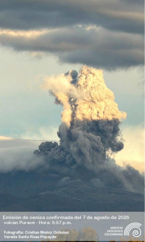
Photograph of the ash emission that occurred at 5:57 PM on August 7, 2026, taken from the rural community of Santa Rosa in the municipality of Popayán.
The values recorded by instruments on the volcano in recent days are the highest observed to date, significantly exceeding usual baseline levels; they indicate a major shift in volcanic dynamics, and the volcano remains at the orange alert level.
While the orange alert level remains in effect, temporary fluctuations in volcanic activity may occur—with activity sometimes decreasing compared to previous days or weeks—but this does not necessarily mean the volcano has returned to a stable state. Downgrading to the yellow alert level requires a sufficient period to evaluate all monitored parameters and identify trends indicating reliable stability.
The public is advised not to approach the crater areas of the Puracé, Piocollo, and Curiquinga volcanoes, as sudden ash or gas emissions posing a significant risk to people could occur.
In light of the above, the SGC recommends closely monitoring the evolution of this phenomenon through daily bulletins and other information released via our official channels, as well as adhering to instructions from local and departmental authorities and the National Unit for Disaster Risk Management (UNGRD). The volcanic alert level remains orange: a volcano showing significant changes in monitored parameters.
Source et photo : SGC.