July 2 , 2026.
Kamchatka , Mutnovsky :
KVERT VOLCANIC ACTIVITY NOTICE (VAN)
Issued: 20260701/2146Z
Volcano: Mutnovsky (CAVW #300060)
Current aviation colour code: ORANGE
Previous aviation colour code: green
Source: KVERT
Notice Number: 2026-58
Volcano Location: N 52 deg 27 min E 158 deg 12 min
Area: Kamchatka, Russia
Summit Elevation: 2323 m (7619.44 ft)
Volcanic Activity Summary:
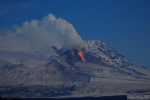
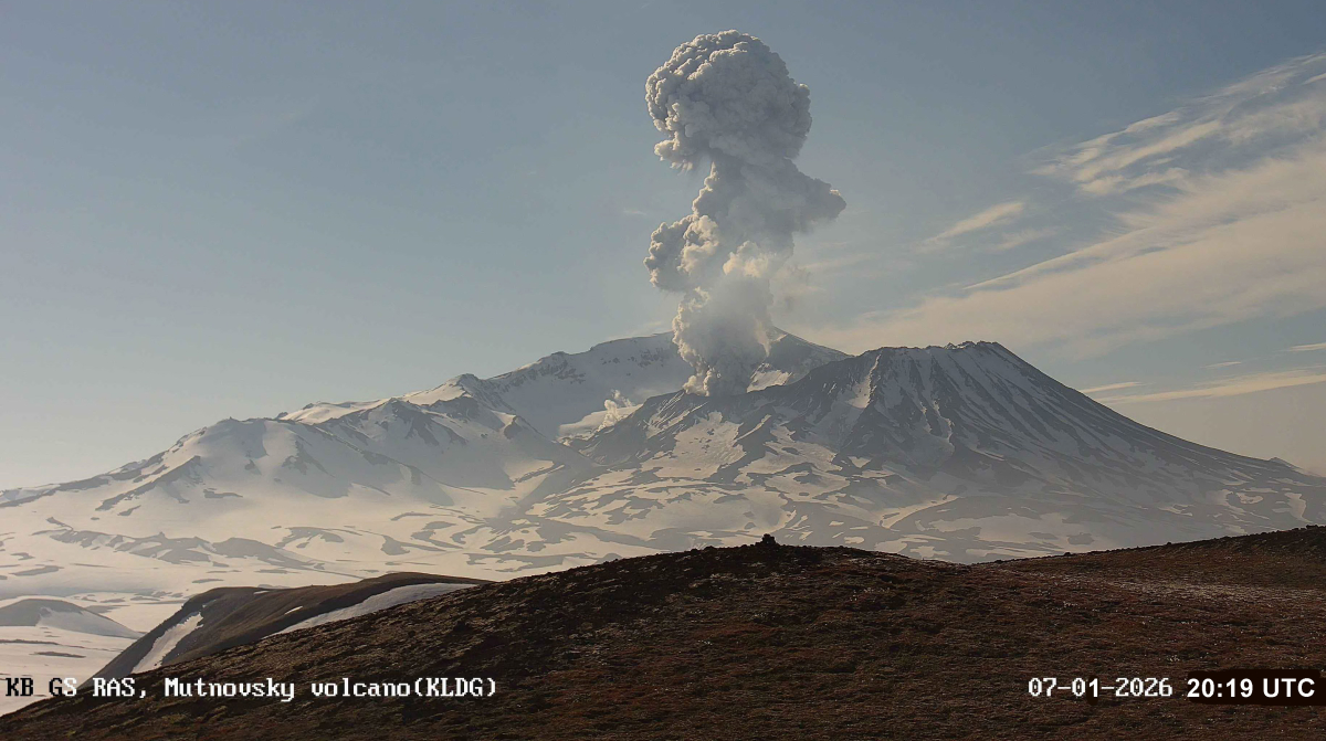
An ash explosion up to 3.5 km a.s.l. occurred on Mutnovsky volcano on 08:19 UTC June 01, ash plume extended several kilometers to the west from the volcano.
An activity of the volcano continues. Ongoing activity could affect low-flying aircraft.
Volcanic cloud height:
3500 m (11480 ft) AMSL Time and method of ash plume/cloud height determination: 20260701/2019Z – Video data
Other volcanic cloud information:
Distance of ash plume/cloud of the volcano: 10 km (6 mi)
Direction of drift of ash plume/cloud of the volcano: W
Time and method of ash plume/cloud determination: 20260701/2019Z – Video data
Start time of explosion and how determined: 20260701/2019Z – Video data
Duration of explosion: ~ 3 min
Remarks:
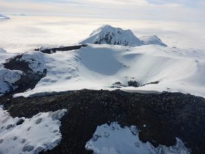
The volcano is located in the south of Kamchatka, 70 km southwest of Petropavlovsk-Kamchatsky. Last weak eruption occurred on July 3, 2013.
Source : Kvert.
Photo : KB GS RAS.
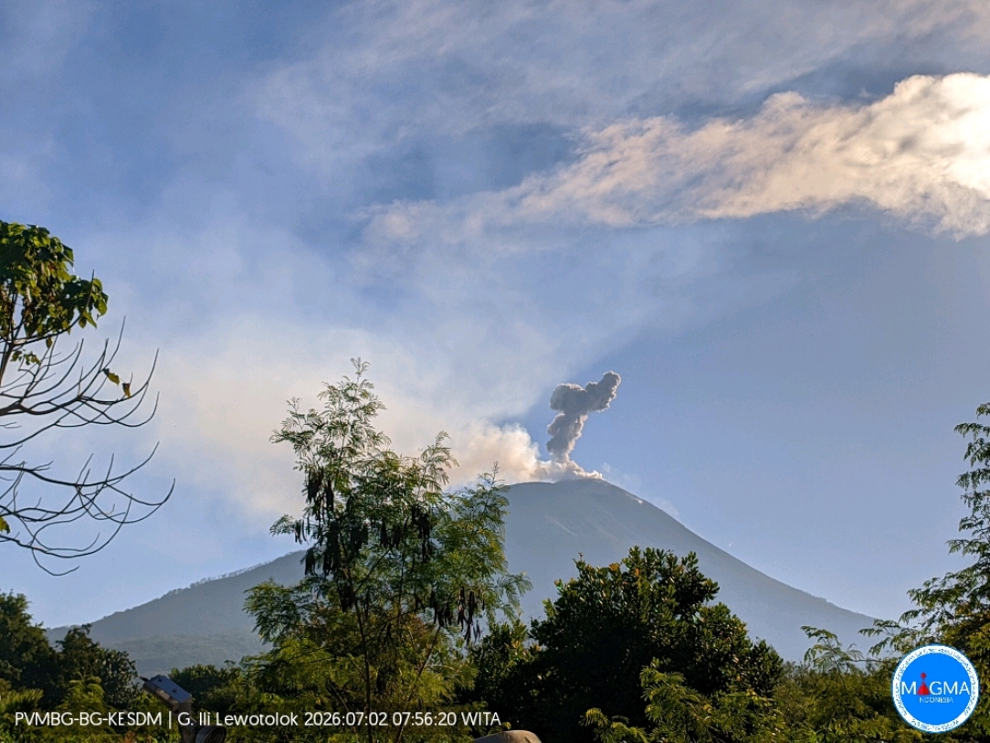
Indonesia , Ili Lewotolok :
An eruption of Mount Ili Lewotolok occurred on Thursday, July 2, 2026, at 07:55 WITA, producing an ash column estimated to reach approximately 600 m above the summit (or about 2,023 m above sea level). The observed ash column was gray and dense, drifting toward the southeast. The eruption was recorded by a seismograph with a maximum amplitude of 40 mm and a duration of 54 seconds.
Seismic observations
78 eruption earthquakes, with amplitudes of 8.8–40 mm and durations of 37–86 seconds.
3 avalanche earthquakes, with amplitudes of 2.8–11.1 mm and durations of 31–61 seconds.
58 emission earthquakes, with amplitudes of 3.3–27.6 mm and durations of 18–53 seconds.
1 harmonic tremor, with an amplitude of 4.4 mm and a duration of 136 seconds.
1 shallow volcanic earthquake, with an amplitude of 40 mm and a duration of 18 seconds.
5 deep volcanic earthquakes, with amplitudes of 4.4–11.1 mm and durations of 8–13 seconds.
1 distant tectonic earthquake, with an amplitude of 16.6 mm and a duration of 58 seconds.
Recommendations
1. Communities living near Mount Ili Lewotolok, as well as visitors, climbers, and tourists, are advised not to enter or conduct activities within a 2 km radius of the Mount Ili Lewotolok activity center.
2. Remain vigilant regarding potential risks of lava avalanches and pyroclastic flows in the southern, southeastern, western, and northeastern sectors of Mount Ili Lewotolok.
Source et photo : PVMBG.
Colombia , Puracé – Los Coconucos volcanic chain :
Popayán, June 30, 2026, 12:00 PM.
Based on monitoring of the Puracé–Los Coconucos volcanic chain, the Colombian Geological Service (SGC)—an agency attached to the Ministry of Mines and Energy—reports the following:
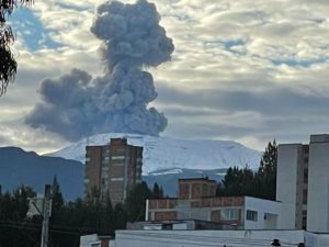
During the week of June 23 to 29, 2026, behavior similar to that recorded the previous week was observed. Seismic activity associated with fluid movement (gases and liquids derived from magma and their interaction with the hydrothermal system) persists beneath the Puracé volcano crater, at depths of less than 3 km.
The number of daily ash emissions decreased, and the associated plumes dispersed toward the northwest, reaching a maximum height of 1 km above the volcano’s summit.
Meanwhile, seismicity associated with rock fracturing (VT) remained comparable to the previous week in terms of both frequency and released seismic energy. These earthquakes were primarily located between the Puracé and Piocollo volcanoes, at depths ranging from 1 to 3 km, with magnitudes below 1.
Images captured by webcams (visible and infrared spectrum) continued to show thermal anomalies at the fumarole field located on the outer rim of the Puracé volcano crater, as well as degassing phenomena at the craters of the Puracé and Curiquinga volcanoes.
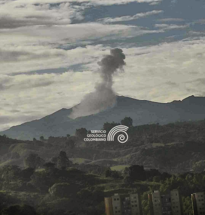
Footage from the observatory camera, located 28 km northwest of Puracé volcano, showing an ash emission on June 24, 2026, at 7:42 a.m.
Atmospheric sulfur dioxide (SO2) emissions are also continuing. The slow deformation process previously recorded in the area between the Puracé, Piocollo, and Curiquinga volcanoes persists.
In conclusion, the variations observed at Puracé volcano—part of the Los Coconucos volcanic chain—indicate that the system continues to evolve;
further ash emissions and fallout are possible, with dispersion determined by prevailing wind directions. Furthermore, further changes in volcanic activity that could lead to more energetic surface manifestations cannot be ruled out. The public is advised not to visit the upper reaches of the volcanic chain and to stay informed via official SGC reports.
The volcanic alert level remains at « Yellow »: an active volcano showing changes in the baseline behavior of monitored parameters, as well as other manifestations.
Source et photo : SGC.
Hawaii , Kilauea :
HAWAIIAN VOLCANO OBSERVATORY DAILY UPDATE , U.S. Geological Survey
Wednesday, July 1, 2026, 7:48 AM HST (Wednesday, July 1, 2026, 17:48 UTC)
19°25’16 » N 155°17’13 » W,
Summit Elevation 4091 ft (1247 m)
Current Volcano Alert Level: ADVISORY
Current Aviation Color Code: YELLOW
Summary:
Kīlauea volcano is not erupting. Forecasts based on summit inflation indicate another lava fountaining episode is likely between July 7 and 14.
Overview:
The summit eruption of Kīlauea in Halemaʻumaʻu is paused following lava fountaining episode 50 on June 27, 2026. Tiltmeters began measuring summit reinflation immediately after the episode ended, and glow has been visible from both eruptive vents in overnight webcam views, indicating that another lava fountaining episode is likely. However, reinflation has slowed over the past day, probably delaying the onset of the next episode. Current forecast models suggest that lava fountaining episode 51 will occur sometime between July 7 and 14.
No significant activity has been noted along Kīlauea’s East Rift Zone or Southwest Rift Zone.
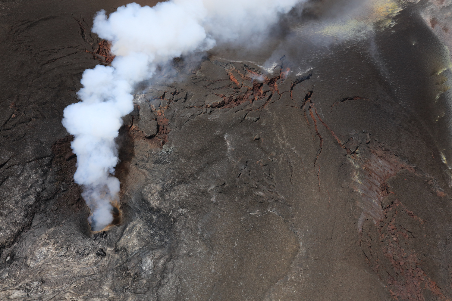
View looking down the north vent, taken during a USGS Hawaiian Volcano Observatory monitoring overflight on June 30, 2026. Glow and flames have been intermittently seen since episode 50 of lava fountaining in Halema‘uma‘u ended on June 27, 2026, but no glow was observed from the north or south vents during the overflight. The gas plume was robust and obscured good views into the vent conduits.”
Summit Observations:
Moderate to bright glow was continuously visible from the south vent overnight, while weak glow was intermittently visible from the north vent.
Low-frequency seismic pulsing has continued over the past day. There were 10 small-magnitude (below M2.0) earthquakes beneath southern Kaluapele (Kīlauea caldera) in a small flurry yesterday morning, but summit earthquake activity has diminished since then.
Kīlauea summit deflation totaled 15.3 microradians on the Uēkahuna (UWD) tiltmeter during lava fountaining episode 50. Once the episode ended, inflation resumed, but it has slowed over the past day. As of this morning, UWD has recovered 5.2 microradians of tilt since episode 50.
The sulfur dioxide (SO2) emission rate from the summit is likely now varying within a typical range of 1,000 to 5,000 tonnes per day.
Rift Zone Observations:
Rates of seismicity and ground deformation remain low in the East Rift Zone and Southwest Rift Zone. SO2 emissions from the East Rift Zone remain below the detection limit.
Source : HVO.
Photo : USGS / D. Downs
Guatemala , Fuego :
Weather conditions: Clear skies
Wind: East/Northeast
Precipitation: 1.8 mm
Activity
Volcán de Fuego continues to exhibit constant explosive activity of the Strombolian and Vulcanian types—ranging from low or moderate to strong—accompanied by gas and ash plumes reaching altitudes between 4,200 and 4,700 meters above sea level. These plumes are dispersing toward the west and southwest, extending approximately 30 km from the crater. The activity is accompanied by avalanches of incandescent blocks and volcanic material cascading down the volcano’s western, southern, and southwestern flanks. Ashfall has also been reported in the communities of Santa Sofía, El Porvenir, San Pedro Yepocapa, Sangre de Cristo, and other surrounding areas. The most energetic explosions generate rumbling sounds and shockwaves that are perceptible in neighboring municipalities and communities.
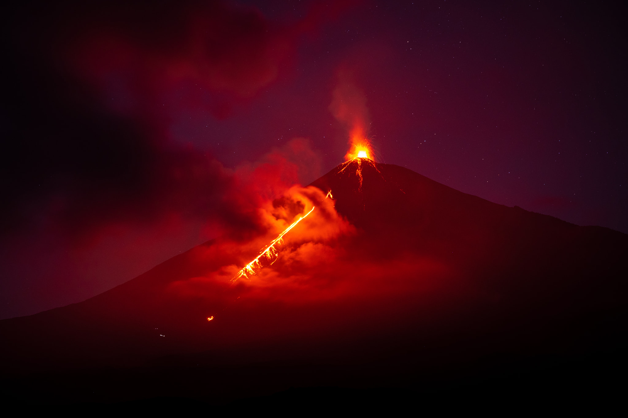
Sounds resembling those of a locomotive have also been reported, occurring at intervals of 3, 5, or 10 minutes. Current activity levels pose a high risk on the plateau and in the immediate vicinity of the crater due to the ejection of ballistic material, which can travel more than 500 meters from the crater. Consequently, remaining in or traveling through these areas is not advised. Those climbing the volcano are advised to wear clothing and use equipment suitable for high-mountain conditions, given the low temperatures in the area and the likelihood of precipitation during the afternoon and night.
Source : Insivumeh.
Photo : Diego Rizzo .