June 26 , 2026.
Japan , Asosan :
The Japan Meteorological Agency (JMA) reported that the amplitude of volcanic tremors at Asosan began to increase at around 09h00 on 21 June and reached a high level, signaling increasing unrest; the amplitude decreased around three hours later. During a field survey that same day scientists measured a high sulfur dioxide emission rate of 1,700 tons per day (t/d), increased from 900 t/d on 16 June. White plumes rose as high as 800 m above the Nakadake Crater rim. At 16h00 the Alert Level was raised to 2 (on a scale of 1-5) and the public was warned that eruptive products may impact areas within 1 km of the crater. The amplitude of volcanic tremors increased at around 01h50 on 22 June and was followed by an ejection of material visible in webcam images that fell back into the crater and a white plume rising 600 m above the crater rim.

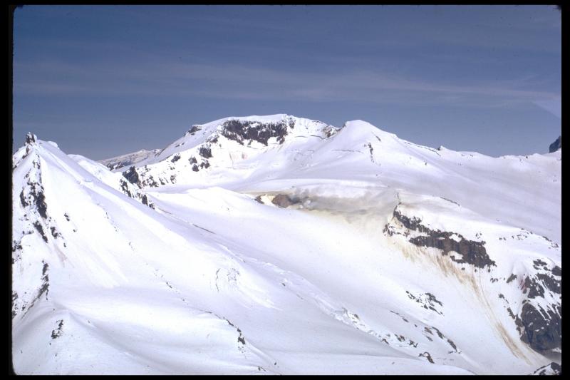
The 24-km-wide Asosan caldera was formed during four major explosive eruptions from 300,000 to 90,000 years ago. These produced voluminous pyroclastic flows that covered much of Kyushu. The last of these, the Aso-4 eruption, produced more than 600 km3 of airfall tephra and pyroclastic-flow deposits. A group of 17 central cones was constructed in the middle of the caldera, one of which, Nakadake, is one of Japan’s most active volcanoes. It was the location of Japan’s first documented historical eruption in 553 CE. The Nakadake complex has remained active throughout the Holocene. Several other cones have been active during the Holocene, including the Kometsuka scoria cone as recently as about 210 CE. Historical eruptions have largely consisted of basaltic to basaltic andesite ash emission with periodic strombolian and phreatomagmatic activity. The summit crater of Nakadake is accessible by toll road and cable car, and is one of Kyushu’s most popular tourist destinations.
Sources: Japan Meteorological Agency (JMA) , GVP.
Photo : GVP.
Japan , Tokachidake :
The Japan Meteorological Agency (JMA) reported intensifying unrest at Tokachidake. Deformation data recorded persistent inflation at shallow depths starting in March. Seismicity near Crater 62-2 began increasing in April with spikes in the number of events occasionally occurring in May and June. Field surveys conducted on 28 April and 10 June revealed sulfur dioxide emission rates of 1,200 and 1,400 tons per day, respectively; these levels were higher than those in March. Beginning in April monitoring webcams recorded faint incandescence from Crater 62-2, possibly from high-temperature gas emissions and the combustion of sulfur. During 16-17 June field visits scientists observed high-temperature volcanic gas rising from the 62-2 Crater and the Furiko-sawa fumarole area; the fumarolic area had expanded and was releasing a larger volume of gases. They also observed repeated ejections of hot, muddy water from a part of the crater floor. At 11h00 on 18 June the Alert Level was raised to 2 (on a scale of 1-5) and the public was warned that eruptive products may impact areas within 1.5 km of the crater.
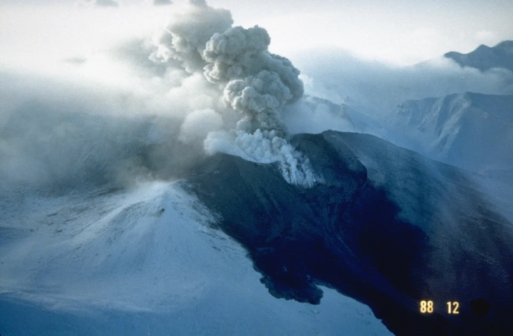
Tokachidake volcano consists of a group of dominantly andesitic stratovolcanoes and lava domes arranged on a NE-SW line above a plateau of welded Pleistocene tuffs in central Hokkaido. Numerous explosion craters and cinder cones are located on the upper flanks of the small stratovolcanoes, with the youngest Holocene centers located at the NW end of the chain. Frequent historical eruptions, consisting mostly of mild-to-moderate phreatic explosions, have been recorded since the mid-19th century. Two larger eruptions occurred in 1926 and 1962. Partial cone collapse of the western flank during the 1926 eruption produced a disastrous debris avalanche and mudflow.
Sources: Japan Meteorological Agency (JMA), GVP.
Photo : GVP.
Alaska , Kupreanof :
The Alaska Volcano Observatory (AVO) reported that unrest at Kupreanof continued through 24 June characterized by gas emissions, seismic activity, and deformation. Shallow seismicity remained at elevated levels with more than 30 earthquakes of magnitudes of 1 or greater detected since 12 May, when the Alert Level was first raised. The largest events during the current phase of unrest, which began in February, occurred on 15 and 16 June and had magnitudes of 3.2 and 3.6, respectively. Sulfur dioxide emissions were detected in satellite data on 13 days during 12 May-22 June with calculated emission rates of 100-800 tons per day, similar to the rate of emissions detected since April. These elevated emission rates were consistent with degassing of new, relatively shallow, magma beneath the volcano.
Satellite interferometric radar (InSAR) ground deformation data was collected in mid-June following sufficient snow melt. A comparison with data from 30 September 2025, before snow covered the area, indicated that ground uplift around the volcano occurred sometime in the past eight months. The source depth of the inflation signal was estimated at 6 km below sea level, consistent with a magmatic intrusion and in agreement with the seismic and gas data. The Volcano Alert Level remained at Advisory (the second level on a four-level scale) and the Aviation Color Code remained at Yellow (the second color on a four-color scale).
Source: US Geological Survey Alaska Volcano Observatory (AVO), GVP.
Photo : Miller, T. P. Alaska Volcano Observatory / Geophysical Institute.
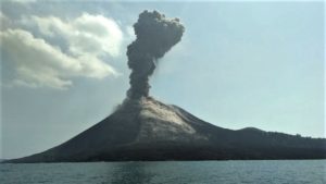
Indonésia , Lewotobi Laki-laki :
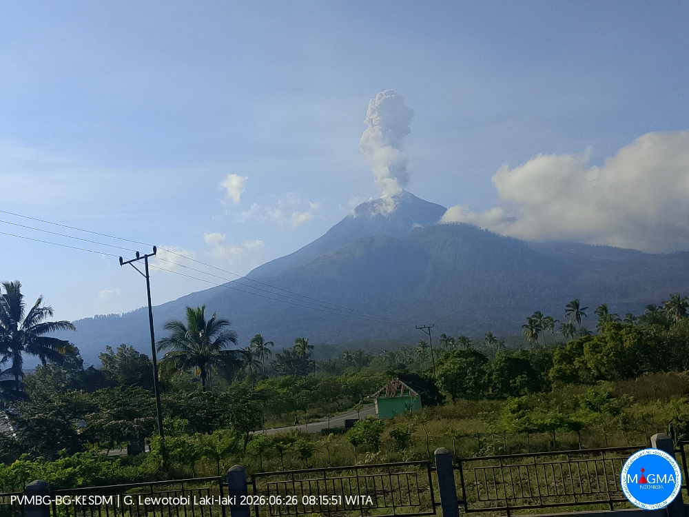
An eruption of Mount Lewotobi Laki-laki occurred on Friday, June 26, 2026, at 08:14 WITA; the observed ash column reached a height of approximately 1,200 meters above the summit (or about 2,784 meters above sea level). This dense, gray ash column drifted toward the west and northwest. The eruption was recorded by a seismograph with a maximum amplitude of 47.3 mm and a duration of 49 seconds.
VOLCANO OBSERVATORY NOTICE FOR AVIATION – VONA
Issued : June 26 , 2026
Volcano : Lewotobi Laki-laki (264180)
Current Aviation Colour Code : ORANGE
Previous Aviation Colour Code : orange
Source : Lewotobi Laki-laki Volcano Observatory
Notice Number : 2026LWK119
Volcano Location : S 08 deg 32 min 20 sec E 122 deg 46 min 06 sec
Area : East Nusa Tenggara, Indonesia
Summit Elevation : 5069 FT (1584 M)
Volcanic Activity Summary :
Eruption with volcanic ash cloud at 00h14 UTC (08h14 local).
Volcanic Cloud Height :
Best estimate of ash-cloud top is around 8909 FT (2784 M) above sea level or 3840 FT (1200 M) above summit. May be higher than what can be observed clearly. Source of height data: ground observer.
Other Volcanic Cloud Information :
Ash cloud moving from west to northwest. Volcanic ash is observed to be gray. The intensity of volcanic ash is observed to be thick.
Remarks :
Eruption recorded on seismogram with maximum amplitude 47.3 mm and maximum duration 49 second.
Source et photo : PVMBG.
Philippines , Kanlaon :
The Philippine Institute of Volcanology and Seismology (PHIVOLCS) reported continuing eruptive activity at Kanlaon during 17-24 June. The seismic network recorded 1-9 daily volcanic earthquakes; on 17 June the counts included four periods of volcanic tremor lasting 18-43 minutes. Sulfur dioxide emissions ranged from 1,152 to 3,418 tonnes per day. Volcanic emissions generally rose as high as 900 m above the summit and drifted WSW and SW; weather clouds obscured views on 23 June.
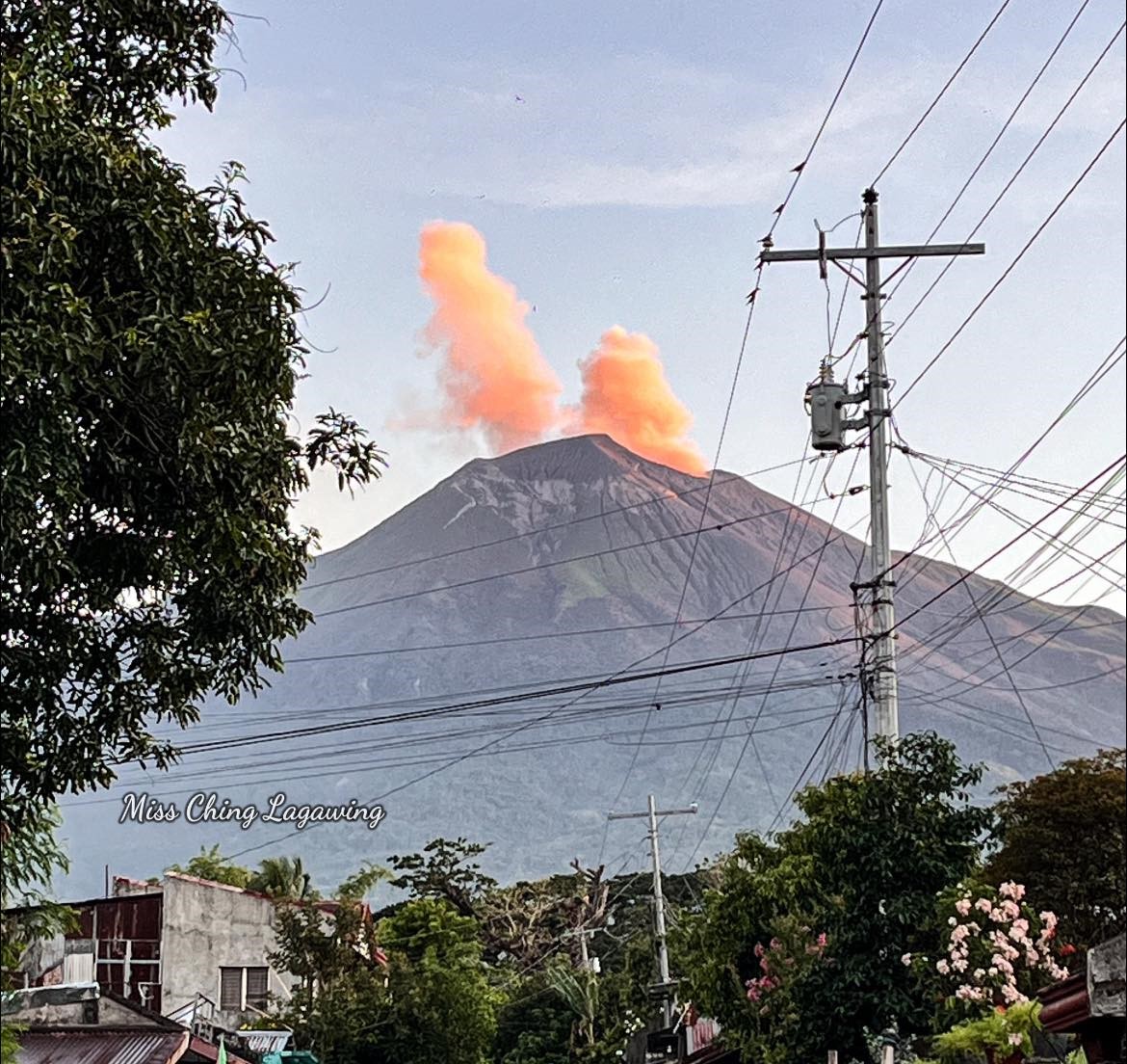
There were 2-3 daily periods of ash emissions during 17 and 19-20 June, each lasting as short as five minutes to as long as one hour and 22 minutes. Specifically, the webcam recorded grayish ash emissions at 03h32 and 05h35 on 19 June rising 300 m above the crater rim and drifting SW. The Alert Level remained at 2 (on a scale of 0-5); the public was warned to stay out of the 4-km-radius Permanent Danger Zone (PDZ) and pilots were advised to avoid flying close to the summit.
Sources: Philippine Institute of Volcanology and Seismology (PHIVOLCS) , GVP.
Photo : Miss Ching Lagawing