April 30 , 2026.
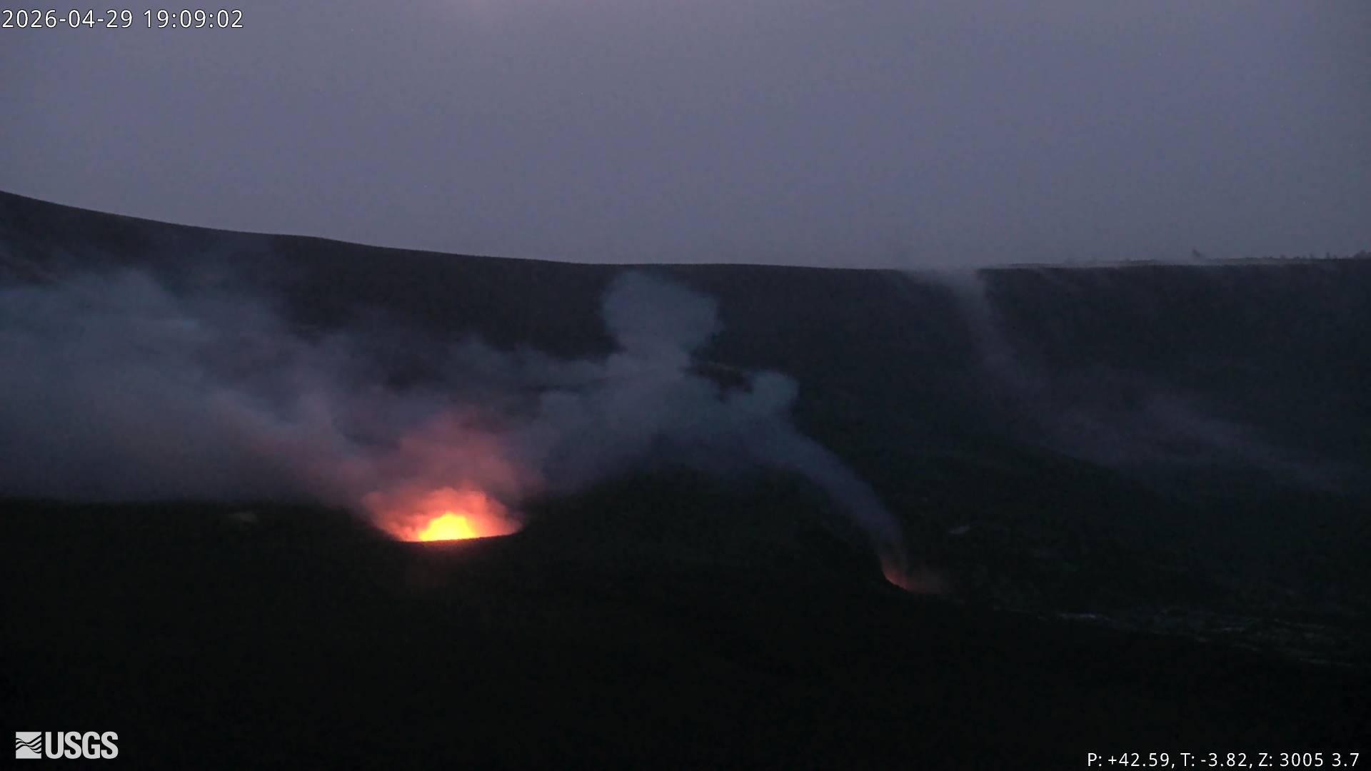
Hawaii , Kilauea :
HAWAIIAN VOLCANO OBSERVATORY DAILY UPDATE , U.S. Geological Survey
Wednesday, April 29, 2026, 9:30 AM HST (Wednesday, April 29, 2026, 19:30 UTC)
19°25’16 » N 155°17’13 » W,
Summit Elevation 4091 ft (1247 m)
Current Volcano Alert Level: ADVISORY
Current Aviation Color Code: YELLOW
Overview:
The eruption at the summit of Kīlauea is currently paused. The forecast window for episode 46, based on tilt data, suggests that lava fountaining will occur again sometime between Sunday, May 3 and Thursday, May 7. This window may be adjusted based on continuing observations.
No significant activity has been noted along Kīlauea’s East Rift Zone or Southwest Rift Zone.
Summit Observations:
Consistent glow was observed from both vents on webcams overnight, although glow was significantly brighter in the south vent. Both vents produced occasional flames, likely caused by the ignition of volcanic gases escaping the vent.
Seismic tremor continues with regular pulses and earthquake activity at the summit increased over the past day, with 96 small earthquakes recorded (all less than 2.0M), primarily within Halemaʻumaʻu crater and south/southwest of the caldera.
During episode 45, the Uēkahuna tiltmeter (UWD) recorded about 16.0 microradians of deflationary tilt. Currently, UWD is recording slight deflationary tilt, but since the end of episode 45, UWD has recorded a total of 9.0 microradians of inflationary tilt. Fluctuations in tilt are normal during eruptive pauses.
With the eruption now paused, the SO2 emission rate is likely varying within a typical range of 1,000 to 5,000 tonnes per day.
Rift Zone Observations:
Rates of seismicity and ground deformation remain low in the East Rift Zone and Southwest Rift Zone. SO2 emissions from the East Rift Zone remain below the detection limit.
Source et photo : HVO
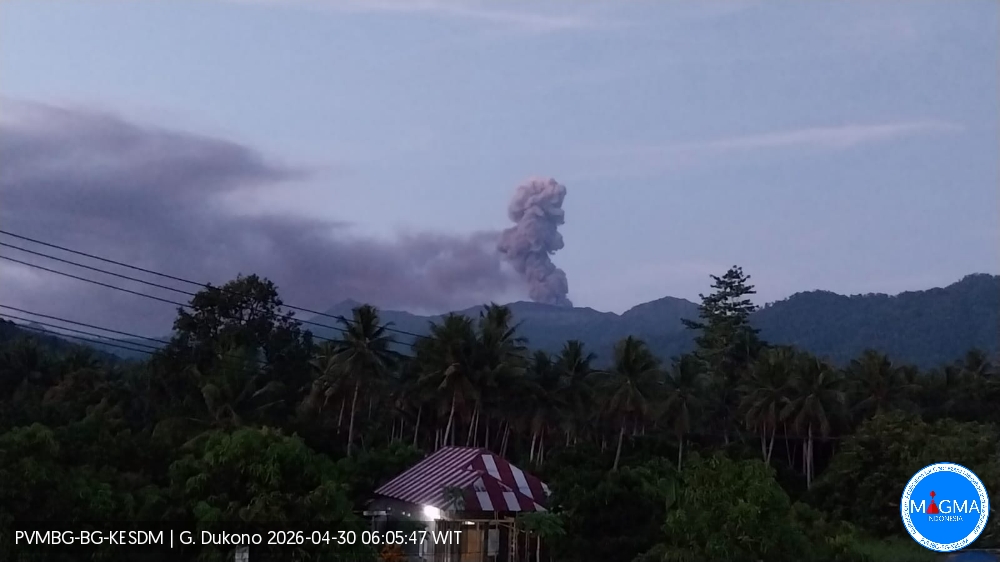
Indonesia , Dukono :
An eruption of Mount Dukono occurred on Thursday, April 30, 2026, at 05:59 WIT, with an observed ash column height of approximately 1200 m above the summit (approximately 2287 m above sea level). This ash column was white to gray in color, highly intense, and directed northeast. The eruption was recorded by a seismograph, with a maximum amplitude of 25 mm and a duration of 48.04 seconds.
Seismic Observations
87 eruption earthquakes with amplitudes ranging from 6 to 34 mm and durations from 33.53 to 108.88 seconds.
5 distant tectonic earthquakes with amplitudes ranging from 12 to 34 mm and durations from 66.48 to 88.01 seconds.
1 continuous seismic tremor with amplitudes ranging from 1 to 6 mm, primarily 2 mm.
Recommendations
(1) Residents living near Mount Dukono and visitors/tourists are advised to refrain from any activity, climbing, or approaching the Malupang Warirang crater within a 4 km radius.
(2) Considering that eruptions with volcanic ash occur periodically and that the distribution of ash follows the direction and speed of the wind, so that the area where the ash lands is not constant, people living around Mount Dukono are advised to always carry masks/face coverings and mouth coverings to use when needed to avoid the threat that volcanic ash poses to the respiratory system.
Source et photo : PVMBG.
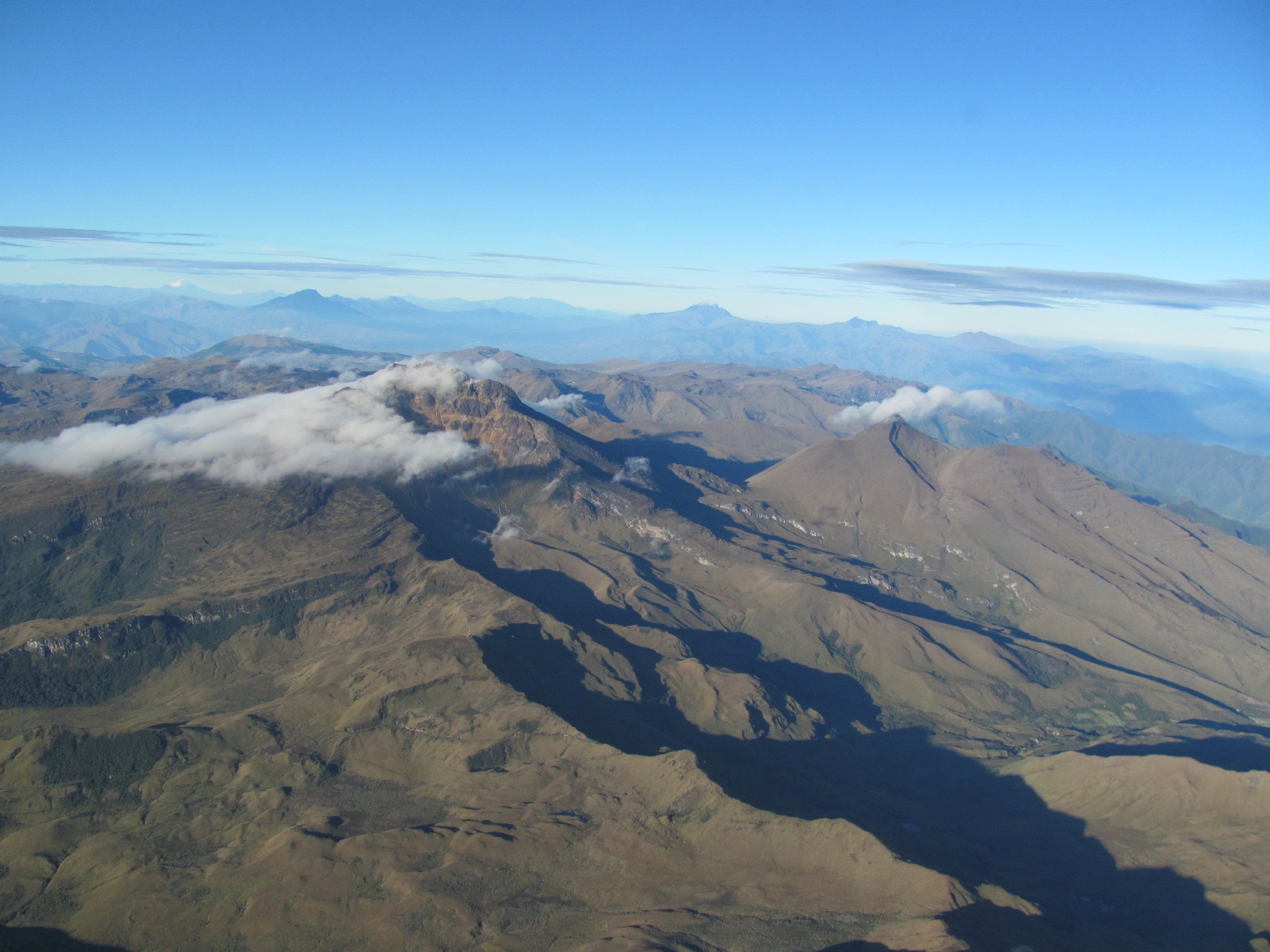
Colombia , Chiles / Cerro Negro :
San Juan de Pasto, April 28, 2026, 7:00 PM
Regarding the monitoring of activity at the Chiles-Cerro Negro Volcanic Complex (CVCCN), the Colombian Geological Survey (SGC), an agency under the Ministry of Mines and Energy, reports the following:
For the period from April 21 to 27, 2026, the main variations in monitored parameters, compared to the previous week, were as follows:
● Seismic activity did not show significant variations; the frequency and energy released remained similar. The magnitude of the strongest earthquake was 2.5, and its epicenter was located 4 km below the summit of the Chiles volcano. In general, seismic activity extended from the collapse zone of Chiles Volcano to approximately 3 km south, at depths between 1 and 5 km below the summit of Chiles Volcano (4,700 m altitude). No earthquakes were felt. Furthermore, seismicity related to fluid movement continues to be recorded, with some events being transient and others persistent.
● Recording of volcanic deformation variations, measured by satellite sensors and ground stations in the area of influence of these volcanoes, continues.
Based on the assessment and correlation of monitored parameters, the Geological Survey of Colombia (SGC) recommends closely monitoring developments through weekly bulletins and other information published via its official channels, as well as following instructions from local and departmental authorities and the National Unit for Disaster Risk Management (UNGRD).
Volcanic activity remains at the yellow alert level: Active volcano with changes in the baseline behavior of monitored parameters and other manifestations.
Source et photo : SGC.
Chile , Laguna del Maule :
SPECIAL REPORT ON VOLCANIC ACTIVITY, April 28, 2026
The Argentine Geological and Mining Service (SEGEMAR), through its Argentine Volcanic Monitoring Observatory (OAVV), reports that today, Tuesday, April 28, 2026, at 6:19 a.m. local time (9:19 a.m. UTC), volcanic monitoring stations located near the Laguna del Maule volcanic complex recorded a volcano-tectonic (VT) seismic event associated with rock fracturing within the volcanic system.
Event Information:
Origin Time: 6:19 a.m. local time (9:19 a.m. UTC)
Latitude: -36.103°
Longitude: -70.484°
Depth: 4.3 km
Local Magnitude: 3.2 (ML)
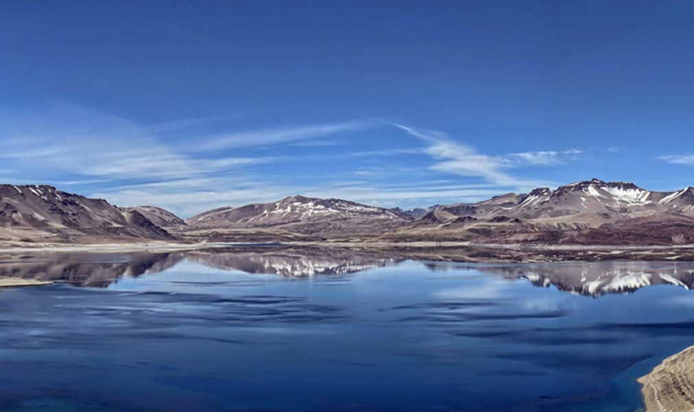
OBSERVATIONS:
No surface activity or variation in other monitoring parameters was detected at the volcanic complex. This event had no impact on Argentine territory, and no reports were received from neighboring populations in Argentina.
CONCLUSIONS:
The technical alert level remains in effect, and monitoring of the volcano continues in constant communication with the Southern Andes Volcanological Observatory (OVDAS) of Chile. Any changes will be reported.
Source : Segemar .
Photo : Senapred / Rayen Gho.
Mexico , Popocatepetl :
Activity over the past 24 hours
136 low-intensity exhalations were detected, accompanied by water vapor, volcanic gases, and small amounts of ash. In addition, 30 minutes of low-amplitude tremor and 133 minutes of exhalation sequences were recorded, during which incandescent fragments were observed being ejected near the crater. This morning and at the time of writing, a continuous emission of water vapor and volcanic gases was observed, drifting towards the south-southwest (SSW).
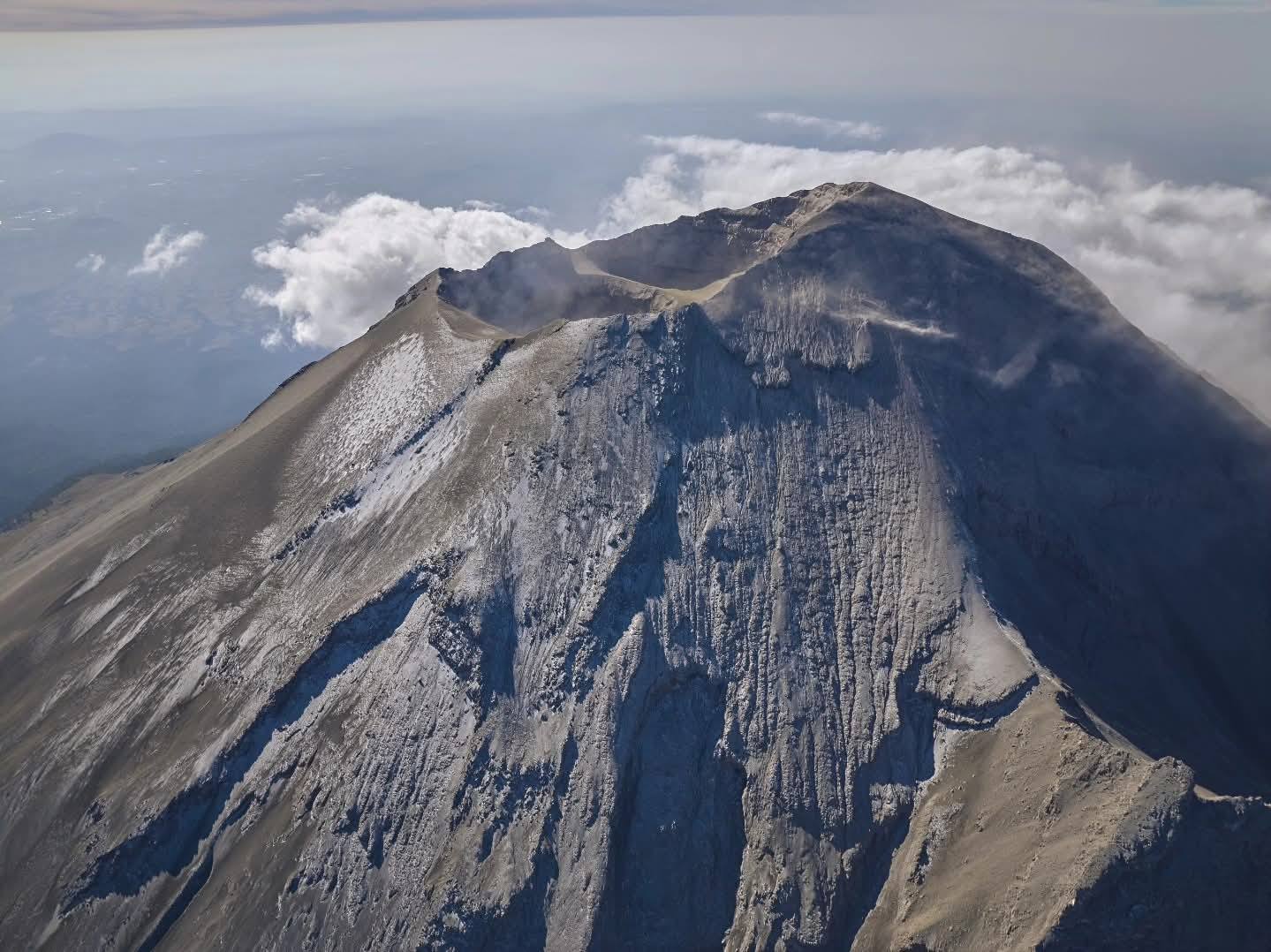
The alert level for Popocatépetl volcano remains at Yellow (Phase 2).
Cenapred strongly advises against attempting to climb the volcano, as explosions ejecting incandescent fragments, as recently observed, are occurring. Respect the 12-kilometer exclusion zone around the crater; being within it is dangerous. In case of heavy rain, stay away from the bottom of ravines due to the risk of mud and debris flows.
Source : Cenapred .
Photo : Ivan Macias