June 1 , 2026.
Hawaii , Kilauea :
HVO/USGS Volcanic Activity Notice
Current Volcano Alert Level: WATCH
Previous Volcano Alert Level: ADVISORY
Current Aviation Color Code: ORANGE
Previous Aviation Color Code: YELLOW
Issued: Saturday, May 30, 2026, 5:49 PM HST
Source: Hawaiian Volcano Observatory
Notice Number: 2026/H247
Location: N 19 deg 25 min W 155 deg 17 min
Elevation: 4091 ft (1247 m)
Area: Hawaii
Summary:
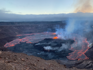
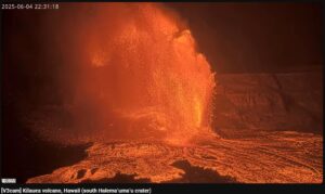
Precursory low-level eruptive activity before episode 48 of the ongoing Halemaʻumaʻu eruption began around 5:41 p.m. HST on May 30. It was preceded by frequent small spatter explosions within the north vent beginning on the evening of May 28.
Volcanic Activity:
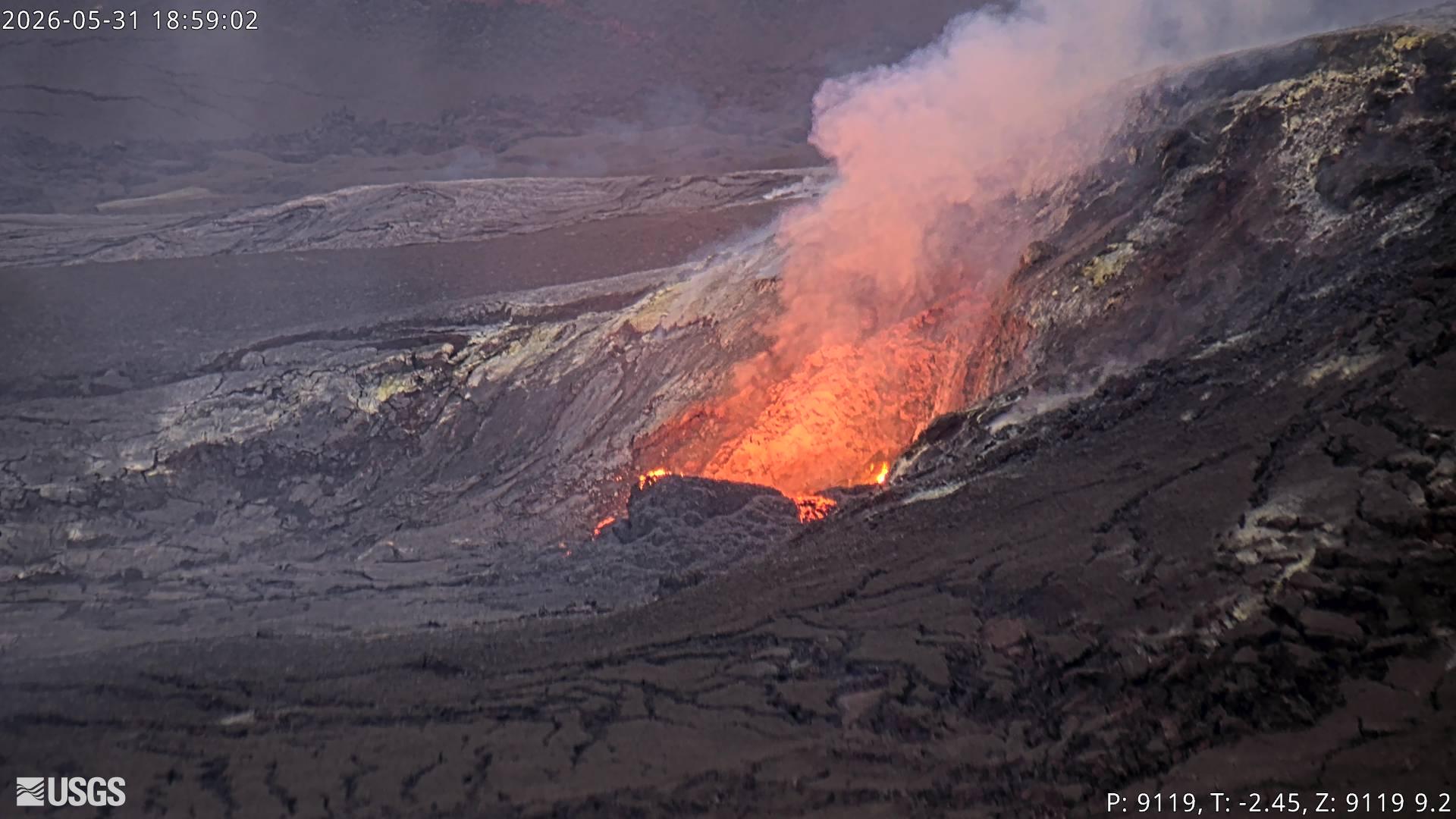
Precursory low-level activity for episode 48 of the ongoing Halemaʻumaʻu eruption at the summit of Kīlauea began around 5:41 p.m. HST on May 30 with lava overflows from the south vent. Accordingly, HVO is raising the Alert Level for Kīlauea from ADVISORY to WATCH and the Aviation Color Code from YELLOW to ORANGE. This low-level precursory activity can continue for hours to days before the lava fountaining episode beings. The forecast for episode 48 of lava fountaining to start is between May 30 and June 1. Another VAN will be published when lava fountaining episode 48 begins.
All eruptive vents and lava flows are confined to Halemaʻumaʻu crater within Hawaiʻi Volcanoes National Park. Tephra fall from volcanic ash clouds is greatest within 3 miles (5 km) of the vents, lighter ash and Pele’s Hair may stay suspended for large distances from the vents.
The USGS Hawaiian Volcano Observatory provided the following update on Sunday morning:
Precursory overflows of degassed lava began from the south vent at 5:41 p.m. HST yesterday May 30. The overflows are generally small and stay within a few hundred meters of the vent. There have been 29 overflows so far that typically last 5-10 minutes and are spaced 15-30 minutes apart. Low dome fountains (5-10 ft or 1-3 m high) feed the passive overflows. The end of events is marked by vigorous drainback of lava and a drop in lava level within the vents. Spattering continued throughout the night building the small cone within the north vent. The vigor of spattering within the north vent greatly increased around 7:51 a.m. HST this morning (May 31) and lava appears to be coming out of the back wall vent and draining into the main vent. No precursory overflows have occurred from the north vent.
Seismic tremor continues but changed to well (d)efined gas pistoning with the first overflow. Low tremor characterizes the overflow followed by a sharp increase associated with drainback of lava. Earthquake activity beneath Kīlauea summit remains low with 6 earthquakes located around Halemaʻumaʻu in the last 24 hours. The largest was a magnitude 1.83 at 6:53 a.m. HST today (May 31) in the center of Halemaʻumaʻu.
Source et photo : HVO
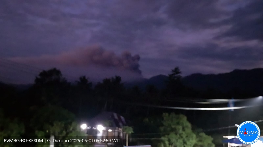
Indonesia , Dukono :
An eruption of Mount Dukono occurred on Monday, June 1, 2026, at 05:40 WIT, with an observed ash column height of approximately 900 m above the summit (approximately 1987 m above sea level). This ash column, white to gray in color, was highly intense and moving eastward. At the time of writing, the eruption was still ongoing.
Seismic Observations
14 eruption earthquakes with amplitudes between 6 and 34 mm and durations of 36.52 to 54.61 seconds.
13 low-frequency earthquakes with amplitudes between 3 and 4 mm and durations of 23.4 to 30.26 seconds.
Continuous tremor with amplitudes between 1 and 3 mm, predominantly 2 mm.
Recommendations
(1) Communities living near Mount Dukono and visitors/tourists are advised to refrain from any activity, climbing, or approaching the Malupang Warirang crater within a 4 km radius.
(2) Since eruptions with volcanic ash projection are periodic and the dispersion of ash depends on the direction and strength of the wind, making the coverage area unstable, communities near Mount Dukono are advised to always have masks/face coverings available to protect themselves from respiratory risks related to volcanic ash.
Source et photo : PVMBG.
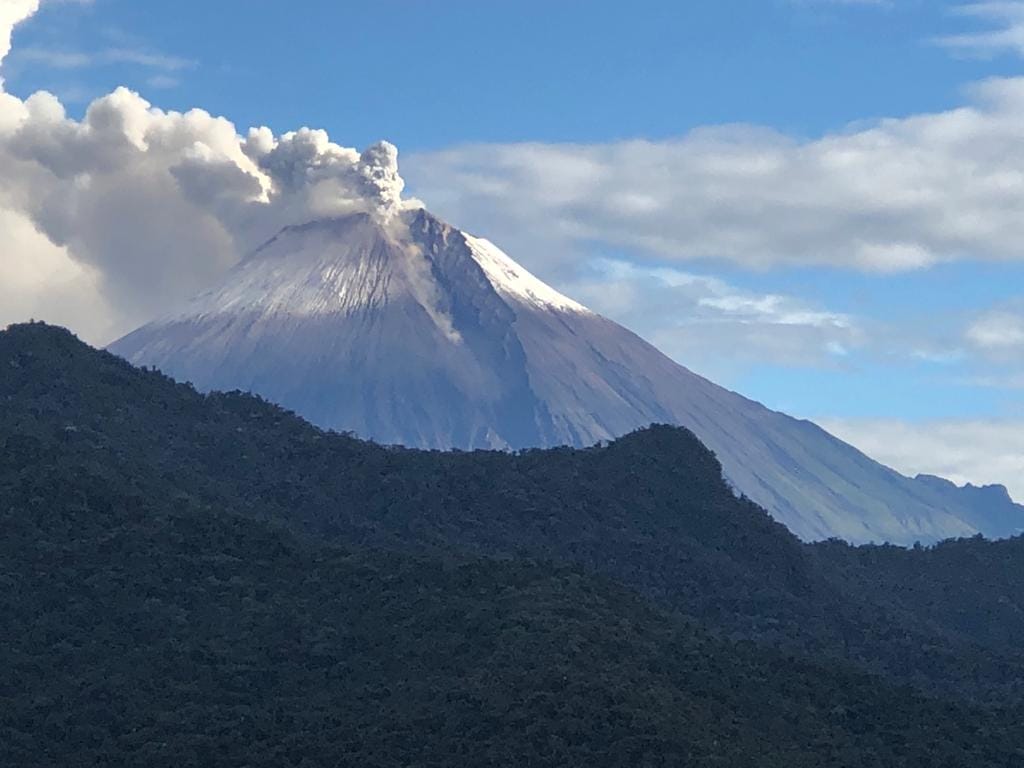
Ecuador , Sangay :
DAILY REPORT ON THE STATE OF SANGAY VOLCANO, Sunday, May 31, 2026.
Geophysical Institute Information – EPN.
Surface Activity Level: High, Surface Trend: No Change
Internal Activity Level: Moderate, Internal Trend: No Change
Seismicity: From May 30, 2026, 11:00 AM to May 31, 2026, 11:00 AM:
Seismicity:
Explosion (EXP): 280
Rain/Lahars:
Precipitation has been recorded in the volcano area, but it has not triggered mudflows or debris flows. Heavy rainfall could remobilize accumulated material, generating mudflows and debris flows that could cascade down the volcano’s flanks and into nearby rivers.
Ash Plume:
Due to weather conditions, no ash emissions were observed via the monitoring camera system or GOES-19 satellite imagery. Furthermore, the Washington VAAC has not reported any ash emissions.
Note:
At the time of writing, the volcano remains shrouded in cloud.
Alert Level: Yellow
Source : IGEPN
Photo : Carlos Riera ( archive).
Costa Rica , Poas :
Daily Volcanic Activity Bulletin. OVSICORI-UNA
Latitude: 10.200
Longitude: -84.233
Altitude: 2,687 m
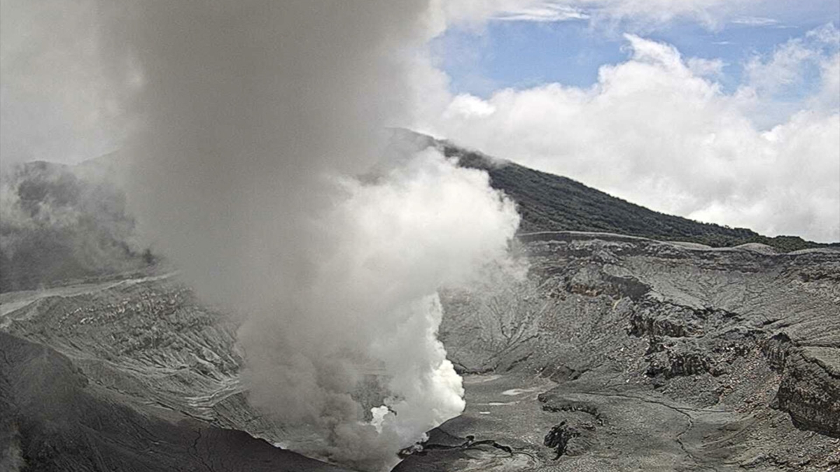
Observed activity:
No eruptions recorded in the last 24 hours.
Continuous seismic tremor is being recorded.
Frequent, long-period (LP), and low-amplitude seismic events are being recorded.
CO₂/SO₂ and H₂S/SO₂ ratios have remained stable in recent weeks.
Yesterday, an increase in SO₂ fluxes was observed compared to the previous week.
Values were estimated between 400 and 600 t/d, with peaks at 1,000 t/d, whereas in previous days, values did not exceed 400 t/d.
Niveau d’activité : Alerte (2)
Source et photo : Ovsicori.
Guatemala , Fuego :
Atmospheric conditions: Clear skies
Wind: Southeast
Rainfall: 30.8 mm
Activity
During the night and early morning, weak to moderate degassing was recorded, with fumaroles reaching approximately 200 meters above the crater and dispersing to the Northwest.
Explosive activity continued with 7 to 12 weak to moderate explosions per hour, generating ash columns between 4,400 and 4,800 meters in altitude, which drifted to the North and Northwest.
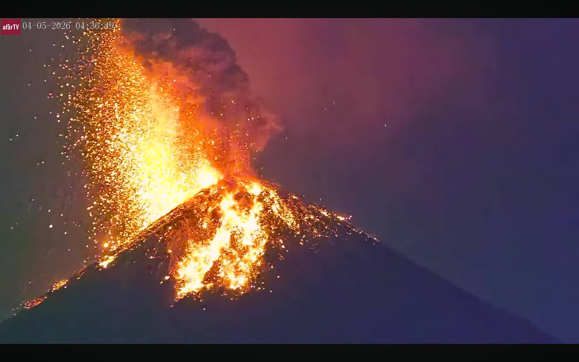
Some explosions were accompanied by rumbling sounds, shock waves, and brief noises similar to those of a locomotive, associated with the continuous expulsion of gas. Incandescent glows were observed up to 200 meters above the crater, accompanied by small avalanches. In addition, incandescent material fell around the crater, flowing into the ravines of Ceniza, Taniluyá, Seca, Santa Teresa, Trinidad, and Las Lajas, sometimes reaching the tree line.
Source : Insivumeh.
Photo : Afar TV.