April 27 , 2026 .
Indonesia , Lewotobi Laki-laki :
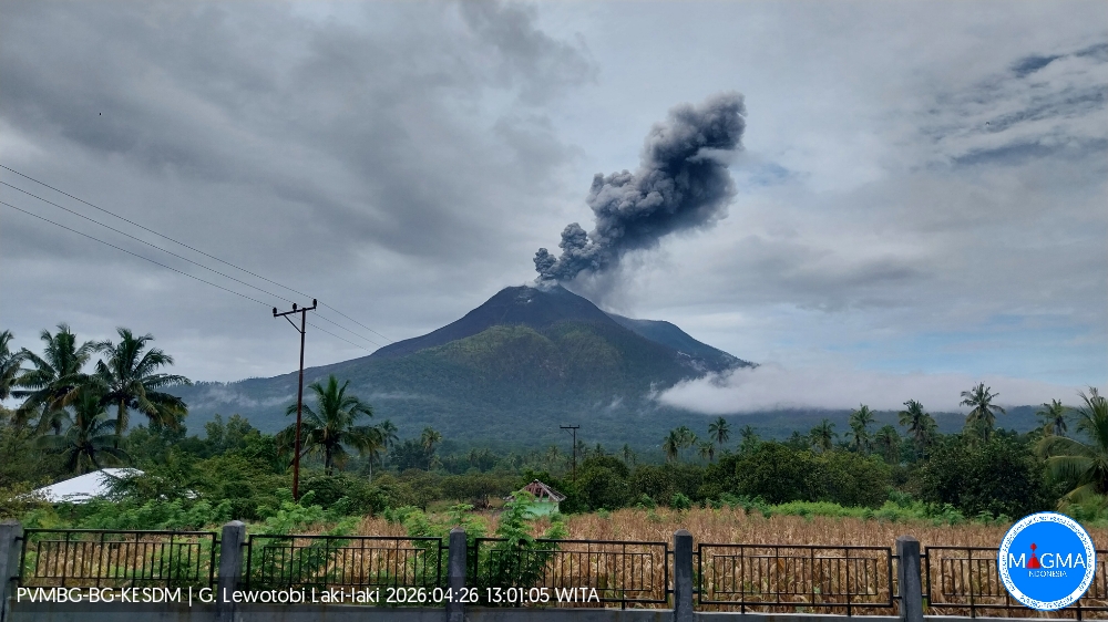
An eruption of Mount Lewotobi Laki-laki occurred on Sunday, April 26, 2026, at 12:57 PM WITA. The observed ash column rose approximately 1,000 meters above the summit (approximately 2,584 meters above sea level). This ash column was gray and very dense, oriented towards the west. The eruption was recorded by a seismograph with a maximum amplitude of 8.8 mm and a duration of 348 seconds.
Seismicity Observations
5 eruption earthquakes with amplitudes between 2.2 and 8.8 mm and durations of 156 to 348 seconds.
7 emission earthquakes with amplitudes between 2.2 and 14.8 mm and durations of 31 to 40 seconds.
8 non-harmonic tremors with amplitudes between 2.2 and 4.4 mm and durations of 71 to 160 seconds.
6 low-frequency earthquakes with amplitudes between 2.9 and 10.5 mm and durations of 19 to 30 seconds.
2 deep volcanic earthquakes with amplitudes between 2.2 and 2.9 mm and durations of 15 to 18 seconds.
Four local tectonic earthquakes with amplitudes ranging from 2.2 to 47.3 mm and durations of 23 to 48 seconds.
Five distant tectonic earthquakes with amplitudes ranging from 2.2 to 4.4 mm and durations of 41 to 105 seconds.
Recommendations
1. Residents living near Mount Lewotobi Laki-laki and visitors/tourists are advised to avoid all activity within a 4 km radius of the eruption’s epicenter.
2. The public is urged to remain calm, follow the instructions of local authorities, and disregard rumors from unknown sources.
Source et photo : PVMBG.
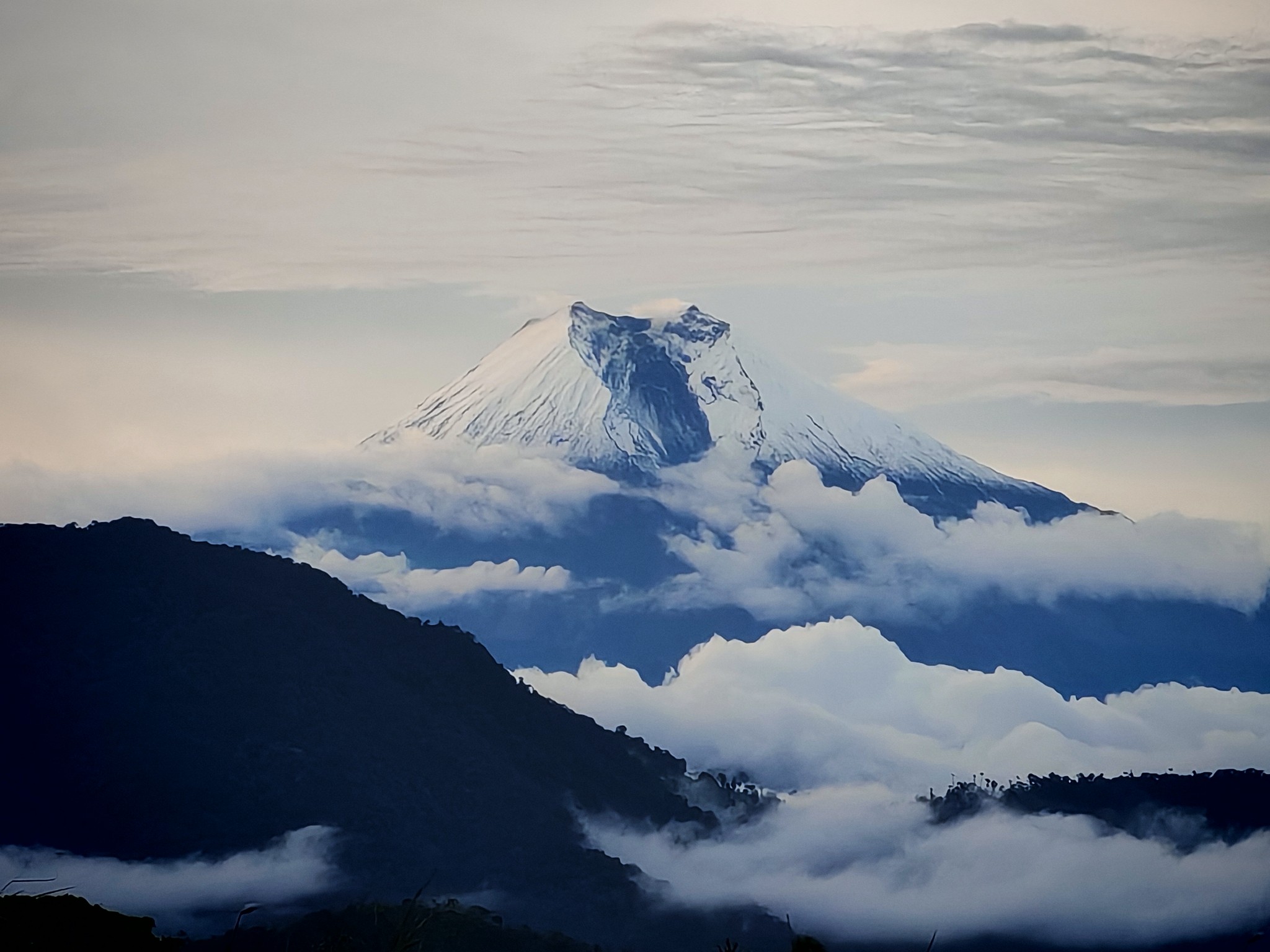
Ecuador , Sangay :
DAILY REPORT ON THE STATE OF SANGAY VOLCANO, Sunday, April 26, 2026.
Geophysical Information Institute – EPN.
Surface Activity Level: High, Surface Trend: No Change
Internal Activity Level: Moderate, Internal Trend: No Change
Seismicity: From April 25, 2026, 11:00 AM to April 26, 2026, 11:00 AM:
Seismicity:
Explosion (EXP): 279
Rainfall/Lahars:
No rainfall has been reported in the area. **Heavy rain could remobilize accumulated material and generate debris-laden mudflows (lahars), which could cascade down the volcano’s flanks and flow into nearby rivers.**
Emissions/Ash:
Due to weather conditions, it was not possible to observe gas and/or ash emissions using the camera network or satellite platforms. However, the Washington VAAC agency issued a report of an ash plume, at an altitude of 1,500 meters above the crater rim, drifting westward.
Gas:
The Mounts satellite system detected 15.4 tons of SO₂ (sulfur dioxide), measured yesterday at 1:13 p.m. local time.
Other monitoring parameters: The FIRMS satellite system detected two thermal anomalies, while the MIROVA-VIIRS satellite system recorded two.
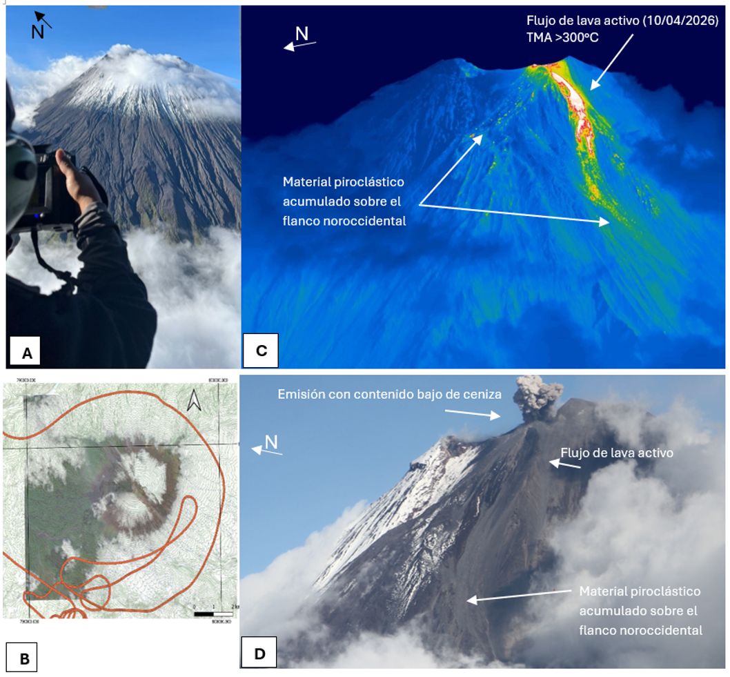
On April 10, 2026, a reconnaissance and monitoring flight of surface activity at Sangay volcano was conducted. Despite cloud cover, visual and infrared monitoring was possible at a distance of 2 to 5 km from the volcano, at a temperature of 14°C and a relative humidity of 45%. Surface activity was characterized by occasional emissions from the North Crater, with a low ash load, generally reaching an altitude of 0.5 to 1 km and dispersed by local winds. In addition, a small active lava flow was observed (from the rim up to an altitude of 4,900 m), as well as localized pyroclastic deposits, particularly on the northwest flank of the volcano, associated with the activity described.
Observation: From yesterday afternoon until the writing of this report, the volcano has remained mostly cloud-covered. In the early morning hours, the camera system observed incandescence at the crater rim and the descent of incandescent material to within 600 meters of the rim.
Alert level: Yellow
Source : IGEPN
Photos : Fabricio Cadena Gómez/ Volcan Sangay / FB , IGEPN.
Colombia , Cerro Machín :
Manizales, April 21, 2026, 8:20 PM
Regarding the monitoring of activity at the Cerro Machín volcano, the Geological Survey of Colombia (SGC), an agency under the Ministry of Mines and Energy, reports the following:
From April 14 to 20, 2026, seismic activity related to rock fracturing within the volcanic edifice continued to be recorded. This activity increased slightly in the number of earthquakes and the seismic energy released compared to the previous week. The earthquakes were located on the southern flank of the volcano and, to a lesser extent, on the main dome and the south-southeast, east-southeast, and south-southwest flanks.
These events were low-energy, with magnitudes less than 1.0, and their depths ranged from 2 to 9 km relative to the volcano’s reference level. Other parameters measured and used to diagnose volcanic activity did not show significant variations during the assessed period.
Therefore, the Geological Survey of Colombia (SGC) recommends closely monitoring developments through weekly bulletins and other information published on its official channels, as well as following the instructions of local and departmental authorities and the National Unit for Disaster Risk Management (UNGRD).
The volcanic activity level remains at yellow alert: active volcano exhibiting changes in the reference behavior of monitored parameters and other manifestations.
Source et photo : SGC.
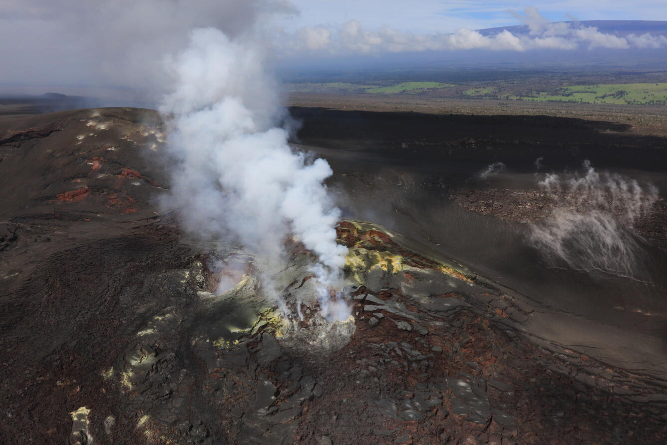
Hawaii , Kilauea :
HAWAIIAN VOLCANO OBSERVATORY DAILY UPDATE , U.S. Geological Survey
Sunday, April 26, 2026, 8:47 AM HST (Sunday, April 26, 2026, 18:47 UTC)
19°25’16 » N 155°17’13 » W,
Summit Elevation 4091 ft (1247 m)
Current Volcano Alert Level: ADVISORY
Current Aviation Color Code: YELLOW
Overview:
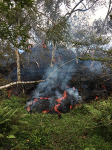
Episode 45 of lava fountaining in Halemaʻumaʻu at the summit of Kīlauea occurred on April 23, 2026. The eruption is currently paused. More information is needed to develop a detailed forecast window for episode 46, but it appears likely that it will occur within the first week of May.
No significant activity has been noted along Kīlauea’s East Rift Zone or Southwest Rift Zone.
Summit Observations:
Consistent glow and occasional flames were visible from the south vent overnight, with only occasional glow from the north vent. Points of incandescence on the crater floor flow field have diminished greatly.
Seismic tremor continues with fewer 1–10 minute bursts that are typical for days after the end of fountaining and is settling into steady low-level tremor. Earthquake activity at the summit has been low; with 15 small earthquakes recorded in the past day, mostly under the pre-2018 location of Halemaʻumaʻu crater.
The Uēkahuna tiltmeter (UWD) recorded about 16.0 microradians of deflationary tilt during episode 45. Since the end of fountaining, summit inflation has resumed, with the same tiltmeter recording about 6.9 microradians of inflationary tilt as of this morning.
With the eruption now paused, the SO2 emission rate is likely varying within a typical range of 1,000 to 5,000 tonnes per day.
Rift Zone Observations:
Rates of seismicity and ground deformation remain low in the East Rift Zone and Southwest Rift Zone. SO2 emissions from the East Rift Zone remain below the detection limit.
Source et photo : HVO.
Guatemala , Fuego :
Atmospheric conditions: Clear skies
Wind: Northeast
Precipitation: 0 mm
Morphology: Composite stratovolcano
Type of activity: Vulcanian
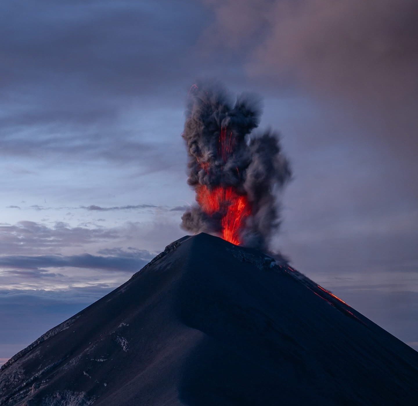
During the night and early morning, weak to moderate explosions were recorded, accompanied by ash columns reaching altitudes of 4,200 to 4,500 meters, which dispersed southwest of the volcanic complex over a distance of approximately 25 kilometers. Avalanches were also observed on the western, southwestern, and southern flanks, with some blocks reaching the vegetation.
Some explosions generated rumbling sounds, shock waves, and noises similar to those of a locomotive.
Due to this activity, it is dangerous to remain on the plateau because of the risk of falling debris.
Source : Insivumeh
Photo : Diego Rizzo .