May 5 , 2026.
Hawaii , Kilauea :
HVO/USGS Volcanic Activity Notice
Current Volcano Alert Level: WATCH
Previous Volcano Alert Level: ADVISORY
Current Aviation Color Code: ORANGE
Previous Aviation Color Code: YELLOW
Issued: Monday, May 4, 2026, 1:50 PM HST
Source: Hawaiian Volcano Observatory
Notice Number: 2026/H204
Location: N 19 deg 25 min W 155 deg 17 min
Elevation: 4091 ft (1247 m)
Area: Hawaii
Volcanic Activity Summary:
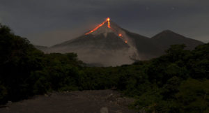
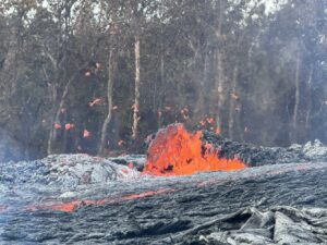
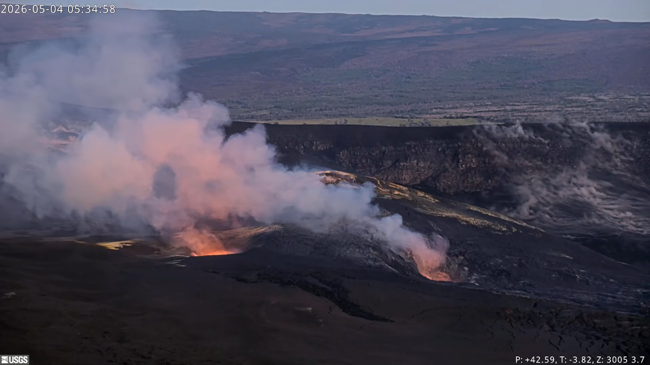
Precursory low-level activity for episode 46 of the ongoing Halemaʻumaʻu eruption at the summit of Kīlauea began around 1:38 a.m. HST on May 4 with lava overflowing from the north vent. Accordingly, HVO is raising the Alert Level for Kīlauea from ADVISORY to WATCH and the Aviation Color Code from YELLOW to ORANGE. This low-level precursory activity can continue for hours to days before the lava fountaining episode beings. The forecast for episode 46 of lava fountaining to start is between May 4-7. Another VAN will be published when lava fountaining episode 46 begins.
All eruptive vents and lava flows are confined to Halemaʻumaʻu crater within Hawaiʻi Volcanoes National Park. Tephra fall from volcanic ash clouds is greatest within 3 miles (5 km) of the vents, lighter ash and Pele’s Hair may stay suspended for large distances from the vents.
Source et photo : HVO.
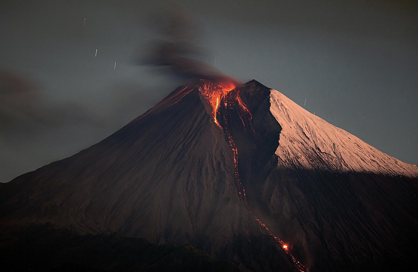
Italy , Stromboli :
Stromboli Activity Update, May 4, 2026, 1:24 PM (11:24 UTC)
The National Institute of Geophysics and Volcanology, Etna Observatory, reports that analysis of CCTV images reveals intense lava ejection activity
in the North Crater area, feeding effusive lava flows of varying intensity. The most advanced front is currently located in the upper-middle part of the Sciara del Fuoco. Strombolian activity continues in the North and South-Central Crater areas.
From a seismic perspective, the average amplitude of volcanic tremors is currently high. No significant changes have been observed in the frequency and amplitude of explosion earthquakes.
The GNSS (HF) network currently shows no significant changes.
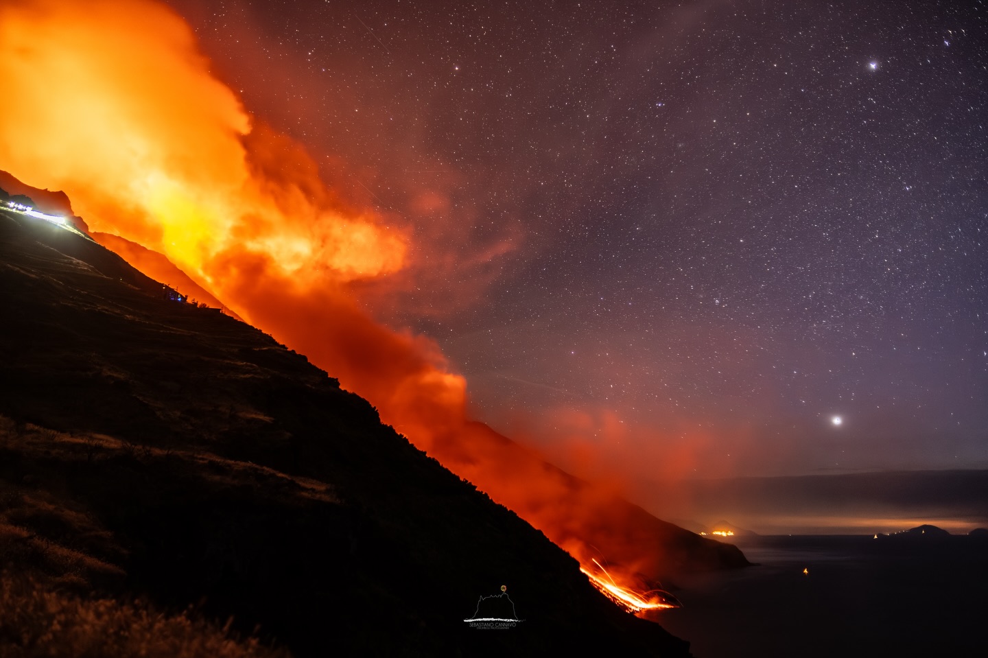
Stromboli Activity Update, May 5, 2026, 06:29 (04:29 UTC)
The National Institute of Geophysics and Volcanology, Etna Observatory, reports that analysis of CCTV footage has revealed an increase in effusive activity due to lava flows from the North Crater area, beginning at 19:20 UTC on May 4. The lava flow progressed along the Sciara del Fuoco, reaching the coastline around 01:00 UTC on May 5. Strombolian activity continues in the North and Central-South Crater areas.
From a seismic perspective, the average amplitude of volcanic tremors is currently within normal limits. A slight increase in the frequency and amplitude of explosion earthquakes has been observed.
The GNSS (HF) network shows no significant changes. Further updates will be communicated promptly and, in any event, within 3 hours of this announcement.
Source : INGV.
Photo : Stromboli stati d’animo / Sebastiano Cannavo
Indonesia , Lewotobi Laki-laki :
INCREASED VOLCANIC ACTIVITY AT LEWOTOBI LAKI-LAKI VOLCANO, EAST NUSA TENGGARA, MAY 4, 2026
During the past week (late April to early May 2026), activity at Mount Lewotobi Laki-laki increased significantly, particularly with regard to deep volcanic earthquakes. Their number began to rise in late April and continued to increase through early May, reaching 21 to 32 per day, compared to 5 to 10 previously. This increase indicates a substantial and sustained influx of magma from deep within the volcano, suggesting a reactivation of the magmatic system.
In addition, other forms of seismic activity, such as non-harmonic tremors, are still being recorded at a relatively high rate, although they are trending downward. In early May, six deep volcanic earthquakes of above-normal magnitude were recorded, their hypocenters estimated to be in the northern part of Mount Lewotobi Laki-laki. The occurrence of these events indicates that pressure from the depths is beginning to be felt in the surface areas, although its development is still limited. Low-frequency (LF) activity remains relatively stable, indicating that the process of fluid transfer from the depths to the surface is continuing.
Deformation data from tiltmeters reveal a significant trend: the Wolorona station (WLR2), located north of the Lewotobi Laki-laki volcano, shows an upward tilt along the Y-axis. This indicates a buildup of pressure in the surface areas, likely a direct response to increased magma upwelling from deeper underground. Meanwhile, another station (NURA), located to the east, shows relatively stable, even weak, deflation conditions. Thus, the overall deformation reflects an uneven pressure rebalancing (localized to the north-northwest) and has not yet resulted in widespread swelling of the volcano.
Compared to the conditions of May-June 2024, the current increase in volcanic activity (VA) resembles the initial phase, characterized by a rise in deep volcanic earthquakes, a sign of magma recharge prior to the onset of eruptive activity. However, in 2024, this increase was accompanied by a strengthening of surface parameters such as low frequencies (LF) and surface volcanic activity (VB), as well as greater deformation, triggering a more intense eruption. Under current conditions, although high VA and signs of local inflation have been observed, no surface response is yet visible. Therefore, current activity is interpreted as being in the early stages of pressure recharge, with the potential for a small to medium-sized eruption if the pressure continues to build and begins to rise more strongly towards the surface.
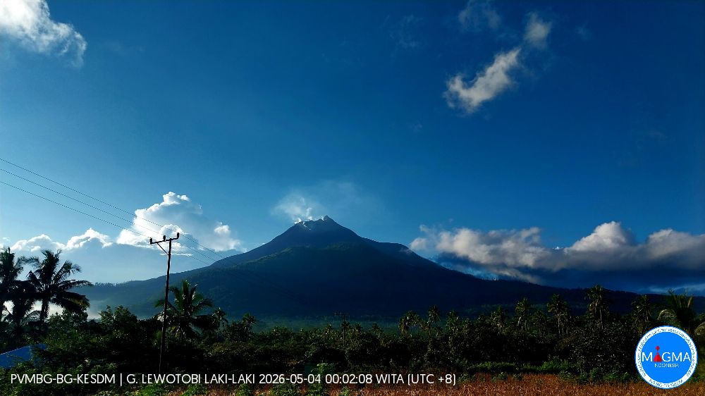
Following these visual and instrumental analyses, the activity level of Mount Lewotobi Laki-laki remains at Level II (WASPADA). The following recommendations are made: the public and tourists are advised to avoid all activity within a 4 km radius of the eruption’s epicenter, to remain calm, and to follow the instructions of local authorities. The public is also asked to disregard information from unknown sources.
Source et photo : PVMBG
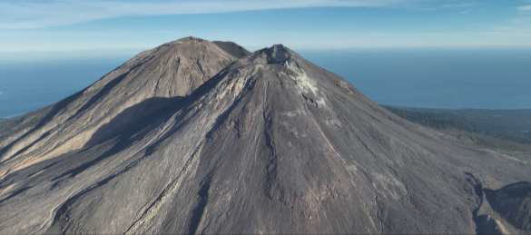
Chile / Argentina , Tupungatito :
The Argentine Geological and Mining Service (SEGEMAR), through its Argentine Volcanological Observatory (OAVV), indicates that the technical alert level for the Tupungatito volcano remains green.
During the evaluated period, volcano-tectonic (VT) seismicity, associated with rock fracturing within the volcano, showed a decrease in the number of recorded events and the energy released compared to the previous period.
The most energetic event, with a local magnitude (ML) of 1.6, occurred 7.4 km north-northeast (NNE) of the volcanic edifice, at a depth of 8 km below the active crater. Long-period (LP) activity, associated with fluid movements within the volcano, increased slightly in both the number of events and energy released compared to the previous period. The most energetic event, measured by its maximum reduced displacement (RD), was 9 cm². Analysis of high-resolution satellite imagery from PlanetScope and Sentinel-2 L2A revealed no surface changes associated with the volcanic edifice.
Source et photo : Cegemar .
Ecuador , Sangay :
DAILY REPORT ON THE STATE OF SANGAY VOLCANO, Monday, May 4, 2026.
Geophysical Institute Information – EPN.
Surface Activity Level: High, Surface Trend: No Change
Internal Activity Level: Moderate, Internal Trend: No Change
Seismicity: From May 3, 2026, 11:00 AM to May 4, 2026, 11:00 AM:
Seismicity:
Explosion (EXP): 165
Rainfall/Lahars:
Rainfall has been recorded in the volcano area, but it has not generated any mudflows or debris flows. **In the event of heavy rainfall, accumulated material could be remobilized, causing mudflows and debris flows that could cascade down the volcano’s flanks and into nearby rivers.**
Emissions/Ash:
Due to poor weather conditions, no ash emissions have been observed by surveillance cameras or the GOES-19 satellite system. The Washington VAAC has also not issued any ash emission reports for this volcano.
Note:
From yesterday afternoon until the time of this report, the volcano has remained completely obscured by clouds.
Alert Level: Yellow
Source : IGEPN
Photo : Eqphos_fotografía