June 9 , 2026.
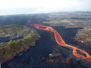
Hawaii , Kilauea :
HAWAIIAN VOLCANO OBSERVATORY DAILY UPDATE , U.S. Geological Survey
Monday, June 8, 2026, 8:36 AM HST (Monday, June 8, 2026, 18:36 UTC)
19°25’16 » N 155°17’13 » W,
Summit Elevation 4091 ft (1247 m)
Current Volcano Alert Level: ADVISORY
Current Aviation Color Code: YELLOW
Summary:
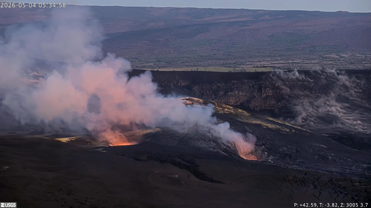
Kīlauea volcano is not erupting; the summit eruption in Halemaʻumaʻu is paused. Episode 48 occurred on June 1. Forecast models based on summit inflation rates indicate that episode 49 of lava fountaining is likely to occur between June 12 and 15.
Overview:
The summit eruption of Kīlauea in Halemaʻumaʻu remains paused following 9 hours of lava fountaining during episode 48 on June 1, 2026. Tiltmeters around the summit of Kīlauea have measured inflation since the end of episode 48, indicating that an episode 49 of lava fountaining is likely; forecast models indicate that the onset of fountaining episode 49 could occur between June 12-15. Glow was visible at the vents overnight and robust degassing plumes are visibly emanating from both vents in Halemaʻumaʻu during the day.
No significant activity has been noted along Kīlauea’s East Rift Zone or Southwest Rift Zone.
Summit Observations:
Bright and continuous glow was visible from the south vent in Halemaʻumaʻu overnight along with periodic flaming, likely caused by the ignition of volcanic gases escaping the vent. Intermittent glow visible from the north vent. Robust degassing plumes are visibly emanating from both vents in Halemaʻumaʻu during the day.
No earthquakes were detected beneath Kaluapele (Kīlauea caldera) within the past 24 hours.
The UWD tiltmeter located near Uēkahuna at Kīlauea summit recorded a total of 17.1 microradians of deflationary tilt during episode 48. Once the episode ended, inflation resumed and UWD has since recovered 11 microradians of inflationary tilt.
With the eruption now paused, the sulfur dioxide (SO2) emission rate from the summit is likely now varying within a typical range of 1,000 to 5,000 tonnes per day.
Rift Zone Observations:
Rates of seismicity and ground deformation remain low in the East Rift Zone and Southwest Rift Zone. SO2 emissions from the East Rift Zone remain below the detection limit.
Source et photo : HVO
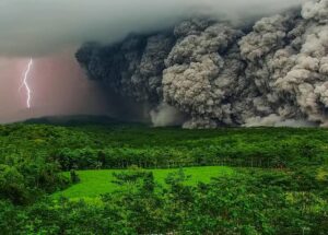
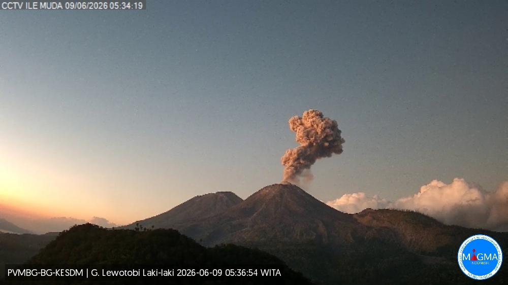
Indonesia , Lewotobi Laki-laki :
An eruption of Mount Lewotobi Laki-laki occurred on Tuesday, June 9, 2026, at 5:31 AM WITA. The observed ash column rose approximately 1,000 meters above the summit (approximately 2,584 meters above sea level). This gray ash column was highly intense and directed southwest and west. The eruption was recorded by a seismograph, with a maximum amplitude of 44.4 mm and a duration of 93 seconds.
Seismic Observations:
Five eruption earthquakes with amplitudes ranging from 24.4 to 47.3 mm and durations from 91 to 128 seconds.
Two non-harmonic tremors with amplitudes ranging from 7.4 to 22.2 mm and durations from 91 to 128 seconds.
VOLCANO OBSERVATORY NOTICE FOR AVIATION – VONA
Issued : June 9 , 2026
Volcano : Lewotobi Laki-laki (264180)
Current Aviation Colour Code : ORANGE
Previous Aviation Colour Code : orange
Source : Lewotobi Laki-laki Volcano Observatory
Notice Number : 2026LWK073
Volcano Location : S 08 deg 32 min 20 sec E 122 deg 46 min 06 sec
Area : East Nusa Tenggara, Indonesia
Summit Elevation : 5069 FT (1584 M)
Volcanic Activity Summary :
Eruption with volcanic ash cloud at 21h31 UTC (05h31 local).
Volcanic Cloud Height :
Best estimate of ash-cloud top is around 8269 FT (2584 M) above sea level or 3200 FT (1000 M) above summit. May be higher than what can be observed clearly. Source of height data: ground observer.
Other Volcanic Cloud Information :
Ash cloud moving from southwest to west. Volcanic ash is observed to be gray. The intensity of volcanic ash is observed to be thick.
Remarks :
Eruption recorded on seismogram with maximum amplitude 44.4 mm and maximum duration 93 second.
Source et photo : PVMBG.
Costa Rica , Rincon de la Vieja :
Latitude: 10.83°N;
Longitude: 85.34°W;
Altitude: 1916 m above sea level.
Current activity level: Alert.
No eruptions or exhalations were recorded this week. Background tremor showed an increase in amplitude and frequency starting on June 3 (1 and 7 Hz). The number of long-period events decreased this week. However, an increase in high-frequency events was observed. Fourteen volcano-tectonic earthquakes distal to the crater and three proximal to it were recorded.
The geodetic network shows no significant deformation. The MultiGAS station continues to record low SO₂ concentrations. This week, the NOVAC stations recorded 112 ± 25 tonnes of SO₂ per day, a slightly lower rate than the previous week (144 ± 96 t/d). The last detection of SO₂ in the atmosphere by the SENTINEL satellite, emitted by the Rincón de la Vieja volcano, dates back to September 7, 2025.
Source et photo : Ovsicori.
Ecuador , El Reventador :
REVENTADOR VOLCANO DAILY STATE REPORT, Monday, June 8, 2026.
Geophysical Information Institute – EPN.
Surface Activity Level: High, Surface Trend: No Change
Internal Activity Level: Moderate, Internal Trend: No Change
From June 7, 2026, 11:00 AM to June 8, 2026, 11:00 AM:
Seismicity:
Explosion (EXP) 77
Long Period (LP) 31
Emission Tremor (TREMI) 8
Harmonic Tremor (TRARM) 4
Rainfall/Lahars:
No rainfall likely to generate mud and debris flows has been recorded in the volcano area.
In the event of heavy rainfall, accumulated material could be remobilized, causing mud and debris flows that would cascade down the volcano’s flanks and flow into nearby rivers.
Emissions/Ash:
Over the past 24 hours, surveillance cameras have recorded two gas and ash plumes reaching altitudes of 800 and 1,000 meters above the crater, drifting west and northwest. Regarding this activity, the Washington VAAC issued three reports of gas and ash plumes reaching altitudes of 1,100 meters above sea level, drifting northwest, west, and west-northwest.
Other monitoring parameters:
The FIRMS and MIROVA satellite systems recorded no thermal anomalies in the last 24 hours.
Observation:
Overnight and early this morning, monitoring cameras recorded several episodes of incandescent material falling from the volcano’s flanks, up to 1,000 meters below the crater rim. At the time of writing, the volcano remains shrouded in mist.
Alert level – SGR: Orange
Source et photo : IGEPN.
Guatemala , Santiaguito :
Atmospheric conditions: Cloudy
Wind: East
Rainfall: 53.8 mm
Activity:
The Santiaguito Volcanological Observatory reports unfavorable conditions for observing the dome due to cloud cover. Weak to moderate explosions are reported at a rate of 1 to 2 per hour, projecting columns of gas and ash up to 700 meters in altitude. These columns are drifting west and northwest under the influence of the wind. Incandescence is visible on the dome, as well as the detachment of incandescent rock blocks toward the west, southwest, and south flanks.
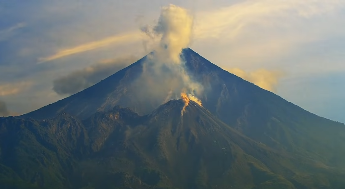
Ashfall is possible on Monte María, Loma Linda, and the surrounding areas due to the wind direction. Because of the significant accumulation of rock material, the Caliente dome and the promontory overlooking the lava flow are at risk of collapsing and generating long-range pyroclastic flows to the southwest. Therefore, the recommendations of Special Bulletin BESAN-016-2026 should be followed.
Source : Insivumeh .
Photo : Afar tv