June 15 , 2026.
Hawaii , Kilauea :
HAWAIIAN VOLCANO OBSERVATORY STATUS REPORT , U.S. Geological Survey , Sunday, June 14, 2026, 6:15 PM HST (Monday, June 15, 2026, 04:15 UTC)
19°25’16 » N 155°17’13 » W,
Summit Elevation 4091 ft (1247 m)
Current Volcano Alert Level: ADVISORY
Current Aviation Color Code: YELLOW
Summary:
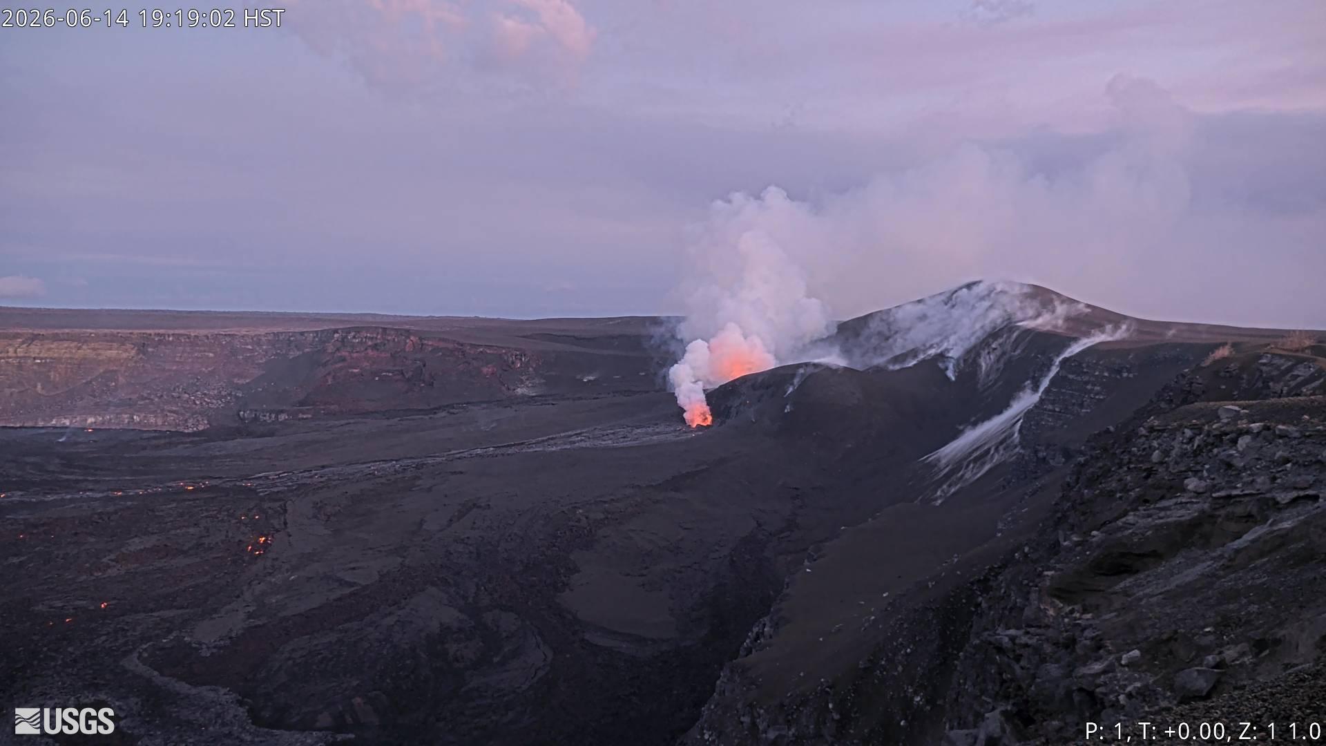
Episode 49 of the ongoing Halemaʻumaʻu eruption at the summit of Kīlauea ended abruptly at 5:05 p.m. HST on June 14. The eruption is currently paused.
Activity Summary:
Episode 49 of the ongoing Halemaʻumaʻu eruption at the summit of Kīlauea ended abruptly at 5:05 p.m. HST on June 14, 2026, after 7.5 hours of continuous lava fountaining from the north vent. The eruption is currently paused.
Tephra fall was restricted to the closed are of Hawaiʻi Volcanoes National Park to the southwest of the active Halemaʻumaʻu vents. No significant tephra or ash fall was reported from open overlooks in Hawaiʻi Volcanoes National Park or in the surrounding communities at this time.
Episode 49 Chronology:
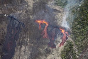
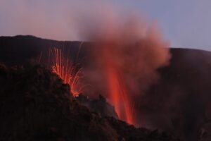
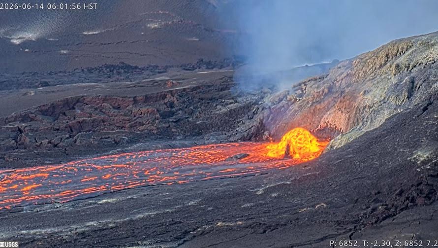
Lava fountaining episode 49 in Halemaʻumaʻu at the summit of Kīlauea began at 9:36 a.m. HST on June 14 and stopped abruptly at 5:05 p.m. HST, after just under 7.5 hours of continuous fountaining from the north vent. The last 2-3 minutes was marked by gas jetting from the north vent. The south vent never fountained during this episode, but it periodically spattered or jetted, sending spatter no more than 150 feet (50 meters) into the air. The instantaneous effusion rate peaked at about 415 cubic yards (320 cubic meters) per second between 10:30 and 11:00 a.m. HST, with an average effusion rate of 260 cubic yards (200 cubic meters) per second for the entire fountaining episode. An estimated 6.5 million cubic yards (5 million cubic meters) of lava erupted and covered about 40-50% of the Halemaʻumaʻu crater floor. The Uēkahuna tiltmeter (UWD) recorded about 15.5 microradians of deflationary tilt during episode 49. Seismicity followed the normal change in tremor patterns seen after most fountain episodes. There were no locatable earthquakes associated with the end of the eruption.
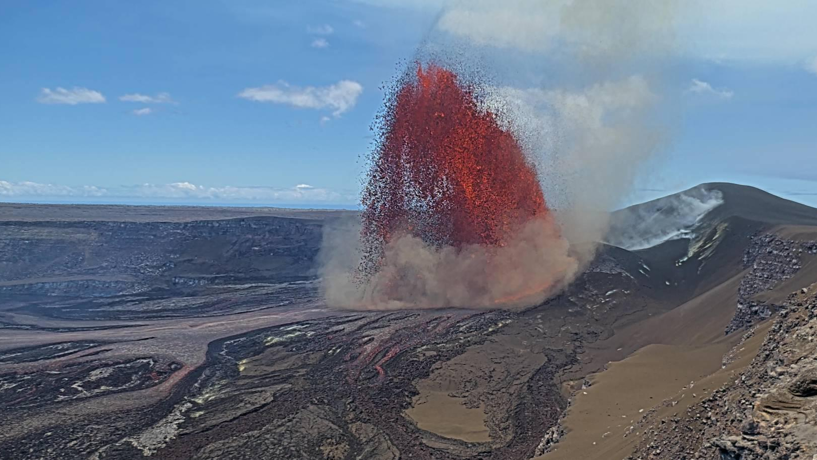
Episode 49 lava fountaining began a little over 5 hours after the onset of precursory lava overflows at 4:10 a.m. HST from the north vent on the morning of June 14. The initial overflow lasted about 20 minutes and was followed by another north vent overflow from 5:59 to 7:04 a.m. HST. North vent dome fountaining restarted at 8:14 a.m. HST then steadily escalated in vigor and height until it transitioned to episode 49 fountaining at 9:36 a.m. HST. The south vent first overflowed at 6:34 a.m. HST while the north vent was overflowing. Intermittent overflows continued from south vent until 9:12 a.m. HST. There were eight south vent overflows in total, each lasting no longer than 7 minutes. Tremor dropped during the south vent overflows and all ended with drain back events that produced noticeable tremor bursts, a pattern typical of gas pistoning. Meanwhile, the north vent lava fountain grew steadily until reaching a maximum height of about 700 feet (210 meters) by around 10:30 a.m. HST. Over the next several hours the fountain height gradually declined, and it was estimated about 300 feet (90 meters) high about 1 hour before the episode ended at 5:05 p.m. HST on June 14.
The north vent lava fountain produced significant heat and ash, feeding a plume that reached a maximum height of about 18,000 feet (5,500 meters) above sea level based on radar data and verified by webcam images. Winds were out of the northeast for most of the eruption causing the plume to move to the southwest during the most energetic part of the eruption. The plume track largely remained within Hawaiʻi Volcanoes National Park with most tephra fall in the closed area. The more distal part of the plume track roughly followed the Southwest Rift Zone and USGS field crews did not find tephra in the Pahala community.
At 2:55 p.m. HST, the National Weather Service updated their Special Weather Statement to include the areas adjacent to the summit of Kīlauea as having potential for ash fall due to a switch to light and variable winds in the area. USGS HVO field crews drove Crater Rim Drive, Highway 11, and into surrounding communities (Volcano, Mauna Loa Estates, and Ohia Estates) without finding any significant ash fall around 3:30 p.m. HST. No ash fall was reported within Hawaiʻi Volcanoes National Park, except for very sparse Peleʻs hairs found on parked cars near KMC.
Source et photo : HVO.
Indonesia , Dukono :
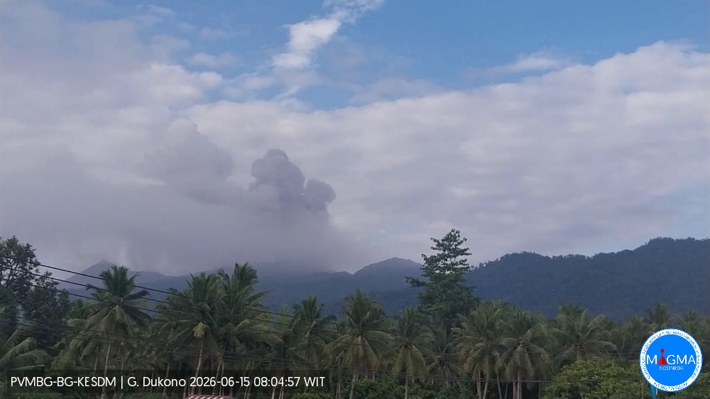
An eruption of Mount Dukono occurred on Monday, June 15, 2026, at 07:57 WIT, with an observed ash column height of approximately 1300 m above the summit (approximately 2387 m above sea level). This ash column, white to gray in color, was highly intense and directed eastward. The eruption was recorded by a seismograph with a maximum amplitude of 34 mm and a duration of 47.97 seconds.
Seismicity Observations
190 eruption earthquakes with amplitudes between 7 and 34 mm and durations from 40.93 to 99.2 seconds.
68 low-frequency earthquakes with amplitudes between 4 and 6 mm and durations from 28.7 to 40.63 seconds.
3 distant tectonic earthquakes with amplitudes between 6 and 20 mm and durations from 71.52 to 109.61 seconds.
1 continuous tremor earthquake with amplitudes between 1 and 6 mm, primarily 2 mm.
Recommendations
(1) Residents living near Mount Dukono and visitors/tourists are advised to refrain from any activity, climbing, or approaching the Malupang Warirang crater within a 4 km radius.
(2) Considering that eruptions with volcanic ash occur periodically and that the distribution of ash follows the direction and speed of the wind, so that the area where the ash lands is not constant, people living around Mount Dukono are advised to always carry masks/face coverings and mouth coverings to use when needed to avoid the threat that volcanic ash poses to the respiratory system.
Source et photo : PVMBG.
Colombia , Cumbal :
San Juan de Pasto, June 9, 2026, 4:50 PM
Regarding the monitoring of activity at the Combal Volcanic Complex (CVC), the Colombian Geological Survey (SGC), an agency under the Ministry of Mines and Energy, reports the following:
During the week of June 2-8, 2026, the main variations in monitored parameters compared to the previous week were as follows:
● An increase in the frequency of earthquakes and their energy release was recorded. The most significant contribution to this activity is seismicity associated with rock fracturing.
● Most of the seismic activity occurred near the summit of the volcanic complex, at shallow depths, and with a magnitude less than 1.4.
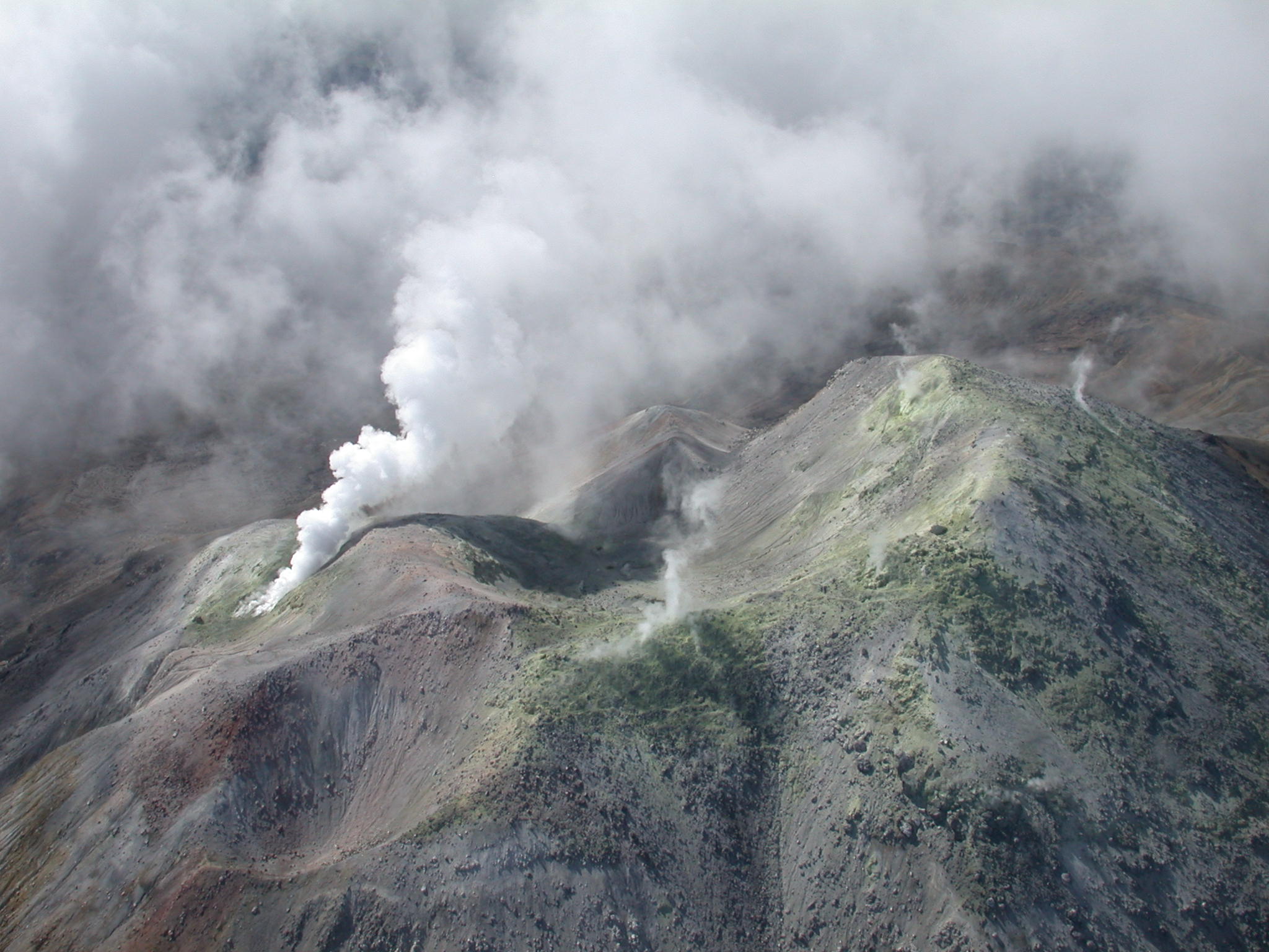
● Gas emissions were recorded at the El Verde fumaroles, located northeast of the CVC, and at Rastrojos, located southwest of the volcano. The plume’s dispersion direction was variable due to wind.
● Other volcanic monitoring parameters remained stable.
Given the above, the Colombian Geological Survey (SGC) recommends closely monitoring developments by consulting weekly bulletins and other information published through its official channels, as well as following the instructions of local and departmental authorities and the National Unit for Disaster Risk Management (UNGRD).
Volcanic activity remains at the yellow alert level: active volcano exhibiting changes in the baseline behavior of monitored parameters and other manifestations.
Source et photo : SGC.
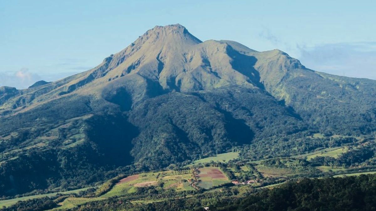
La Martinique , Mount Pelée :
Weekly Report, Paris Institute of Earth Physics / Martinique Volcanological and Seismological Observatory.
Saint-Pierre, June 12, 2026, 3:30 PM local time (GMT-4)
Between June 5, 2026, 4:00 PM UTC and June 12, 2026, 4:00 PM UTC, the Martinique Volcanological and Seismological Observatory (OVSM) recorded 108 volcanic earthquakes:
• 108 volcano-tectonic earthquakes. Among them, 10 had a magnitude (local magnitude Mlv or duration magnitude Md) greater than 0.5 and 5 had a magnitude greater than 1. The largest had a magnitude Mlv of 1.72. The others were of lower energy. The vast majority of these earthquakes were located at depths between 0.8 and 1.4 km below the volcano’s summit.
However, one earthquake was initially located at a depth of approximately 8 km below sea level, north of Mount Pelée. This volcano-tectonic seismicity is associated with microfracturing within the volcanic edifice, linked to the overall reactivation of the volcano observed since 2019. No earthquakes were felt by the local population.
The previous week, the OVSM (Swiss Volcanic Observatory) recorded 138 volcanic earthquakes. As of June 12, 2026, and over the past four weeks, the OVSM has observed a total of 358 volcanic earthquakes, an average of 89 to 90 earthquakes per week.
During periods of volcanic reactivation of volcanoes similar to Mount Pelée, seismic activity of varying intensity and frequency is common. The probability of an eruptive activity in the short term remains low. However, based on observations accumulated in recent years, and particularly in recent months, a change in the situation in the medium term (weeks to months) cannot be ruled out.
The volcanic alert level, in accordance with the measures implemented by the authorities, is currently YELLOW: vigilance.
Source et photo : Direction de l’OVSM-IPGP.
Guatemala , Santiaguito :
Atmospheric conditions: Clear
Wind: East
Rainfall: 0.0 mm
Activity:
White degassing is observed above the Caliente dome, with fumaroles rising up to 700 meters and dispersing to the west and southwest. One to three low- to medium-intensity explosions occur per hour, projecting columns of gas and ash up to 800 meters above the dome in the same direction. During the night and early morning, incandescence was recorded in the crater, accompanied by collapses and the fall of incandescent blocks on its flanks.
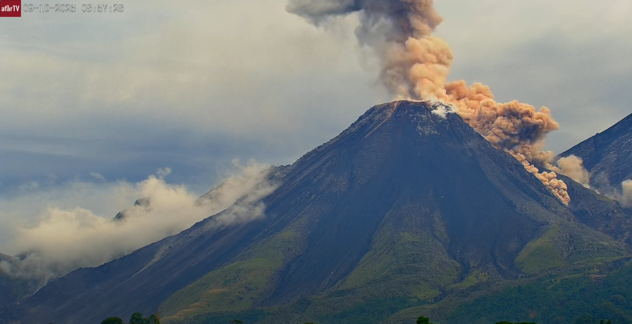
Given the high level of activity and the risk of major collapses, the generation of long-range pyroclastic density currents in all directions cannot be ruled out. Therefore, it is recommended to follow the instructions in Special Bulletin BESAN-002-2026. Furthermore, rainfall may mobilize accumulated material in ravines and riverbeds, causing lahars in the afternoon and evening. It is recommended to avoid ravines and riverbeds and to strictly follow the instructions in Special Bulletin BESAN-012-2026.
Source : Insivumeh.
Photo : Afar tv.