June 14 , 2026.
Indonesia , Lewotobi Laki-laki :
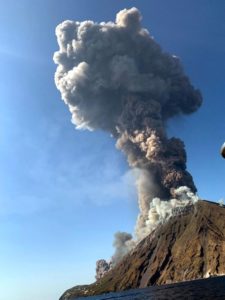
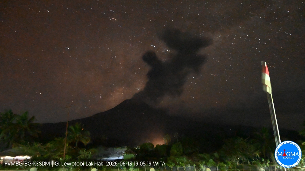
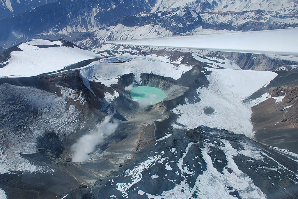
An eruption of Mount Lewotobi Laki-laki occurred on Saturday, June 13, 2026, at 6:55 PM WITA. The observed ash column rose approximately 1,000 meters above the summit (approximately 2,584 meters above sea level). This ash column was gray and very dense, and was oriented towards the west and northwest. The eruption was recorded by a seismograph, with a maximum amplitude of 44.4 mm and a duration of 57 seconds.
Seismic Observations:
Four eruption earthquakes with amplitudes ranging from 44.4 to 47.3 mm and durations of 50 to 96 seconds.
Two non-harmonic tremors with amplitudes ranging from 5.9 mm and durations of 68 to 93 seconds.
Three low-frequency earthquakes with amplitudes between 2.9 and 11 mm and durations of 23 to 29 seconds.
Three distant tectonic earthquakes with amplitudes between 2.2 and 2.9 mm and durations of 70 seconds, as well as earthquakes with durations between 118 and 127 seconds.
VOLCANO OBSERVATORY NOTICE FOR AVIATION – VONA
Issued : June 13 , 2026
Volcano : Lewotobi Laki-laki (264180)
Current Aviation Colour Code : ORANGE
Previous Aviation Colour Code : orange
Source : Lewotobi Laki-laki Volcano Observatory
Notice Number : 2026LWK093
Volcano Location : S 08 deg 32 min 20 sec E 122 deg 46 min 06 sec
Area : East Nusa Tenggara, Indonesia
Summit Elevation : 5069 FT (1584 M)
Volcanic Activity Summary :
Eruption with volcanic ash cloud at 10h55 UTC (18h55 local).
Volcanic Cloud Height :
Best estimate of ash-cloud top is around 8269 FT (2584 M) above sea level or 3200 FT (1000 M) above summit. May be higher than what can be observed clearly. Source of height data: ground observer.
Other Volcanic Cloud Information :
Ash cloud moving from west to northwest. Volcanic ash is observed to be gray. The intensity of volcanic ash is observed to be thick.
Remarks :
Eruption recorded on seismogram with maximum amplitude 44.4 mm and maximum duration 57 second.
Source et photo : PVMBG.
Colombia , Nevado del Ruiz :
Manizales, June 9, 2026, 8:10 PM
Regarding the monitoring of activity at the Nevado del Ruiz volcano, the Colombian Geological Survey (SGC), an agency under the Ministry of Mines and Energy, reports the following:
During the week of June 2-8, 2026, the volcano continued to exhibit unstable behavior. Compared to the previous week, the main variations in monitored parameters were as follows:
– Seismicity associated with fluid dynamics within the volcanic conduits increased, both in the number of events and in the seismic energy released, particularly for short-duration signals. Despite this increase, the signals displayed low energy levels. Conversely, no long-duration seismic signals were recorded this week, and no pulsatile ash emissions or variations in the apparent temperature of the gas column were observed.
Seismic activity associated with rock fracturing processes within the volcanic edifice decreased, both in the number of recorded events and in the seismic energy released. The events occurred primarily in the Arenas crater and, to a lesser extent, in various sectors of the volcano, particularly on the north-northeast and northeast flanks, up to 10 km from the crater. The depth of the earthquakes varied between less than 1 km and 2 km in the Arenas crater, and between 2 km and 7 km in the other sectors. The maximum recorded magnitude was 1.1, corresponding to the earthquake that occurred on June 8 at 3:58 a.m., 10 km northwest of the Arenas crater and at a depth of 6 km.
The emission of water vapor and volcanic gases, primarily sulfur dioxide (SO₂), into the atmosphere continued through the Arenas crater. The estimated SO₂ flux, associated with degassing processes, remained variable and low, and decreased compared to the previous week. This decrease is due to a return to levels observed before the increase recorded on May 31. Additional monitoring, using satellite data, also showed low levels of SO₂ emissions.
– The height of the gas and water vapor column remained mostly below 400 m. On the morning of June 7, it reached a maximum of 600 m, measured above the summit of the volcano. The ash plume’s dispersion direction was variable, with a preferential tendency toward the northwest flank and, to a lesser extent, toward the north-northeast and north-northwest flanks of the volcano.
Monitoring of thermal anomalies at the bottom of the Arenas crater using satellite platforms was limited by persistent cloud cover in the region. Therefore, no thermal anomalies were detected this week.
Source et photo : SGC.
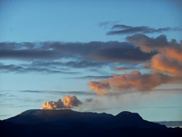
Chile , Tupungatito :
The Argentine Geological and Mining Service (SEGEMAR), through its Argentine Volcanological Observatory (OAVV), indicates that the technical alert level for the Tupungatito volcano remains Green.
PERIOD ANALYSIS
During the evaluated period, volcano-tectonic (VT) seismicity, associated with rock fracturing within the volcano, showed values similar to those of the previous period, both in terms of the number of recorded events and the energy released. The most energetic event, with a local magnitude (ML) of 1.6, occurred 8.3 km north-northeast (NNE) of the volcanic edifice, at a depth of 8.6 km below the active crater.
Long-period (LP) activity, associated with fluid movements within the volcano, showed a decrease in energy released and the number of events compared to the previous period. The most energetic event, measured by its maximum reduced displacement (RD), was 15 cm². A single hybrid seismic (HB) event was observed, associated with both rock fracturing and fluid dynamics within the volcanic system. Its energy, measured by its reduced displacement (DR), was 1 cm². During the analyzed period, satellite image processing revealed the persistence of very low-power thermal anomalies recorded by VIIRS375. Analysis of high-resolution satellite images from PlanetScope and Sentinel-2 L2A detected no surface changes related to the volcanic edifice.
CONCLUSIONS
For the evaluated period, volcanic activity remains within the reference limits for this volcano, suggesting stability of the volcanic system. Therefore, the technical alert level remains in place and monitoring of the volcano continues in constant communication with the Southern Andes Volcanological Observatory (OVDAS) in Chile. Any changes will be reported.
Source et photo : Segemar.
Costa Rica , Rincon de la Vieja :
Latitude: 10.83°N;
Longitude: 85.34°W;
Altitude: 1916 m
Current Activity Level: Alert.
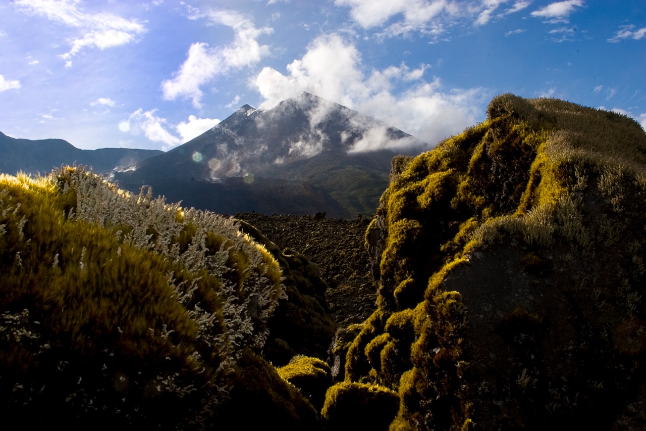
No eruptions or exhalations were recorded this week. The last eruption occurred on May 20. Background tremor remains generally stable, with a frequency between 1 and 7 Hz; however, its amplitude varies. The number of long-period events decreased this week. Conversely, there was an increase in high-frequency events. Six distal and seven proximal volcano-tectonic earthquakes were recorded. The geodetic network is recording contractions and subsidence at the summit; however, no clear pattern is detected at the base of the volcano.

The MultiGAS station continues to record low SO₂ concentrations. This week, NOVAC stations recorded 103 ± 68 tonnes of SO₂ per day, a rate similar to that of the previous week (112 ± 25 t/d). The last detection of SO₂ in the atmosphere by the SENTINEL satellite, emitted by the Rincón de la Vieja volcano, dates back to September 7, 2025.
Source : Ovsicori
Photo : Federico Chavarría-Kopper – Ovsicori
Ecuador , El Reventador :
REVENTADOR VOLCANO DAILY STATE REPORT, Saturday, June 13, 2026.
Information Geophysical Institute – EPN.
Surface Activity Level: High, Surface Trend: No Change
Internal Activity Level: Moderate, Internal Trend: No Change
From June 12, 2026, 11:00 AM to June 13, 2026, 11:00 AM:
Seismicity:
Explosion (EXP) 87
Long Period (LP) 8
Emission Tremor (TREMI) 10
Harmonic Tremor (TRARM) 8
Rainfall/Lahars:
Rainfall has been recorded in the region, but it has not triggered any lahars. **Heavy rainfall can remobilize accumulated material and generate debris-laden mudflows (lahars), which could rush down the volcano’s flanks and flow into nearby rivers.**
Emissions/Ash:
Several gas and ash emissions have been observed using monitoring cameras and satellite imagery. These emissions reached altitudes between 500 and 1,000 meters above the crater and moved southwest. Regarding this activity, the VAAC agency in Washington issued two emission reports, with altitudes between 700 and 1,000 meters above sea level, and directions of southwest and west-northwest.
Gas:
The MOUNTS satellite system recorded 2.6 tonnes of sulfur dioxide (SO₂), measured yesterday at 1:14 p.m. local time.
Other monitoring parameters:
The MIROVA-MODIS satellite system recorded a thermal anomaly.
Observation:
During the night and early morning, incandescent material fell from the volcano’s flanks, reaching up to 1,000 meters below the crater. At the time of writing, the volcano remains completely obscured by clouds.
Alert level – SGR: Orange
Source et photo : IGEPN.