June 11 , 2026 .
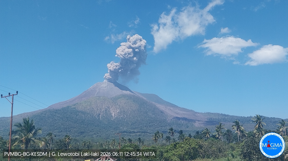
Indonesia , Lewotobi Laki-laki :
An eruption of Mount Lewotobi Laki-laki occurred on Thursday, June 11, 2026, at 12:43 PM WITA. The observed ash column rose approximately 1,000 meters above the summit (approximately 2,584 meters above sea level). This ash column was gray and very dense, oriented towards the west and northwest. The eruption was recorded by a seismograph, with a maximum amplitude of 44.4 mm and a duration of 67 seconds.
Seismic Observations:
Three eruption earthquakes with amplitudes between 44.4 and 47.3 mm and durations of 37 to 50 seconds.
Five non-harmonic tremors with amplitudes between 7.4 and 11 mm and durations of 80 to 102 seconds.
A low-frequency earthquake with an amplitude of 3.7 mm and a duration of 22 seconds.
Two tectonic earthquakes, separated by amplitudes between 3.7 and 7.4 mm and durations of 50 to 71 seconds and 136 to 152 seconds respectively.
VOLCANO OBSERVATORY NOTICE FOR AVIATION – VONA
Issued : June 11 , 2026
Volcano : Lewotobi Laki-laki (264180)
Current Aviation Colour Code : ORANGE
Previous Aviation Colour Code : orange
Source : Lewotobi Laki-laki Volcano Observatory
Notice Number : 2026LWK081
Volcano Location : S 08 deg 32 min 20 sec E 122 deg 46 min 06 sec
Area : East Nusa Tenggara, Indonesia
Summit Elevation : 5069 FT (1584 M)
Volcanic Activity Summary :
Eruption with volcanic ash cloud at 04h43 UTC (12h43 local).
Volcanic Cloud Height :
Best estimate of ash-cloud top is around 8269 FT (2584 M) above sea level or 3200 FT (1000 M) above summit. May be higher than what can be observed clearly. Source of height data: ground observer.
Other Volcanic Cloud Information :
Ash cloud moving from west to northwest. Volcanic ash is observed to be gray. The intensity of volcanic ash is observed to be thick.
Remarks :
Eruption recorded on seismogram with maximum amplitude 44.4 mm and maximum duration 67 second.
Source et photo : PVMBG.
Colombia , Chiles / Cerro Negro :
San Juan de Pasto, June 9, 2026, 4:50 PM
Regarding the monitoring of activity at the Chiles-Cerro Negro Volcanic Complex (CVCCN), the Colombian Geological Survey (SGC), an agency under the Ministry of Mines and Energy, reports the following:
For the period from June 2 to 8, 2026, the main variations in monitored parameters, compared to the previous week, were as follows:
● In a context of fluctuating seismic activity, a decrease in the number of events and the energy released was recorded. Seismicity associated with rock fracturing remained predominant, followed by seismicity related to fluid dynamics.
● Most of the earthquakes occurred south of Chiles Volcano, with a few to the east. Depths generally ranged from 1 to 8 km below the summit of Chiles Volcano (4,700 m above sea level). The highest magnitude earthquake, 2.9, occurred on June 5 at 11:56 a.m., with its epicenter located east of Chiles Volcano. This earthquake was felt by residents in the surrounding area.
● Analysis of data from satellite sensors and ground stations continued to reveal variations related to deformation processes in the volcanic zone.
Based on the assessment and correlation of monitored parameters, the Geological Survey of Colombia (SGC) recommends closely monitoring the evolving situation through weekly bulletins and other information published on its official channels, as well as following the instructions of local and departmental authorities and the National Disaster Risk Management Unit (UNGRD).
Volcanic activity remains at the yellow alert level: Active volcano with changes in the baseline behavior of monitored parameters and other manifestations.
Source et photo : SGC.
Chile , Laguna del Maule :
SPECIAL REPORT ON VOLCANIC ACTIVITY, June 9, 2026
The Argentine Geological and Mining Service (SEGEMAR), through its Argentine Volcanic Monitoring Observatory (OAVV), reports that today, Tuesday, June 9, 2026, at 7:25 a.m. local time (10:25 UTC), volcanic monitoring stations located near the Laguna del Maule volcanic complex recorded a volcano-tectonic (VT) earthquake associated with rock fracturing within the volcanic system.
Event Information
Origin Time: 7:25 a.m. local time (10:25 UTC)
Latitude: -36.112°
Longitude: -70.501°
Depth: 5.0 km
Local Magnitude: 3.0 (ML)
OBSERVATIONS:
No surface activity or variation in other monitoring parameters was detected at the volcanic complex. This event had no impact on Argentine territory, and no reports were received from neighboring populations in Argentina.
CONCLUSIONS:
The technical alert level remains in effect, and monitoring of the volcano continues in constant communication with the Southern Andes Volcanological Observatory (OVDAS) of Chile. Any changes will be communicated.
Source : Segemar.
Photo : OVDAS.
Hawaii , Kilauea :
HAWAIIAN VOLCANO OBSERVATORY DAILY UPDATE , U.S. Geological Survey
Wednesday, June 10, 2026, 9:07 AM HST (Wednesday, June 10, 2026, 19:07 UTC)
19°25’16 » N 155°17’13 » W,
Summit Elevation 4091 ft (1247 m)
Current Volcano Alert Level: ADVISORY
Current Aviation Color Code: YELLOW
Summary:
Kīlauea volcano is not erupting; the summit eruption in Halemaʻumaʻu is paused following episode 48 on June 1. Forecast models indicate that episode 49 of lava fountaining is likely to occur between June 12-15.
Overview:
The summit eruption of Kīlauea in Halemaʻumaʻu remains paused following the end of episode 48 on June 1, 2026. Tiltmeters around the summit of Kīlauea have measured inflation since the end of episode 48, indicating that episode 49 of lava fountaining is likely; forecast models indicate that the onset of fountaining episode 49 is likely to occur between June 12-15. Glow was visible at the vents overnight and robust degassing plumes are visibly emanating from both vents in Halemaʻumaʻu during the day.
No significant activity has been noted along Kīlauea’s East Rift Zone or Southwest Rift Zone.
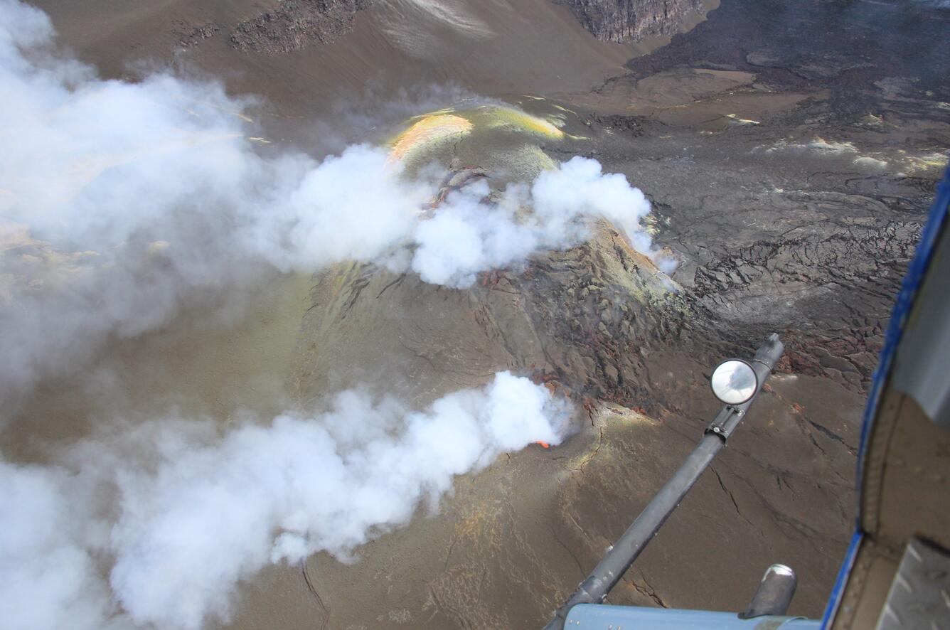
USGS scientists conduct Kīlauea summit monitoring overflight on June 9, 2026, to document changes to the eruptive vents and crater floor after episode 48 that took place on June 1. Both the north (top) and south (bottom) vents continue to emit volcanic gases during the pauses between fountaining episodes, and visible glow from south vent during the overflight on June 9 shows that magma is at shallow depths within the vent.
Summit Observations:
Strong glow and occasional spatter was visible from the south vent in Halemaʻumaʻu overnight along with periodic flaming, likely caused by the ignition of volcanic gases escaping the vent. Continuous glow was visible from the north vent. Lava was visible in the south vent during a helicopter overflight yesterday. Robust degassing plumes are visibly emanating from both vents in Halemaʻumaʻu during the day.
Low level tremor related to the active vents continues to be recorded across summit seismometers.
The UWD tiltmeter located near Uēkahuna at Kīlauea summit recorded a total of 17.1 microradians of deflationary tilt during episode 48. Once the episode ended, inflation resumed and UWD has since recovered 13.5 microradians of inflationary tilt.
During inter-episode pauses, sulfur dioxide (SO2) emission rates from the summit typically vary between 1,000 to 5,000 tonnes per day.
Rift Zone Observations:
Rates of seismicity and ground deformation remain low in the East Rift Zone and Southwest Rift Zone. SO2 emissions from the East Rift Zone remain below the detection limit.
Source : HVO
Photo : USGS / B. Corsa.
Guatemala , Fuego :
Atmospheric conditions: Partly clear
Wind: Northeast
Rainfall: 33.0 mm
Activity
The Fuego volcano continues its activity with moderate to strong explosions, generating ash plumes between 4,200 and 4,700 meters in altitude. This ash is being transported southwest for a distance of approximately 30 km. It is accompanied by avalanches of incandescent blocks and loose volcanic material on the west, south, and southwest flanks of the volcano. Ashfall has been reported in Panimache I and II, Morelia, Santa Sofía, El Porvenir, and other locations in the region.
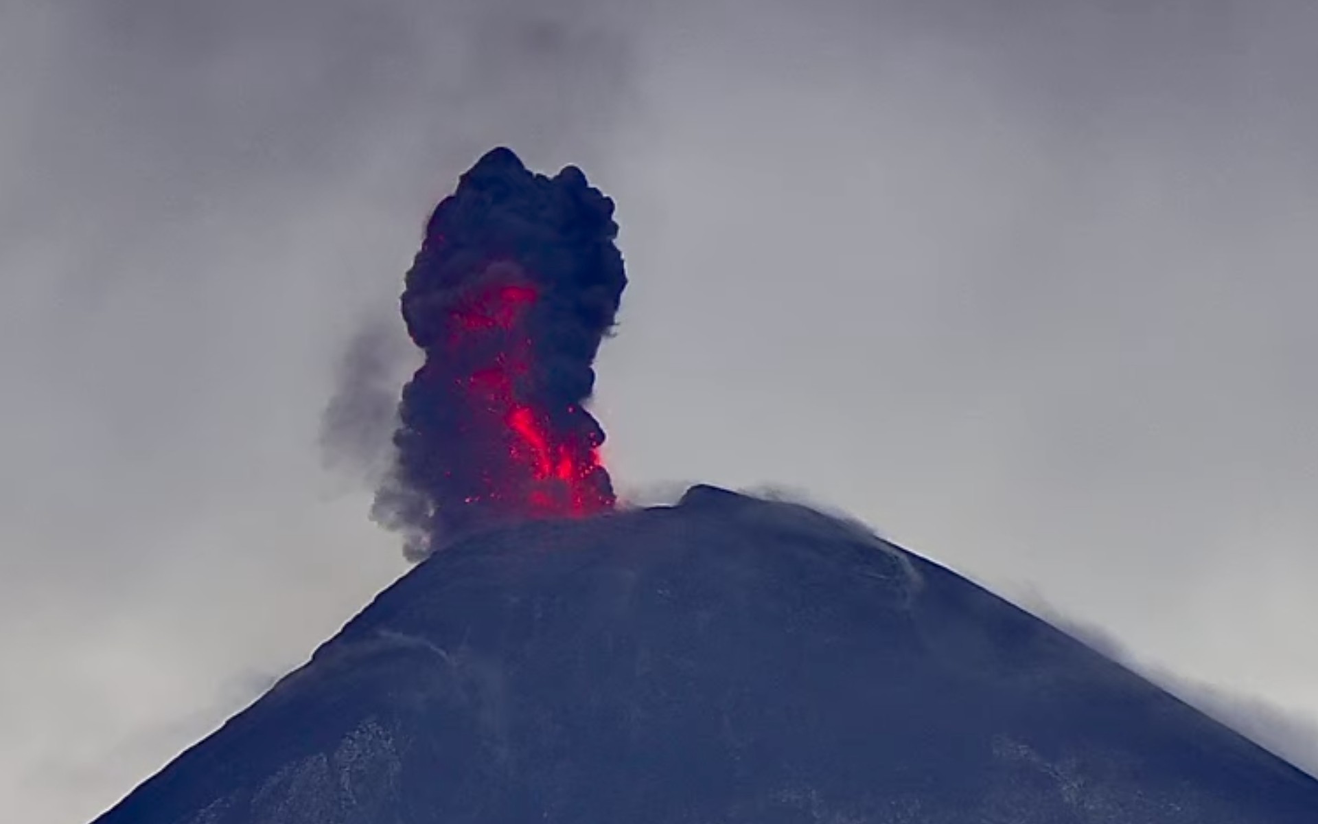
Some explosions generated moderate to loud rumbling sounds, accompanied by shockwaves felt in the surrounding towns and villages. Noises similar to those of a locomotive were also reported. The explosive activity is projecting ballistic material more than 500 meters around the crater, making it extremely dangerous to remain on the plateau and near the active crater due to the risk of impact with incandescent fragments and volcanic blocks. Given the weather conditions, it is recommended to wear clothing suitable for cold and rain. Extra caution is also advised when crossing streams, especially in the afternoon and evening.
Source : Insivumeh
Photo : Afar TV.