July 17 , 2026.
Hawaii , Kilauea :
HAWAIIAN VOLCANO OBSERVATORY DAILY UPDATE , U.S. Geological Survey
Thursday, July 16, 2026, 9:55 AM HST (Thursday, July 16, 2026, 19:55 UTC)
19°25’16 » N 155°17’13 » W,
Summit Elevation 4091 ft (1247 m)
Current Volcano Alert Level: ADVISORY
Current Aviation Color Code: YELLOW
Summary:
Kīlauea volcano is not erupting; the summit eruption in Halemaʻumaʻu is paused. Episode 51 ended at 4:46 p.m. HST on July 15. Re-inflation indicates another episode is likely but more data are needed to determine the forecast.
Overview:
The summit eruption of Kīlauea in Halemaʻumaʻu is paused following 8.3 hours of lava fountaining during episode 51 on July15, 2026. Inflation measured by tiltmeters around the summit of Kīlauea resumed after episode 51 ended accompanied by continued glow from both vents, suggesting that another episode is likely. More data are needed to determine the forecast.
No significant activity has been noted along Kīlauea’s East Rift Zone or Southwest Rift Zone.
NOTE:
The V1 camera is on a temporary assignment to watch an area that has displayed persistent subsidence after several fountain episodes. It will return to its « normal » job of keeping an eye on the north vent when the current assignment is completed.
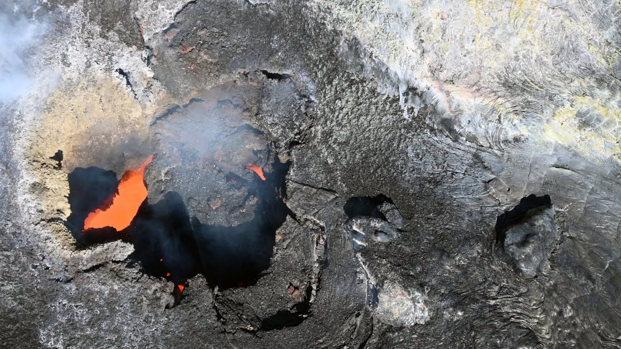
This aerial view, looking down into the north vent in Halema‘uma‘u, was taken during a USGS Hawaiian Volcano Observatory monitoring overflight on the morning of July 14, 2026. Small amounts of spatter over the last 12 hours have deposited on and around the vent, giving it a more textured look in the interior part of the depression. A small spatter cone had been building over the vent, but it collapsed prior to the overflight.
Summit Observations:
Bright glow and flames were visible overnight from both the north and south vents in Halema’uma’u. Numerous bright, shifting incandescent spots were visible overnight from lava flows that erupted onto the floor of Halema’uma’u crater and the slopes of the active vents during episode 51. Strong glow was visible from cracks and around the edges of these flows and from overturns and breakouts that exposed still-molten lava. Slow movements from cooling lava flows and gravity induced slumps on the vents are expected to continue in the coming days and nights. Degassing plumes from both vents are being blown toward the southwest this morning.
Low-frequency seismic pulsing began with the cessation of episode 51 and continues this morning, which is typical during the onset of pauses between eruptive episodes. There were two shallow earthquakes within Kaluapele (Kīlauea caldera) in the past 24 hours, the largest of which was a M2.0 beneath the southeast corner of Halemaʻumaʻu.
Kīlauea summit deflation totaled 14.7 microradians during episode 51. Once the episode ended, inflation resumed and has since recovered 2.2 microradians of tilt at the summit tiltmeter at Uēkahuna (UWD).
The sulfur dioxide (SO2) emission rate from the summit is likely now varying within a typical range of 1,000 to 5,000 tonnes per day.
Rift Zone Observations:
Rates of seismicity and ground deformation remain low in the East Rift Zone and Southwest Rift Zone. SO2 emissions from the East Rift Zone remain below the detection limit.
Source : HVO.
Photo : USGS / L. Gallant.
Alaska , Complexe volcanique d’Atka :
AVO/USGS Volcanic Activity Notice
Current Volcano Alert Level: ADVISORY
Previous Volcano Alert Level: NORMAL
Current Aviation Color Code: YELLOW
Previous Aviation Color Code: GREEN
Issued: Thursday, July 16, 2026, 5:03 AM AKDT
Source: Alaska Volcano Observatory
Notice Number: 2026/A521
Location: N 52 deg 19 min W 174 deg 8 min
Elevation: 5030 ft (1533 m)
Area: Aleutians
Summary:
Small phreatic (steam) explosion detected, Color Code and Alert Level raised to YELLOW/ADVISORY.
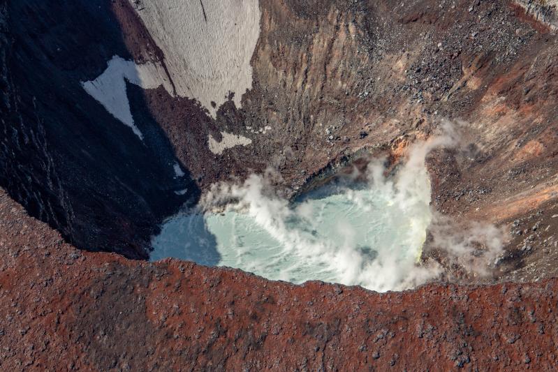
Steaming crater lake inside of the summit crater of Korovin Volcano in the Atka Volcanic Complex during an Alaska Volcano Observatory observation and gas measurement flight on August 28, 2025. The lake is warm with sulfur deposits floating on top due to an active hydrothermal system.
Volcanic Activity:
A small explosion from Korovin Volcano was detected in seismic and infrasound data at 3:55 am AKDT (11:55 UTC) this morning, July 16, 2026. The Aviation Color Code and Alert Level are being raised to YELLOW/ADVISORY. No emissions were observed in satellite images, but regional clouds would obscure activity below 10,000 feet (3 km) asl. Possible ash clouds generated by such events are expected to be small and dissipate quickly. Fallout of ash, if any, is unlikely to extend much beyond the upper flanks of the volcano.
Remarks:
The Atka volcanic complex forms the northern part of Atka Island, located about 16 km north of the community of Atka and 1,761 km southwest of Anchorage. The Atka volcanic complex includes a possible older caldera and several younger vents, including Korovin Volcano, Mount Kliuchef, and Sarichef Volcano. Korovin Volcano, a 1553-m-high (5030 ft) stratovolcano, has been the site of most historical volcanic activity, and has a small, roiling crater lake that occasionally produces energetic steam emissions. Korovin has erupted several times in the past 200 years, including 1973, 1987, and 1998, and has likely had small ash emissions as recently as 2005. Typical recent Korovin eruptions produce minor amounts of ash and occasional but small lava flows. Reports of the height of the ash plume produced by the 1998 eruption ranged as high as 10,600 m (35,000 feet) above sea level. Mount Kliuchef is composed of a series of five vents aligned northeast–southwest. The two main summit vents of Kliuchef appear relatively young and the easternmost was probably the source of an 1812 eruption that is sometimes attributed to Sarichef.
Source : AVO.
Photo : Dietterich, Hannah / AVO/USGS.
Japan , Kuchinoerabujima :
The Japan Meteorological Agency (JMA) reported that the number of shallow volcanic earthquakes beneath an area near Kuchinoerabujima’s Furudake Crater had been fluctuating since May. The number of shallow volcanic earthquakes began increasing at around 01h00 on 9 July and by 02h15 the seismic network had recorded a total of 11 events. There were no changes to emissions with white plumes rising as high as 200 m above the Shindake crater rim and no emissions visible at Furudake. Sulfur dioxide emissions remained low, averaging less than 100 tons per day on 8 July. The Alert Level was raised to 2 (on a scale of 1-5) at 02h25; the public was warned that ejected blocks may land within 1 km of both craters, and pyroclastic flows may affect areas within 2 km of the W flank of Shindake Crater. Seismicity declined with no volcanic earthquakes recorded from 04h00 on 9 July to 16h00 on 10 July.
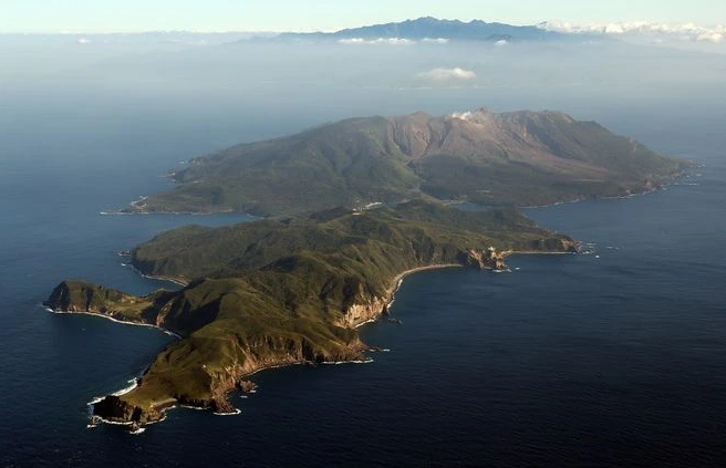
A group of young stratovolcanoes forms the eastern end of the irregularly shaped island of Kuchinoerabujima in the northern Ryukyu Islands, 15 km W of Yakushima. The Furudake, Shindake, and Noikeyama cones were erupted from south to north, respectively, forming a composite cone with multiple craters. All historical eruptions have occurred from Shindake, although a lava flow from the S flank of Furudake that reached the coast has a very fresh morphology. Frequent explosive eruptions have taken place from Shindake since 1840; the largest of these was in December 1933. Several villages on the 4 x 12 km island are located within a few kilometers of the active crater and have suffered damage from eruptions.
Sources: Japan Meteorological Agency (JMA) , GVP.
Photo : Asahi Shimbun.
Philippines , Kanlaon :
The Philippine Institute of Volcanology and Seismology (PHIVOLCS) reported that a moderately explosive eruption at Kanlaon began at 07h33 on 9 July and lasted for three minutes based on seismic and acoustic data. Webcams views of the eruption were obscured by weather clouds, but a dense grayish ash plume was estimated to have risen 2-3 km above the summit based on photos taken from greater distances. Pyroclastic density currents (PDCs) descended the upper SE flanks at least 1 km, but were also not clearly visible. Reports on social media indicated that angular rock fragments up to 30 cm in diameter were ejected within 5 km, impacting parts of Canlaon City (10 km ESE), Negros Oriental. The ejected ballistics represented the farthest reach of ballistic fragments since the 3 June 2024 eruption. A shockwave produced a booming or rumbling sound, heard up to 35 km away, that registered as a maximum of 255 pascals by an infrasound station about 5 km E. The eruption was preceded by relatively moderate levels of seismic activity, intermittent ash emission at the summit crater, and sustained rates of volcanic gas emissions. Sulfur dioxide emissions rates on 8 July averaged 2,454 tonnes per day (t/d), near the long-term average of 2,577 t/d recorded since 3 June 2024, but higher than the average of 1,544 t/d recorded since 1 January 2026.
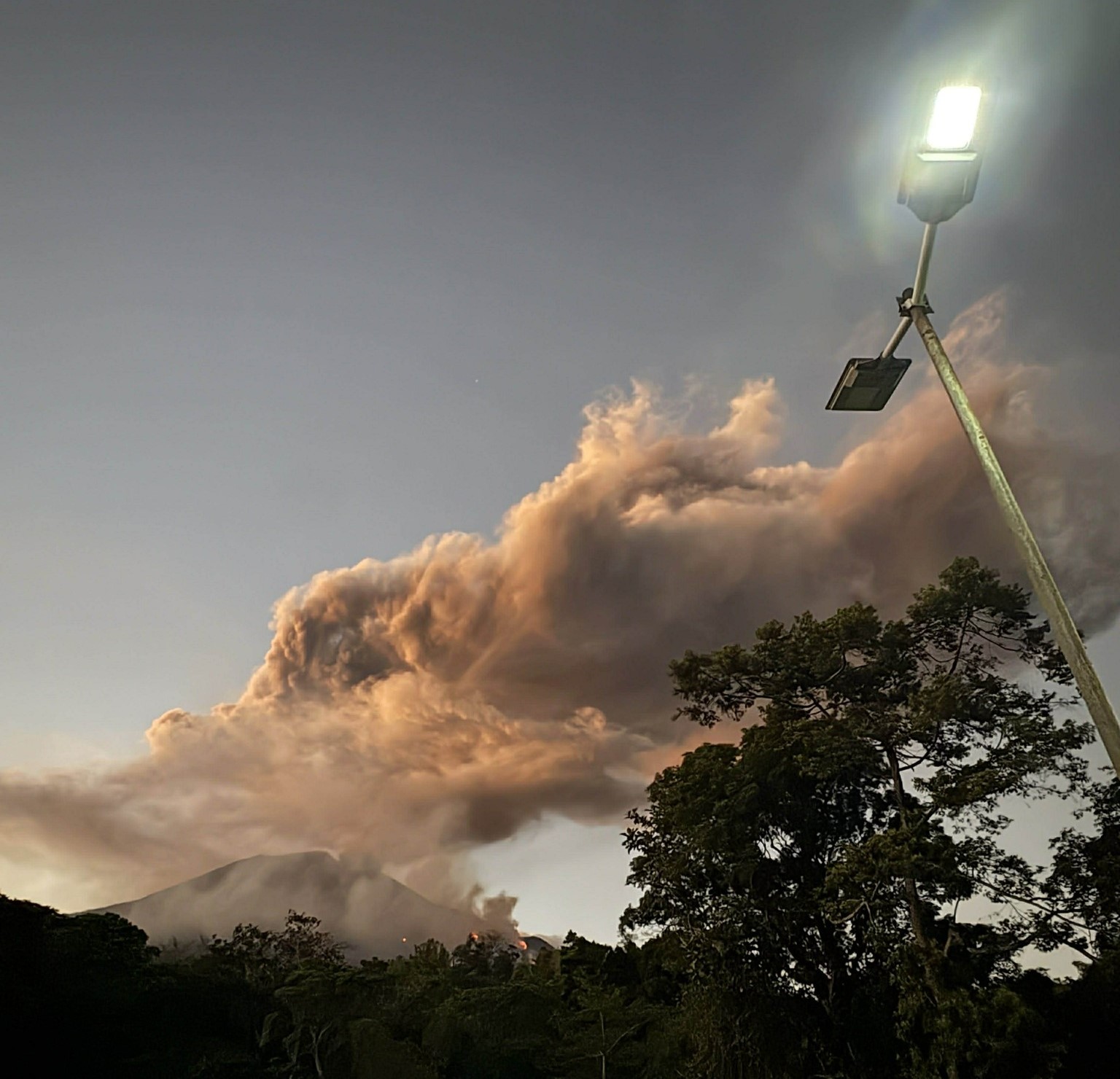
Tephra fell within a long, narrow swath to the E in at least 31 barangays in 12 municipalities and seven cities of three provinces. In Canlaon City, Vallehermoso (20 km ESE), and San Carlos City (32 km ENE) (all in Negros Oriental) the barangays of Mabigo (10 km SE), Malaiba (7 km ENE), Bapor Mayon, Macapso (21 km E), and Buluangan (21 km E) reported “heavy” ashfall, Pula and Masulog (8 km SE) reported “heavy” ashfall and ballistic blocks, and Masulog also reported lapilli fall. Ballistic rocks reportedly punctured holes through galvanized metal roofs in Masulog, Canlaon City. Moderate or uncharacterized amounts of ashfall were noted in Mabigo (10 km SE), Bayog, Panubigan (11 km E), Linothangan (8 km SE), Tagbino (16 km ESE), and Maglahos (16 km E), with trace amounts reported in Ninoy Aquino (12 km ENE) and Lumapao (8 km NE). Residents reported a sulfur odor that in some cases caused severe respiratory and eye irritation. Trace amounts of ashfall also affected several barangays in Cebu Province, including in the municipalities/cities of Toledo City (56 km E).
According to the Disaster Response Operations Monitoring and Information Center (DROMIC) there were 23 people (eight families) staying in two evacuation shelters by 18h00 on 11 July. By 18h00 on 14 July 67 people (16 families) were staying in two evacuation shelters, and 3,543 people (1,101 families) were staying with relatives or friends.
The seismic network recorded 0-8 daily volcanic earthquakes during 10-15 July and 26 on 15 July. Sulfur dioxide emissions ranged from 679 to 1,652 t/d. Volcanic emissions were mostly obscured, though plumes rose 200-500 m above the crater rim and drifted E and SE during 13-15 July. The Alert Level remained at 2 (on a scale of 0-5); the public was warned to stay out of the 4-km-radius Permanent Danger Zone (PDZ) and pilots were advised to avoid flying close to the summit.
Sources : Philippine Institute of Volcanology and Seismology (PHIVOLCS), Disaster Response Operations Monitoring and Information Center (DROMIC) , GVP.
Photo : Regine Delos Santos Tomaquin
Mexico , Popocatepetl :
The Centro Nacional de Prevención de Desastres (CENAPRED) reported that eruptive activity was low at Popocatépetl during 8-15 July. The seismic network recorded 17-196 long-period events per day, accompanied by steam-and-gas emissions and occasional ash that drifted NW, W, and WSW. On 13 July there was a moderate explosion and a period of continuous emissions lasting six hours and 46 minutes. Minor ashfall was reported in the municipalities of San Pedro Nezapa (13 km NW), Shallianquixco (18 km NW), and San Diego Huehuecalco (16 km NW), and at the Amecameca Municipal Headquarters (20 km NW).
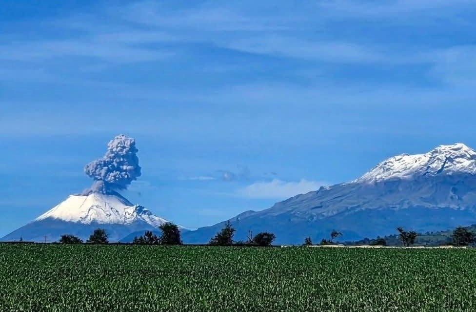
Early on 14 July there was a period of continuous emissions lasting nearly four hours, including an explosion at 0444 that ejected incandescent material onto the upper flanks. According to the Washington Volcanic Ash Advisory Center (VAAC) ash plumes visible in webcam and/or satellite images during 12-14 July rose 6.1-7.3 km (20,000-24,000 ft) a.s.l. (as high as 1.9 km above the summit) and drifted WNW, W, and WSW. The Alert Level remained at Yellow, Phase Two (the middle level on a three-color scale) and the public was warned to stay 12 km away from the crater.
Sources : Centro Nacional de Prevención de Desastres (CENAPRED), Washington Volcanic Ash Advisory Center (VAAC) GVP.