August 19 , 2026.
Italy / Sicily , Etna :
WEEKLY BULLETIN, August 10, 2026 – August 16, 2026 (issue date: August 18, 2026)
SUMMARY OF ACTIVITY STATUS
Based on monitoring data, the following observations have been noted:
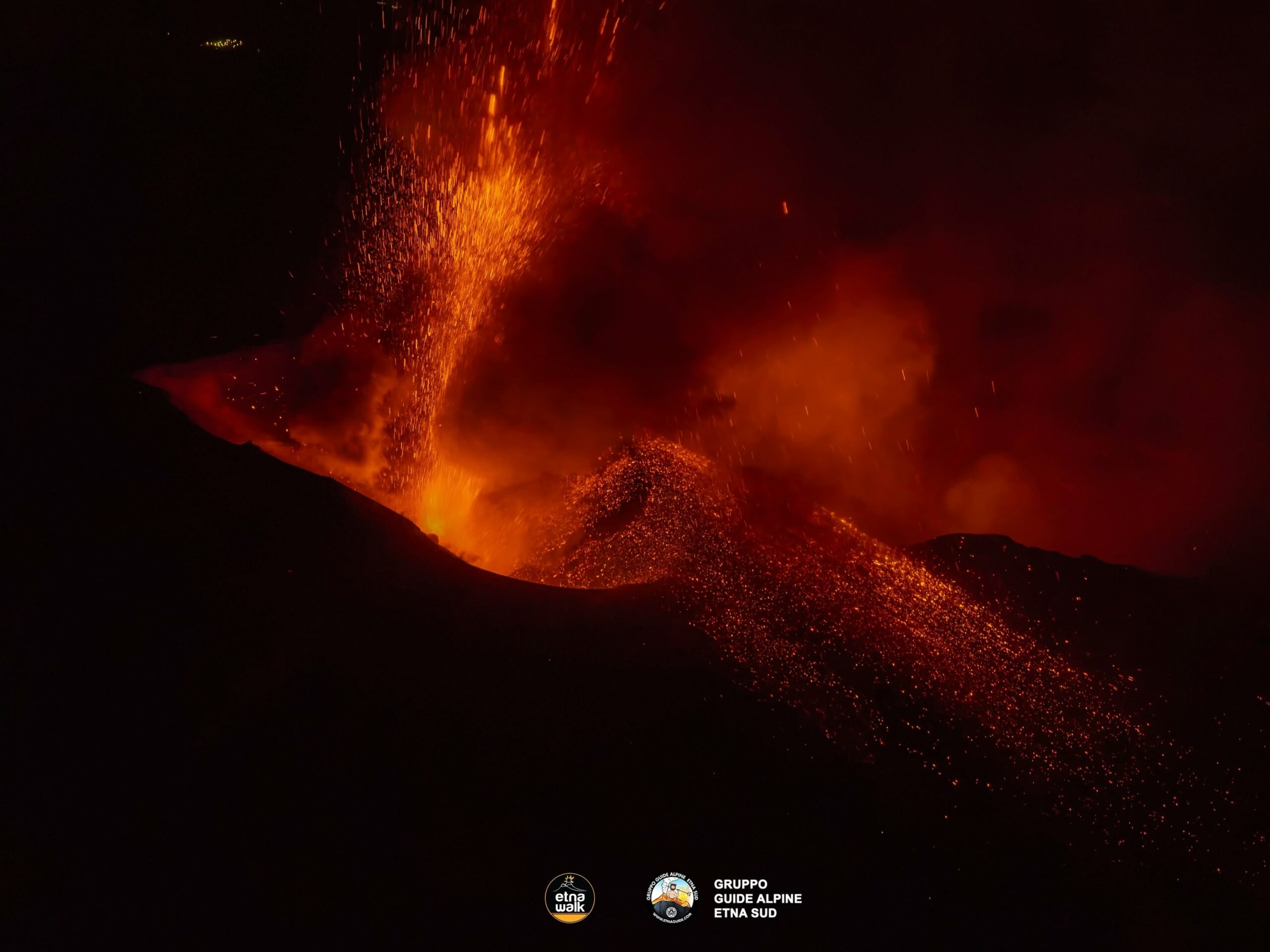
1) VOLCANOLOGICAL OBSERVATIONS: Explosive activity of varying intensity with ash emission from the Voragine crater; short-lived explosive activity and ash emissions from the Northeast Crater. Effusive activity in the Valle del Bove, fed by several eruptive vents located between 2,750 m and 1,900 m elevation.
2) SEISMOLOGY: High level of seismicity linked to fracturing along the Provenzana-Pernicana fault. Average volcanic tremor amplitude showing highly variable values—ranging from low to high depending on ongoing eruptive activity; source centroids primarily located in the Voragine crater area.
3) INFRASOUND: Infrasonic activity ranging from low to high, with more energetic phases correlated to explosive activity at the Voragine and Northeast craters.
4) GROUND DEFORMATION: Signals from ground deformation monitoring networks showed variations correlated with ongoing eruptive activity. Overall, a deflationary trend is observed across the volcanic edifice.
5) GEOCHEMISTRY: SO2 flux at a medium-high level, with daily values ranging from high to very high.
Soil CO2 flux (Etnagas network): average values.
Partial pressure of dissolved CO2 in groundwater (EtnaAcque network): no update.
Helium (He) isotope ratio at peripheral sites: no update; The latest measurement indicated high levels (July 9, 2026).
6) SATELLITE OBSERVATIONS: Satellite-observed thermal activity in the summit area was generally high to very high, coinciding with the eruptive activity that began on August 6, 2026.
7) OTHER OBSERVATIONS: The chemical composition of the gas phase associated with explosive activity at the Voragine crater indicates a contribution from the deep part of the
magmatic feeding system.
Volcanic ash samples were collected and analyzed at increasing distances from Voragine along Etna’s southern flank; results reveal a modest ground load and a composition consisting of fine ash particles.
The chemical composition of lava flow samples indicates the absence of significant input from deep-seated magma.
VOLCANOLOGICAL OBSERVATIONS
Monitoring of Etna’s volcanic activity was conducted through image analysis from the INGV-Etna Observatory (INGV-OE) camera network and daily direct field observations by INGV-OE personnel. Overall, during the period in question, Etna’s activity was characterized by persistent explosive activity at the summit craters—primarily from the Voragine crater (VOR) and, to a lesser extent, the Northeast Crater (CNE)—as well as intense effusive activity in the Valle del Bove. Regarding the effusive activity specifically, lava emission continued on August 12 from vents located at elevations of 2750 m, 2090 m, and 1900 m above sea level; the most advanced active flow front, originating from the vent at 1900 m, reached an elevation of approximately 1365 m near Rocca Capra. On the same day, the progressive cooling of the flow fronts associated with the effusive vent located at 2,360 m—which had become active on August 8—was observed.
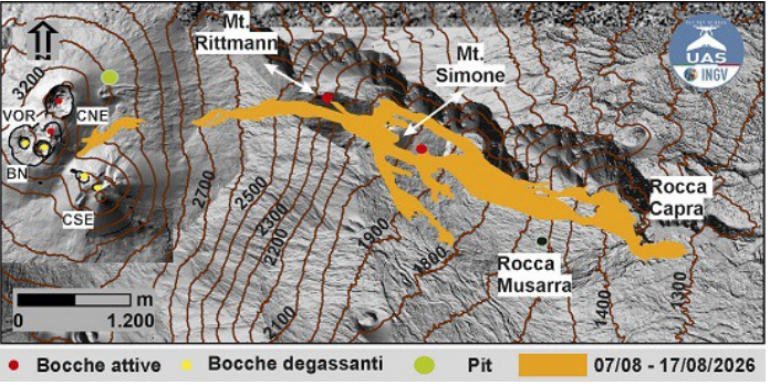
Map of the lava field updated as of August 17, 2026, created by integrating drone (UAS) surveys, Sentinel-2 satellite imagery, and field observations. The lava field is superimposed on a shaded-relief model derived from combined drone and satellite data.
On August 13, activity at the vent located at 2,090 m ceased, while effusion continued at the vents located at 2,750 m and 1,900 m. That same day, the flow front originating from the 1,900 m vent had just passed Rocca Capra, extending down to an elevation of 1,340 m. Field surveys conducted by INGV-OE personnel on August 14, 15, and 16 confirmed ongoing effusive activity at the vents located at elevations of 2,750 m and 1,900 m. Additionally, in the early hours of August 14, the formation of a collapse crater (pit crater) was observed at 3,000 m; it briefly produced intermittent degassing. On August 15, the lava fronts—partially overriding flows from previous days—reached an elevation of approximately 1,600 m near Rocca Musarra; they subsequently advanced further, reaching an elevation of 1,395 m (between Rocca delle Palombe and Rocca Musarra) on August 16. On August 17, the opening of a new effusive vent in the Valle del Bove, at an elevation of 2,350 m, caused the collapse of the eastern flank of the Monte Rittmann cone, generating a sudden emission of ash. This new vent fed a modest lava flow extending approximately 500 meters, which cooled rapidly. By the afternoon of August 17, the lava field was receding and generally cooling, although the vent located at an elevation of 1,900 m remained active and continued to feed lava flows whose fronts had reached an elevation of approximately 1,600 m. Overall, the lava erupted between August 7 and 17 covered an area of approximately 1.7 × 10⁶ m², with estimated volumes ranging from 5.6 to 7.6 × 10⁶ m³.
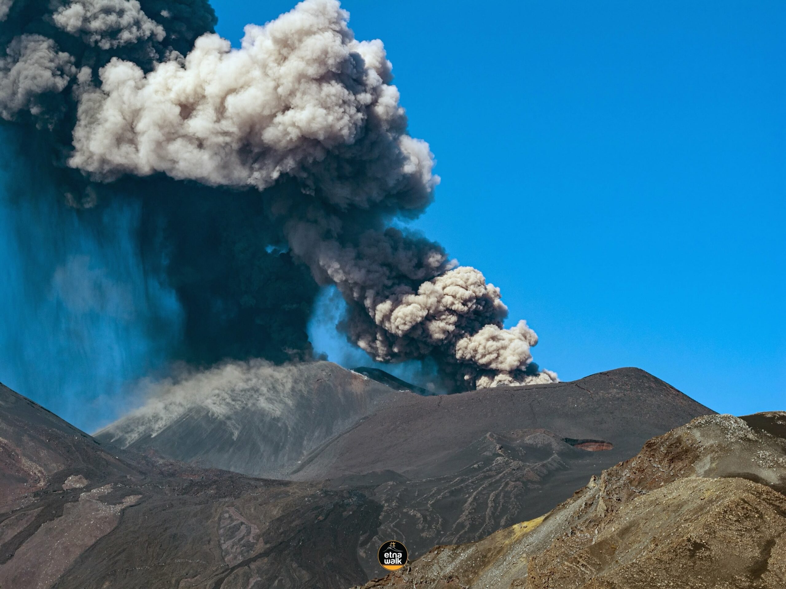
Regarding summit explosive activity, the Voragine crater (VOR) exhibited persistent explosive activity for much of the week, with ash emissions dispersing primarily toward the southern quadrants (south and southeast). This emission rate increased significantly on the afternoon of August 13. On the afternoon of August 16, the Voragine crater (VOR) displayed Strombolian activity; the following day, explosive activity varied in intensity and generated a large eruption plume reaching an altitude of approximately 6,000 m above sea level, dispersing toward the southeast.
During the observation period, the Northeast Crater experienced several episodes of intra-crater explosive activity: a brief explosion occurred on August 15, forming an ash column directed southward. Subsequently, on the morning of August 16, a series of short-lived explosions generated an ash plume that dispersed over the summit area toward the southeast. Ash emissions from this crater intensified further later that same day.
Summary as of August 18:
Lava flow originating at an altitude of 1,900 m: the flow front reached an altitude of 1,330 m, stabilizing near Rocca Capra (Valle del Bove).
New eruptive vent at an altitude of 3,100 m: opened at dawn in the upper part of the Valle del Bove; at the time of writing this bulletin, observation of this flow is impossible due to cloud cover. End of activity at the Voragine crater: explosive activity ceased at 00:00 UTC, leaving only a weak ash plume confined to the summit area.
Source : INGV
Photos : Etna Walk / gruppo guide alpine etna sud , INGV, Etna Walk .
Italy , Stromboli :
WEEKLY BULLETIN, August 10, 2026 – August 16, 2026 (issue date: August 18, 2026)
SUMMARY OF ACTIVITY STATUS
Based on monitoring data, the following observations have been noted:
1) VOLCANOLOGICAL OBSERVATIONS: Typical Strombolian eruptive activity across both crater zones. The frequency of overall explosive activity—encompassing both the North Crater zone and the Central-South Crater zone—is at a medium level; explosion intensity is medium in the North Crater zone and moderate to low in the Central-South zone.
2) SEISMOLOGY: Monitored seismic parameters show no significant variations.
3) GROUND DEFORMATION: Signals from ground deformation monitoring networks show no significant variations.
4) GEOCHEMISTRY: SO2 flux at a medium level.
Soil CO2 flux (Pizzo zone – STR02): high values. Plume C/S ratio: medium values.
Helium isotope ratio (R/Ra): decreasing from high values.
Soil CO2 flux in the San Bartolo zone: stable at high values.
5) SATELLITE OBSERVATIONS: Satellite-observed thermal activity in the summit area remained generally low, with a few anomalies of moderate intensity.
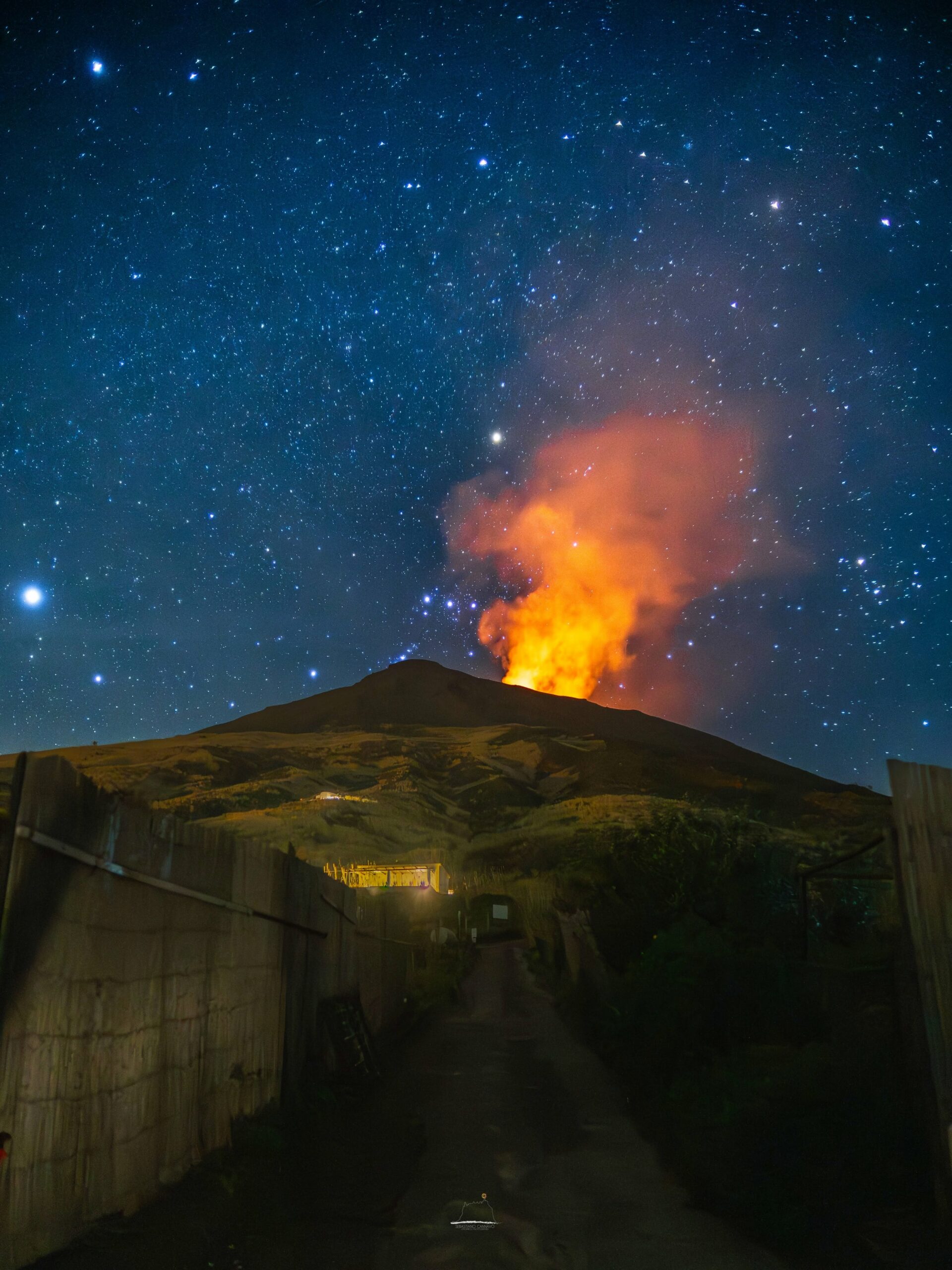
VOLCANOLOGICAL OBSERVATIONS
Observations of explosive activity captured by surveillance cameras
During the observation week, Stromboli’s eruptive activity was characterized through the analysis of images recorded by INGV-OE surveillance cameras located at an elevation of 190 m above sea level and at Punta dei Corvi (SCT-SCV and SPCT, respectively). Explosions in the North crater area (Zone N) primarily produced coarse material (bombs and lapilli); in the Central-South crater area (Zone CS), explosions produced predominantly fine material mixed with coarse material. The average explosion frequency for Zone N fell within the usual range, and intensity remained at a predominantly moderate level. In Zone CS, the average explosion frequency was low, and the intensity of explosive activity was generally low to moderate. The total average hourly explosion frequency (Zone N + Zone CS) was at a moderate level.
Source : INGV
Photo : Stromboli stati d’animo / Sebastiano Cannavo.
Kamchatka , Klyuchevskoy :
KVERT VOLCANIC ACTIVITY NOTICE (VAN)
Issued: August 19 , 2026
Volcano: Klyuchevskoy (CAVW #300260)
Current aviation colour code: ORANGE
Previous aviation colour code: orange
Source: KVERT
Notice Number: 2026-91
Volcano Location: N 56 deg 03 min E 160 deg 39 min
Area: Kamchatka, Russia
Summit Elevation: 4750 m (15580 ft)
Volcanic Activity Summary:
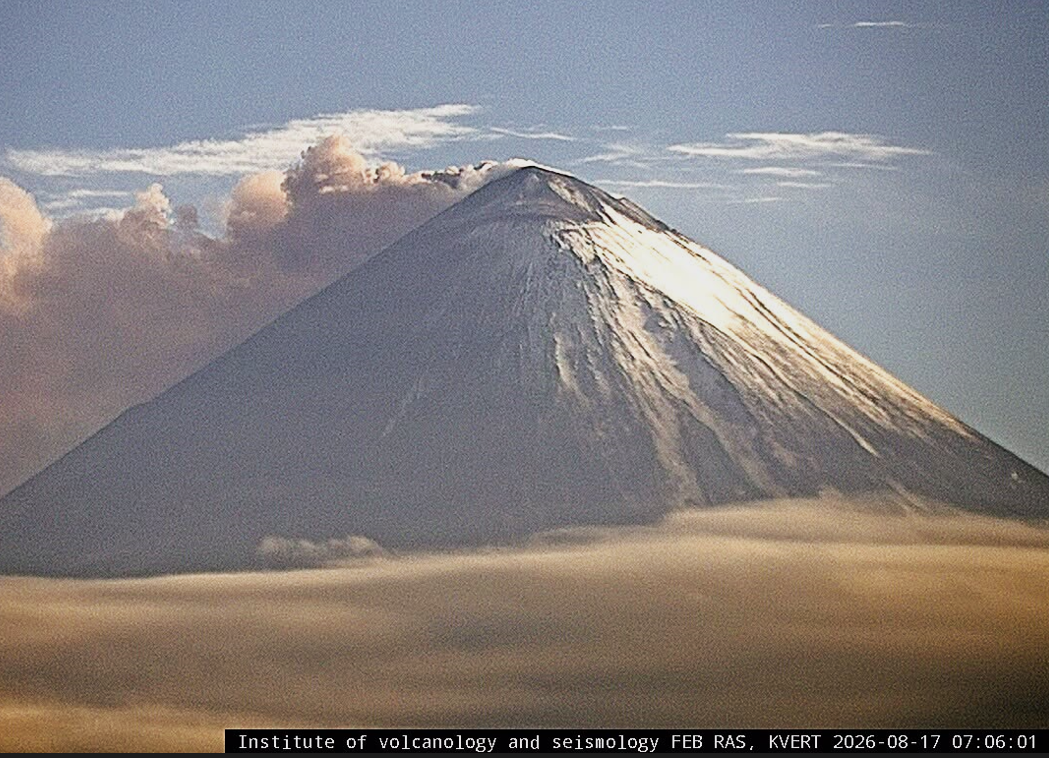
The explosive eruption of the volcano continues. According to video data, an ash rose up to 6 km a.s.l. In addition to the removal of juvenile ash from the volcanic crater, collapses of pyroclastic material from the sides of the Apakhonchich chute are observed. Satellite data by KVERT showed a thermal anomaly on the volcano; an ash plume is extending for 165 km to the east of the volcano.
The moderate explosive eruption of the volcano continues. Ongoing activity could affect low-flying aircraft.
Volcanic cloud height:
6000 m (19680 ft) AMSL Time and method of ash plume/cloud height determination: 20260819/0505Z – Video data
Other volcanic cloud information:
Distance of ash plume/cloud of the volcano: 165 km (103 mi)
Direction of drift of ash plume/cloud of the volcano: E / azimuth 90 deg
Time and method of ash plume/cloud determination: 20260819/0430Z – Himawari-9 14m15
Source et photo : Kvert.
Iceland , Reykjanes Peninsula :
Situation on the Reykjanes Peninsula . Land uplift and magma accumulation continue
Updated 18 August 2026
Land uplift at Svartsengi continues at a slow but steady rate
Seismic activity remains low
The hazard assessment remains unchanged
Land uplift and magma accumulation are continuing at Svartsengi. The development remains slow but steady. The latest model calculations indicate that approximately 29.1 million cubic metres of magma have accumulated beneath Svartsengi since the beginning of the last eruption in July 2025. The uncertainty range is between 28.3 and 29.9 million cubic metres.
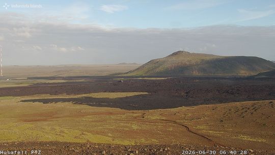
View from Húsafell towards Þorbjörn, encompassing the eruption sites.
As magma continues to accumulate and pressure increases within the system, the most likely scenario is that a magma intrusion will propagate from Svartsengi into the Sundhnúkur crater row. This could lead to a volcanic eruption. As before, the warning time could be short. Previous eruptions have had warning times ranging from approximately 20 minutes to just over four hours.
Seismic activity
Seismic activity along the Sundhnúkur crater row and near Grindavík remains low.
Source et photo : IMO.
Colombia , Puracé – Los Coconucos volcanic chain :
Popayán, August 18, 2026, 2:30 PM
Based on monitoring of the Los Coconucos volcanic chain, the Colombian Geological Service (SGC)—an agency attached to the Ministry of Mines and Energy—
reports the following:
Since the last bulletin, seismic signals associated with fluid dynamics within the volcanic conduits have remained predominant; notably, there have been episodes of tremor (TR) and, to a lesser extent, long-period (LP) events, localized beneath the Puracé volcano crater at depths of less than 2 km. Regarding seismicity linked to rock fracturing, levels have remained very low in terms of both frequency and magnitude, with activity localized 1 km beneath the crater. Slow ground deformation continues in the area encompassing the Puracé, Piocollo, and Curiquinga volcanoes.
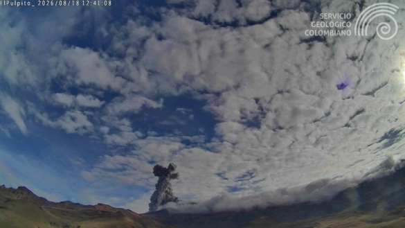
Recording of the ash emission that occurred today, August 18, 2026, at 07:39, as viewed from the El Púlpito webcam located 6 km south of Puracé volcano.
Between 2:00 PM yesterday and the time this bulletin was issued, six ash emissions were recorded—visually confirmed by monitoring webcams—reaching a maximum height of 1,100 meters above the summit of Puracé volcano.
Reports were received from residents and community observers in the rural localities (*veredas*) of Patugó, El Consuelo, Pinisigó Jigual, Alto de la Laguna, Calaguala, Coconuco, Campamento, Alto de Anambío, and Ambiró (in the municipality of Puracé), as well as from inhabitants of the municipality of Popayán. Although the number of ash emissions into the atmosphere has decreased, gas monitoring indicates that sulfur dioxide (SO2) flux values remain above the average known for this volcano, and that elevated soil carbon dioxide (CO2) concentrations persist.
Weather conditions, characterized by low cloud cover at certain times of the day, allowed for satellite observation of thermal anomalies within the crater and in the area of the lateral fumarole field of Puracé volcano.
Monitoring parameter values recorded by instruments at the volcano in recent days continue to exceed calculated baseline levels,
indicating a significant change in its dynamics; consequently, the volcano remains at the orange alert level. The public is advised not to approach the crater areas of Puracé, Piocollo, and Curiquinga volcanoes, as sudden ash or gas emissions posing a significant risk to people may occur. The alert level for volcanic activity remains at orange: Volcano showing significant changes in monitored parameters.
Source et photo : SGC