November 10 , 2026.
Chile / Argentina , Nevados de Chillan :
Volcanic Activity Report (VAR), November 6, 2026
The National Geology and Mining Service (SERNAGEOMIN) provides the following information, derived from monitoring equipment belonging to the National Volcanic Monitoring Network (RNVV) and processed and analyzed by the Southern Andes Volcanological Observatory (OVDAS).
Volcanic Activity.
During the second half of October, the Nevados de Chillán volcanic complex experienced an intensification of its explosive activity, accompanied by an increase in thermal anomalies and the height of eruptive columns. The explosions remained pulsatory in nature, with a variable pyroclast content, including the ejection of ballistically-trajectoried fragments as well as gases. The highest columns were observed on October 25 (2,300 m), 28 (2,200 m and 2,440 m), and 27 (2,000 m). Dispersion occurred primarily toward the southeast.
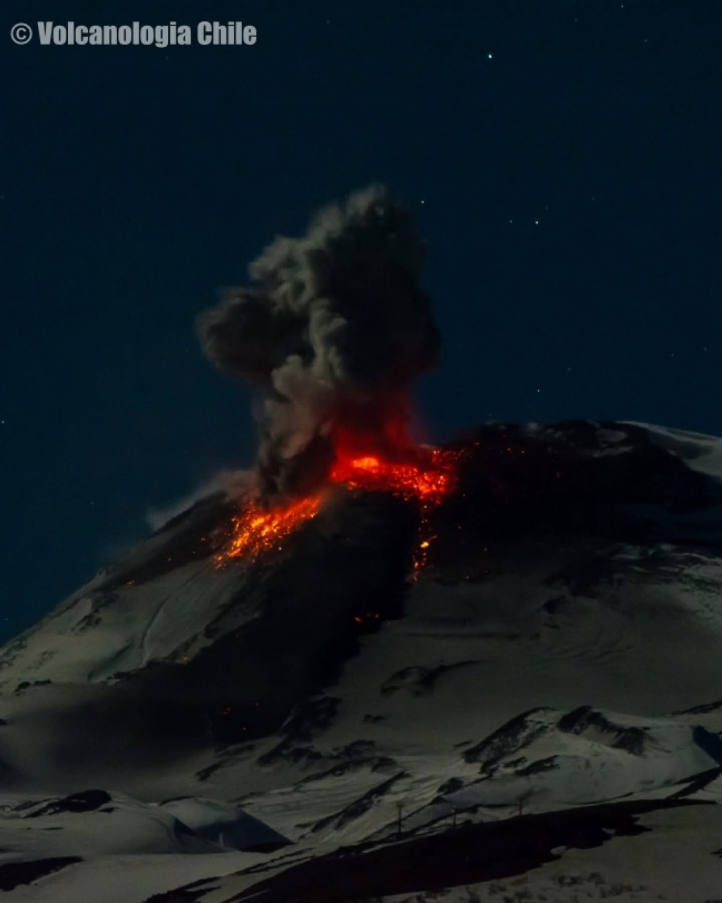
The active lava flow has continued to advance; as of today, it extends a maximum distance of approximately 880 m from the vent, with the flow front progressing at an estimated rate of about 20 m/day. Incandescence has been observed at night, both at the vent and along the flow itself, accompanied by rockfalls and collapses at the flow front. During the final days of this period, DOAS measurements indicated very low sulfur dioxide (SO₂) concentrations in the gas plume, which is consistent with the absence of SO₂ anomalies detected by satellite. Seismic activity has remained dominated by long-period (LP) events, alongside a smaller proportion of tremor-type signals—a continuation of the trend observed since late September. Seismic energy has remained relatively stable compared to the first half of October. Volcano-tectonic (VT) activity has stayed at a low level, characterized by low-magnitude events occurring at shallow depths near the active crater.
Geodetic (GNSS) data indicate that the ground has continued to show a sustained deflationary trend. Data from radar interferometry (InSAR) lacked sufficient coherence to allow for an assessment of any deformation.
Furthermore, a field visit by observatory staff confirmed that lava emission is ongoing, with occasional explosions occurring from a single source located on the western flank of the crater known as « Nuevo. »
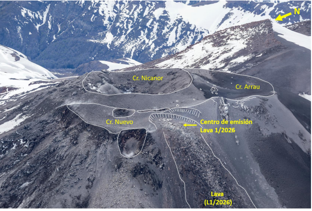
Photograph taken by Sernageomin personnel during a field visit on October 30, 2026. The arrow indicates the vent for lava flow L1.
Conclusion
The assessment of activity at the Nevados de Chillán volcanic complex, based on an analysis of data from the monitoring network, indicates eruptive activity that is proximal and low-energy in nature, consistent with a limited disturbance of the system. In this context, the volcanic activity level remains at 3 – minor eruption.
Source : Sernageomin
Photos : volcanologia Chile , Sernageomin
Japan , Iwo Jima / Ogasawara archipelago :
The Japan Meteorological Agency (JMA) and the Geospatial Information Authority of Japan acknowledged a new island formed by an eruption off Ioto Island (Iwo Jima) in the Ogasawara Islands at a regular monthly news conference on earthquakes and volcanoes on Nov. 9.
The size of the new land mass, located about 1 kilometer off Ioto, is around 300 meters from north to south at its longest point. This is about three times its size on Oct. 30, when aerial photos were taken from a Mainichi Shimbun aircraft.
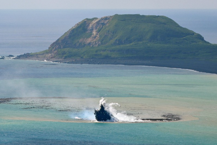
A crater erupts to the south of Ioto Island in Ogasawara, Tokyo, on Oct. 30, 2023, as seen in this photo taken from a Mainichi Shimbun aircraft. The eruption has created an islandlike land mass. Mount Suribachi is seen in the background. (Mainichi/Koichiro Tezuka)
According to the JMA, the eruption was initially seen on the sea’s surface, but now the volcano is erupting from the land area formed by the accumulation of cinders in the surrounding area. The number of eruptions accompanied by ejecta has been decreasing, but white plumes were still rising on Nov. 9.
Meanwhile, the shape of the new island has been changing daily due to wave erosion. As to whether the land will continue to exist in the future, a JMA official said, « If only a cinder eruption, as it is now, it will be eroded by waves and is unlikely to remain for a long time, but if it turns into an eruption with lava, it may remain for quite a while. »
The JMA also announced that pumice collected in late October near Torishima Island, part of the Izu Islands, « can be considered to have been produced by recent volcanic activity. » The agency said it is unclear if the pumice is related to the tsunami caused by the earthquake that struck the area near Torishima Island in early October.
Source : The Mainichi .(Japanese original by Satoshi Yamaguchi )
Photo : Mainichi/Koichiro Tezuka
Indonesia , Semeru :
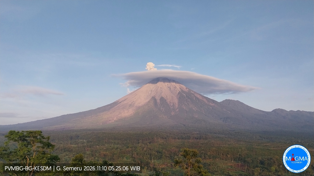
An eruption of Mount Semeru occurred on Tuesday, November 10, 2026, at 05:24 WIB; an ash column was observed, reaching approximately 800 m above the summit (about 4,476 m above sea level). This dense, gray-colored ash column drifted toward the southwest and west. The eruption was recorded by a seismograph, showing a maximum amplitude of 23 mm and a duration of 140 seconds.
Seismic observations
20 eruption-related earthquakes, with amplitudes of 10–23 mm and durations of 61–206 seconds.
3 earthquakes associated with rockfalls, with amplitudes of 2–4 mm and durations of 58–94 seconds.
6 emission-related earthquakes (gas releases), with amplitudes of 5–8 mm and durations of 53–55 seconds.
Recommendations
1. Do not conduct any activities in the southeastern sector, along the Besuk Kobokan riverbed, within a 13 km radius of the summit (the center of the eruption). Beyond this distance, the public is advised to avoid all activities within a 500-meter strip on either side of the Besuk Kobokan riverbanks, due to the risk of pyroclastic flows and lahars, which could reach a distance of 17 km from the summit.
2. Do not conduct any activities within a 5 km radius of the crater/summit of Mount Semeru, as this area is exposed to the risk of (incandescent) rock ejections.
Source et photo : PVMBG.
Italy , Campi Flegrei :
Weekly Bulletin, October 26, 2026, to November 1, 2026 (Date of issue: November 3, 2026)
SUMMARY OF ACTIVITY STATUS
Based on monitoring data, the following observations are noted:
1) SEISMOLOGY: During the week of October 26 to November 1, 2026, 42 earthquakes with a magnitude of Md ≥ 0.0 (Mdmax = 2.4 ± 0.3) were located in the Phlegraean Fields area, out of a total of 64 recorded earthquakes (-0.5 ≤ Md ≤ 2.4).
2) DEFORMATION: Since the beginning of February 2026, the average monthly uplift rate in the area of maximum deformation has been approximately 10 ± 3 mm/month.
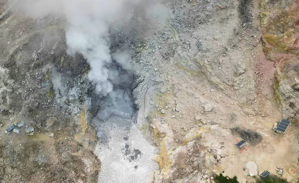
3) GEOCHEMISTRY: During the week in question, the monitored geochemical parameters remained consistent with long-term trends—previously observed (see monthly bulletins)—of heating within the hydrothermal system and increasing flux. The CO2 flux measured by the FLXOV8 station at Pisciarelli remained at high levels—though showing a slight decrease—following the increase observed in recent weeks. A moderate increase in flux was also recorded this week by a nearby station. The persistence of these values suggests an intensification of degassing in the Pisciarelli area. The temperature of the BG fumarole, located in the Solfatara crater, has shown a significant increase over the last few years; during the period under review, the average value remained stable at approximately 173°C.
GEOCHEMISTRY
During the reporting week, data continuously monitored by the geochemical network remained consistent with multi-year trends of heating and pressurization within the hydrothermal system, as well as an increase in the flux of emitted fluids (see the Monthly Bulletins).
In the Pisciarelli area (on the outer northeastern flank of the Solfatara)—which has exhibited the most pronounced variations in degassing processes in recent years—CO2 soil flux, as continuously measured by the FLXOV8 station, remained high over the past week compared to previous periods, though it showed a slight decrease. A moderate increase in flux was also recorded by another station located nearby in the same area. Should these high levels persist in the coming weeks, it would confirm a trend toward intensifying degassing activity in the Pisciarelli area.
Source et photo : INGV Vulcani
Colombia , Galeras :
San Juan de Pasto, November 3, 2026, 4:35 PM
As part of the ongoing monitoring of the Galeras volcano, the Colombian Geological Service (SGC)—an agency under the Ministry of Mines and Energy—reports the following:
During the week of October 27 to November 2, 2026, the primary variations in monitored parameters, compared to the previous week, were as follows:
● Amidst a period of low seismicity, an increase in the frequency of earthquakes was recorded, along with a significant rise in the energy released. Activity remained primarily linked to rock fracturing, with a lesser contribution from processes associated with fluid dynamics.
● The earthquakes were located predominantly to the northwest, at distances ranging from 4 to 10 km and at depths between 2 and 8 km relative to the summit (4,276 meters above sea level).
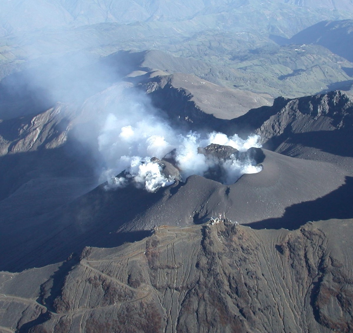
● Among the recorded earthquakes, three events with a magnitude of 2.0 or greater were notable; they occurred on November 1st at 13:04, 13:08, and 18:06, with magnitudes of 2.3, 2.7, and 2.0, respectively, and at depths of 6, 7, and 8 km. These events were located northwest of the Galeras volcano (at distances of 5.4, 4.6, and 10 km, respectively). The first two were felt in the municipality of Consacá, while the last one was not reported as being felt.
● White-colored gas emissions, occurring in bursts and rising to a low altitude, were observed; they dispersed according to the wind direction. These emissions originated primarily from the El Paisita fumarole fields to the north, the Las Chavas fields to the west, and the main crater.
● Other volcanic monitoring parameters remained stable.
Based on the assessment and correlation of the monitored parameters, the SGC recommends closely following their evolution through weekly bulletins and other information released via our official channels. It also advises adhering to the instructions provided by local and departmental authorities, as well as those from the National Unit for Disaster Risk Management (UNGRD).
Volcanic activity remains at the « Yellow » alert level, indicating an active volcano that is showing changes in the baseline behavior of monitored parameters, among other manifestations.
Source et photo : SGC.