June 12 , 2026.
Kamchatka , Sheveluch :
The Kamchatkan Volcanic Eruption Response Team (KVERT) reported continuing eruptive activity at the lava domes along the N crater floor of Young Sheveluch (on the SW flank of Old Sheveluch) during 4-10 June. A daily thermal anomaly was identified in satellite images. Ash plumes from an explosive event at 11h35 on 4 June rose 8 km (26,200 ft) a.s.l. and drifted 370 km NW and N. The ash cloud had drifted 440 km NE by the next day. Explosive and extrusive activity escalated on 6 June at 07h55; an ash plume had risen to 12 km (39,400 ft) a.s.l. by 08h00 and was drifting 10 km E based on satellite data. At 08h17 KVERT raised the Aviation Color Code (ACC) to Red (the highest level on a four-color scale).
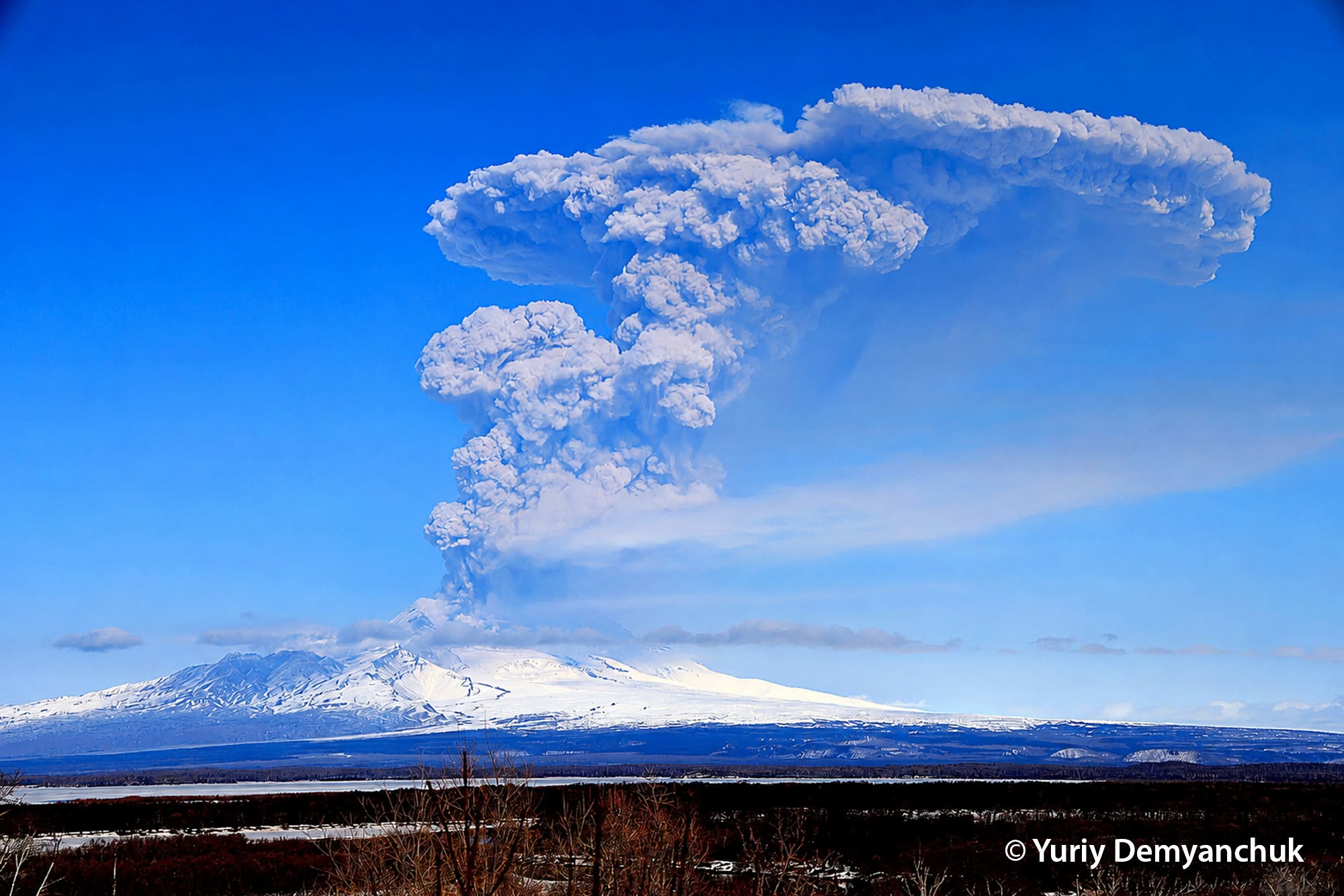
Ash plumes continued be generated and by 09h05 ash plumes were rising to10 km (32,800 ft) a.s.l. and drifting 50 km NE. An ash cloud identified in satellite images at 21h10 was 346 x 32 km in size and had drifted 68 km downwind. The ACC was lowered to Orange at 22h41 on 6 June because explosive activity had ceased. Another strong explosive event starting at 04h39 on 8 June produced ash plumes that rose 10 km a.s.l. and drifted NW. The ACC was raised to Red at 04h52. Explosions ceased and an ash cloud, 250 x 230 km in dimension, drifted 300 km NE.
The ACC was lowered to Orange at 22h21. Dates are based on UTC; specific events are in local time where noted.
Sources: Kamchatkan Volcanic Eruption Response Team (KVERT) , GVP.
Photo : Yu. Demyanchuk.
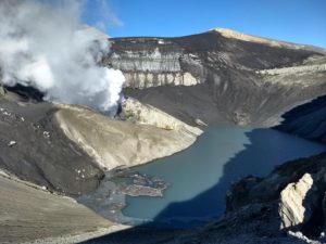
Philippines , Taal :
The Philippine Institute of Volcanology and Seismology (PHIVOLCS) reported eruptive activity at Taal during 3-10 June. The seismic network recorded 1-11 daily periods of volcanic tremor lasting one minute to three hours and 14 minutes, and as many as 11 volcanic earthquakes during 6-9 June. Daily gas-and-steam emissions rose as high as 1.5 km above the crater rim and drifted NE. Daily minor phreatomagmatic events, lasting 1-4 minutes, were recorded during 3-6 June. A phreatomagmatic event during 16h24-16h28 on 5 June generated a jetting plume to a height of 300 m as seen in images from webcams on the N and W rims.
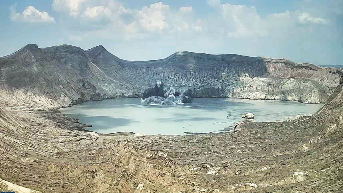
Another event the next day, during 14h55-14h56 on 6 June, produced a plume that rose 100 m above the lake. The Alert Level remained at 1 (on a scale of 0-5); PHIVOLCS reminded the public that the entire Taal Volcano Island (TVI) was a Permanent Danger Zone (PDZ) and recommended that the Main Crater and areas along the Daang Kastila fissure should remain prohibited. Pilots were warned to avoid flying over TVI.
Sources: Philippine Institute of Volcanology and Seismology (PHIVOLCS) , GVP.
Photo : Phivolcs.
Japan , Sakurajima :
The Japan Meteorological Agency (JMA) reported ongoing eruptive activity at Minamidake Crater (Aira Caldera’s Sakurajima volcano) during 1-8 June. Sulfur dioxide emissions were high, averaging 2,900 tons per day on 3 June. Very small eruptive events were detected during 1-5 June. Continuous ash emissions during 06h52-07h55 on 7 June rose as high as 1.3 km above the crater rim and drifted SE and W. A news article stated that ash fell across Kagoshima City, though this was unconfirmed by JMA. An explosion later that day, at 19h07, was recorded by the seismic network but not visually observed. An explosion at 21h41 on 8 June generated an ash plume that rose 700 m above the crater rim and drifted SE and ejected large blocks 500-700 m from the crater. The Alert Level remained at 3 (on a 5-level scale), and the public was warned to be cautious within 2 km of both the Minimadake and Showa craters.
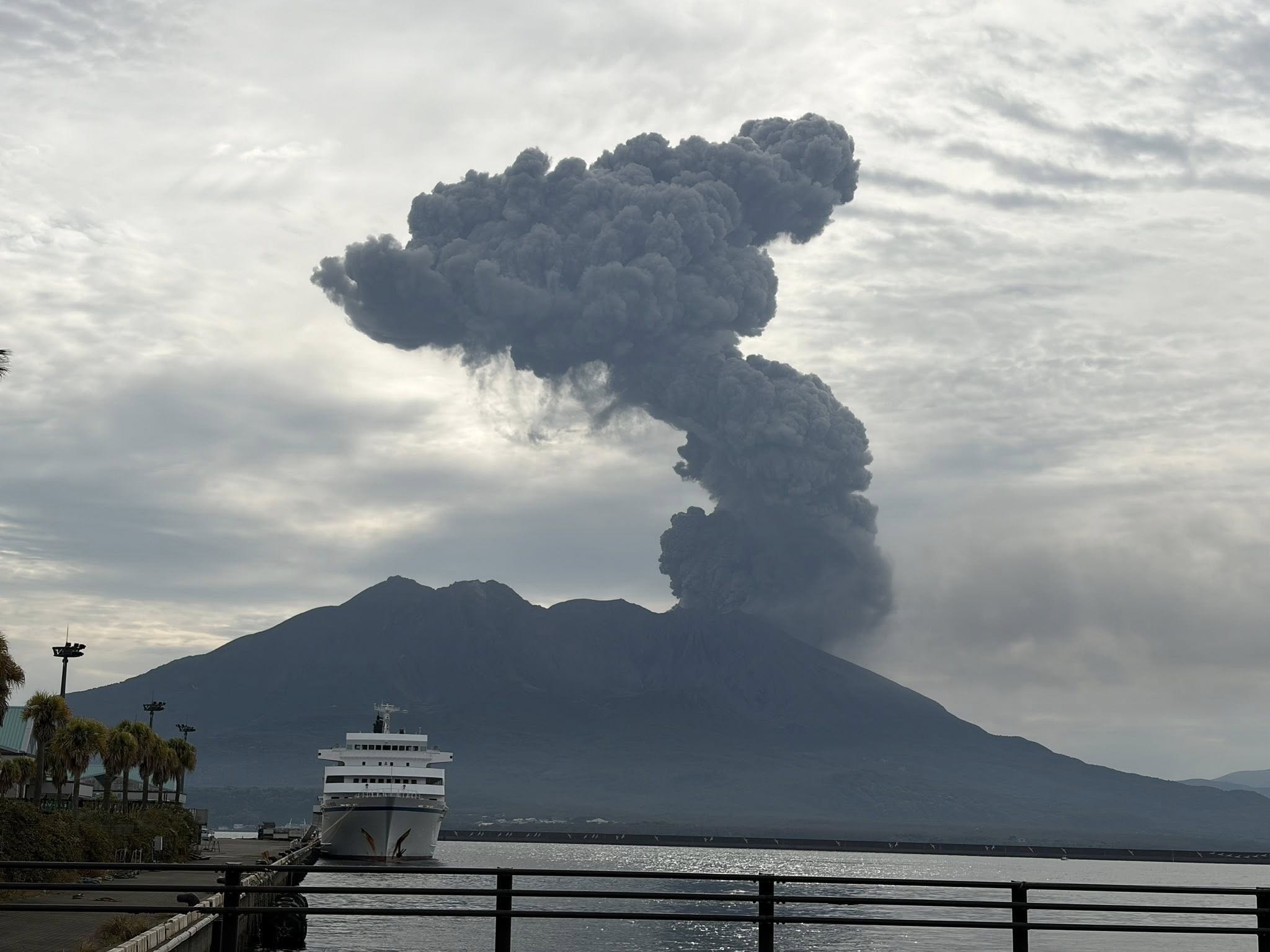
The Aira caldera in the northern half of Kagoshima Bay contains the post-caldera Sakurajima volcano, one of Japan’s most active. Eruption of the voluminous Ito pyroclastic flow accompanied formation of the 17 x 23 km caldera about 22,000 years ago. The smaller Wakamiko caldera was formed during the early Holocene in the NE corner of the caldera, along with several post-caldera cones. The construction of Sakurajima began about 13,000 years ago on the southern rim and built an island that was joined to the Osumi Peninsula during the major explosive and effusive eruption of 1914. Activity at the Kitadake summit cone ended about 4,850 years ago, after which eruptions took place at Minamidake. Frequent eruptions since the 8th century have deposited ash on the city of Kagoshima, located across Kagoshima Bay only 8 km from the summit. The largest recorded eruption took place during 1471-76.
Sources: Japan Meteorological Agency (JMA) , GVP.
Photo : Hanna Hanna.
Indonesia , Lewotobi Laki-Laki :
An eruption of Mount Lewotobi Laki-laki occurred on Friday, June 12, 2026, at 11:48 AM WITA. The observed ash column rose approximately 1,000 meters above the summit (approximately 2,584 meters above sea level). This ash column was gray and very dense, oriented to the west and northwest. The eruption was recorded by a seismograph, with a maximum amplitude of 29.6 mm and a duration of 42 seconds.
Seismic Observations:
5 eruption earthquakes with amplitudes ranging from 5.9 to 47.3 mm and durations of 37 to 57 seconds.
2 emission earthquakes with amplitudes ranging from 2.9 to 4.4 mm and durations of 31 to 32 seconds.
3 non-harmonic tremors with amplitudes between 4.4 and 7.4 mm and a duration of 85 to 135 seconds.
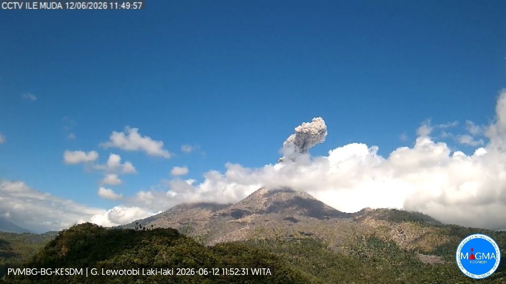
The Pusat Vulkanologi dan Mitigasi Bencana Geologi (PVMBG) reported that activity continued at Lewotobi Laki-Laki during 2-10 June. Two dense gray ash plumes rose 600 m and 1,000 m above the summit and drifted in multiple directions on 2 June. A few dense gray ash plumes were visible on 4 June rising 800-1,200 m above the summit and drifted SW, W, and NW. Multiple daily dense gray ash plumes rose as high as 2.5 km above the summit and drifted SW, W, and NW during 5-10 June. Incandescence at the summit and incandescent material being ejected above the summit and onto the flanks were visible in webcam images at 18h28 and 22h50 on 5 June. Summit incandescence was visible in webcam images on 6 June (at 00h49, 01h17, and 02h13), and 10 June (at 22h30 and 23h55). The Alert Level remained at 3 (on a scale of 1-4), and the public was warned to stay 5 km away from the center of Laki-Laki.
Sources: Pusat Vulkanologi dan Mitigasi Bencana Geologi (PVMBG, also known as CVGHM) , GVP.
Colombia , Galeras :
San Juan de Pasto, June 9, 2026, 4:50 PM
Regarding the monitoring of activity at the Galeras volcano, the Colombian Geological Survey (SGC), an agency under the Ministry of Mines and Energy, reports the following:
During the week of June 2-8, 2026, the main variations in monitored parameters, compared to the previous week, were as follows:
● Volcanic activity remained low, with an increase in seismic activity and energy released. Seismicity was primarily related to rock fracturing within the volcanic edifice.
● Most of the fracturing occurred near the main crater, with some other fracturing taking place in the northeast sector of the volcanic edifice, less than 20 km away. Depths were less than 14 km below the summit of the Galeras volcano (4,200 m altitude), with magnitudes less than 2.3.
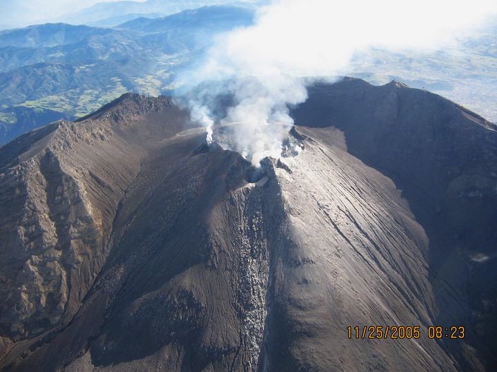
Throughout the week, plumes of white gas were observed, at low altitude and with variable dispersion depending on wind direction, originating primarily from the fumarole fields of El Paisita to the north, Las Chavas to the west, and the main crater.
Other volcanic monitoring parameters remained stable.
Geological Service of Colombia (SGC) recommends closely monitoring developments through weekly bulletins and other information published by its official channels, as well as instructions from local and departmental authorities and the National Unit for Disaster Risk Management (UNGRD).
Volcanic activity remains at the yellow alert level: Active volcano with changes in the baseline behavior of monitored parameters and other manifestations.
Source et photo : SGC.