May 12 , 2026.
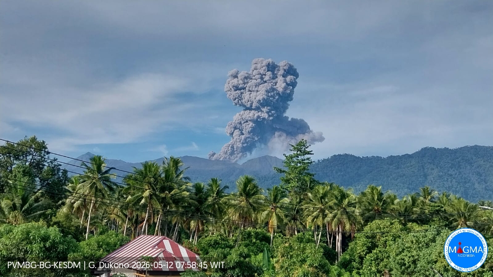
Indonesia , Dukono :
Latest information on the status of Mount Dukono (May 11, 2026).
Volcanic activity at Mount Dukono, located on Halmahera Island in North Maluku Province, remains high, and the alert level remains at II. Situated in the districts of Galela and Tobelo, the volcano experienced a recorded eruption on May 8, 2026, with a volcanic column reaching 10,000 meters above the summit. The eruption alert zone for Mount Dukono has been extended to 4 km from the epicenter and remains at Level II as of December 11, 2024, at 3:00 PM (Jakarta local time).
Volcanic activity at Mount Dukono remains marked by the eruptions recorded on May 9 and 10, 2026, with 92 and 63 eruptions respectively, whose plumes reached heights ranging from 600 to 3,000 meters. The most recent eruption occurred on May 11, 2026, at 6:30 a.m. (local time), recorded on a seismogram with a maximum amplitude of 20 mm and a duration of 78.08 seconds. The observed plume was gray to black, thick, and rose approximately 2,700 meters above the summit. As the ash plume spreads northward, residential areas and the city of Tobelo are at risk of volcanic ashfall. This situation increases risks to public health and disrupts daily activities, including transportation and environmental hygiene.
The Center for Volcanology and Geological Hazard Mitigation (PVMBG), the geological agency, advises the public, tourists, and climbers to avoid all activities within a 4-kilometer radius of the Malupang Warirang crater, the center of volcanic activity. In addition to the direct threat of ejected rock and ash, the public is also advised of the potential secondary risk of lahar flows, particularly during the rainy season. These flows can travel down the Mamuya River to the north and the Mede and Tauni Rivers to the northeast, which originate at the summit of Mount Dukono.
Regional authorities, including the Regional Disaster Management Agency (BPBD) of North Maluku Province and North Halmahera District, are urged to maintain active coordination with the Dukono Volcano observation post located in Mamuya Village.
Mount Dukono’s activity is assessed periodically or at any time in the event of significant changes. The public is advised to remain calm and vigilant, and to follow the instructions of the authorities for everyone’s safety.
Source et photo : : PVMBG.
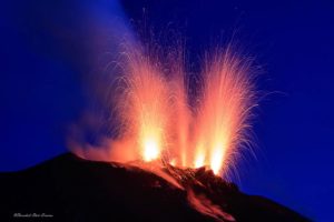
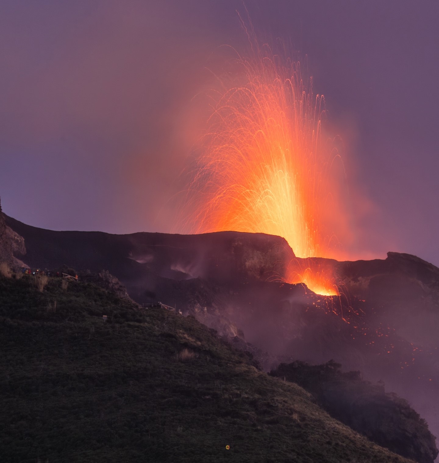
Italy , Stromboli :
Stromboli Activity Update, May 11, 2026, 08:56 (06:56 UTC).
The National Institute of Geophysics and Volcanology, Etna Observatory, announces that analysis of surveillance camera images shows that the previously reported effusive activity (Stromboli Update of May 10, 2026, at 23:37) has ended and that the lava field is cooling. Ordinary Strombolian activity continues in the North and Central-South crater areas, and ejections of varying intensity are being observed in the North crater area.
From a seismic perspective, since this morning, the average amplitude of volcanic tremor has stabilized at medium to high values. No significant changes have been reported in the frequency and amplitude of explosion earthquakes.
No significant distortion has been recorded in the high-frequency GNSS signals.
Further updates will be provided soon.
Source : INGV.
Photo : Stromboli stati d’animo / Sebastiano Cannavo.
Chile / Argentina , Laguna del Maule :
SPECIAL REPORT ON VOLCANIC ACTIVITY, May 10, 2026
The Argentine Geological and Mining Service (SEGEMAR), through its Argentine Volcanological Observatory (OAVV), reports that today, Sunday, May 10, 2026, starting at 11:16 a.m. local time (2:16 p.m. UTC), volcanic monitoring stations located near the Laguna del Maule volcanic complex recorded an increase in the frequency of volcano-tectonic (VT) earthquakes associated with rock fracturing within the volcanic system. At the time of publication of this report, a total of one hundred and fifty (150) events have been recorded, classifying this episode as a seismic swarm.
High-Energy Event Information
Origin Time: 1:09 PM local time (4:09 PM UTC)
Latitude: -36.083°
Longitude: -70.477°
Depth: 4.0 km
Local Magnitude: 2.4 (ML)
COMMENTS:
At the time of publication of this report, events with similar characteristics continue to be recorded. It should be noted that no surface activity or variation in other monitoring parameters has been detected at the volcanic complex. This event had no impact on Argentina territory, and no reports have been received from neighboring populations in Argentina.
CONCLUSIONS:
The technical alert level remains in effect, and monitoring of the volcano continues in constant communication with the Southern Andes Volcanological Observatory (OVDAS) of Chile. Any changes will be reported.
Source : SEGEMAR.
Photo : OAVV.
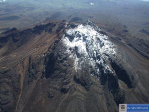
Colombia , Cumbal :
San Juan de Pasto, May 5, 2026, 4:17 PM
Regarding the monitoring of activity at the Cumbal Volcanic Complex (CVC), the Colombian Geological Survey (SGC), an agency under the Ministry of Mines and Energy, reports the following:
During the week of April 28 to May 4, 2026, the main variations in monitored parameters compared to the previous week were as follows:
● The number of earthquakes remained stable, with a decrease in their energy release. The most significant seismic contribution remained related to rock fracturing processes within the volcanic edifice. The maximum magnitude for this type of event was 1.1.
● Weak gas emissions were recorded at the Rastrojos, Boca Vieja, and El Verde fumaroles, with varying dispersion depending on wind patterns.
● Other volcanic monitoring parameters remained stable.
● In light of the above, the Colombian Geological Survey (SGC) recommends closely monitoring the situation through weekly bulletins and other information published via its official channels, as well as following the instructions of local and departmental authorities and the National Disaster Risk Management Unit (UNGRD).
Volcanic activity remains at the yellow alert level: active volcano exhibiting changes in the baseline behavior of monitored parameters and other manifestations.
Source et photo : SGC.
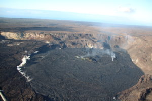
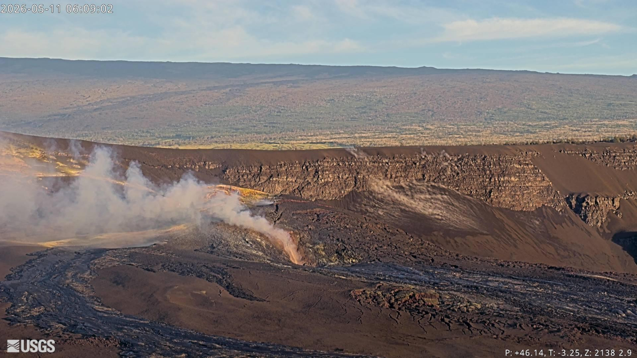
Hawaii , Kilauea :
HAWAIIAN VOLCANO OBSERVATORY DAILY UPDATE , U.S. Geological Survey
Monday, May 11, 2026, 9:05 AM HST (Monday, May 11, 2026, 19:05 UTC)
19°25’16 » N 155°17’13 » W,
Summit Elevation 4091 ft (1247 m)
Current Volcano Alert Level: ADVISORY
Current Aviation Color Code: YELLOW
Summary:
The eruption at the summit of Kīlauea is currently paused. The forecast window for the onset of episode 47 fountaining is May 12 – May 15, 2026.
Overview:
The eruption at the summit of Kīlauea is currently paused. Consistent degassing continue from both north and south vents. Overnight, south vent had strong consistent glow with frequent bursts of large flames, and north vent had weak consistent glow. The forecast window for episode 47, based on tilt data, suggests that lava fountaining will occur again sometime between Tuesday, May 12 and Friday, May 15. This window may be adjusted based on continuing observations.
No significant activity has been noted along Kīlauea’s East Rift Zone or Southwest Rift Zone.
Summit Observations:
Degassing continues at both vents. Overnight, south vent had strong consistent glow with frequent bursts of large flames, likely caused by the ignition of volcanic gases escaping the vent, and north vent had weak consistent glow observed on webcams.
Seismic tremor continues during the current pause. There were no regular tremor bursts. Earthquake activity at the summit during and after episode 46 has been low, with no small earthquakes recorded in the past day.
The Uēkahuna tiltmeter (UWD) recorded about 14.0 microradians of deflationary tilt during episode 46. Since the end episode 46, summit inflation has resumed, with the same tiltmeter recording about 11.4 microradians of inflationary tilt as of this morning.
With the eruption now paused, the SO2 emission rate is likely now varying within a typical range of 1,000 to 5,000 tonnes per day. Current summit wind conditions are light to moderate from the north northeast and carrying the gas plume to the southwest.
Rift Zone Observations:
Rates of seismicity and ground deformation remain low in the East Rift Zone and Southwest Rift Zone. SO2 emissions from the East Rift Zone remain below the detection limit.
Source et photo : HVO.