May 3 , 2026.
Philippines , Mayon :
Date: May 3, 2026. Alert Level: 3 (Intensified Magmatic Agitation)
Eruption
Lava effusion with flows in the Basud (3.8 km), Bonga (3.2 km), and Mi-isi (1.6 km) ravines, accompanied by minor episodic Strombolian activity and brief lava fountains.
Activity
Successive pyroclastic density currents (PDCs) along the Mi-isi ravine in the pyroclastic pulsation zone (PPZ), and ashfall on the southwest slopes.
Seismicity
32 volcanic earthquakes, including 25 volcanic tremors (lasting 2 to 15 minutes); 284 rockfalls and 14 PDC signals.
Crater glow visible to the naked eye, Sulfur dioxide flux: 1,586 tonnes/day (May 1, 2026). Short-term deflation of the edifice, accompanied by short-term inflation on its Northeast flank.
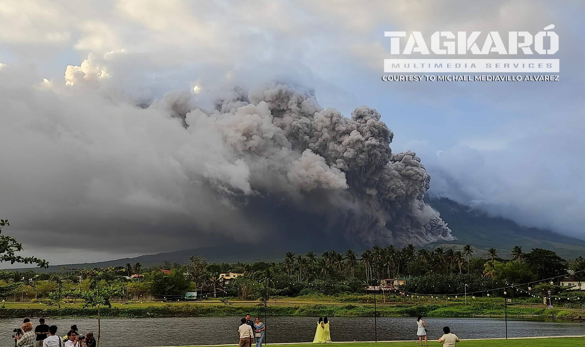
Heavy ashfall blanketed several towns in Albay’s third district on Saturday, following a Strombolian eruption and ongoing pyroclastic flows from Mayon volcano, local officials said.
At least 17 barangays (villages) in the city of Guinobatan were severely affected, with visibility near zero in some areas, Guinobatan Mayor Gemma Ann Ongjoco told the Inquirer newspaper.
Mayon volcano remained at alert level 3 after spewing a cloud of ash and debris over the Bicol region, seismologists from the Philippine Institute of Volcanology and Seismology (Phivolcs) said.
In its 24-hour observation bulletin, dated Sunday, May 3, Phivolcs indicated that the lava flows had reached 3.8 kilometers in the Basud ravine, 3.2 kilometers in the Bonga ravine and 1.6 kilometers in the Mi-isi ravine.
Sources : Phivolcs , Inquirer , Philstar .
Photo : Michael Mediavillo Alvarez.
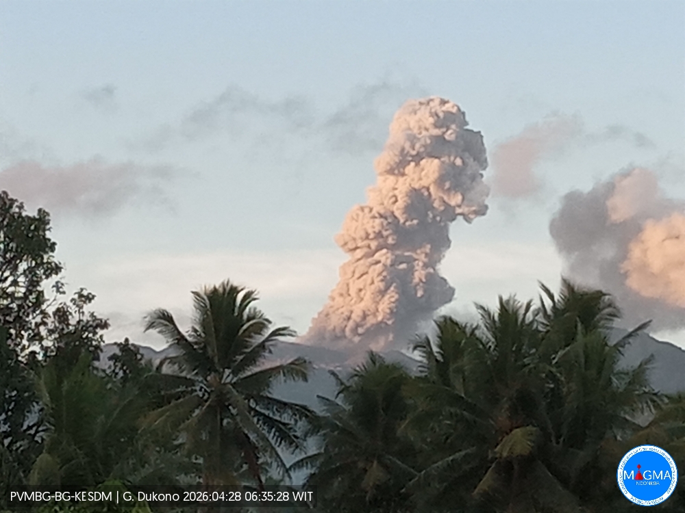
Indonesia , Dukono :
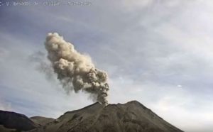
An eruption of Mount Dukono occurred on Sunday, May 3, 2026, at 05:49 WIT, with an observed ash column height of approximately 2,000 m above the summit (approximately 3,087 m above sea level). This ash column, white to gray in color, was highly intense and directed northeast. At the time of writing, the eruption was still ongoing.
Seismic Observations
72 eruption earthquakes with amplitudes ranging from 6 to 30 mm and durations from 40.53 to 66.36 seconds.
Continuous tremor with amplitudes ranging from 1 to 10 mm, primarily 5 mm.
Recommendations
(1) Communities living near Mount Dukono and visitors/tourists are advised to refrain from any activity, climbing, or approaching the Malupang Warirang crater within a 4 km radius.
(2) Given that volcanic ash eruptions are periodic and that ash dispersion depends on wind direction and strength, making the ash cover area unstable, communities living near Mount Dukono are advised to always have masks/face coverings available to protect themselves from respiratory risks associated with volcanic ash.
Source et photo : PVMBG.
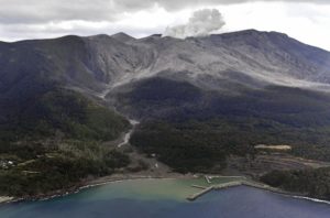
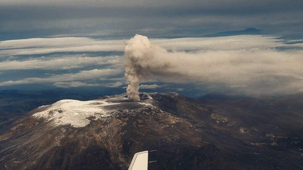
Colombia , Nevado del Ruiz :
Manizales, April 28, 2026, 7:45 PM
Regarding the monitoring of activity at the Nevado del Ruiz volcano, the Colombian Geological Survey (SGC), an agency under the Ministry of Mines and Energy, reports the following:
During the week of April 21-27, 2026, the volcano continued to exhibit unstable behavior. Compared to the previous week, the main variations in monitored parameters were as follows:
– Seismic activity associated with rock fracturing processes within the volcanic edifice changed slightly, characterized by a decrease in the number of recorded earthquakes and an increase in the seismic energy released. The earthquakes were primarily located in the Arenas crater and on the southwest flank of the volcano, within 4 km of the crater. Fewer and more scattered earthquakes were recorded in other areas, up to 10 km from the crater. In general, the depth of the events varied from less than 1 km to 7 km below the reference level. The maximum recorded magnitude was 1.5, corresponding to the earthquake that occurred on April 23 at 1:27 a.m., 3 km south-southwest of the Arenas crater and at a depth of 4 km.
Seismicity associated with fluid dynamics in volcanic conduits increased slightly in the number of recorded earthquakes, while maintaining similar levels of released seismic energy. These seismic signals corresponded to short-duration, low-energy events. No long-duration events were recorded during this week, and no pulsatile ash emissions or apparent temperature variations in emitted materials, associated with this type of seismic signal, were confirmed.
The volcano continued to emit water vapor and volcanic gases, primarily sulfur dioxide (SO₂), into the atmosphere from the Arenas crater. The estimated SO₂ flux associated with degassing processes remained variable, with low values, and decreased compared to the previous week. This decrease is attributed, in part, to the prevailing wind direction toward the volcano’s eastern flank, where monitoring station coverage is less extensive. Further monitoring, conducted using satellite data platforms, also revealed low levels of SO₂ emissions.
– The height of the gas and water vapor plume remained primarily between 300 and 500 m above the volcano’s summit, and occasionally between 700 and 1,000 m. The latter height was observed on the afternoon of April 27. The plume’s dispersion direction was variable, with a preference for the southeast and northeast flanks and, to a lesser extent, the east-southeast and east-northeast flanks of the volcano.
Monitoring of thermal anomalies at the bottom of the Arenas crater, using satellite platforms, showed that the energy levels of these anomalies remained low.
Source et photo : PVMBG.
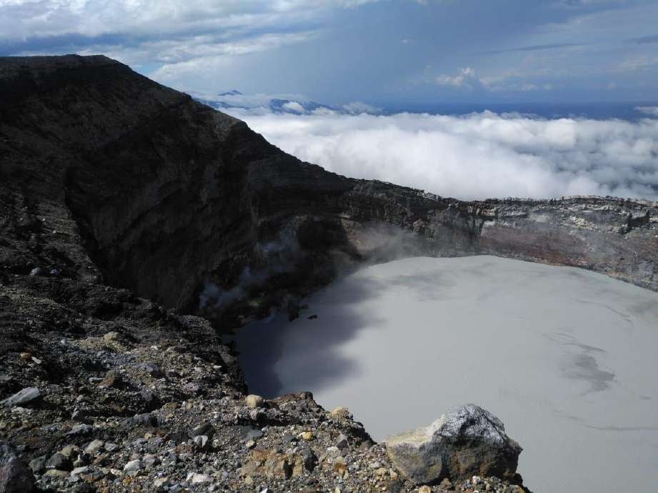
Costa Rica , Rincón de la Vieja :
Latitude: 10.83°N;
Longitude: 85.34°W;
Altitude: 1916 m
Current Activity Level: Alert.
Two eruptions were recorded this week. The one on April 27 at 3:03 a.m. was the most powerful of the year. However, it did not generate any lahars. On April 28, residents of the communities of El Gavilán and Buenos Aires reported a change in color of the Azul and Pénjamo rivers after heavy rains at the summit carried sediment from the lake and/or ash into the rivers. The background tremor remains of variable amplitude and occurs at high frequencies (2.5 and 6 Hz). Brief tremors, of varying amplitude and duration, are also being recorded, with a lower frequency content (1-3 Hz) than that of the background tremor.
An increase in the number of long-period events is observed. The occurrence of stable-magnitude tornillo-type events continues. The dominant frequency of these events continues to decrease this week. Five distal volcano-tectonic earthquakes and one proximal earthquake were recorded this week. The geodetic network is not recording significant deformation. However, the summit area shows a slight upward trend. The MultiGAS station continues to record low SO₂ concentrations. This week, DOAS stations recorded an average SO₂ flux of approximately 80 t/d, lower than the previous week (approximately 150 t/d). The last detection of SO₂ in the atmosphere by the SENTINEL satellite, emitted by the Rincón de la Vieja volcano, dates back to September 7, 2025.
Source : Ovsicori .
Photo : Waldo Taylor de ICE.
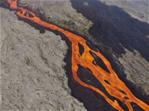
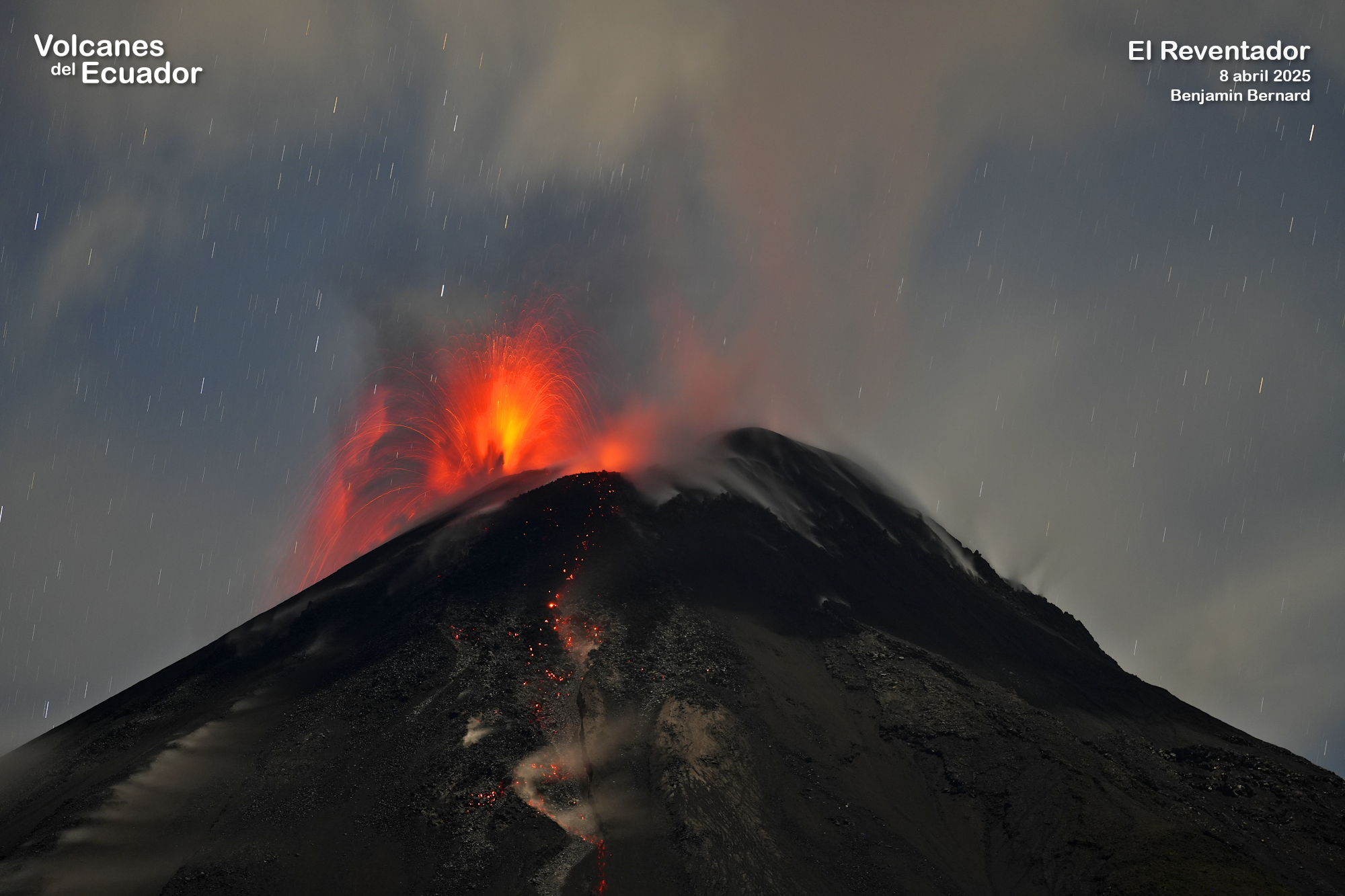
Equateur , El Reventador :
REVENTADOR VOLCANO DAILY STATE REPORT, Saturday, May 2, 2026.
Information Geophysical Institute – EPN.
Surface Activity Level: High, Surface Trend: No Change
Internal Activity Level: Moderate, Internal Trend: No Change
From May 1, 2026, 11:00 AM to May 2, 2026, 11:00 AM:
Seismicity:
Explosion (EXP) 94
Long Period (LP) 10
Emission Tremor (TREMI) 15
Harmonic Tremor (TRARM) 9
Rain/Lahars:
Precipitation has been recorded in the volcano area, but it has not generated any mudflows or debris. In the event of heavy rain, the accumulated material could be remobilized, causing mudflows and debris flows that would cascade down the volcano’s flanks and into nearby rivers.
Ash Plume:
Since yesterday afternoon, the monitoring camera system has recorded several emissions of gas and ash reaching an altitude of 400 to 700 meters above the crater, drifting west and northwest. In addition, the VAAC agency in Washington has issued a report concerning emissions of gas and ash reaching an altitude of 1,000 meters above the crater, also drifting northwest.
Other Monitoring Parameters:
The MIROVA-VIIRS 750 satellite system recorded a thermal anomaly in the last 24 hours.
Observation:
Overnight and early this morning, several episodes of incandescent material falling from the volcano’s flanks were observed, reaching an altitude of 1,000 meters below the crater. At the time of writing, the volcano remains shrouded in clouds.
Alert Level – SGR: Orange
Source : IGEPN.
Photo : Benjamin Bernard , Volcanes del equateur