April 7 , 2026.
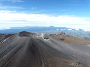
Hawaii , Kilauea :
HAWAIIAN VOLCANO OBSERVATORY DAILY UPDATE , U.S. Geological Survey
Monday, April 6, 2026, 8:44 AM HST (Monday, April 6, 2026, 18:44 UTC)
19°25’16 » N 155°17’13 » W,
Summit Elevation 4091 ft (1247 m)
Current Volcano Alert Level: WATCH
Current Aviation Color Code: ORANGE
Activity Summary:
Small precursory overflows continue this morning from the south vent. The summit slowly deflated for most of the past 24 hours, which may delay the onset of episode 44 lava fountaining to later within the forecast window. Additional overflows and associated spattering are likely to continue until the start of episode 44 fountaining. The current forecast window for episode 44 is April 6-14.
No significant activity has been noted along Kīlauea’s East Rift Zone or Southwest Rift Zone.
NOTE:
The National Weather Service (NWS) issued a Special Weather Statement yesterday about the potential for tephra fall from episode 44 in downwind communities especially if it begins in the middle to end of next week when the NWS has forecast possible southerly winds.
Summit Observations:
Precursory spattering and lava flows from the south vent began the morning of April 3 and continued over the past 24 hours. In total, nearly 50 overflows have occurred from the south vent since the morning of April 3, with accompanying small dome fountains about 3-6 feet (1-2 meters) high. These events were followed by more vigorous spattering when lava drains back into the south vent. The north vents continued to glow strongly and continuously overnight.
Seismic tremor is continuous with frequent small, poorly-defined bursts possibly related to rise and fall of magma in the vents.
Summit tiltmeters UWD and SMC recorded mostly inflation since the end of episode 43, with a switch to mild deflation over the past 24 hours. The UWD tiltmeter recorded an estimated 24.4 microradians of inflationary tilt since the end of episode 43, with a switch to deflation around 6 a.m. HST this morning. Since yesterday morning, UWD tiltmeter has recorded a total of about 1 microradian of deflation.
During eruptive pauses, like the current conditions, the SO2 emission rate from the summit has varied within a typical range of 1,000 to 5,000 tonnes of SO2 per day. Winds remain steady at around 10-15 miles per hour out of the northeast.
Rift Zone Observations:
Rates of seismicity and ground deformation remain low in the East Rift Zone and Southwest Rift Zone. SO2 emissions from the East Rift Zone remain below the detection limit.
Source et photo : USGS.
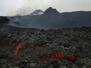
La Réunion Island , Piton de la Fournaise :
Press release from the Paris Institute of Earth Physics / Piton de la Fournaise Volcanological Observatory, April 7, 2026 – 8:45 a.m. local time – 4:45 a.m. UTC
Tremor
A tremor* has been recorded since 8:40 p.m. (local time, 4:40 p.m. UTC) on April 3. The source of this tremor is located on the east-southeast flank of the volcano and is positioned in the same location as during the eruptive activity phases from February 23 to April 3.
Over the last 24 hours, the amplitude of the tremor decreased slightly before stabilizing again over the last 8 hours. Weak « gas piston » sequences have been recorded. This tremor is not accompanied by surface lava emissions. Only a slight plume of gas is emitted from the eruptive fissure associated with the activity from February 13 to April 3, located at an altitude of 2056 m on the east-southeast flank of the volcano. This tremor nevertheless indicates the presence of magma at a shallow depth; thus, a resumption of lava emissions cannot be ruled out.
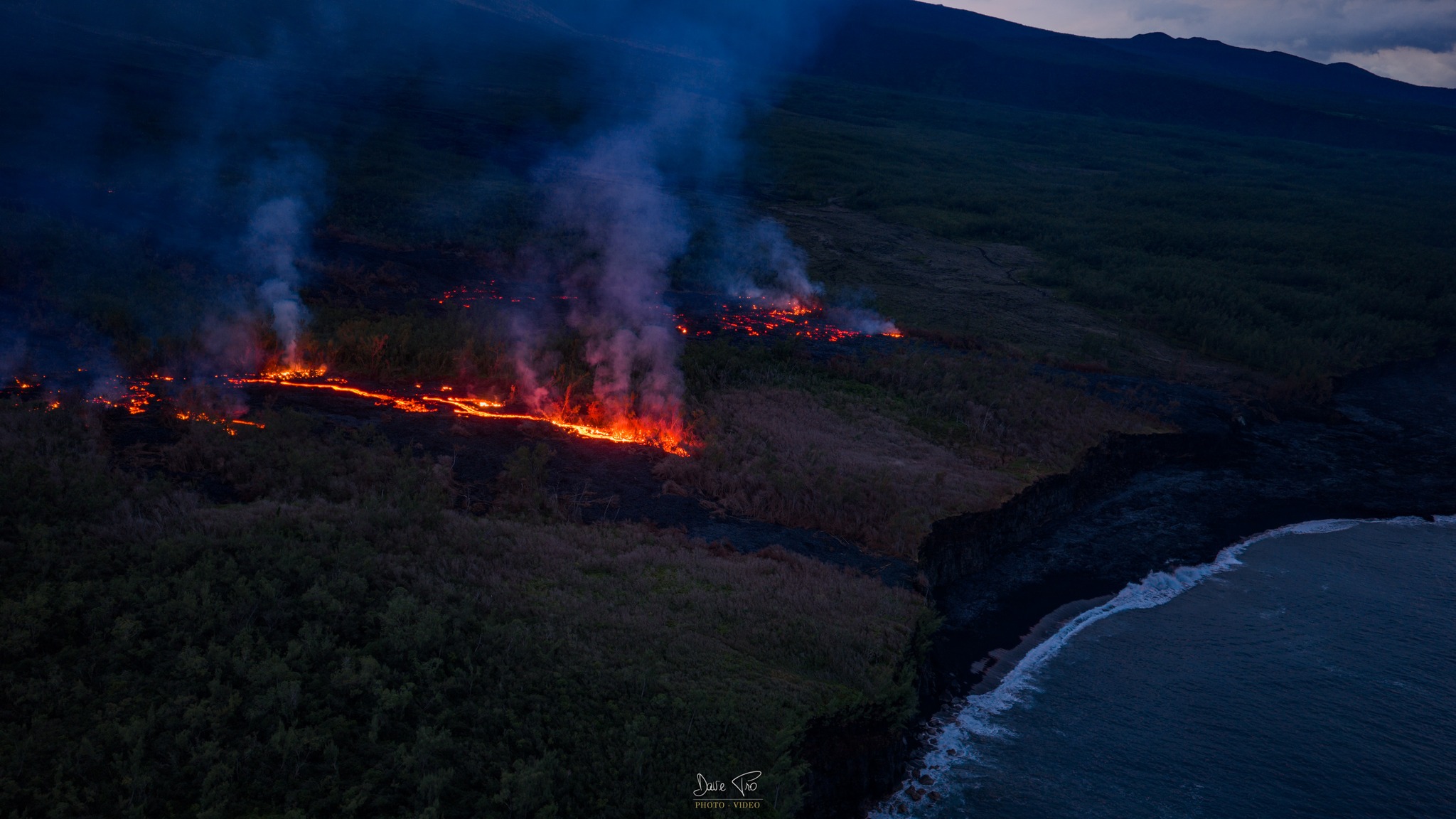
Last night, an incandescent point was again observed at the summit of the eruptive cone in the degassing zone. This incandescent point did not originate from lava ejecta. However, it is certain that very high-temperature material, potentially molten, still resides inside the cone. In the absence of in-situ analysis, several hypotheses can be considered: it could be a fracture resulting from a partial landslide at the summit of the recently formed cone, exposing this incandescent zone, or a small upwelling of material from the eruptive conduit. This incandescent point was no longer visible by the end of the night, on the morning of April 7.
It should be noted that in the past, phases of tremor without lava emission have already been observed at Piton de la Fournaise, although this remains rare, such as at the end of the September-October 2022 eruption, during which this phase lasted a little over 27 hours.
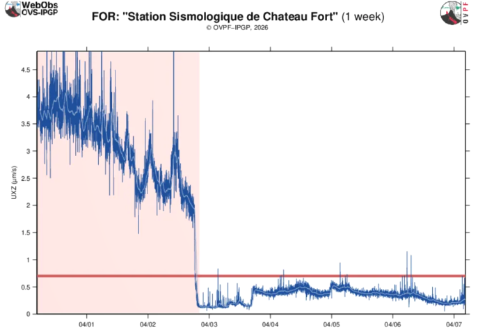
Amplitude of the eruptive tremor measured at the FOR seismic station located on the south-southeast flank of the volcano over the past week. The vertical axis indicates the tremor amplitude (in micrometers per second) and the X-axis represents the time in UTC (local time -4 hours). The eruptive period is indicated in red (©OVPF-IPGP).
Seismicity
Since the cessation of surface eruptive activity on April 3 at 00:10 (local time), seismicity beneath the summit has decreased. No volcano-tectonic earthquakes have been recorded in the last 24 hours.
Deformation
Concurrently, slight inflation of the summit area of the volcano has been recorded again, indicating a re-pressurization of the shallow magma reservoir.
*Volcanic tremor: a near-continuous seismic signal associated with the circulation of magmatic and/or gaseous fluids within the volcanic edifice. Its source mechanisms may include fluid flow, flow instabilities, and resonance of fluid-filled conduits or fractures.
Source : OVPF-IPGP.
Photos : Dave Pro , OVPF.
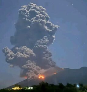
Indonesia , Dempo :
DEMPO VOLCANO ERUPTION, SOUTH SUMATRA, APRIL 7, 2026, 1:39 AM WIB
Dempo Volcano is an active stratovolcano located in the Lahat and Empat Lawang districts of South Sumatra province. Its elevation is 3,173 meters. Volcanic activity is currently concentrated in the Marapi crater.
On April 7, 2026, at 1:39 AM WIB, Dempo Volcano erupted. A thick, gray, eastward-dipping eruptive column was observed, reaching approximately 2,500 meters above the summit (approximately 5,673 meters above sea level). This eruption was recorded on a seismogram with a maximum amplitude of 30 mm and a duration of approximately 2 minutes and 56 seconds. Light ashfall was reported on the eastern slope, 4.7 km from the summit.

Seismic monitoring from March 23 to April 6, 2026, recorded one low-frequency (LF) earthquake, two deep volcanic earthquakes (SVP), one local tectonic earthquake (ST), 15 distant tectonic earthquakes (ST), and continuous tremors with amplitudes ranging from 0.5 to 1 mm, primarily 0.5 mm.
Observations of Mount Dempo’s deformation using the GNSS method, conducted from March 23 to April 6, 2026, revealed no significant changes. Concurrently, tiltmeter data from the Tugu Rimau station, since April 2, 2026, have shown an inflationary trend, indicating increased pressure at shallow depths.
The eruption of Mount Dempo is phreatic, meaning it can occur suddenly, without any apparent volcanic symptoms. Based on the analysis of visual and instrumental data, the activity level of Mount Dempo remains at level II (WASPADA). Residents, visitors, and tourists are advised to avoid approaching or spending the night at the center of activity, the Marapi crater, within a 1 km radius and within a 2 km radius around its northern opening, due to the risk of potentially lethal phreatic ejections and volcanic gases.
Source : PVMBG.
Photo : Mads N.
New Zealand , White Island :
No eruptive activity or ash emissions observed from Whakaari/White Island since 24 March. Volcanic Alert Level remains at 2 and Aviation Colour Code lowered to Yellow.
Published: Tue Apr 7 2026 3:30 PM
Observations from an overflight on 4 April showed a weak steam-only plume rising above the island. The Volcanic Alert Level remains at 2 and the Aviation Colour Code is lowered to Yellow.
In the last week, favourable weather has provided good views from our mainland cameras, allowing us to see a weak steam plume above Whakaari/White Island. This is consistent with observations from an observation flight on 4 April, where a vivid white plume rising from the active vent was seen. There was no evidence of any new ashfall on the island or ballistic blocks in the crater floor. Images captured using our thermal camera showed that maximum vent temperatures were about 100 ºC.
Image of the steam plume at Whakaari/White Island captured on our observation flight on 4 April.
The volcano is not currently erupting. However, volcanic activity can escalate with little or no warning. Future eruptions could affect the crater floor and immediate vicinity of the island, although ashfall affecting the mainland remains unlikely.
Given our current lack of real-time monitoring data from the island, we cannot distinguish between Volcanic Alert Level (VAL) 1 and 2. As a result, Whakaari/White Island will remain at minimum at VAL 2 until on-island monitoring is reinstated.
The Earth Sciences New Zealand Volcano Monitoring Group and National Geohazards Monitoring Centre continue to closely monitor Whakaari/White Island for any changes in activity. Without sensors on the island, our monitoring of Whakaari/White Island continues to rely on remote cameras, satellite imagery, and periodic gas and observation flights. We will provide further updates when information becomes available.
Source and photo : Geonet / Paul Jarvis / Duty Volcanologist
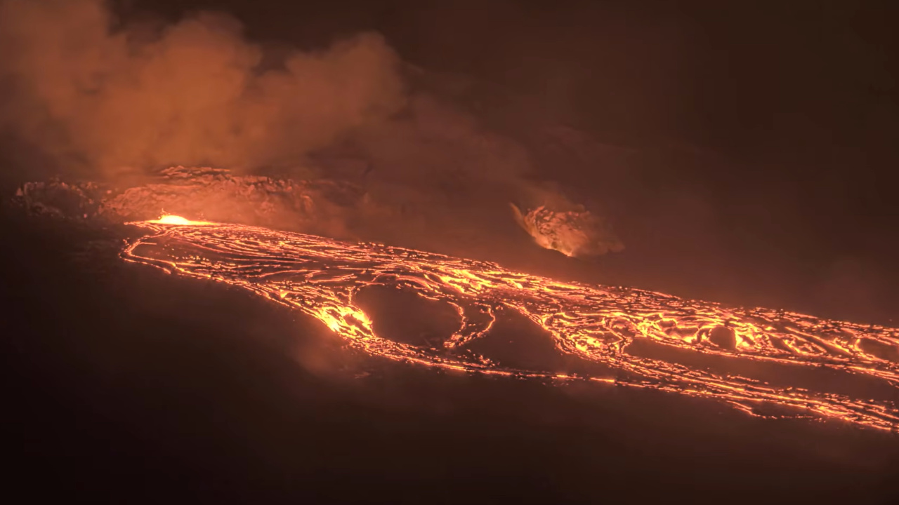
Guatemala , Fuego :
Atmospheric conditions: Clear skies
Wind: North
Rainfall: 7.9 mm
Activity
During the night and early morning, weak to moderate degassing was recorded, with fumaroles reaching approximately 300 meters above the crater and dispersing to the south and southwest. Explosive activity continued with 8 to 12 weak to moderate explosions per hour, generating ash plumes between 4,400 and 4,700 meters in altitude, which drifted to the south and southwest.
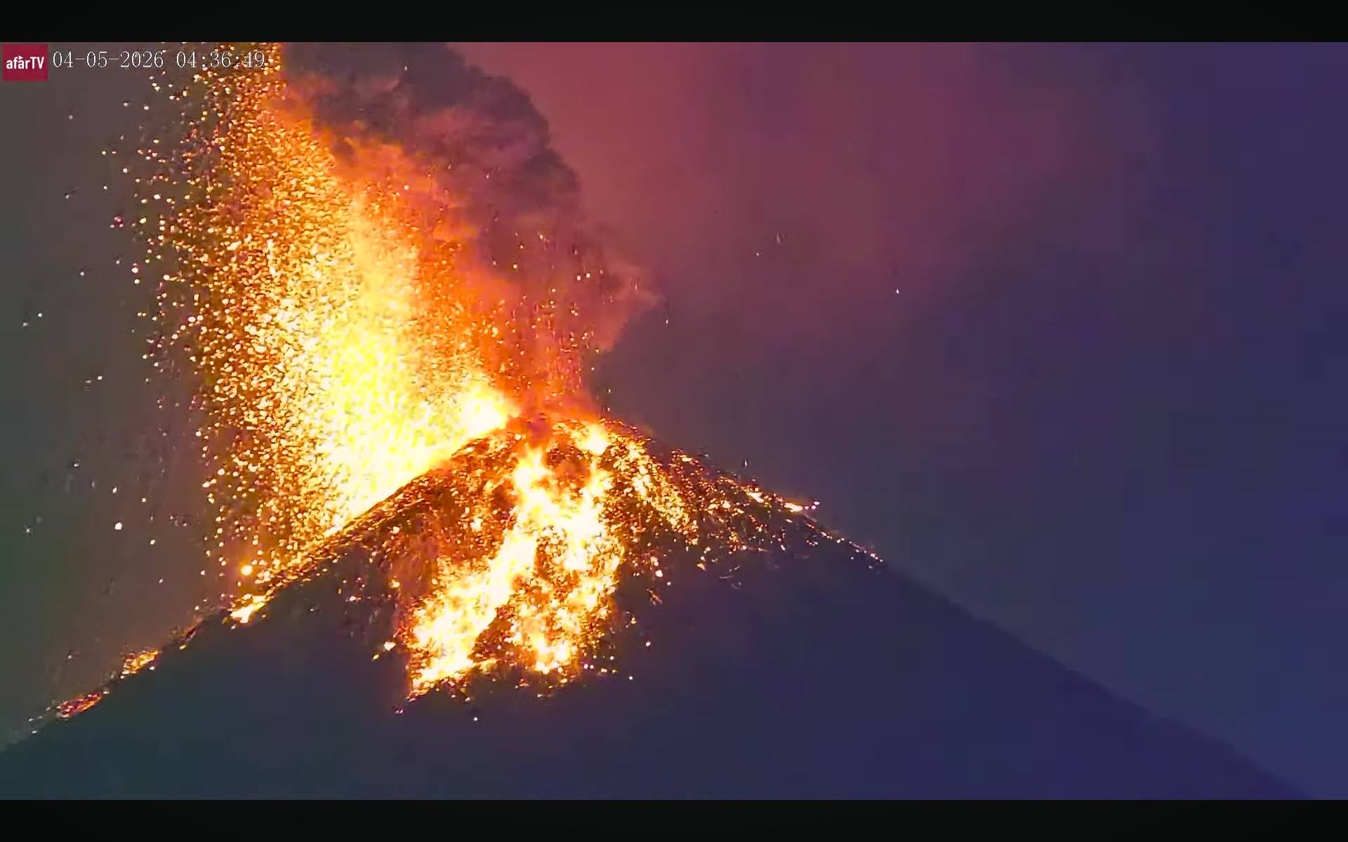
Some explosions were accompanied by rumbling sounds, shock waves, and brief noises similar to those of locomotives, associated with the continuous expulsion of gas. Incandescent pulsations were observed up to 200 meters above the crater, accompanied by small avalanches. In addition, incandescent material fell back around the crater, flowing into the ravines of Ceniza, Taniluyá, Seca, Santa Teresa, Trinidad, and Las Lajas, sometimes reaching the tree line.
Source : Insivumeh
Photo : Afar TV.