March 8 , 2026.
La Réunion Island , Piton de la Fournaise :
Press release from the Paris Institute of Earth Physics / Piton de la Fournaise Volcanological Observatory, March 8, 2026 – 9:30 a.m. local time – 5:30 a.m. UTC
Eruption in progress
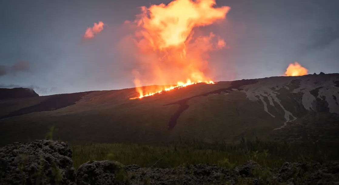
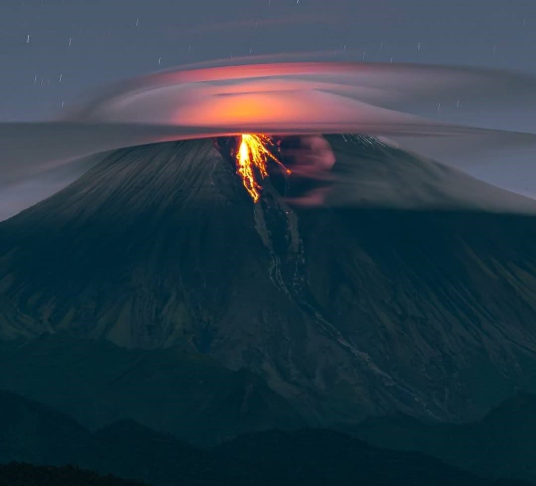
The eruption that began on February 13, 2026, shortly after 10:00 a.m. (local time) at Piton de la Fournaise continues.
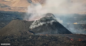
Only one eruptive site remains active on the south-southeast flank of the volcano, visible from Piton de Bert. The eruptive cone is now well-formed and continues to close progressively. Few ejecta now exceed the height of the cone.
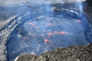
With the lateral closure of the cone, significant lava tube activity is now established. Since March 3, lava flows have again been visible in the upper part of the Grandes Pentes, with a new flow arm.
The front of the southern arm of the lava flow, currently visible from Grand Brulé, was located on the evening of March 7th approximately 3.7 km from National Route 2, at an altitude of 1070 m. The front is progressing slowly and has traveled about 300 m in a day and a half. At the bottom of Grandes Pentes, the front of the most downstream arm of the lava flow remains stationary at approximately 2.6 km from National Route 2, at an altitude of 660 m.
As in previous days, seismic activity remains low.
The resumption of inflation of the edifice, visible particularly on the summit GNSS stations and at the base of the terminal cone, is now well established. Indeed, since the end of February, the baselines crossing the summit have recorded an increase in distance, indicating a progressive re-expansion of the edifice.
This inflation indicates a repressurization of the magma supply system, possibly linked to magma recharge from the shallow reservoir.
Over the past 24 hours, eruptive tremor (an indicator of lava and gas emissions at the surface) has remained relatively stable. In the long term, the tremor amplitude has shown a gradual increase since February 21st. Some amplitude peaks are still being recorded, likely linked to variations in degassing or morphological changes in the eruptive cone.
Cloud cover over the past 24 hours has prevented reliable surface flow measurements via the HOTVOLC platform (OPGC – Clermont Auvergne University). Estimates of surface lava flow rates indicate that approximately 12 million m³ of lava were emitted to the surface between February 13 and March 6, 2026.
TROPOMI satellite data from March 7, 2026, highlight the sulfur dioxide (SO₂) plume extending south and west from Piton de la Fournaise, confirming the ongoing degassing associated with the eruption. Satellite estimates of the sulfur dioxide (SO₂) flux show a degassing peak at the start of the eruption on February 13, followed by a gradual decrease and lower but persistent values over the past few weeks, broadly consistent with measurements from the DOAS NOVAC network. The total mass of SO₂ emitted since the start of the eruption is estimated at over 30 kt.
Alert Level 2.1
Source : OVPF/IPGP.
Photo : Jeremix Sage / FB.
Indonesia , Lewotobi Laki-Laki :
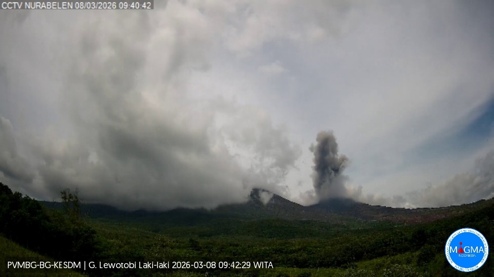
An eruption of Mount Lewotobi Laki-laki occurred on Sunday, March 8, 2026, at 9:37 AM WITA. The observed ash column rose approximately 1,000 meters above the summit (about 2,584 meters above sea level). This ash column was gray and denser, oriented to the north and northeast. The eruption was recorded by a seismograph with a maximum amplitude of 7.4 mm and a duration of 115 seconds.
VOLCANO OBSERVATORY NOTICE FOR AVIATION – VONA
Issued : March 8 , 2026 .
Volcano : Lewotobi Laki-laki (264180)
Current Aviation Colour Code : ORANGE
Previous Aviation Colour Code : orange
Source : Lewotobi Laki-laki Volcano Observatory
Notice Number : 2026LWK020
Volcano Location : S 08 deg 32 min 20 sec E 122 deg 46 min 06 sec
Area : East Nusa Tenggara, Indonesia
Summit Elevation : 5069 FT (1584 M)
Volcanic Activity Summary :
Eruption with volcanic ash cloud at 01h37 UTC (09h37 local).
Volcanic Cloud Height :
Best estimate of ash-cloud top is around 8269 FT (2584 M) above sea level or 3200 FT (1000 M) above summit. May be higher than what can be observed clearly. Source of height data: ground observer.
Other Volcanic Cloud Information :
Ash cloud moving from north to northeast. Volcanic ash is observed to be gray. The intensity of volcanic ash is observed to be thick.
Remarks :
Eruption recorded on seismogram with maximum amplitude 7.4 mm and maximum duration 115 second.
Source et photo : Magma Indonésie .
Colombia , Galeras :
San Juan de Pasto, March 3, 2026, 4:20 PM
Regarding the monitoring of activity at the Galeras volcano, the Colombian Geological Survey (SGC), an agency under the Ministry of Mines and Energy, reports the following:
For the period from February 24 to March 2, 2026, the main variations in monitored parameters compared to the previous week were as follows:
● Despite low volcanic activity, stability was observed in both seismic occurrence and energy release. The predominant seismicity associated with rock fracturing processes within the volcanic edifice remains.
● Most of the localized earthquakes occurred near the main crater, at distances of less than 2 km, at depths of less than 15 km from the summit of the Galeras volcano (4,200 m altitude), and with a magnitude of less than 1.0.

● During the week, low-altitude plumes of white gas were observed, with varying dispersion depending on wind direction, originating primarily from the fumarole fields of El Paisita to the north, Las Chavas to the west, and the main crater.
● Other volcanic monitoring parameters remained stable.
Given the above, the Colombian Geological Survey (SGC) recommends closely monitoring its evolution through weekly bulletins and other information published by its official channels, as well as instructions from local and departmental authorities and the National Unit for Disaster Risk Management (UNGRD).
Volcanic activity remains at the yellow alert level: Active volcano with changes in the baseline behavior of monitored parameters and other manifestations.
Source et photo : SGC.
Ecuador , Sangay :
DAILY REPORT ON THE STATE OF SANGAY VOLCANO, Saturday, March 7, 2026.
Geophysical Information Institute – EPN.
Surface Activity Level: High, Surface Trend: No Change
Internal Activity Level: Moderate, Internal Trend: No Change
Seismicity: From March 6, 2026, 11:00 AM to March 7, 2026, 11:00 AM:
Seismicity:
Explosions (EXP): 281
Precipitation/Lahars:
No precipitation has been recorded in the volcano area. **Heavy rainfall could remobilize accumulated material, generating mud and debris flows that would cascade down the volcano’s flanks and flow into nearby rivers.
Emissions/Ash Column:
Since yesterday afternoon, several gas and ash emissions have been recorded by the monitoring camera system. These emissions are drifting southwest and northwest at an altitude of less than 1,200 meters above the crater. In this regard, the Washington VAAC has issued two reports of ash clouds reaching altitudes of 900 meters, drifting west, southwest, and northeast.
Other Monitoring Parameters:
The MIROVA-MODIS satellite system recorded two thermal anomalies, and the MIROVA-VIIRS 750 satellite system recorded one within the last 24 hours.
Observations:
Overnight and early this morning, the camera network observed several episodes of incandescent material falling from the volcano’s flanks, reaching approximately 800 meters below the crater rim. At the time of writing, the volcano remains shrouded in clouds.
Alert level: Yellow
Source : IGEPN
Photo : JC Torres / FB.
Costa Rica , Poas :
Latitude: 10.20°N
Longitude: 84.23°W
Altitude: 2687 m
Current Activity Level: Alert
This week, the tremor amplitude remained relatively stable. The number of long-period events increased, and some of these exhibited significant amplitudes. A shallow, proximal volcano-tectonic event of low magnitude (1.3) was recorded. The geodetic network recorded significant uplift of the crater edifice. DOAS stations detected a sulfur dioxide (SO₂) flux of 159 ± 83 t/d, higher than the previous week’s (66 ± 21 t/d).
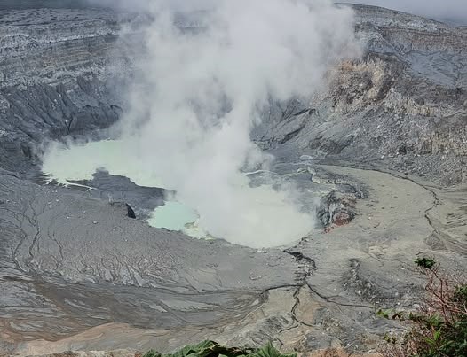
The level of the hyperacidic lake remained stable this week, with temperatures between 62 and 69 degrees Celsius, high surface evaporation, and a milky gray color. The lake’s chemical composition remains rich in chlorides relative to sulfates, as observed since September-October 2019, following the magmatic extrusion period of 2017. On March 3, using a Dräger MultiGAS portable instrument installed on the north-northwest rim of the crater, SO₂ concentrations in the ambient air were measured at between 10 and 19 parts per million, creating extremely acidic and corrosive conditions west of the crater. A mass of 3 tons of SO₂ was detected in the atmosphere by satellite on February 28.
Source : Ovsicori.
Photo : Sergio Lucena (archive).