April 21 , 2026.
La Réunion Island , Piton de la Fournaise :
Press release from the Paris Institute of Earth Physics / Piton de la Fournaise Volcanological Observatory, April 21, 2026 – 8:30 a.m. local time – 4:30 a.m. UTC
Tremor
Tremor* has been recorded since approximately 6:20 a.m. (local time, 2:20 a.m. UTC) on April 19. The intensity of this tremor is currently low and fluctuating.
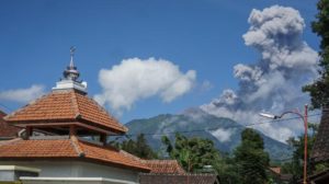
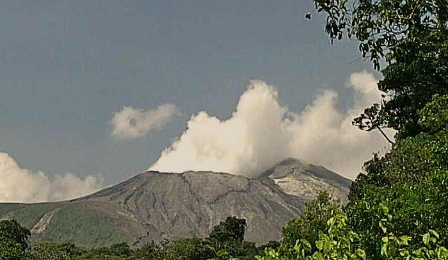
Currently, only degassing is observed at the eruptive sites associated with the activity from February 13 to April 12, located at an altitude of 2056-2120 m on the east-southeast flank of the volcano.
This tremor nevertheless indicates the presence of magma at shallow depths; therefore, a resumption of lava flows cannot be ruled out.

Seismicity
Since the cessation of surface eruptive activity on April 12 at 11:10 PM (local time), surface seismicity beneath the summit remains weak; however, deep seismicity persists. This seismicity is located west of the summit, approximately 6 km below sea level.
Deformation
In parallel, slight inflation continues to be recorded, primarily visible in the summit area and the terminal cone of the volcano. This parameter will be confirmed in the coming days.
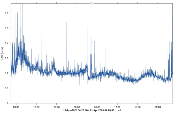
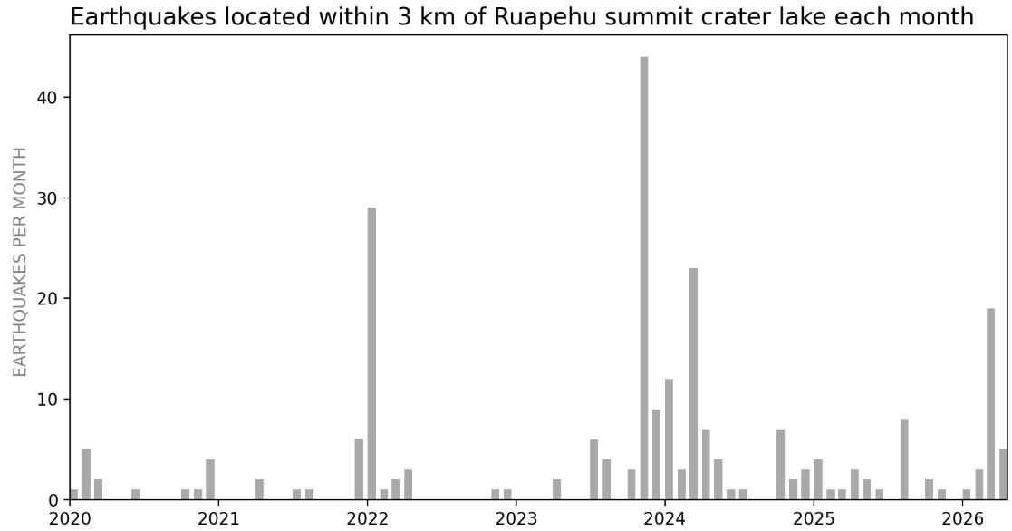
Amplitude of the eruptive tremor measured at the FOR seismic station located on the south-southeast flank of the volcano over the last 48 hours. The vertical axis indicates the tremor amplitude (in micrometers per second) and the X-axis represents the time in UTC (local time -4 hours) (©OVPF-IPGP).
*Volcanic tremor: a near-continuous seismic signal associated with the circulation of magmatic and/or gaseous fluids within the volcanic edifice. Its source mechanisms can include fluid flow, flow instabilities, and the resonance of fluid-filled conduits or fractures.
Source : OVPF-IPGP
Photos : Imaz Press Réunion , OVPF.
New Zealand , Ruapehu :
Update on Ruapehu: Lake temperature remains steady, small earthquakes under summit. Volcanic Alert Level remains Level 1
Published: Tue Apr 21 2026 11:00 AM
Since the last Ruapehu update in February, lake temperatures and gas emissions have remained stable. We have observed a small increase in seismic activity under the summit from mid-March to early-April. No noticeable change has been observed in Crater Lake composition. The Volcanic Alert Level at Ruapehu remains at Level 1 and the Aviation Colour Code at Green.
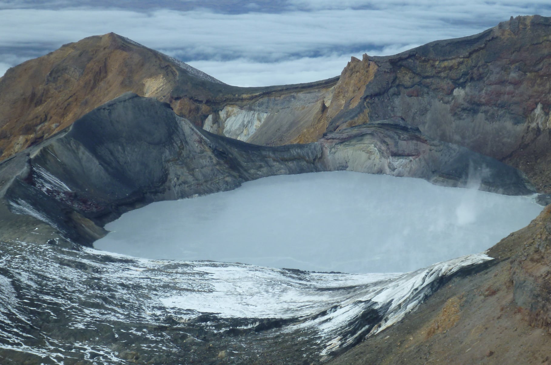
Our last update on observed volcanic activity at Ruapehu was in late February 2026. Since then, Te Wai ā-moe (Ruapehu Crater Lake) temperatures have remained relatively stable, fluctuating between 17 and 21°C. Gas output, measured by our sulphur dioxide scanners (more here) and airborne gas flights, has seen low to moderate emissions in line with long term trends.
Since mid-March, we have started to record a sequence of small earthquakes below the Crater Lake. As these are very small, we have only been able to locate 22 events, but many smaller, unlocatable events have been recorded by our seismographs within 2-3 km of the lake. Earthquakes below Crater Lake are not uncommon, with notable activity in January 2022, November 2023, and March 2024 (Figure 1). The current earthquake activity peaked between March 24 and 26 and has since declined. Earthquake activity in this area is persistent, but variable in rate. No other changes in seismic activity have occurred.
Plot of the number of earthquakes observed within 3km of the Ruapehu Crater Lake over the past six years, with notable increases in seismicity also occurring in in January 2022, November 2023, and March 2024.
A recent water and gas sampling of Crater Lake occurred in April, and multiple sulphur slicks were observed across the lake from upwellings in the northern vent area (underneath the lake), ranging from the more common yellow streaks to less-common dark grey. Sulphur slicks are commonly seen above the northern vent area. Analysis of the water and gases collected from the lake indicates that the chemistry is following trends established since 2022.
With the above information, we have decided to keep the Volcanic Alert Level at Level 1.
The Earth Sciences New Zealand Volcano Monitoring Group and National Geohazards Monitoring Centre will continue to closely monitor Ruapehu for any changes in activity. We will provide further updates when information becomes available or the status changes.
Source : Cam Asher / Duty Volcanologist / Geonet .
Photos : Geonet.
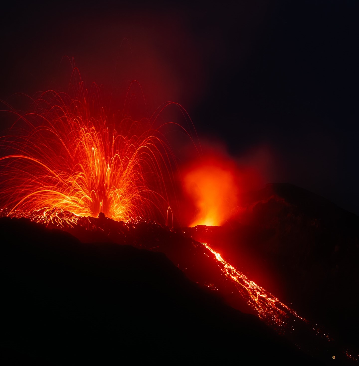
Italy , Stromboli :
Stromboli Activity Update, April 20, 2026, 10:03 (08:03 UTC).
The National Institute of Geophysics and Volcanology, Etna Observatory, announces that, based on analysis of surveillance camera images, the effusive activity linked to the lava flows described in the April 19, 2026, update has ceased.
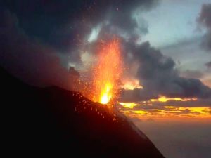
Lava ejection from the vents in the North Crater area continues.
From a seismic perspective, the average amplitude of volcanic tremors is currently within the normal range. No significant changes have been observed in the frequency and amplitude of explosion earthquakes.
GNSS network deformation data show no significant changes.
Further information will be released soon.
Source : INGV
Photo : Stromboli stati d’animo / Sebastiano Cannavo.
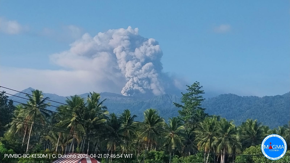
Indonesia , Dukono :
An eruption of Mount Dukono occurred on Tuesday, April 21, 2026, at 07:38 WIT, with an observed ash column height of approximately 1200 m above the summit (approximately 2287 m above sea level). This ash column, white to gray in color, was highly intense and directed towards the southeast. At the time of writing, the eruption was still ongoing.
Seismic Observations
132 eruption earthquakes with amplitudes ranging from 6 to 34 mm and durations from 29.8 to 97.23 seconds.
6 distant tectonic earthquakes with amplitudes ranging from 6 to 27 mm and durations from 61.35 to 96.5 seconds.
1 continuous seismic tremor with amplitudes ranging from 1 to 4 mm, primarily 2 mm.
Recommendations
(1) Communities living near Mount Dukono and visitors/tourists are advised to refrain from any activity, climbing, or approaching the Malupang Warirang crater within a 4 km radius.
(2) Since eruptions with volcanic ash occur periodically and the distribution of ash follows the direction and speed of the wind, making the ash cover area unstable, communities around Mount Dukono are advised to always have masks/face coverings and mouth coverings available to use as needed to avoid the dangers of volcanic ash to the respiratory system.
Source et photo : PVMBG
Costa Rica , Poas / Rincon de la Vieja :
Daily Volcanic Activity Bulletin. OVSICORI-UNA, Date: April 20, 2026. Updated at 11:57 AM
Volcano: Poás
Latitude: 10.200
Longitude: -84.233
Altitude: 2,687 m
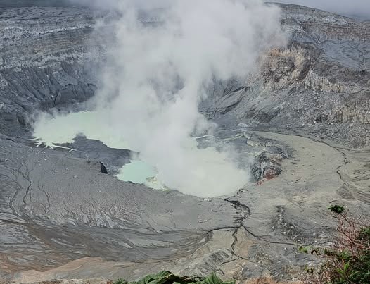
Observed Activity:
No eruptive activity has been recorded in the last 24 hours. Since yesterday, April 19, the intensity of background seismic tremor has increased slightly.
Long-period (LP) events continue to occur, although less frequently than yesterday.
The CO₂/SO₂ ratio shows some variability but remains within normal ranges. The H₂S/SO₂ ratio is stable.
Activity Level: Alert (2)
Volcano: Rincón de la Vieja
Latitude: 10.83
Longitude: -85.324
Altitude: 1,916 m
Observed Activity:
Yesterday, April 19, at 11:18 PM, an eruption was detected by seismic and acoustic recordings. This eruption had a seismic magnitude of 3.7 and an acoustic magnitude of 3.2. It could not be filmed because it occurred at night.
Brief aftershocks continue to be observed, but they are weak and infrequent. Background seismic tremor remains low.
Activity Level: Alert (2)
April 17, 2026 Time: 12:06 PM
Plume Height (above the crater): 2,000 m
Observed Activity:
A short-lived eruption was recorded, ejecting ash 500 m above the crater and a plume of steam, water, and magmatic gases up to 2,000 m above the crater. The plume drifted westward.
Source : Ovsicori.
Photos : Sergio Lucena , Ovsicori .