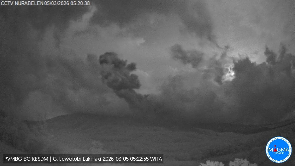
March 6 , 2026.
Indonesia , Lewotobi Laki-laki :
An eruption of Mount Lewotobi Laki-laki occurred on Thursday, March 5, 2026, at 4:45 PM WITA. The observed ash column rose approximately 1,200 meters above the summit (approximately 2,784 meters above sea level). This gray ash column was highly intense and directed northeast and east. The eruption was recorded by a seismograph, with a maximum amplitude of 14.8 mm and a duration of 97 seconds.
VOLCANO OBSERVATORY NOTICE FOR AVIATION – VONA
Issued : March 5 , 2026
Volcano : Lewotobi Laki-laki (264180)
Current Aviation Colour Code : ORANGE
Previous Aviation Colour Code : orange
Source : Lewotobi Laki-laki Volcano Observatory
Notice Number : 2026LWK019
Volcano Location : S 08 deg 32 min 20 sec E 122 deg 46 min 06 sec
Area : East Nusa Tenggara, Indonesia
Summit Elevation : 5069 FT (1584 M)
Volcanic Activity Summary :
Eruption with volcanic ash cloud at 08h45 UTC (16h45 local).
Volcanic Cloud Height :
Best estimate of ash-cloud top is around 8909 FT (2784 M) above sea level or 3840 FT (1200 M) above summit. May be higher than what can be observed clearly. Source of height data: ground observer.
Other Volcanic Cloud Information :
Ash cloud moving from northeast to east. Volcanic ash is observed to be gray. The intensity of volcanic ash is observed to be thick.
Remarks :
Eruption recorded on seismogram with maximum amplitude 14.8 mm and maximum duration 97 second.
Source et photo : Magma Indonésie.
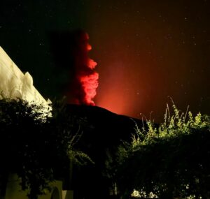
La Réunion Island , Piton de la Fournaise :
Press release from the Paris Institute of Earth Physics / Piton de la Fournaise Volcanological Observatory, March 6, 2026 – 8:35 a.m. local time – 4:35 a.m. UTC
Eruption in progress
The eruption that began on February 13, 2026, shortly after 10:00 a.m. (local time) at Piton de la Fournaise continues.
Only one eruptive site remains active on the south-southeast flank of the volcano, visible from Piton de Bert. The eruptive cone is now well-formed and continues to close progressively. Few ejecta now exceed the height of the cone.
With the lateral closure of the cone, significant lava tube activity is now established. Since March 3, lava flows have again been visible in the upper part of the Grandes Pentes. The lava flows develop both as cratons (a’ā lava) and as pāhoehoe (ropy lava) at the exit of active tunnels.
In the Grandes Pentes area, the front of the furthest downstream flow remains stationary approximately 2.6 km from National Route 2 and at an altitude of 660 m.
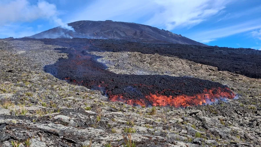
The lava field from the Piton de la Fournaise eruption of February 13, 2026, is expanding.
As in previous days, seismic activity remains low.
The resumption of inflation of the volcano, visible particularly on the summit GNSS stations and at the base of the terminal cone, is now well established. Since the end of February, the baselines crossing the summit have been showing an increase in distance, indicating a progressive re-expansion of the volcano.
This inflation indicates a repressurization of the magma supply system, possibly linked to magma recharge from the shallow reservoir.
Over the past 24 hours, eruptive tremor (an indicator of lava and gas emissions at the surface) has remained relatively stable. In the long term, the amplitude of the tremor shows a progressive increase since February 21. Some peaks in amplitude are still being recorded, probably linked to variations in degassing or morphological changes in the eruptive cone.
Surface flow rates, estimated from satellite data via the HOTVOLC platform (OPGC – Clermont Auvergne University), have indicated values between 1 and 10 m³/s over the past 24 hours. It should be noted that these estimates can vary significantly depending on cloud cover and become zero in the event of total cloud cover.
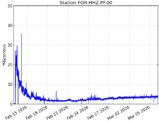
Evolution of tremor amplitude (an indicator of lava and gas emissions at the surface) between March 13 and 6, 2026, at the FOR seismological station located near the eruption (©WebObs/OVPF-IPGP).
Summary
Since the end of February, GNSS network data suggests inflation of the edifice. This development is thought to be linked to a repressurization of the magma supply system, possibly associated with a new phase of magma recharge in the shallowest reservoir.
Given the current low seismic activity, the probability of new eruptive fissures opening remains low in the short term.
Nevertheless, the first signs of possible repressurization could lead to an increase in this probability.
It should also be noted that in the past, eruptive fissures have opened during eruptions without any warning signs, such as in August 1998, July 1999, October 1999, December 2006, and March 2019. Indeed, the propagation of magma at shallow depths can occur aseismically, particularly when the magma has already degassed.
Alert Level 2.1
Source : OVPF/IPGP.
Photos : OVPF/IPGP.
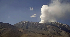
Chile , Lascar :
During the study period, a significant increase in volcano-tectonic (VT) seismic activity was recorded, associated with rock fracturing within the volcano. In particular, a swarm of VT events began on February 27 (reported in the electronic seismic bulletin for that date) and ended on March 2, totaling 965 earthquakes. The most energetic event had a local magnitude (Ml) of 2.2 and was located 4.4 km south-southwest (SSW) of the volcanic edifice, at a depth of 8.4 km. Long-period (LP) events, associated with fluid dynamics within the volcano, exhibited similar values in terms of quantity and energy compared to the previous month. The reduced displacement (DR) value of the most energetic event was 7.0 cm². In addition, 12 tremor-type (TR) seismic events were also recorded, associated with sustained fluid dynamics, with a maximum displacement radius (DR) of 10.0 cm². Furthermore, after the end of the VT seismic swarm, starting on March 3, episodes of low-pressure (LP) events, characterized by high recurrence and similar amplitude, were recorded and described as « drum-shaped » seismic signals. The occurrence of a hybrid seismic event (HB), associated with both rock fracturing and fluid dynamics, should be noted. Its local magnitude was 1.1 and its reduced displacement was 4 cm².

When weather conditions permitted, continuous whitish plumes of degassing were recorded rising from the active crater, reaching a maximum height of 1,340 m above the crater rim on February 9. Activity on February 8 (reported in REAV) and 27 was also notable, with increases in the density of the gas plumes, although no pyroclastic material was identified. Fourteen sulfur dioxide (SO₂) anomalies were detected in the atmosphere, according to data from the German Aerospace Center’s (DLR) Earth Observation Center (EOC), with a peak emission of 571 tonnes on February 8, consistent with the previously mentioned increase in surface activity.
Analysis of data from long- and short-period radar interferometry (InSAR) acquired from Sentinel-1 images revealed no deformation near the volcano. A significant change was identified inside the crater after February 8 using Sentinel-2 L2A images. This change is characterized by the appearance of areas of anomalous thermal radiation covering an area of approximately 3,600 m², according to data obtained via the NHI Tools web application. An increase in the frequency and intensity of thermal anomalies was also recorded by the MODIS sensor on the MIROVA platform, with a maximum radiative power of 4 MW on February 13. Using satellite imagery (Planetscope, Sentinel-2, SkySat Collect), degassing points were identified, but without significant morphological variations.
Source : Segemar.
Photos : terremotos y desastres ( archive) , Segemar.
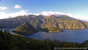
Colombia , Puracé – Puracé – Los Coconucos volcanic chain :
Popayán, March 3, 2026, 3:00 PM
Regarding the monitoring of activity at the Puracé volcano – Los Coconucos volcanic chain – the Colombian Geological Survey (SGC), an agency under the Ministry of Mines and Energy, reports the following:
During the week of February 24 to March 2, 2026, a predominance of earthquakes associated with fluid movements within the volcanic edifice, of the Long Period (LP) and Tremor (TR) type, persisted. These earthquakes, located below the crater of the Puracé volcano, at a depth of less than 1 km, were linked to processes of circulation and release of volcanic gases into the atmosphere. These gases dispersed with the wind, reaching a maximum altitude of 780 m above the summit of the volcano.

Fracture seismicity remained stable compared to previous weeks, both in terms of the number of events and the seismic energy released. It was primarily located between the Puracé and Piocollo volcanoes, at depths of 1 to 3 km. Sulfur dioxide (SO₂) emissions continued, and fumaroles persisted through the fissures of the Curiquinga and Piocollo volcanoes’ craters. No ash emissions were observed during this period. Satellite observations indicate that the energy of the thermal anomaly in the Puracé volcano crater persists. Furthermore, the slow deformation process continues between the Puracé, Piocollo, and Curiquinga volcanoes, as demonstrated by the eruptive episode of Curiquinga on January 20, 2025.
In conclusion, the observed variations at the Puracé volcano and the Los Coconucos volcanic chain indicate that the system continues to evolve and that ash emissions and fallout could continue, depending on the prevailing wind direction. The public is advised to refrain from ascending to the upper reaches of the volcanic chain and to remain attentive to official bulletins from the Colombian Geological Survey (SGC).
The alert level for volcanic activity remains yellow: active volcano exhibiting changes in monitored parameters and other manifestations.
Source et photo : SGC.
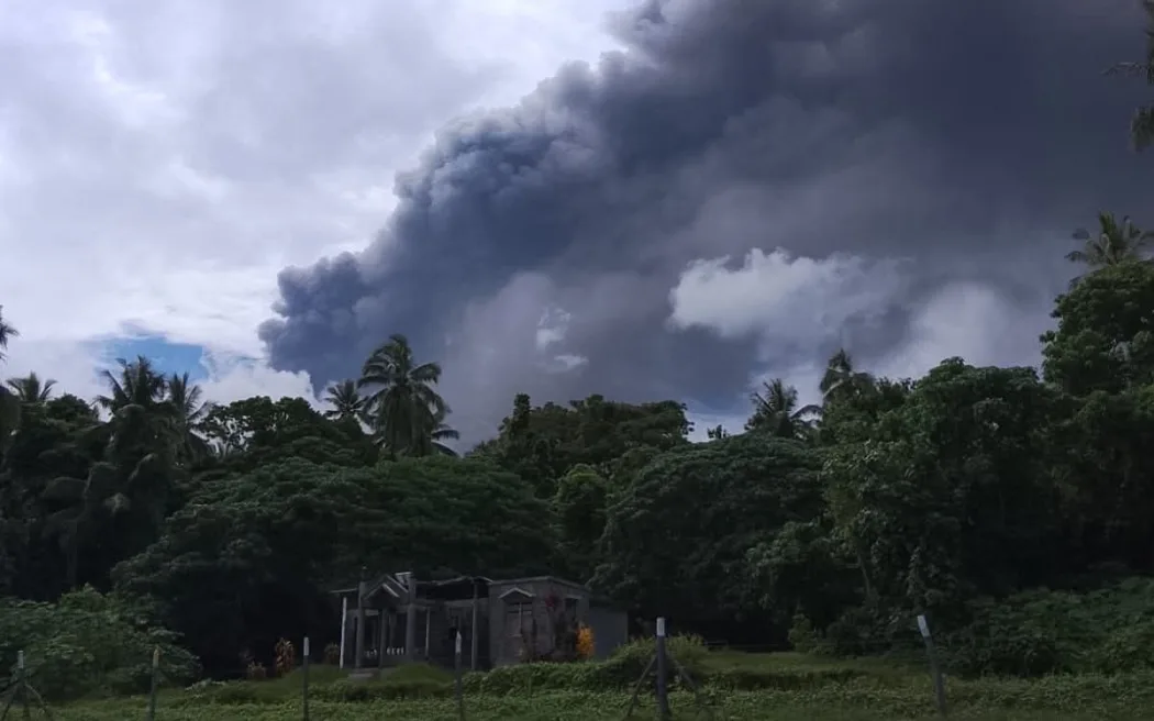
Vanuatu Archipelago , Ambae :
Vanuatu’s cabinet is convening an emergency meeting Friday to discuss escalating volcanic activity on Ambae Island.
Prime Minister Jotham Napat said that activity at Manaro volcano is increasing, and Penama province is preparing evacuation plans for a possible eruption.
The volcano is at alert level 3, with an ongoing minor eruption, and sending out emissions of ash and sulphur dioxide.
There is a no-go zone in a three-kilomtere radius of the volcano’s crater.
The National Disaster Management Office is monitoring activity, and authorities are urging residents to be ready to evacuate.
The Council of Ministers (COM) has approved 20 million Vatu budget support to the Penama provincial government to do necessary assessment work in the Ambae island volcanic disasters.
COM has acknowledged the Volcanic activities on Ambae island as a disaster that needs immediate monitoring on its impacts.
The Volcanic alert remains at level 3 for the Ambae Volcano.
Sources : RNZ.
Photo: Facebook / Ministry of the Prime Minister – Vanuatu