May 9 , 2026.
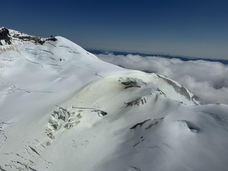
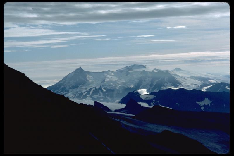
Alaska , Kupreanof :
ALASKA VOLCANO OBSERVATORY INFORMATION STATEMENT , U.S. Geological Survey
Friday, May 8, 2026, 11:46 AM AKDT (Friday, May 8, 2026, 19:46 UTC)
56°45″ N 159°47’28 » W,
Summit Elevation 6217 ft (1895 m)
Current Volcano Alert Level: UNASSIGNED
Current Aviation Color Code: UNASSIGNED
Increased seismic activity and gas emissions at Kupreanof Volcano.
Overview
Seismic activity and sulfur dioxide (SO2) emissions from Kupreanof Volcano have increased over the last few months.
The cause of these increases is likely magmatic intrusion beneath Kupreanof Volcano.
Data do not suggest an eruption is imminent and further signs of increased unrest would be expected prior to eruption
Earthquake Activity
An increase in seismicity beneath Kupreanof Volcano began in February 2026. Multiple pulses of deep (>12 miles or 20 km) low-frequency earthquakes occurred in early February and early March. Shallow earthquake activity increased in early April, including several events with magnitudes greater than 2. The largest events to date occurred on April 12 and 22 and each had a magnitude of 3.1. Seismicity during the second half of April and early May has consisted of intermittent shallow earthquakes, mostly less than magnitude 2.5, along with occasional deep low-frequency events.
AVO does not maintain a local monitoring network at Kupreanof Volcano, and seismicity is therefore detected using regional stations. The closest functioning seismometer is currently located 17 miles (27 km) to the east at Veniaminof Volcano. The lack of a local monitoring network and the limited number of regional stations mean that smaller events (magnitudes less than 2) are often not detected or located, and earthquake locations have relatively large uncertainties.
Gas Emissions
Since April 4, sulfur dioxide (SO2) emissions from Kupreanof Volcano have been seen in satellite data on 8 occasions with emission rates of ~100 to 1,000 tons per day. While Kupreanof Volcano is known to have persistent gas emissions from a fumarole field active just west of the summit, SO2 emissions from Kupreanof Volcano have not been seen previously in satellite data. Airborne gas surveys conducted by helicopter in 2019 and 2022 measured less than 100 tons per day. While some volcanic gases can originate from crustal sources such as carbonate rocks or hydrothermal systems, SO2 is almost always associated with direct degassing from magma. Collectively these observations suggest an increase to above background levels in volcanic gas emissions, likely due to intrusion of new magma beneath Kupreanof Volcano.
Interpretations and Hazards
The earthquake types and locations, along with the observed SO2, suggest magma has likely intruded at depth beneath Kupreanof Volcano and has migrated to shallower levels (<3 miles or 5 km), activating a fumarole field at about 5,000 ft elevation west of the summit. Because of this, if eruptive activity does occur, it may be either hydrothermal or magmatic. Intrusions of new magma under volcanoes do not always result in volcanic eruptions. The earthquake activity and gas emissions at Kupreanof Volcano may cease with no eruption occurring. If the magma rises closer to the surface, this will likely lead to increased unrest, such as a change in the rate and style of earthquake activity, surface heating, and increased gas emissions. Therefore, it is very likely that if an eruption were to occur it would be preceded by additional signals that would allow advance warning.
Background
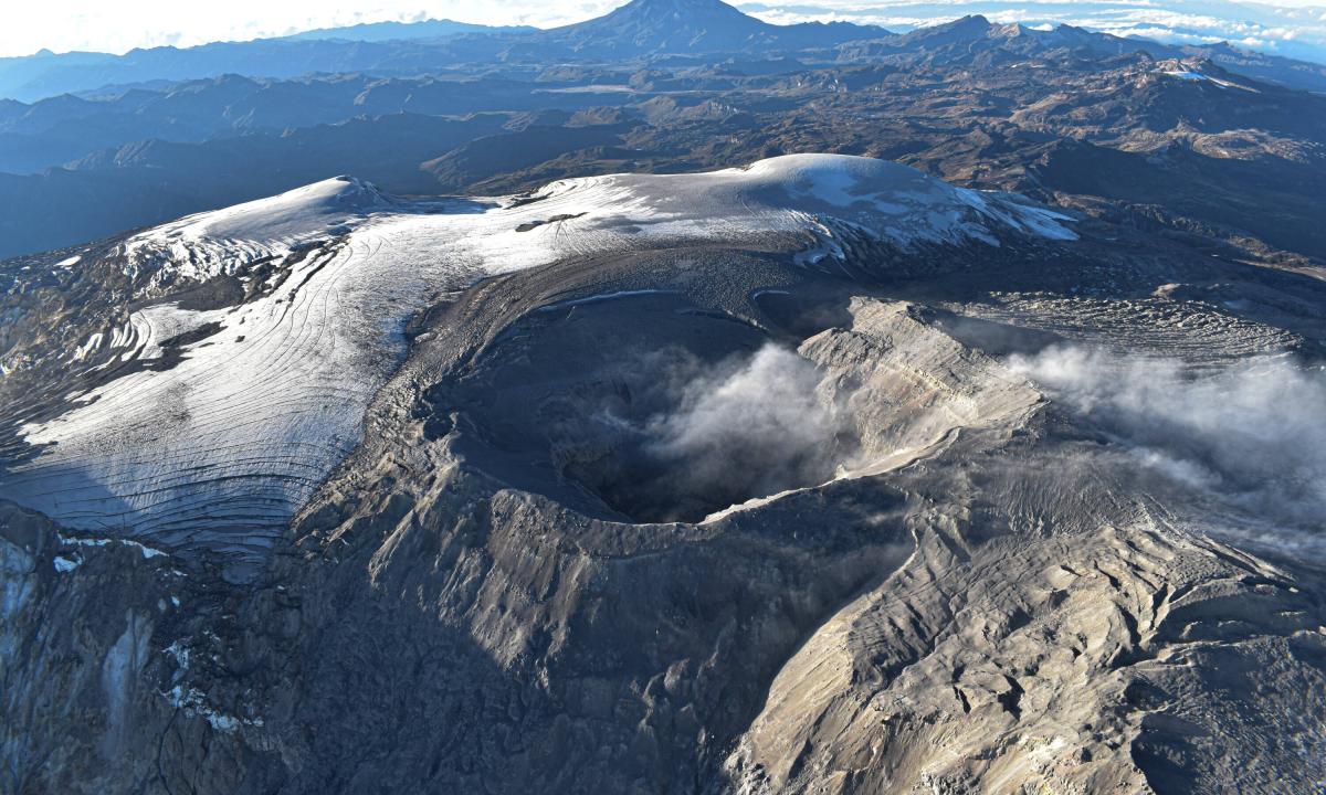
Mount Kupreanof is a heavily glaciated stratovolcano on the Alaska Peninsula with no known historical eruptions. Very little is known about its eruptive history. A single debris flow or block-and-ash flow deposit has been mapped in a valley south of the volcano with a suspected Holocene age. Eruptions will likely produce lahars and pyroclastic flows on the volcano’s flanks and into the surrounding uninhabited valleys. Ash plumes could affect communities and airplanes downwind of the volcano. A vigorous fumarole field just west of the summit produces persistent steam plumes.
There is no real-time geophysical monitoring network at Mount Kupreanof. The closest seismometers are approximately 10 miles (16 km) to the east of the volcano as part of the Veniaminof network. Mount Kupreanof is also monitored by satellite data, remote infrasound and lightning networks, and visual observations from pilots and mariners passing by the volcano.
Source : AVO.
Photos : Boyce, Ellie / Alaska Volcano Observatory / University of Alaska Fairbanks, Geophysical Institute , Miller, Thomas , AVO/USGS.
Indonesia , Dukono :
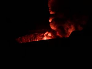
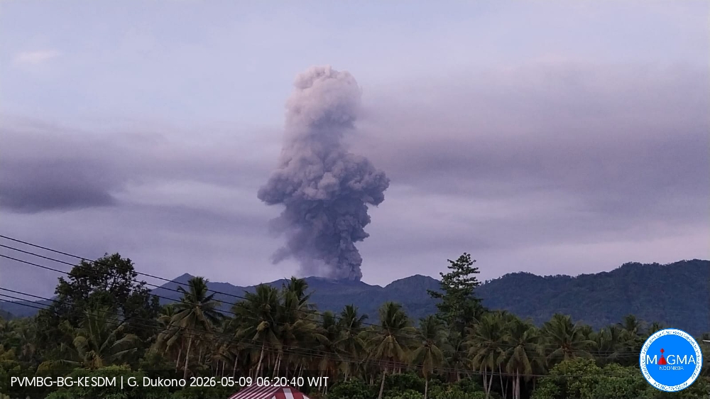
An eruption of Mount Dukono occurred on Saturday, May 9, 2026, at 06:10 WIT, with an observed ash column height of approximately 3,000 m above the summit (approximately 4,087 m above sea level). This ash column, white to gray in color, was highly intense and directed northward. The eruption was recorded by a seismograph with a maximum amplitude of 34 mm and a duration of 70.72 seconds.
Seismic Observations
126 eruption earthquakes with amplitudes between 3 and 34 mm and durations from 29.6 to 967.56 seconds.
4 harmonic tremors with amplitudes between 15 and 22 mm and durations from 87.34 to 177.89 seconds.
2 distant tectonic earthquakes with amplitudes between 6 and 20 mm and durations from 57.16 to 101.4 seconds.
1 continuous tremor earthquake with amplitudes between 1 and 3 mm, primarily 1 mm.
Recommendations
(1) Residents living near Mount Dukono and visitors/tourists are advised to refrain from any activity, climbing, or approaching the Malupang Warirang crater within a 4 km radius.
(2) Considering that eruptions with volcanic ash occur periodically and that the distribution of ash follows the direction and speed of the wind, so that the area where the ash lands is not constant, people living around Mount Dukono are advised to always carry masks/face coverings and mouth coverings to use when needed to avoid the threat that volcanic ash poses to the respiratory system.
Source et photo : PVMBG.
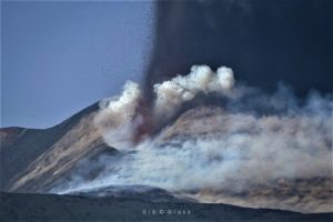
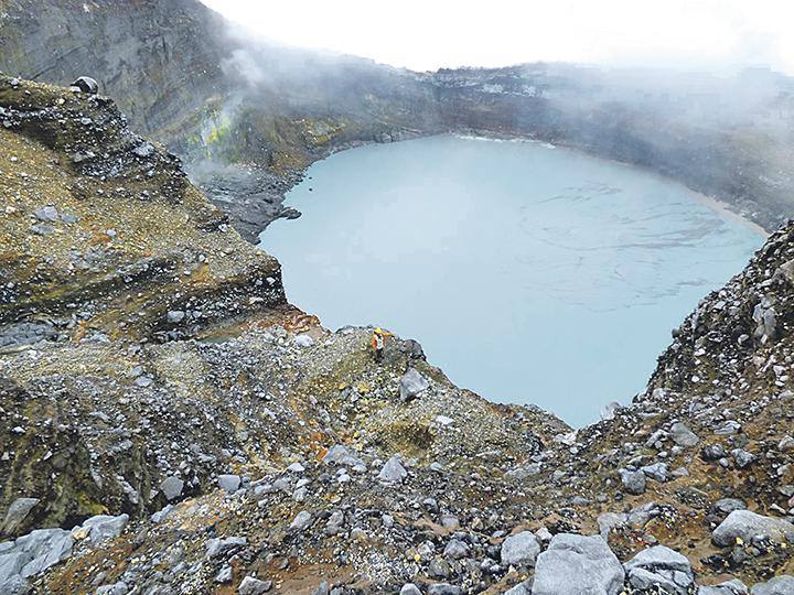
Colombia , Nevado del Ruiz :
Manizales, May 5, 2026, 4:45 PM
Regarding the monitoring of activity at the Nevado del Ruiz volcano, the Colombian Geological Survey (SGC), an agency under the Ministry of Mines and Energy, reports the following:
During the week of April 28 to May 4, 2026, the volcano continued to exhibit unstable behavior. Compared to the previous week, the main variations in monitored parameters were as follows:
– Seismic activity associated with rock fracturing processes within the volcanic edifice increased slightly, both in the number of recorded earthquakes and in the seismic energy released. The earthquakes were primarily located in the Arenas crater and on the west, southwest, and northeast flanks of the volcano, within 5 km of the crater. Smaller and more scattered earthquakes were recorded in other areas, up to 10 km from the crater. In general, the depth of the events varied between less than 1 km and 6 km below the reference level. The maximum recorded magnitude was 2.5, corresponding to the earthquake that occurred on May 3 at 6:34 a.m., 5 km west of the Arenas crater and at a depth of 4 km.
– Seismicity associated with fluid dynamics in volcanic conduits remained at similar levels in terms of the number of recorded earthquakes and seismic energy released. These seismic signals corresponded to short-duration, low-energy events. No long-duration events were recorded during this week, and no pulsatile ash emissions or changes in the apparent temperature of the gas column, associated with this type of seismic signal, were confirmed.
– The volcano continued to emit water vapor and volcanic gases, primarily sulfur dioxide (SO₂), into the atmosphere from the Arenas crater. The estimated SO₂ flux associated with degassing processes remained variable and low, increasing compared to the previous week. This increase is partly attributed to the direction of prevailing winds, which shifted toward the northwest flank of the volcano, where monitoring station coverage is greater. Further satellite monitoring confirmed low levels of SO₂ emissions.
– The height of the gas and water vapor plume remained primarily between 300 and 400 m above the volcano’s summit, and occasionally between 700 and 1,000 m. The latter height was observed on the evening of April 28. The ash plume’s dispersion direction was variable, with a preference for the northwest flank and, to a lesser extent, the north-northwest and west-northwest flanks of the volcano.
Monitoring of thermal anomalies at the bottom of the Arenas crater, using satellite imagery, showed that the energy levels of these anomalies remained low.
Source et photo : SGC.
Costa Rica , Rincon de la Vieja :
Latitude: 10.83°N;
Longitude: 85.34°W;
Altitude: 1916 m
Current Activity Level: Alert.
Only one eruption was recorded this week, on May 7 at 00:52. This eruption showed a slight increase in acoustic amplitude compared to the previous week and is the most energetic of the year so far. However, it did not generate any lahars. The background tremor remains of variable amplitude and exhibits high frequencies (2.5 and 6 Hz). The overall trend is downward. Short tremors of varying amplitude and duration were also recorded, with a lower frequency content (1-3 Hz) than the background tremor. An increase in the number of long-period events and low-frequency tremor (1.5 Hz) was observed prior to the May 7 eruption. The occurrence of « tornillo » type events of stable amplitude continues.
The dominant frequency of tornillo events continues to decrease this week. Seven volcano-tectonic earthquakes distal to the crater were recorded this week.
The geodetic network is not detecting any significant deformation.
The last detection of SO₂ in the atmosphere by the SENTINEL satellite, emitted by the Rincón de la Vieja volcano, dates back to September 7, 2025.
Source et photo : Ovsicori.
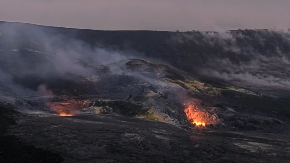
Hawaii , Kilauea :
HAWAIIAN VOLCANO OBSERVATORY DAILY UPDATE , U.S. Geological Survey
Friday, May 8, 2026, 8:50 AM HST (Friday, May 8, 2026, 18:50 UTC)
19°25’16 » N 155°17’13 » W,
Summit Elevation 4091 ft (1247 m)
Current Volcano Alert Level: ADVISORY
Current Aviation Color Code: YELLOW
Summary:
The eruption at the summit of Kīlauea is currently paused. The preliminary forecast window for episode 47 is May 12 – May 17, 2026.
Overview:
Episode 46 of lava fountaining in Halemaʻumaʻu at the summit of Kīlauea occurred on May 5. The eruption is currently paused. The preliminary forecast window for episode 47, based on tilt data, suggests that lava fountaining will occur again sometime between Tuesday, May 12 and Sunday, May 17. This window may be adjusted based on continuing observations.
No significant activity has been noted along Kīlauea’s East Rift Zone or Southwest Rift Zone.
Summit Observations:
Consistent glow from the south vent with occasional flames and intermittent glow from the north vent were observed on webcams overnight. Points of incandescence remain in the crater floor lava flow field emplaced during episode 46, though they are diminishing.
Seismic tremor continues during the current pause, with bursts of tremor every 1–10 minutes that are typical after the end of fountaining and are likely associated with gas pistoning cycles in the eruptive vents. Over the past day, the tremor bursts have become longer with more gradual onsets. Earthquake activity at the summit during and after episode 46 has been low, with 1 small earthquake recorded in the past day.
The Uēkahuna tiltmeter (UWD) recorded about 14.0 microradians of deflationary tilt during episode 46. Since the end episode 46, summit inflation has resumed, with the same tiltmeter recording about 6.9 microradians of inflationary tilt as of this morning.
With the eruption now paused, the SO2 emission rate is likely now varying within a typical range of 1,000 to 5,000 tonnes per day.
Rift Zone Observations:
Rates of seismicity and ground deformation remain low in the East Rift Zone and Southwest Rift Zone. SO2 emissions from the East Rift Zone remain below the detection limit.
Source et photo : AVO