May 10 , 2026.
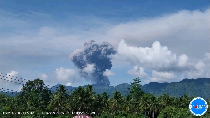
Indonesia , Dukono :
Three people hiking on Indonesia’s Mount Dukono have died after the volcano erupted on Friday morning.
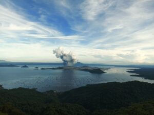
Videos and pictures of the eruption show the volcano, located on North Maluku island, spewing a column of ash stretching 10km (six miles) into the sky.
The three victims were part of a group of 20 Singaporeans and Indonesians hiking on the mountain despite restrictions. The rest of the group was eventually located by rescuers and evacuated from the mountain.
The volcano has erupted more than 200 times since last March. Officials had previously issued warnings against climbing the mountain due to safety concerns.
The latest eruption took place at 07:41 local time (22:41 GMT Thursday), when there were several people on the mountain on early morning hikes.
Indonesian officials said two Singaporeans and one local resident from the nearby city of Ternate had died. Both of the foreign victims are believed to be male, with one aged 30 and the other 27. The local victim is said to be a female, but no more details were given.
The bodies of the three deceased are still on the mountain, according to North Halmahera police chief Erlichson Pasaribu – though most of the hiking group have been safely evacuated and sent to hospital.
Two members of the group, who are porters, stayed behind on the mountain to help rescue workers locate the bodies.
On Friday afternoon, Mount Dukono was still emitting volcanic material from its crater, according to one local resident assisting rescuers.
Aldy Salabia told BBC Indonesian that they were at a local shelter on the mountain preparing for the rescue operation.
« From the shelter, we can see ash and rock material continuously being ejected, » he said.
Erlichson said that retrieval of the bodies had been hampered by repeated eruptions, difficult terrain and strong blasts from the volcano.
The operation to reach the volcano’s crater – where the bodies of the victims are though to be located – was paused as night fell on Friday evening, with Erlichson saying it would resume on Saturday.
Besides the 20-member hiking group, eyewitness accounts indicate there were other hikers on the mountain as well.
One guide who was on Mount Dukono with two clients at the time of the eruption told BBC Indonesian that he believed high pressure had been building up inside the volcano for several days.
« When Dukono hasn’t erupted for a few days, you have to be careful, » he said, describing the eruption as « major » and « very strong ».
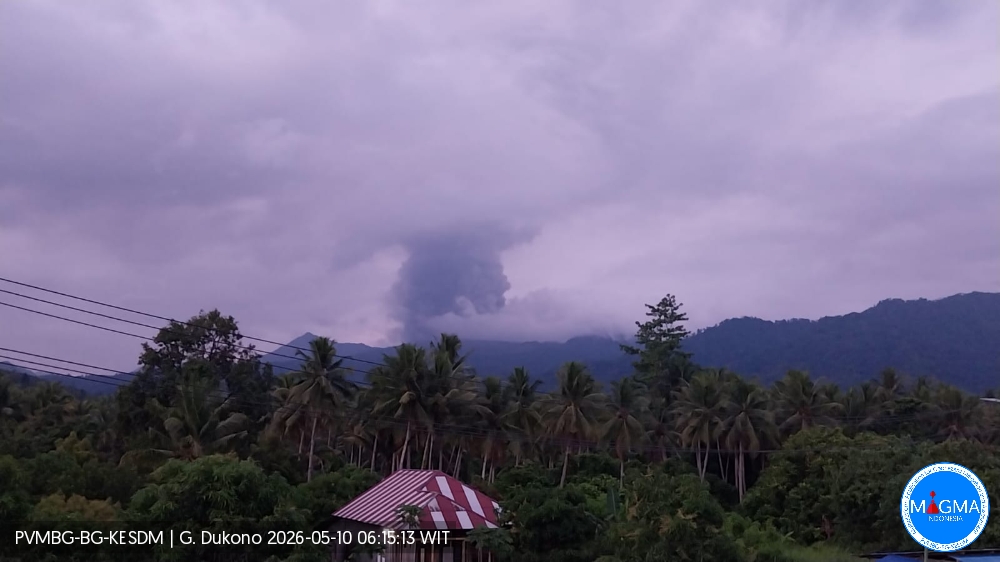
An eruption of Mount Dukono occurred on Sunday, May 10, 2026, at 06:08 WIT, with an observed ash column height of approximately 1000 m above the summit (approximately 2087 m above sea level). This ash column was gray and very dense, oriented to the north and northwest. At the time of writing, the eruption was still ongoing.
Seismic Observations:
92 eruption earthquakes with amplitudes ranging from 6 to 34 mm and durations from 30.06 to 344.53 seconds.
One distant tectonic earthquake with an amplitude of 24 mm and a duration of 77.54 seconds.
Continuous seismic tremor with an amplitude between 1 and 4 mm, primarily 2 mm.
Sources : BBC , PVMBG.
Photos : PVMBG.
Japan , Sakurajima :
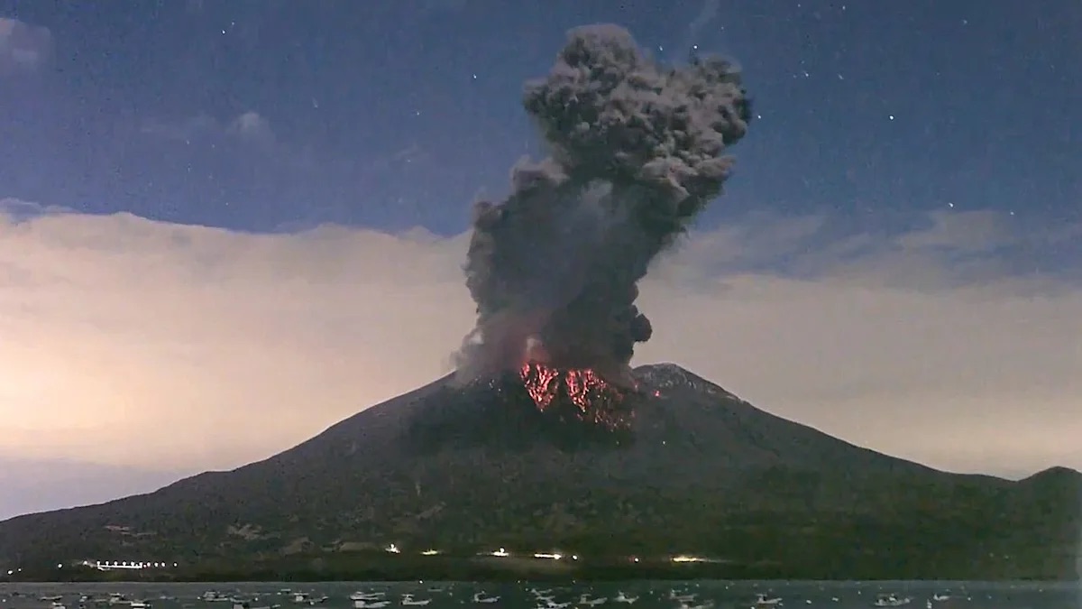
An explosive eruption has occurred at Sakurajima Volcano in Japan.
It is sending ash and smoke up to 3,500 meters high and ejecting volcanic rocks up to 1,300 meters. Ash is currently drifting southeast, and officials are urging caution in nearby areas.
The Japan Meteorological Agency (JMA) reported ongoing eruptive activity at Minamidake Crater (Aira Caldera’s Sakurajima volcano) during 27 April-4 May. Very small eruptive events were periodically detected. Crater incandescence was visible in nighttime webcam images during 1-4 May. The Alert Level remained at 3 (on a 5-level scale), and the public was warned to be cautious within 2 km of both the Minimadake and Showa craters.
The Aira caldera in the northern half of Kagoshima Bay contains the post-caldera Sakurajima volcano, one of Japan’s most active. Eruption of the voluminous Ito pyroclastic flow accompanied formation of the 17 x 23 km caldera about 22,000 years ago. The smaller Wakamiko caldera was formed during the early Holocene in the NE corner of the caldera, along with several post-caldera cones. The construction of Sakurajima began about 13,000 years ago on the southern rim and built an island that was joined to the Osumi Peninsula during the major explosive and effusive eruption of 1914. Activity at the Kitadake summit cone ended about 4,850 years ago, after which eruptions took place at Minamidake. Frequent eruptions since the 8th century have deposited ash on the city of Kagoshima, located across Kagoshima Bay only 8 km from the summit. The largest recorded eruption took place during 1471-76.
Sources: Japan Meteorological Agency (JMA), GVP.
Photo :Auteur inconnu.
Italy , Stromboli :
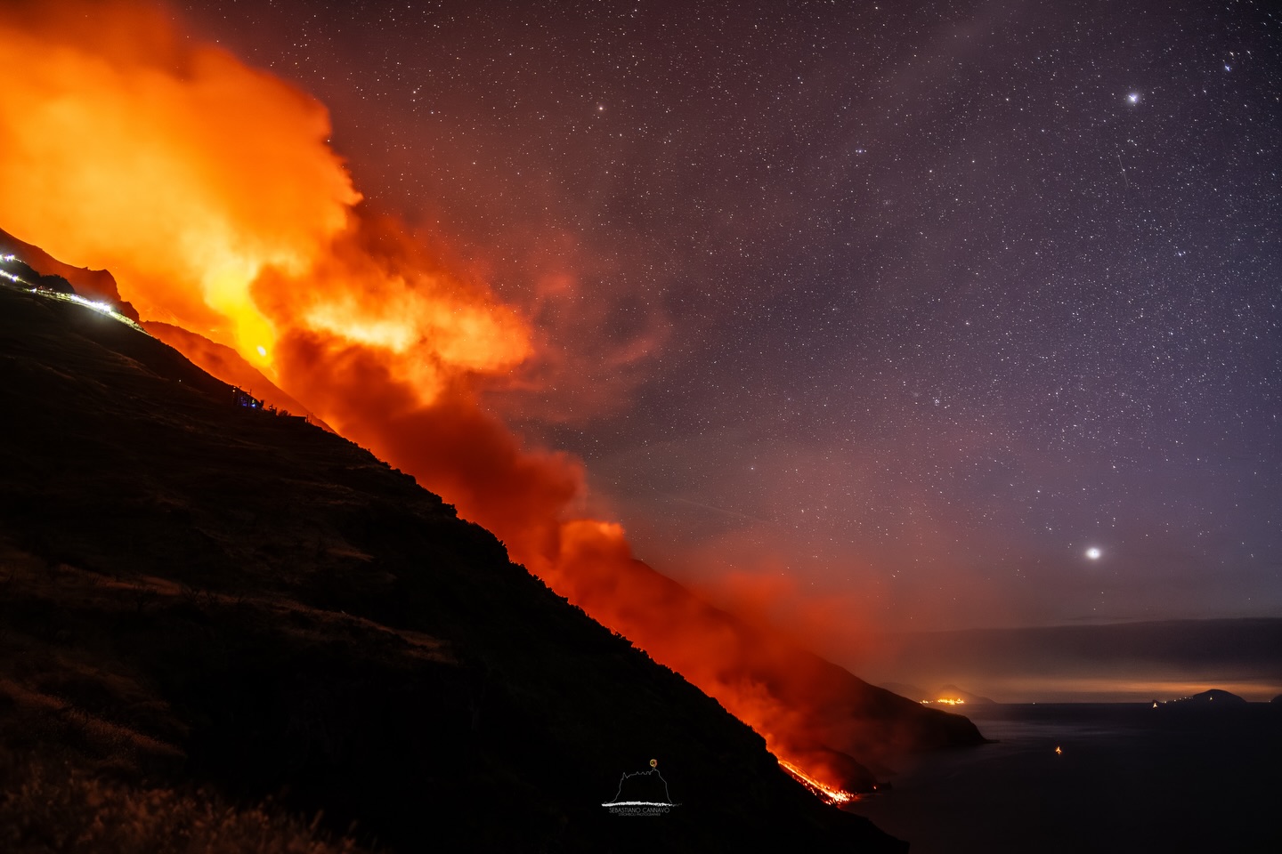
Stromboli Activity Update, May 9, 2026, 5:11 PM (3:11 PM UTC)
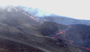
The National Institute of Geophysics and Volcanology, Etna Observatory, announces, based on the analysis of surveillance camera images, that the effusive activity, which began on May 4 (Stromboli Report, May 4, 2026, 11:24 AM UTC), has ended.
After reaching the coastline on May 5 (Stromboli Report, May 5, 2026, 5:33 PM UTC), the lava field experienced a slow deceleration in its flow rate starting on May 6.
This deceleration resulted in a gradual retreat of the lava fronts to increasingly higher altitudes.
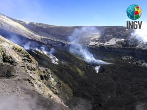
Currently, the lava field is stationary and cooling. Ordinary Strombolian activity continues in the North and Central-South crater areas, and ejections of varying intensity are observed in the North crater area.
From a seismic perspective, the average amplitude of volcanic tremor has stabilized just above the alert threshold since 8:00 UTC.
No significant changes have been observed in the frequency and amplitude of explosion earthquakes.
No significant changes have been detected in the deformation signals recorded by the high-frequency GNSS network.
Further information will be released shortly.
Source : INGV.
Photo : Stromboli stati d’animo / Sebastiano Cannavo.
Colombia , Galeras :
San Juan de Pasto, May 5, 2026, 4:30 PM
Regarding the monitoring of activity at the Galeras volcano, the Colombian Geological Survey (SGC), an agency under the Ministry of Mines and Energy, reports the following:
During the week of April 28 to May 4, 2026, the main variations in monitored parameters, compared to the previous week, were as follows:
● Volcanic activity remains low. No significant variation was recorded in the frequency or energy of earthquakes associated with Galeras. Most of the detected earthquakes correspond to rock fracturing processes within the volcanic edifice.
● Localized seismicity was observed in the volcano’s zone of influence, within 6 km of the crater and at depths not exceeding 12 km from the summit of Galeras (4,200 m altitude). The strongest earthquake, with a magnitude of 2.5, was recorded on May 2nd and located northeast of Galeras. However, it was not felt.
● Low-altitude plumes of white gas, dispersing variably depending on wind direction, have been observed. These plumes originate primarily from the fumarole fields of El Paisita, to the north, and Las Chavas, to the west of the volcanic cone.
● All other volcanic monitoring parameters remained stable. Given these factors, the Geological Survey of Colombia (SGC) recommends closely monitoring the situation by consulting the weekly bulletins and other information disseminated through its official channels, as well as the instructions of local and departmental authorities and the National Unit for Disaster Risk Management (UNGRD).
Volcanic activity remains at the yellow alert level: active volcano exhibiting changes in the baseline behavior of monitored parameters and other manifestations.
Source et photo : SGC.
Ecuador , El Reventador :
Monitoring and Maintenance of Stations on El Reventador Volcano
A technical team from the Geophysical Institute of the National Polytechnic School (IG-EPN), coordinated by the National Secretariat for Risk Management (SNGR), received support from a helicopter and crew from Ecuadorian Army Aviation Group No. 45 – Pichincha, belonging to Army Aviation Brigade No. 15 – Paquisha, to conduct surface activity monitoring on El Reventador Volcano and maintain its permanent instrumental monitoring network. These tasks were carried out between April 15 and 20, 2026.
The IG-EPN commends the professionalism demonstrated by the aircraft crew during the overflights, under the command of Captain Fernando Martínez.
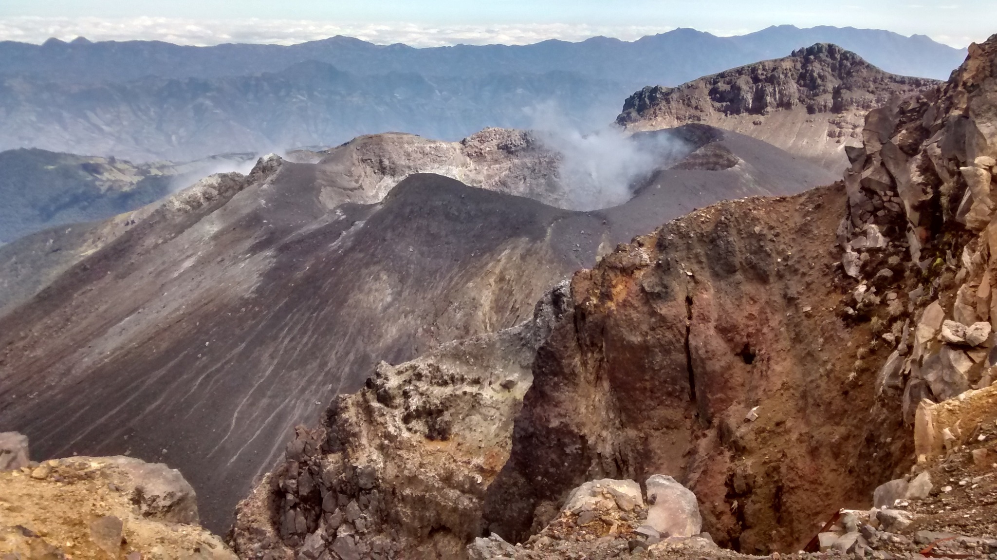
The El Reventador volcano is located in the province of Sucumbíos, about 90 km east of the city of Quito. On November 3, 2002, it was responsible for the largest eruption recorded in Ecuador in the last century. Since then, it has maintained consistently high levels of activity, continuously monitored by the IG-EPN (National Geographic Institute).
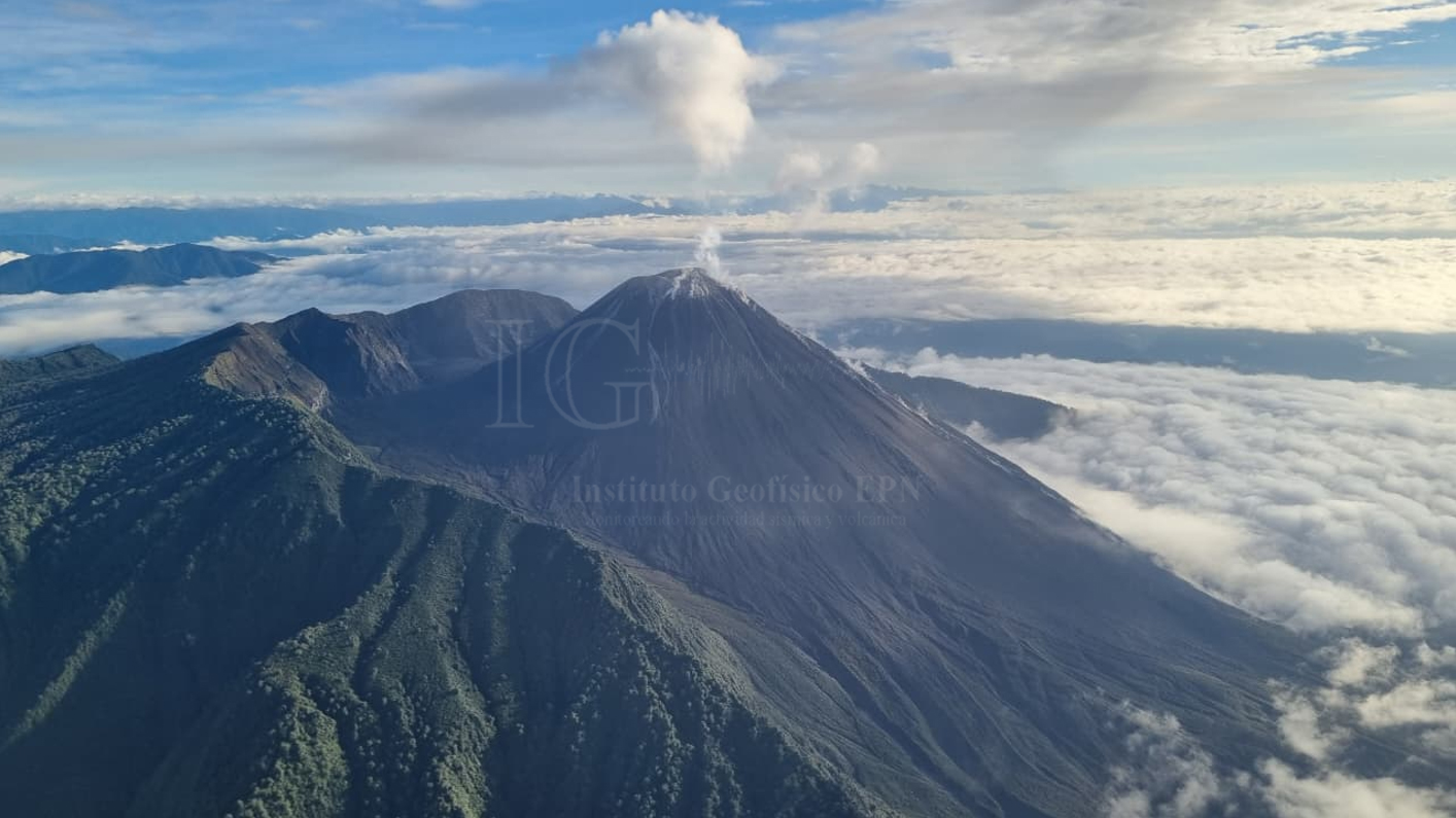
Panorama of El Reventador volcano during a surface activity monitoring overflight.
Volcanic monitoring work
During the monitoring overflight, surface activity at the volcano was characterized by explosions within the crater, particularly at the southern vent, occurring approximately every 20–30 minutes; this is typical of the volcano’s activity levels in recent years. These explosions generated moderately concentrated gas and ash plumes that reached between 500 and 1000 meters above the crater rim and followed a predominant northeasterly direction, influenced by the prevailing winds in the area. Some of these explosions also generated small pyroclastic flows that descended the southern flank. The lava flow down the southeast flank has remained active since 2024 but is now confined to the upper zone of the volcanic edifice.
The maximum recorded apparent temperatures reached > 350°C in the volcano’s crater. These temperatures are considered high, although they are likely underestimated due to the conditions under which the measurements were taken. During gas measurements (MultiGAS), a peak in sulfur dioxide (SO2) and another in carbon dioxide (CO2) were detected, both of magmatic origin at low environmental concentrations.
High temperatures and the emission of magmatic gases are considered normal for an erupting volcano, such as El Reventador.
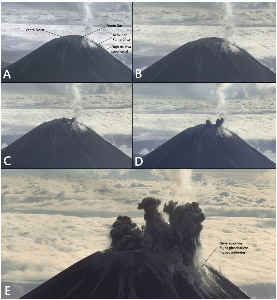
Sequence of visible-range images obtained during the surveillance overflight. A) Onset of fumarolic activity. B) First explosion in the southern vent. C and D) Second explosion and growth of the eruptive column. E) Generation of a pyroclastic flow or a burning cloud descending the southern flank of the volcano. NOTE: The scope of all phenomena described in this image is limited to the upper zone of the volcano, with the exception of the ash columns, which can cause minor volcanic material to fall in the nearest towns.
Maintenance and rehabilitation of the station network
Several tasks were carried out during this mission, including the rehabilitation of the seismic, infrasound, and visual camera stations at Copete. Similarly, valuable components were recovered from the Charlie station, whose purpose is to analyze the data obtained during its operation. Copete and Charlie are among the highest-risk stations due to their location and lack of accessibility.
The Copete station provides valuable information for issuing timely alerts to the community regarding lahar generation, ash cloud dispersal, and pyroclastic flow development.
Source : IGEPN
Photos : Freddy Vásconez, 19 avril 2026 / IG-EPN , Marco Almeida, 19 avril 2026 / IG-EPN