March 29 , 2026.
La Réunion Island , Piton de la Fournaise :
Press release from the Paris Institute of Earth Physics / Piton de la Fournaise Volcanological Observatory, March 28, 2028 – 3:40 PM local time – 11:40 AM UTC
Start of Tremor
Since approximately 3:00 PM (local time), a low-amplitude volcanic tremor has been recorded again. According to OVPF recordings, the source of this signal is located on the south-southeast flank. This signal, still weak, could indicate a resumption of eruptive activity, most likely at the last eruptive cone of the eruption that began on February 13, 2026.
At this stage, no visual confirmation of surface lava flow has been obtained from webcams due to unfavorable weather conditions. Consequently, the actual resumption of the surface eruption cannot yet be confirmed. The presence of this tremor nevertheless indicates the emission of hot, incandescent gases at the surface, and suggests the possibility of a lava flow in the short term. Resumptions of eruptive activity after interruptions have already been observed several times at Piton de la Fournaise, notably during the eruptions of August-October 2015 and February 2019. The OVPF (Volcanological Observatory of Piton de la Fournaise) continues to closely monitor the evolution of the activity.
Press release from the Paris Institute of Earth Physics / Piton de la Fournaise Volcanological Observatory, March 28, 2028 – 7:40 PM local time – 3:40 PM UTC
Visual confirmation
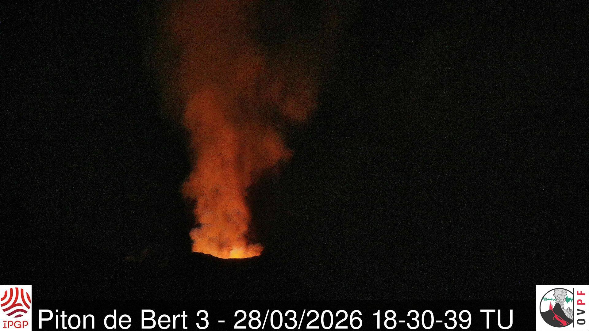
Following the recording of eruptive tremor since 3:00 PM (local time, 11:00 AM UTC), the observatory’s webcams confirm the arrival of magma at the surface at the level of the last eruptive cone of the eruption that began on February 13, 2026.
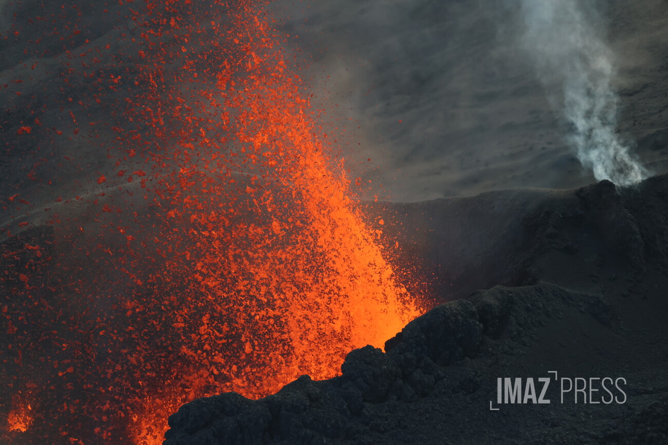
Even though the tremor has been increasing since this afternoon, it remains of very low amplitude, indicating that degassing activity and lava flow remain very weak. This observation is consistent with visual reports, which show that very few projections are visible above the cone.
Press release from the Paris Institute of Earth Physics / Piton de la Fournaise Volcanological Observatory, March 29, 2028 – 7:15 a.m. local time – 7:15 a.m. UTC
Eruption in progress
Summary
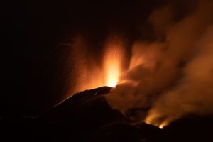
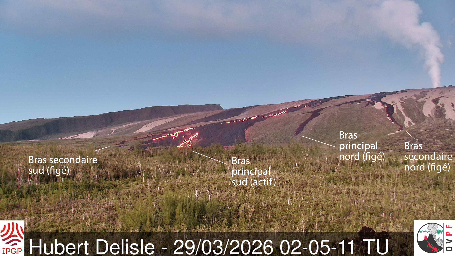
The eruption that began on February 13, 2026, resumed on March 28 at approximately 3:00 p.m. local time. Only one eruptive site is active on the south-southeast flank, at the cone formed between February 13 and March 25. Only the main southern lava flow is being replenished. Minor lava projections are observed at the eruptive cone. The eruptive tremor (an indicator of lava and gas flow) gradually increased late yesterday before stabilizing and then increasing slightly again this morning.
Observations at the various sites
After a pause observed between March 25 (4:30 PM local time) and March 28, the eruption that began on February 13, 2026, on the south-southeast flank of the volcano resumed on March 28 around 3:00 PM local time.
The eruptive site remains on the south-southeast flank of the volcano at an altitude of 2056 m, at the cone formed between February 13 and March 25.
Activity gradually resumed during the afternoon of March 28 (see OVPF-IPGP press releases of March 28). Last night, degassing and minor lava projections were observed at the eruptive cone. Lava tube activity has also resumed downstream of the cone, with visible resurgences in the lava field formed between February 13 and March 25, 2026. These resurgences were again visible in the Grandes Pentes area from 11:42 PM local time on March 28 on the main southern arm.
With the resumption of activity, a replenishment of the platform formed between March 16 and 25 is possible, as well as an intensification of the gas plume at the point where it enters the ocean.
Indeed, even though it is now of lower intensity, a gas plume is still present at the point where the lava enters the ocean. This plume is mainly composed of water vapor, hydrochloric acid (HCl), and fine particles.
Instrumental Observations
During the eruption’s pause between March 25 (4:30 PM local time) and March 28 (3:00 PM local time), summit seismicity remained weak, but deep seismicity was recorded. This seismicity was located west of the Bory crater, between 6 and 7 km below sea level. This deep seismicity generally indicates magma rising towards the shallow reservoir located approximately 1.5-2 km below the summit.
Concurrently, slight inflation of the edifice has been recorded over the last three days, indicating the repressurization of the shallow magma reservoir.
The intensity of the eruptive tremor (an indicator of lava and gas flow) gradually increased at the end of yesterday before stabilizing and then increasing slightly again at the start of this morning. Surface flow rates, estimated from satellite data via the HOTVOLC platform (OPGC – Clermont Auvergne University), have indicated values below 4 m³/s since the resumption of activity. It should be noted that these estimates can vary significantly depending on cloud cover and become zero in the event of total cloud cover. Current activity in the lava tube also tends to underestimate the flow rates observed by satellite methods.
Source : OVPF / IPGP.
Photos : OVPF , Richard Bouhet/Imazpress .com
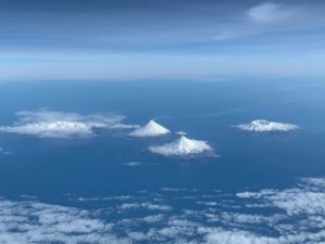
Hawaii , Mauna Kea :
HAWAIIAN VOLCANO OBSERVATORY INFORMATION STATEMENT , U.S. Geological Survey
Friday, March 27, 2026, 2:09 PM HST (Saturday, March 28, 2026, 00:09 UTC)
On Thursday, March 26 between 2:00 p.m. and 10:00 p.m. HST, the USGS Hawaiian Volcano Observatory detected a swarm of about 28 tectonic earthquakes beneath the northeast side of Mauna Kea, in the Hāmākua region. These earthquakes mainly occurred at depths between 5–10 km (3–6 miles) below the ground surface. The largest of these events were two magnitude 3 earthquakes, and each had a couple of felt reports. During the first few hours of the swarm, the earthquake rates were lower. Following the two magnitude 3 earthquakes, which occurred about one hour apart, the seismic activity stopped for about 90 minutes before resuming.
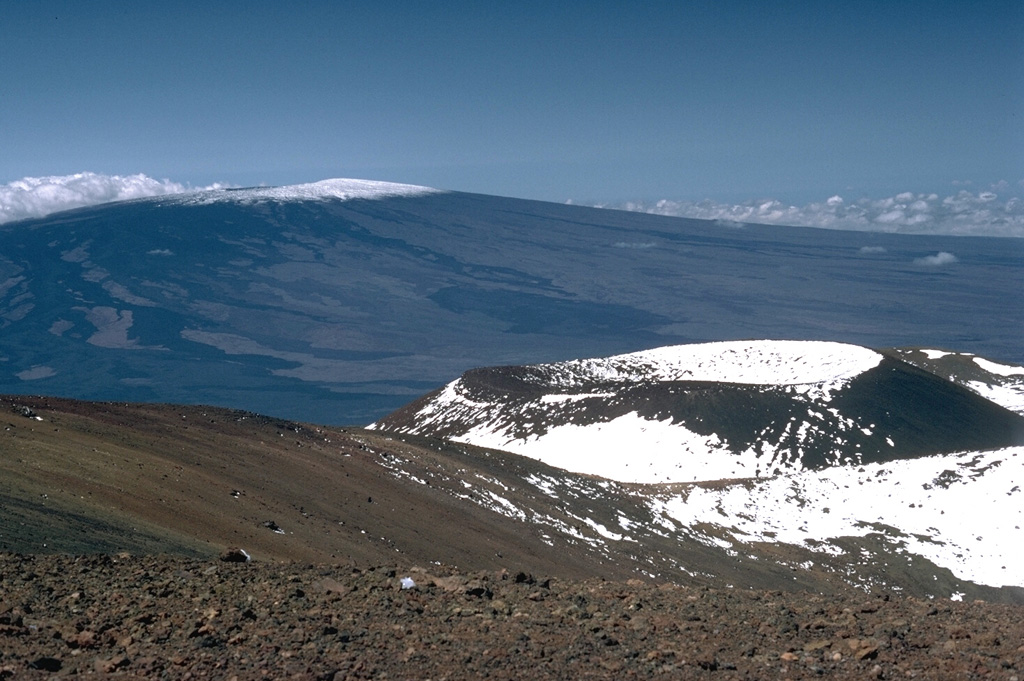
The Pu‘u Haukea scoria cone is one of many recent cones that have formed near the Mauna Kea summit. Mauna Loa is in the background with unvegetated lava flows visible down its flanks. Nearly the entire Mauna Loa surface seen here consists of lava flows erupted during the past 4,000 years.
These tectonic events are not related to magma movement. Over the past 25 years, similar clusters of earthquakes in this region have occurred in 2002, 2004, 2006, 2008, and 2010 along with a scattering of isolated earthquakes overtime. Maximum magnitudes have all been in the magnitude 3 range with most earthquakes less than magnitude 2. The depth of these earthquakes put them beneath the Mauna Kea edifice and into the underlying Kohala volcano, whose rift zone extends all the way to the submarine Hilo ridge east of Mauna Kea. These earthquakes appear to be related to periodic release of stress in the elongated Kohala edifice. Stress gradually accumulates over time and is most likely due to the weight of the island. They do not appear to be directly related to the older submarine Laupāhoehoe slump or to flexural bending of the underlying oceanic lithosphere.
The USGS Hawaiian Volcano Observatory will continue to closely track changes in seismic activity and monitor Hawaiian volcanoes for any changes.
Source : HVO.
Photo : Lee Siebert, 1987 (Smithsonian Institution)
Kamchatka , Sheveluch :
KVERT VOLCANIC ACTIVITY NOTICE (VAN)
Issued: 20260329/0252Z
Volcano: Sheveluch (CAVW #300270)
Current aviation colour code: RED
Previous aviation colour code: orange
Source: KVERT
Notice Number: 2026-31
Volcano Location: N 56 deg 38 min E 161 deg 19 min
Area: Kamchatka, Russia
Summit Elevation: 3283 m (10768.24 ft), the dome elevation ~2500 m (8200 ft)
Volcanic Activity Summary:
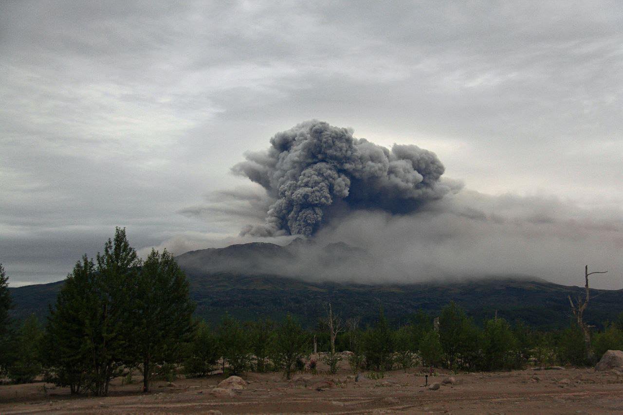
An explosive-extrusive eruption of the volcano continues, accompanied by powerful gas-steam activity; a new block of lava continues to grow in the northern part of the lava dome. Video data showed explosions sent ash up to 11 km a.s.l., and ash cloud extended to the east of the volcano.
An explosive-extrusive eruption of the volcano continues. Ash explosions up to 12 km (39,400 ft) a.s.l. could occur at any time. Ongoing activity could affect international and low-flying aircraft.
Volcanic cloud height:
11000 m (36080 ft) AMSL Time and method of ash plume/cloud height determination: 20260329/0222Z – Video data
Other volcanic cloud information:
Distance of ash plume/cloud of the volcano: 10 km (6 mi)
Direction of drift of ash plume/cloud of the volcano: E / azimuth 80 deg
Time and method of ash plume/cloud determination: 20260329/0240Z – Video data
Start time of explosion and how determined: 20260329/0217Z – Video data
Duration of explosion: ~ 30 min
Source : Kvert.
Photo : Viktor Frolov , Institut de volcanologie et de sismologie DVO RAN, @IViS_DVO_RAN ( archive).
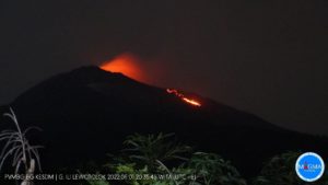
Indonesia , Lewotobi Laki-laki :
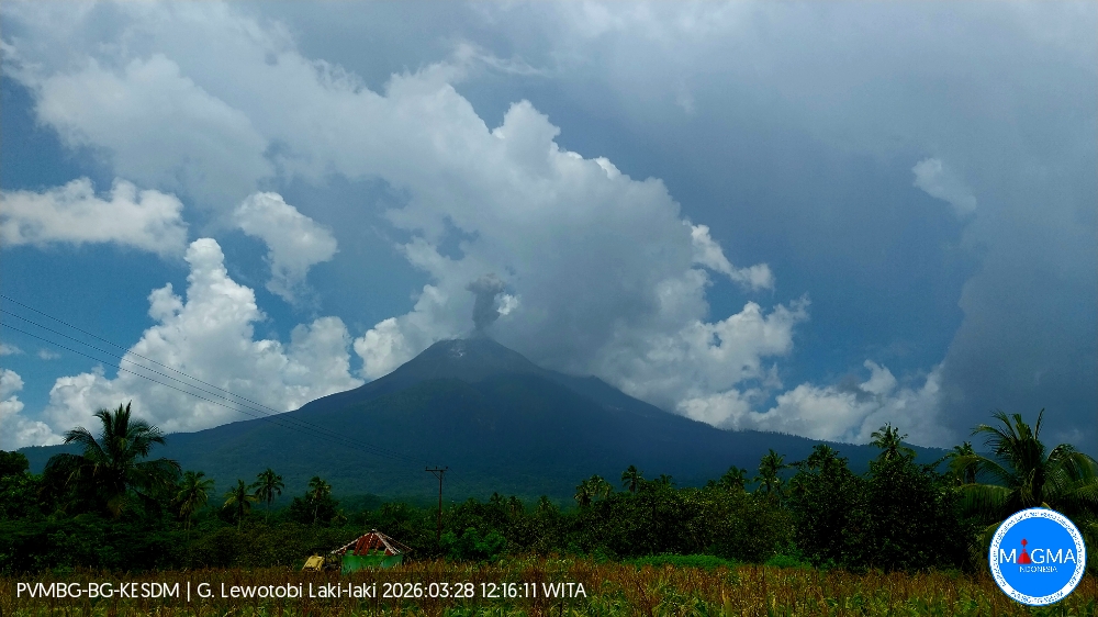
An eruption of Mount Lewotobi Laki-laki occurred on Saturday, March 28, 2026, at 12:14 PM WITA. The observed ash column rose approximately 400 meters above the summit (about 1984 meters above sea level). This gray ash column was highly intense and directed southwest. The eruption was recorded by a seismograph with a maximum amplitude of 5.9 mm and a duration of 86 seconds.
VOLCANO OBSERVATORY NOTICE FOR AVIATION – VONA
Issued : March 28 , 2026
Volcano : Lewotobi Laki-laki (264180)
Current Aviation Colour Code : ORANGE
Previous Aviation Colour Code : orange
Source : Lewotobi Laki-laki Volcano Observatory
Notice Number : 2026LWK024
Volcano Location : S 08 deg 32 min 20 sec E 122 deg 46 min 06 sec
Area : East Nusa Tenggara, Indonesia
Summit Elevation : 5069 FT (1584 M)
Volcanic Activity Summary :
Eruption with volcanic ash cloud at 04h14 UTC (12h14 local).
Volcanic Cloud Height :
Best estimate of ash-cloud top is around 6349 FT (1984 M) above sea level or 1280 FT (400 M) above summit. May be higher than what can be observed clearly. Source of height data: ground observer.
Other Volcanic Cloud Information :
Ash cloud moving to southwest. Volcanic ash is observed to be gray. The intensity of volcanic ash is observed to be thick.
Remarks :
Eruption recorded on seismogram with maximum amplitude 5.9 mm and maximum duration 86 second.
Source et photo : PVMBG.
Ecuador , Quilotoa :
The Quilotoa volcano is located 83 km southwest of Quito, in the province of Cotopaxi, within the Los Ilinizas Ecological Reserve, in a mountainous area between the municipalities of Zumbagua (12.5 km south of the crater) and Sigchos (17 km north of the crater).
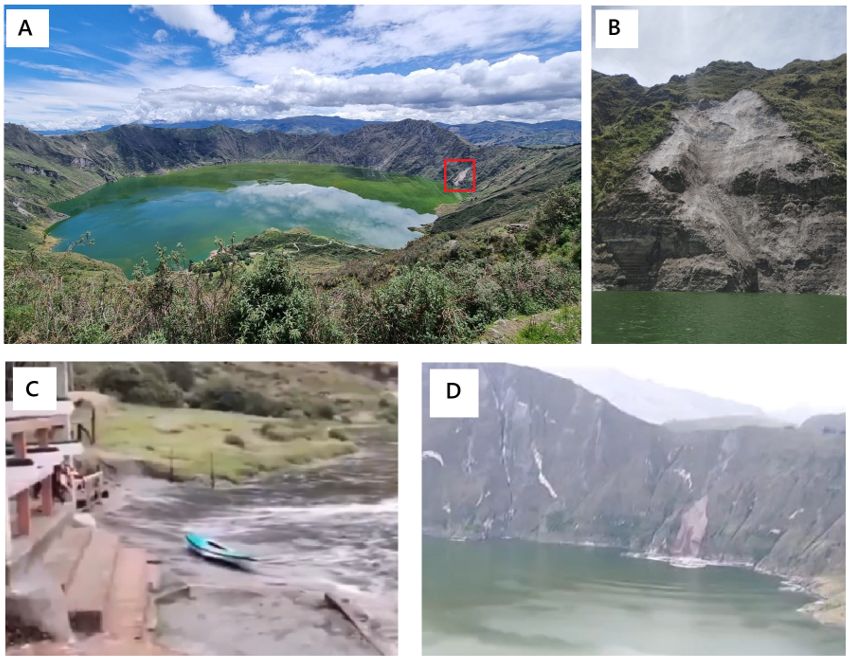
On March 12, 2026, a small landslide occurred on the southeastern flank of the volcano. As it fell into the lagoon, this landslide generated waves (seiches). Figure 2-A shows a panoramic view of the volcano’s crater and the location of the landslide southeast of the lagoon (near Shalalá). Figure 2-B shows the landslide in the foreground, as seen from inside the lagoon. Figures 2-C and 2-D show screenshots from two videos taken from social media. We can see the waves produced on March 12 in the port area (fig. 2-C) and the landslide that generates the waves propagating on the surface of the lagoon (fig. 2-D).
In response to the events of March 12, which caused concern among residents, and as part of monitoring seismic and volcanic activity across the country, the IG-EPN (General Inspectorate of Natural Resources) decided to install two new seismic stations near the volcano. It is the responsibility of local authorities to ensure the safety of the installed equipment.
Conclusions
• Quilotoa Volcano is a potentially active volcano whose last eruption was 800 years ago and which constantly emits CO₂ through its lagoon. This phenomenon generally goes unnoticed, except in the bubbling zone.
• The seiche (waves) that went viral on social media occurred on March 12 and was caused by a small landslide on the southeast shore of the lagoon, unrelated to volcanic activity.
• No anomaly of activity was detected at the volcano, which could indicate a process of unrest.
• The value of diffuse CO₂ emitted by the lagoon and measured on March 17, 2026, is the lowest recorded since monitoring began by the IG-EPN in 2024. This value is comparable to previous measurements carried out by Melian et al. (2021). Further measurements are needed to better understand the behavior of diffuse degassing in the lagoon. If degassing does not completely remove the excess CO₂, the volcano could pose a risk due to its potential for limnic eruptions, which would require the implementation of mitigation measures (such as the release of deep water to the surface through pipelines), as has been done in other crater lakes around the world (e.g., Lake Nyos in Cameroon).
• Strengthening the Quilotoa volcano monitoring network improves the operational capacity of the IG-EPN (National Polytechnic Institute of Geophysics) to detect potential signs of future reactivation.
Source et photo : IGEPN.