March 18 , 2026.
La Réunion Island , Piton de la Fournaise :
Press release from the Paris Institute of Earth Physics / Piton de la Fournaise Volcanological Observatory, March 18, 2026 – 8:00 a.m. local time – 4:00 a.m. UTC
Eruption in progress
The eruption that began on February 13, 2026, shortly after 10:00 a.m. (local time) at Piton de la Fournaise continues.
Only one eruptive site remains active on the south-southeast flank of the volcano, visible from Piton de Bert. The eruptive cone is now well-formed and continues to close gradually. Few ejecta now rise above the height of the cone.
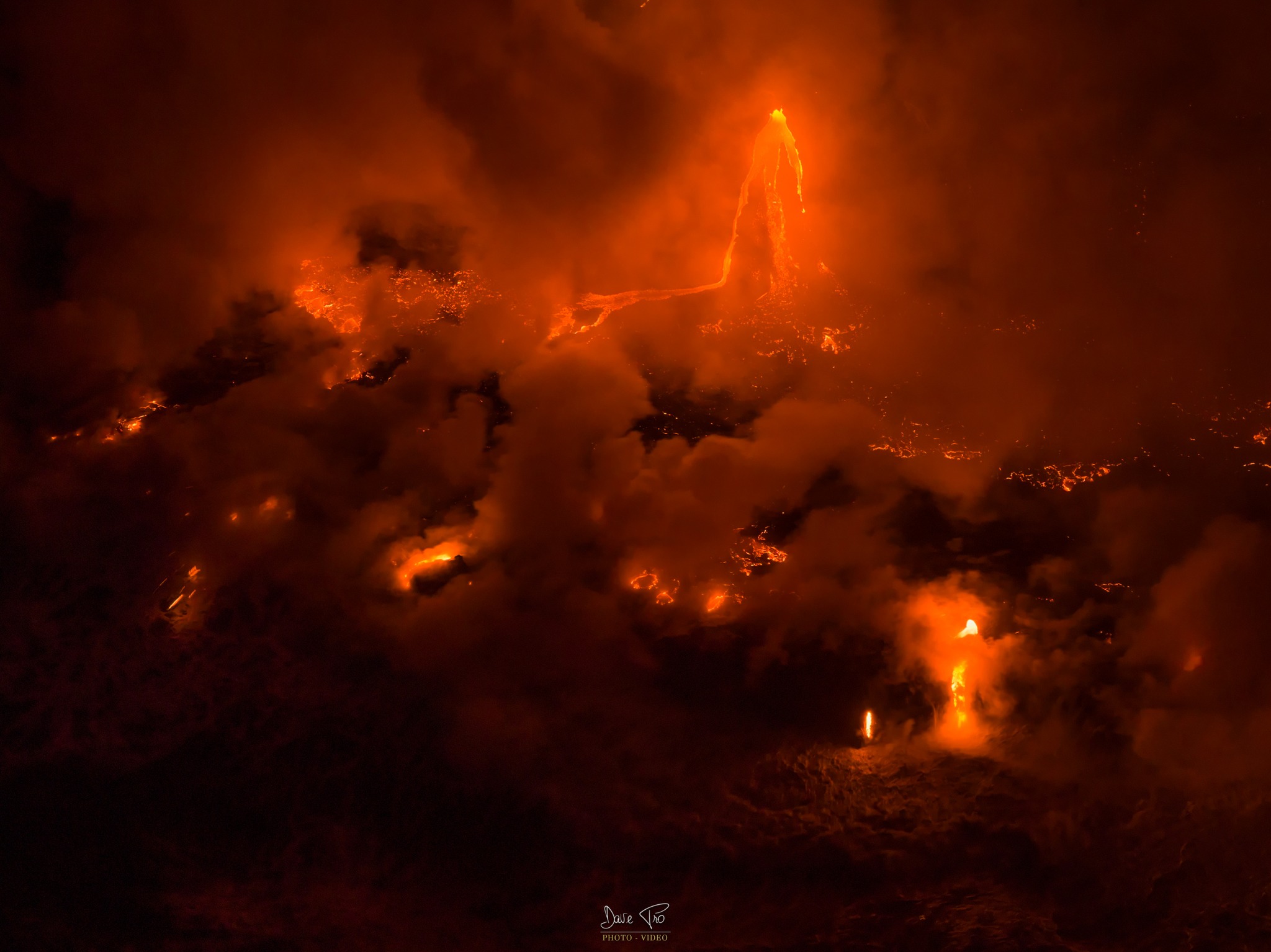
With the lateral closure of the cone, significant lava tube activity is now established. Since March 3, lava flows have been visible again in the Grandes Pentes area.
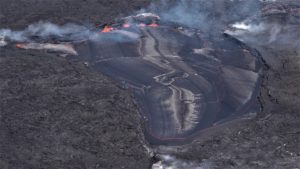
The lava field emitted from the eruptive site still forms two main arms. The front of the northern arm remains stationary approximately 2.6 km from National Route 2 (RN2), at an altitude of about 660 m.
The southern arm has split into several secondary arms, which continue their advance at highly variable speeds, influenced by the topography and vegetation encountered along their path, which can locally slow or channel the lava flow. After crossing National Route 2 (RN2) on March 13, the lava reached the ocean on March 16 at approximately 12:20 a.m. local time. Upstream of the road, several resurgences and secondary lava flows are visible on the south side, but their progress is very slow and does not currently pose a threat to RN2. At the point of contact between the lava and the ocean, a platform continues to form and widen, resulting from the accumulation of lava and its fragmentation into fine particles. Several secondary channels form downstream of the RN2 before the lava flow reaches the sea.
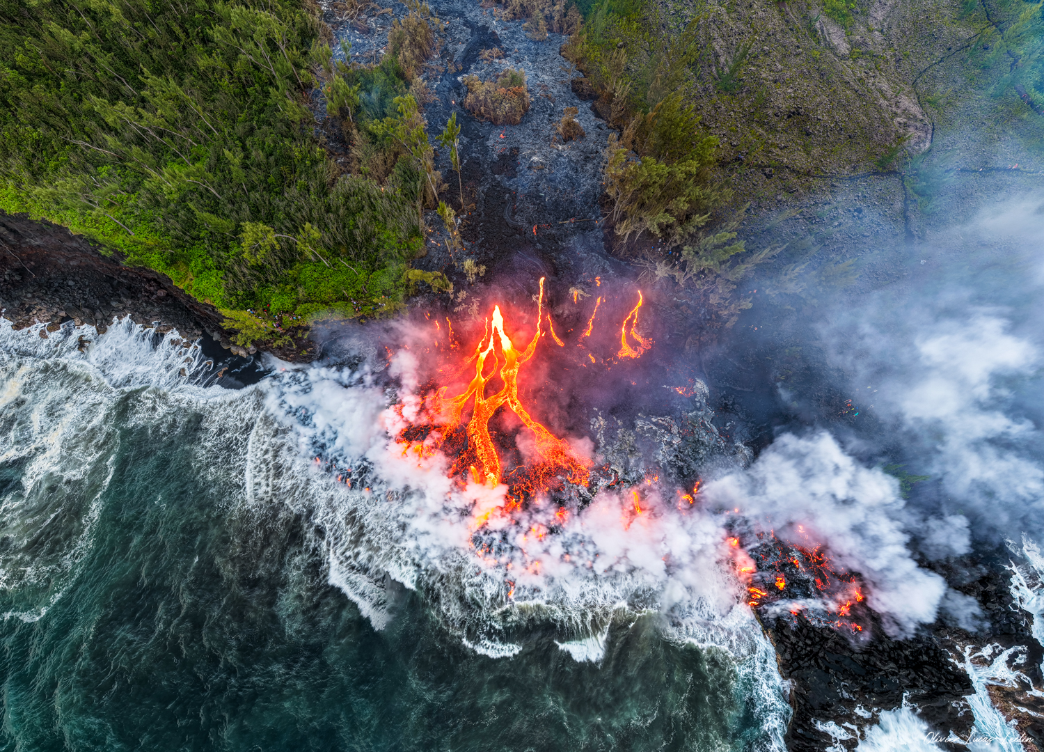
At the point where the lava enters the sea, a plume develops. This plume is primarily composed of water vapor, hydrochloric acid (HCl), and fine particles. When the lava, at a temperature of approximately 1100°C, comes into contact with seawater rich in sodium chloride, it generates an acidic aerosol in the form of fine droplets. This plume also contains particles of pulverized lava and fragments of volcanic glass, which can be carried hundreds of meters to kilometers by the wind.
This plume, sometimes called « lava haze, » can be irritating and corrosive to the respiratory tract, skin, and eyes. Its dispersion is highly dependent on local weather conditions. Furthermore, the sudden contact between the lava and the water can generate localized explosions, projecting molten material and jets of high-temperature steam in the immediate vicinity of the point of entry into the sea.
As in previous days, seismic activity remains low.
Inflation of the volcano appears to have ceased. For the past few days, the baselines crossing the summit have stabilized and no longer show any expansion. This stabilization will need to be confirmed in the coming days.
The cessation of inflation and the absence of deflation suggest that an equilibrium has been established between the magma feeding the shallow reservoir and that emitted at the eruptive site, preventing significant pressurization of the reservoir.
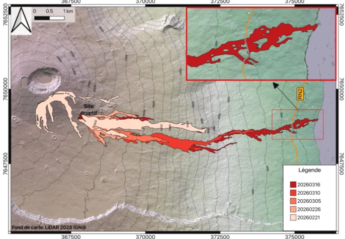
Mapping of the lava field evolution up to March 16, 2026. The outlines were estimated from Sentinel-2 and Planet images acquired on March 16, as well as coherence maps calculated from Sentinel-1 interferograms for flows at earlier dates. Eruptive fissures are shown in black, and the current eruptive site is represented by a triangle (© OI²/ISDeform – OSUL, OPGP-LMV, University of Reunion Island, OVPF-IPGP).
Since March 14, a significant increase in eruptive tremor has been observed, accompanied by intermittent « gas piston » phases. These signals reflect pulsed degassing in the conduit, linked to the ascent of gas pockets through the magma. Over the past 24 hours, these gas piston phases have themselves appeared intermittent, with sequences of stopping and restarting. The intensification of tremor is consistent with the increase in SO₂ fluxes measured by the NOVAC network on March 15-16, suggesting an increase in degassing activity that remains to be confirmed.
In contrast, lava flow rate estimates (TADR) from satellite data show contrasting results: HOTVOLC data indicate generally stable values, while MIROVA suggests a slight increase in the eruptive flux, with values remaining below 10 m³/s. This divergence can be explained by observational biases,
particularly related to meteorological conditions (cloud cover), the development of lava tunnel flows, and the lava flow entering the sea, which limit the detection of thermal radiation. A potential increase in the eruptive flux therefore remains to be confirmed in the coming days.
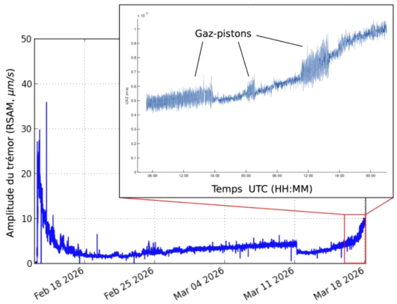
Evolution of tremor amplitude (an indicator of lava and gas emission at the surface) between February 13 and March 17, 2026, at the FOR seismological station located near the eruption (©WebObs/OVPF-IPGP).
The fact that the increase in tremor appears more pronounced than that of the lava flow can be explained by several factors. Firstly, tremor, which reflects both magma flow and surface degassing, can be amplified by the progressive construction of the eruptive cone, modifying the flow and degassing conditions near the vent. Secondly, uncertainties affecting satellite estimates can mask actual variations in flow rate. Finally, partial gas-magma decoupling in the conduit is also possible: in this case, an increase in degassing—the main contributor to tremor according to several recent studies at Piton de la Fournaise—could occur without a significant change in the lava flow rate estimated by thermal methods.
Alert Level 2.2
Source : OVPF / IPGP.
Photos : Dave Pro / FB , Olivier Lucas-Leclin / FB , OVPF.
Italy , Stromboli :
WEEKLY BULLETIN, March 9, 2026 to March 15, 2026 (Publication date: March 17, 2026).
ACTIVITY SUMMARY
Based on monitoring data, the following points should be noted:
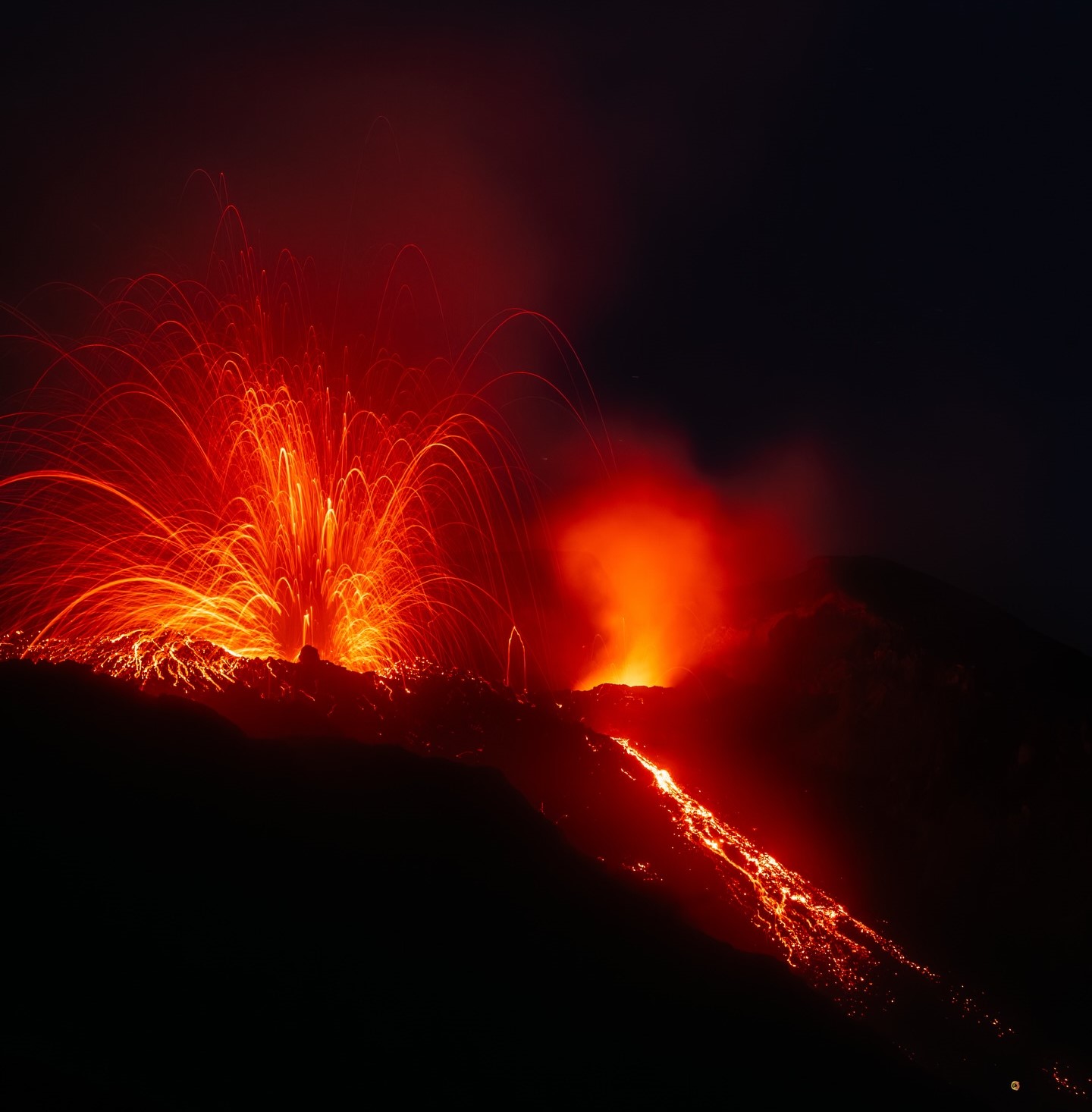
1) VOLCANOLOGICAL OBSERVATIONS: During this period, ordinary Strombolian-type eruptive activity was observed, interrupted by weak ejections from the North Crater area.
The total hourly frequency fluctuated between average (10 events/hour) and high (20 events/hour). The intensity of the explosions was mostly low to medium in the North and Central-South Crater areas.
2) SEISMOLOGY: The monitored seismic parameters showed no significant variation.
3) GROUND DEFORMATION: The signals recorded by the GNSS network showed no significant variation.
The tilt network is not operational.
4) GEOCHEMISTRY: SO2 flux at an average level.
CO2 flux from the ground in the Pizzo area (STR02): increased to very high values, then returned to high values in recent days.
C/S ratio in the feather at average values.
Helium isotope ratio (R/Ra) dissolved in the thermal aquifer: data from the last sample taken on February 26, 2026, are at high values (R/Ra = 4.49).
CO2 flux from the ground in the San Bartolo area: at average to high values.
CO2 flux STR01 at average values.
5) SATELLITE OBSERVATIONS: Thermal activity observed by satellite in the summit area was generally moderate.
VOLCANOLOGICAL OBSERVATIONS
During the observation period, Stromboli’s eruptive activity was characterized by analyzing images recorded by the INGV-OE monitoring cameras located at an altitude of 190 m (SCT-SCV) and at Punta dei Corvi (SPCT). Explosive activity was primarily produced by five eruptive vents located in the North Crater area and by at least two vents located in the Central-South area.
Observations of explosive activity captured by the monitoring cameras
Five active vents were observed in the North Crater area (N), two in sector N1, and three in sector N2. These produced explosive activity of low (less than 80 m high) and medium intensity (less than 150 m high) intensity. In addition, weak but continuous ejection activity was observed at the vents in sector N2. The eruptive products were primarily coarse materials (volcanic bombs and lapilli). The average frequency of explosions ranged from 10 to 18 events per hour.
In the Central-South Crater (CS) area, two main vents were observed, exhibiting explosions of fine material mixed with coarse material, of low to medium intensity. The average frequency of explosions ranged from less than one event per hour to two events per hour.
March 18, 2026, 02:43 (01:43 UTC)
The National Institute of Geophysics and Volcanology, Etna Observatory, reports that analysis of surveillance camera images shows ongoing effusive overflow activity in the North Crater area, producing a lava flow whose fronts are located in the upper part of the Sciara del Fuoco.
From a seismic perspective, the average amplitude of volcanic tremor is currently within normal limits. No significant variations have been observed in the frequency and amplitude of explosion earthquakes. Analysis of high-frequency GNSS network data reveals no significant deformation.
Source : INGV.
Photo : Stromboli stati d’animo / Sebastiano Cannavo
Iceland , Reykjanes Peninsula :
Magma accumulation beneath Svartsengi now exceeds 23 million cubic meters since the last eruption
Updated March 17
Magma intrusion and an eruption along the Sundhnúkur crater row remain the most likely scenario
Largest magma accumulation between eruptions since the onset of the eruption sequence
A long pause between eruptions does not mean the eruption sequence has ended
The Icelandic Meteorological Office is revising scenario assessments
Hazard assessment unchanged and valid until March 31
Ground uplift and magma accumulation continue at a similar rate as in recent weeks, with magma inflow slow but steady. According to model calculations, more than 23 million cubic meters of magma have now accumulated beneath Svartsengi since the last eruption in July of last year. Magma accumulation beneath Svartsengi has never been greater since the beginning of this eruption sequence.

As magma accumulation continues and pressure in the system increases, the most likely scenario is a magma intrusion from Svartsengi toward the Sundhnúkur crater row, which could lead to an eruption. Since the volume of magma beneath Svartsengi is now greater than previously during this eruption sequence, it is possible that the next eruption could be larger than earlier ones, if the magma reaches the surface either partially or fully. The most likely location of a fissure or magma intrusion is in the area between Stóra-Skógfell and Sýlingarfell, where previous intrusions and eruptions along the Sundhnúkur crater row have occurred. The most likely location for a fissure eruption or dike intrusion is between Stóra-Skógfell and Sýlingarfell, where previous events have occurred within the Sundhnúkur crater row. However, the potential fissure opening area may be more extensive, extending from Grindavík in the south to areas northwest of Keilir.
The Icelandic Meteorological Institute is continuing its analysis of the possible evolution of volcanic activity and will present its findings at the end of March. It is important to note that a long pause between eruptions does not necessarily indicate the end of the eruptive sequence at the Sundhnúkur craters.
Source : IMO Iceland
Photo : mbl.is/Árni Sæberg
Philippines , Kanlaon :
KANLAON VOLCANO ERUPTION BULLETIN , 18 March 2026 , 2:00 AM
Eruption Data:
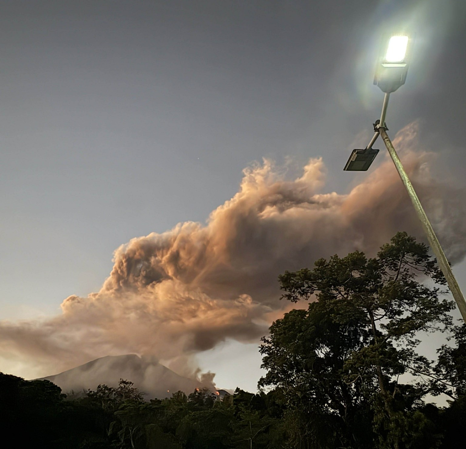
Another short-lived, moderately explosive eruption occurred at the summit crater of Kanlaon Volcano at 06:07 PM of 15 March 2026, which lasted a minute based on seismo-acoustic recordings in 14 stations of the Kanlaon Volcano Network. The explosion transitioned into weaker but continuous and often obscured emission of ash that persisted for 3:49 hours and was accompanied by weak volcanic tremor. The eruption generated a grayish eruption column that rose 5,000 meters above the vent and drifted to the general east before being blown by monsoon winds to the general south. Large incandescent ballistic fragments launched by the explosion were thrown as far as a kilometer from the summit crater. Pyroclastic density currents or PDCs, hazardous mixtures of hot volcanic gas, ash and fragmented rock, descended the southern upper slopes within a kilometer of the summit crater.
The explosive onset generated a shock wave that was recorded at a maximum of 181 Pascals by an infrasound station approximately five kilometers east of the crater and was heard as a booming or rumbling sound within an 18-kilometer radius.
Eruption Impacts:
Ash from the eruption was dispersed over an extensive area of the central Negros Island Region or NIR, with the heaviest ashfall experienced in the Municipality of La Castellana, Negros Occidental. Sulfurous fumes and shockwave observations were also reported. Regional, Provincial and local authorities and residents have reported moderate to light ashfall on 55 barangays in 12 cities/municipalities of the NIR.
In addition to the above impacts, incandescent ballistics ignited two patches of forest fire on the upper southeastern margins of the vegetation canopy on the volcano slopes. The fires burned throughout the night and died out at approximately 03:30 AM of 16 March 2026 based on camera observations. DOST-PHIVOLCS’ station closest to the crater, the Upper Mananawin Observation Station (VKUM; 1,800 masl), was engulfed by the fire and is presumed to be completely damaged.
Monitoring Data Prior to the Eruption:
Similar to the 19 and 26 February 2026 eruptions, the 15 March 2026 eruption was preceded by relatively low seismic activity and volcanic gas emission. Only one volcanic earthquake recorded for the day preceded the event. Sulfur dioxide or SO2 emission averaged 1,085 tonnes/day immediately prior to the eruption, but this was preceded by a decrease to 589 tonnes/day on 14 March 2026. In comparison, SO2 has been continuously degassed at an average rate of 2,755 tonnes/day since 3 June 2024, when eruptive unrest began, and at an average rate of 1,401 tonnes/day since 1 January 2026. In contrast to the February 2026 eruptions, however, based on electronic distance meter (EDM) and GPS data, short-term deflation of the edifice that began after the February 2026 events preceded the 15 March 2026 eruption. In any case, the overall parameters indicate that repetitive blockage or sealing of established volcanic gas pathways of a deep magma source (or closed-system degassing) and resulting pressurization of the edifice generated the most recent eruption. This has been a repeating eruption mechanism since the volcano’s first moderately explosive activity in June 2024, producing nearly similar seismic characteristics and volcanic hazards.
Current Outlook:
Alert Level 2 is still maintained over Kanlaon Volcano but the alert status may be raised should explosive eruption recur in the next few days, or in effect become more frequent.
Source : Phivolcs.
Photo : Regine Delos Santos Tomaquin.
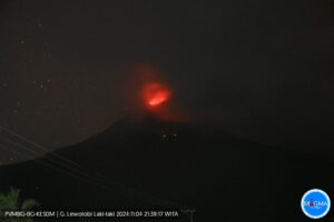
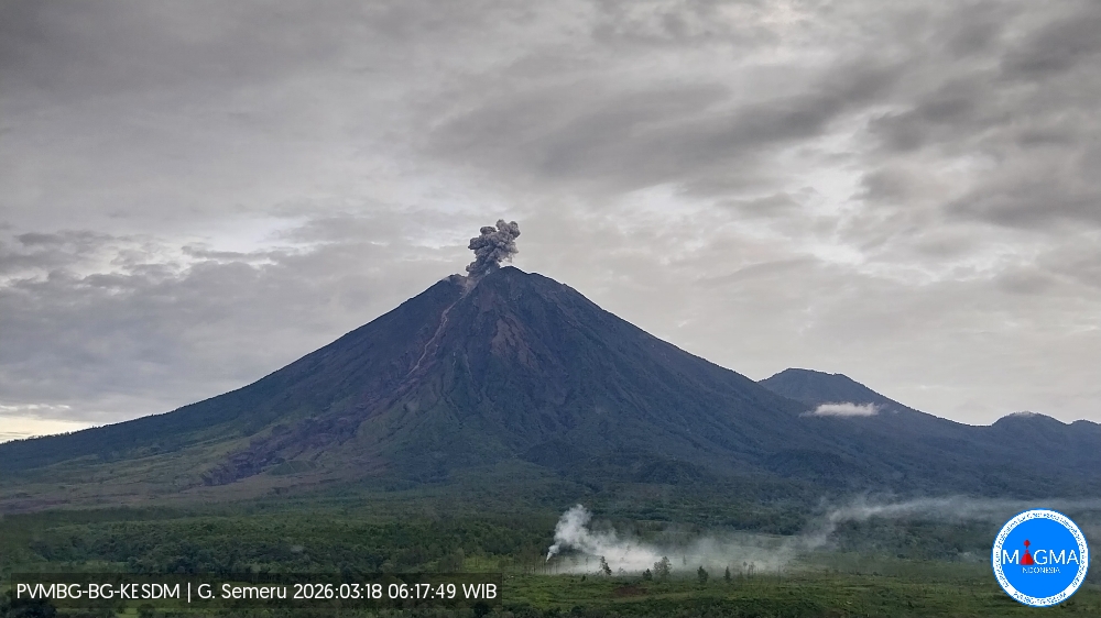
Indonesia , Semeru :
Mount Semeru experienced an eruption on Wednesday, March 18, 2026 at 06:16 WIB. An ash column was observed approximately 700 meters above the summit (at an altitude of about 4,376 meters). This ash column, white to gray in color, was highly intense and directed northeast. The eruption was recorded by a seismograph with a maximum amplitude of 22 mm and a duration of 93 seconds.
VOLCANO OBSERVATORY NOTICE FOR AVIATION – VONA
Issued : March 18 , 2026
Volcano : Semeru (263300)
Current Aviation Colour Code : ORANGE
Previous Aviation Colour Code : orange
Source : Semeru Volcano Observatory
Notice Number : 2026SMR555
Volcano Location : S 08 deg 06 min 29 sec E 112 deg 55 min 12 sec
Area : East java, Indonesia
Summit Elevation : 11763 FT (3676 M)
Volcanic Activity Summary :
Eruption with volcanic ash cloud at 23h16 UTC (06h16 local).
Volcanic Cloud Height :
Best estimate of ash-cloud top is around 14003 FT (4376 M) above sea level or 2240 FT (700 M) above summit. May be higher than what can be observed clearly. Source of height data: ground observer.
Other Volcanic Cloud Information :
Ash cloud moving to northeast. Volcanic ash is observed to be white to gray. The intensity of volcanic ash is observed to be thick.
Remarks :
Eruption recorded on seismogram with maximum amplitude 22 mm and maximum duration 93 second.
Source et photo : PVMBG