March 14 , 2026.
La Réunion Island , Piton de la Fournaise :
Press release from the Paris Institute of Earth Physics / Piton de la Fournaise Volcanological Observatory, March 14, 2026 – 6:45 a.m. local time – 2:45 a.m. UTC
Eruption in progress
The eruption that began on February 13, 2026, shortly after 10:00 a.m. (local time) at Piton de la Fournaise continues.
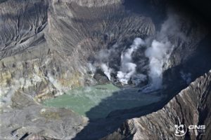
Only one eruptive site remains active on the south-southeast flank of the volcano, visible from Piton de Bert. The eruptive cone is now well-formed and continues to close progressively. Few ejecta now exceed the height of the cone.
With the lateral closure of the cone, significant lava tube activity is now established. Since March 3, lava flows have again been visible in the Grandes Pentes area with a new flow arm.
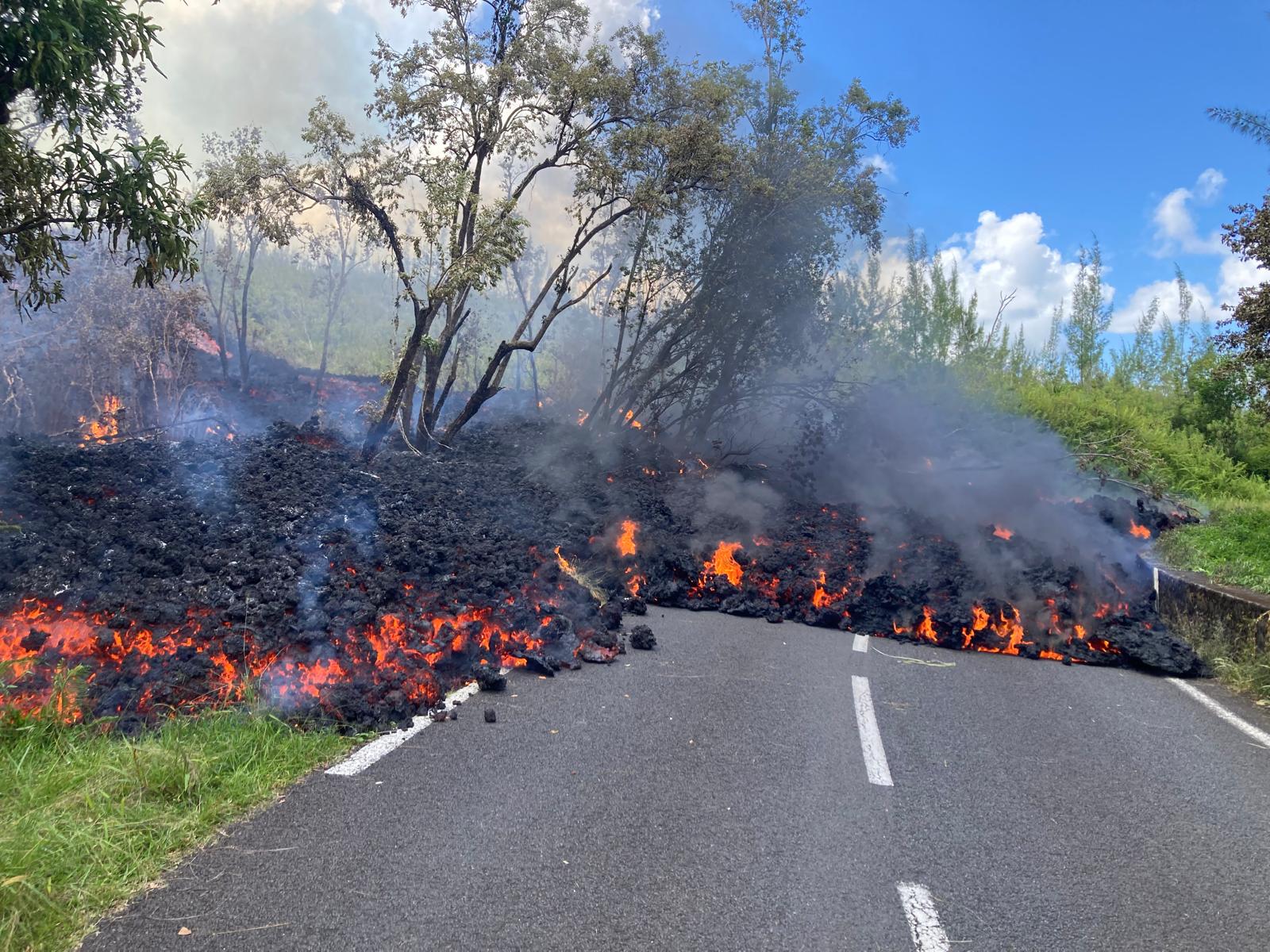
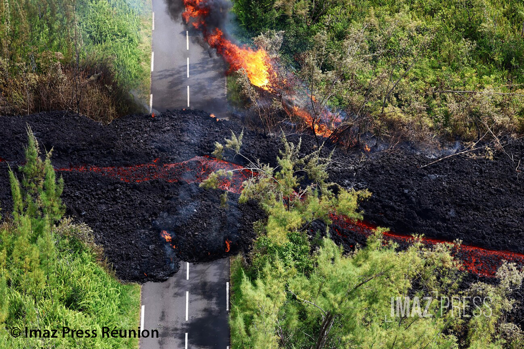
The lava field erupting from the eruption site still forms two main arms. The northern arm’s front remains stationary approximately 2.6 km from National Route 2 (RN2), at an altitude of about 660 m.
The southern arm continues its advance, with highly variable speeds due to factors such as the topography and vegetation encountered along its path, which can locally slow or channel the lava flow. After crossing RN2 at three points on March 13, at 8:02 a.m., 8:37 a.m., and 12:35 p.m. local time, the various secondary flow arms continue their advance toward the ocean. By the morning of March 14, over a width of approximately 260 m, virtually the entire section of RN2 is now covered by lava flow.
At 5:00 a.m. local time on March 14, the lowest point of the flow was located approximately 310 m from the ocean. As in previous days, seismic activity remains low.
The inflation of the volcano, visible particularly on the summit GNSS stations and at the base of the terminal cone, continues. Since the end of February, the baselines crossing the summit have recorded an increase in distance, indicating a progressive re-expansion of the volcano.
This inflation indicates a repressurization of the magma supply system, possibly linked to magma recharge from the shallow reservoir.
Following a sharp drop on March 11 (indicating lava and gas emissions at the surface), and then a period of stabilization, the tremor is slowly increasing again.
Surface flow rates, estimated from satellite data via the HOTVOLC (OPGC – Clermont Auvergne University) and MIROVA (University of Turin) platforms, have indicated values of less than 5 m³/s over the past 24 hours.
It should be noted that these estimates can vary significantly depending on cloud cover and become zero in the event of total cloud cover. Current lava tube activity also tends to underestimate the flow rates observed by satellite methods. Estimating surface lava flow rates allows us to track the volume of lava emitted; thus, since the beginning of the eruption, between 13 and 15 million m³ of lava have been emitted to the surface.
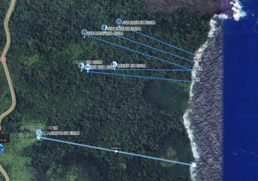
Location of secondary flow arm fronts at 5:00 AM local time on March 14 (©SDIS)
Summary
Since the end of February, GNSS network data has indicated inflation of the edifice. This development is thought to be linked to a repressurization of the magma supply system, possibly associated with a new phase of magma recharge in the shallowest reservoir.
Given the current low seismic activity, the probability of new eruptive fissures opening remains low in the short term.
Nevertheless, signs of repressurization increase this probability.
It should also be noted that in the past, eruptive fissures have opened during an eruption without warning signals, such as in August 1998, July 1999, October 1999, December 2006, and March 2019. Indeed, magma propagation at shallow depths can occur aseismically, particularly when the magma has already been degassed.
Alert Level 2.2
Source : OVPF / IPGP.
Photos : Ovpf , Imaz Press , Ovpf .
Indonesia , Karangetang :
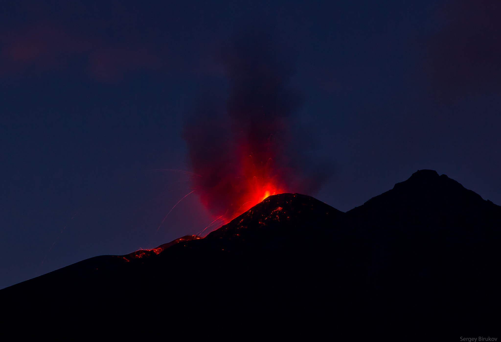
Lava flow activity on Mount Karangetang, North Sulawesi, March 13, 2026.
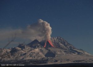
Mount Karangetang is a stratovolcano reaching an altitude of 1,784 meters. It is located on Siau Island. The last eruption occurred on October 9, 2025, in the North Crater (Crater II), where eruptive material, in the form of lava flows, flowed between the Kinali River and the village of Hiung, approximately 1,000 meters from the summit of Mount Karangetang. Volcanic activity has been at Level II (Waspada) since January 11, 2025, at 6:00 PM WITA.
Visual monitoring conducted after the effusive eruption from October 9 to 24, 2025, showed the beginning of a decline in volcanic activity. No lava flows were observed. A rumbling sound from the North Crater has been heard occasionally at the Karangetang monitoring station. The height of the crater’s plumes has varied. In January 2026, they reached a maximum height of 100 meters, and since February 2026, they have not exceeded 50 meters. On March 12, 2026, at 7:00 PM WITA, a flow of incandescent lava was observed in the North Crater, flowing southward toward the Sumpihi River, approximately 1,000 meters from the North Crater.
The seismic observations of February 2025 were dominated by recorded emission earthquakes (972 events), harmonic tremor earthquakes (102 events), non-harmonic tremor earthquakes (191 events), 15 hybrid/multiphase earthquakes, 50 shallow volcanic earthquakes, 94 deep volcanic earthquakes, 2 local tectonic earthquakes, 2 felt earthquakes and 96 distant tectonic earthquakes. From March 1 to 12, 2026, seismicity remained dominated by recorded emission earthquakes (294 events), 11 non-harmonic tremor earthquakes, 4 hybrid/multiphase earthquakes, 5 shallow volcanic earthquakes, 40 deep volcanic earthquakes, 1 local tectonic earthquake, 1 felt earthquake, and 51 distant tectonic earthquakes. According to RSAM data, volcanic activity at Mount Karangetang shows no increase; the curve remains fluctuating.
This increase in seismicity and incandescent lava flows requires heightened vigilance, given the potential hazards of Mount Karangetang, including magmatic eruptions and hot ash clouds that cascade down into the valleys from the eruptive center located in the North and South craters. The risk of explosive eruptions at Mount Karangetang is characterized by the formation of lava domes that collapse and cascade down into the valleys.
Due to this increased seismicity and incandescent lava flows, the activity level remains at Level II (Waspada). The public is advised to avoid entering a 1.5 km radius around the North and South craters, as well as a 2.5 km radius southwest and south of the South crater. The public is urged to remain calm and follow the recommendations of the Geological Survey, through the Center for Volcanology and Geological Hazard Mitigation, and not to be misled by false and irresponsible information regarding the volcanic activity of Karangetang.
Source : PVMBG.
Photo : Irfan FeykOe ( archive).
Chile , Lascar :
Due to a significant increase in internal and surface activity at the Láscar volcano, the National Disaster Prevention and Response Service (SENAPRED) has established a 5-kilometer security perimeter around the active crater. This measure, implemented in the municipality of San Pedro de Atacama, prohibits the movement of people and vehicles and restricts tourism and grazing to protect the population from volcanic instability.
Currently, the area remains under a preventive early warning and a yellow volcanic technical alert, which entails heightened monitoring and increased mobilization of response teams.
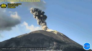
A technical analysis by SERNAGEOMIN revealed that critical changes were observed in February and early March, including a gas plume reaching a height of 1,160 meters and several seismic swarms. These phenomena suggest magma rising to the surface, thus increasing the likelihood of sudden minor explosions. The main risks identified for the surrounding area are the projection of fragments (pyroclasts), ash plumes and emissions of toxic gases.
![]()
As part of immediate measures, the municipality will install restrictive signage on access roads and patrol surrounding routes to ensure compliance with the safety perimeter. Similarly, travel agencies and tour operators have been instructed to inform their clients of the access ban, while the need to set up shelters in case of increased volcanic activity is being assessed. For now, only residents of neighboring rural communities are permitted to enter the critical zone for their usual professional activities.
Monitoring of the Láscar volcano will continue continuously by the Southern Andes Volcanological Observatory (OVDAS) and the National Disaster Prevention and Response System. Regional authorities have emphasized that the safety of residents and tourists is the top priority; therefore, the safety perimeter will remain in effect until technical conditions allow for a reduction in risks. The public is urged to follow only official sources of information to avoid the spread of rumors regarding the development of this geological event.
Sources : El Diario de Antofagasta , Sernageomin.
Photo : Sernageomin / Gabriel Orozco.
Costa Rica , Poas :
OVSICORI-UNA Volcanic Monitoring Weekly Bulletin, March 13, 2026
Latitude: 10.20°N
Longitude: 84.23°W
Altitude: 2687 m
Current Activity Level: Alert
This week, the amplitude of tremors has remained relatively stable. The number of long-period events increased at the beginning of the week but has decreased in recent days. Few events exhibit significant amplitudes. The geodetic network is not recording any significant deformation.
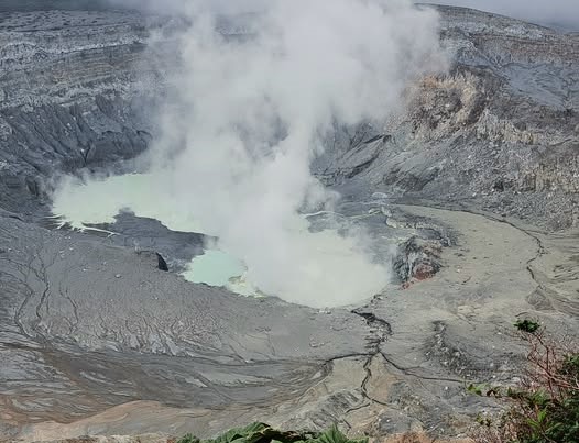
The MultiGAS station recorded weekly average SO₂/CO₂ ratios close to 1.5 ± 0.2 and H₂S/SO₂ ratios below 0.1, values similar to those of the previous week. At the observation point, SO₂ concentrations as high as 3.5 ppm were recorded. DOAS stations detected a sulfur dioxide (SO₂) flux of 106 ± 18 t/d, slightly lower than the previous week’s 159 ± 83 t/d. The level of the hyperacidic lake fluctuated without a general trend this week. SO₂ was detected in the atmosphere by satellite on several occasions this week, with a peak of 33 tonnes on March 11.
Source : Ovsicori .
Photo : Sergio Lucena ( archive).
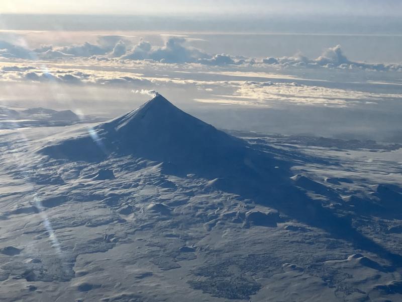
Alaska , Shishaldin :
Signs of volcanic unrest at Shishaldin Volcano continue. Seismic and infrasound activity remain elevated, with numerous small earthquakes, frequent infrasound signals, and volcanic tremor recorded throughout the week. Daytime web camera views consistently showed minor to vigorous steaming, and sulfur dioxide gas emissions were detected in satellite data on March 6, 8 and 13.
Strong northerly winds resuspended loose volcanic ash and dust off the ground surface and carried it to the south on March 11. This phenomenon is not the result of the recent volcanic unrest and occurs during times of high winds and dry snow-free conditions at Shishaldin and other volcanic areas of Alaska.
Source : AVO.
Photo : Beesley, Nick ( archive).