April 18 , 2026.
Alaska , Great Sitkin :
Lava continues to slowly erupt within the summit crater at Great Sitkin Volcano. Minor lava dome growth to the southwest and rockfalls down the south side of the lava field continue. There was also visible advance of the small lava lobe to the southeast this week. Satellite and web camera views were cloudy for most of the week but elevated surface temperatures from the warm, active lava dome were observed when viewing conditions allowed. Seismic activity remains low, with occasional small volcanic earthquakes and seismic signals from small rockfalls within the crater.
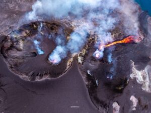
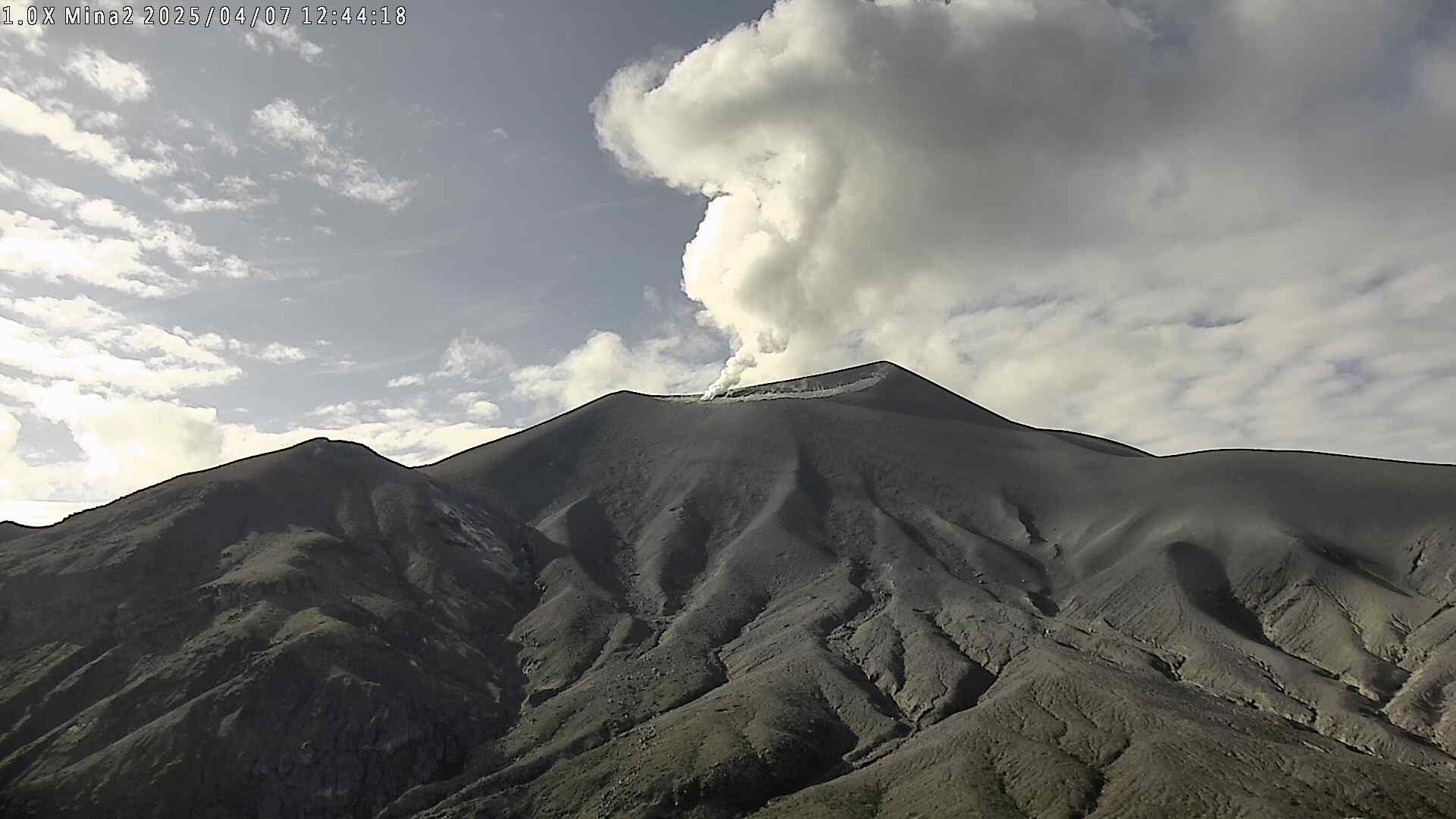
A close up view of the summit crater of Great Sitkin, taken from the air. The currently growing lava flow is steaming in places.
The current lava eruption began in July 2021 and has filled most of the summit crater and advanced into the valleys below. There have been no explosions at Great Sitkin Volcano since an event in May 2021. The volcano is monitored using local seismic and infrasound sensors, satellite data, and web cameras, and regional infrasound and lightning networks.
Source : AVO
Photo : McConnell, Angela
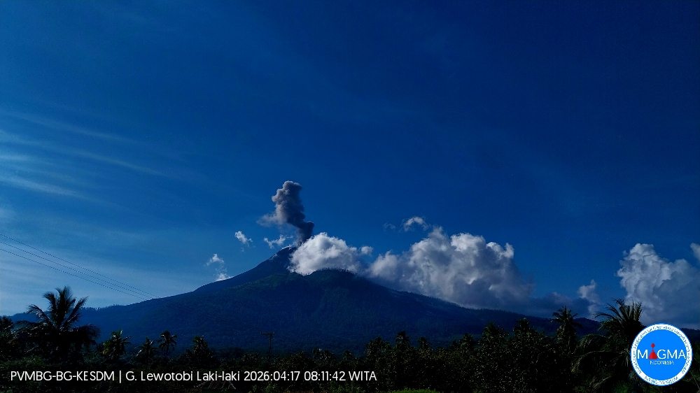
Indonesia , Lewotobi Laki-laki :
An eruption of Mount Lewotobi Laki-laki occurred on Friday, April 17, 2026, at 08:09 WITA. The observed ash column rose approximately 800 meters above the summit (about 2,384 meters above sea level). This ash column was gray and dense, oriented to the north and northeast. The eruption was recorded by a seismograph, with a maximum amplitude of 4.4 mm and a duration of 229 seconds.
Seismic Observations
One eruption earthquake with an amplitude of 4.4 mm and a duration of 229 seconds.
One emission earthquake with an amplitude of 3.7 mm and a duration of 37 seconds.
Sixteen non-harmonic tremors with amplitudes ranging from 2.2 to 4.4 mm and a duration ranging from 69 to 102 seconds.
Nine low-frequency earthquakes with amplitudes ranging from 2.9 to 14.8 mm and a duration ranging from 23 to 30 seconds.
Five deep volcanic earthquakes with amplitudes ranging from 3.7 to 7.4 mm and a total duration ranging from 13 to 20 seconds.
Seven local tectonic earthquakes with amplitudes ranging from 2.9 to 47.3 mm and a total duration ranging from 25 to 31 seconds.
Five distant tectonic earthquakes, ranging in magnitude from 2.9 to 7.4 mm and in duration from 45 to 218 seconds.
Recommendations
1. Residents living near Mount Lewotobi Laki-laki and visitors/tourists are advised to avoid all activity within a 4 km radius of the eruption’s epicenter.
2. The public is urged to remain calm, follow the instructions of local authorities, and disregard rumors from unknown sources.
Source et photo : PVMBG
La Martinique Island , Mount Pelée :
Weekly report from the Paris Institute of Earth Physics / Martinique Volcanological and Seismological Observatory, Saint-Pierre, April 17, 2026, 4:00 PM local time (GMT-4).
Between April 10, 2026, 4:00 PM UTC and April 17, 2026, 4:00 PM UTC, the Martinique Volcanological and Seismological Observatory recorded 576 volcanic earthquakes:
• 568 shallow volcano-tectonic earthquakes. Among them, 44 had a magnitude (local magnitude Mlv or duration magnitude Md) greater than 0.5, and 9 had a magnitude greater than 1; the others were of lower energy. The largest had a magnitude Mlv of 2.51. These earthquakes were located at depths between 0.8 and 3.8 km below the volcano’s summit. Shallow volcano-tectonic seismicity is associated with microfracturing within the volcanic edifice, linked to the overall reactivation of the volcano observed since 2019.
• Five shallow, long-period earthquakes and one shallow hybrid earthquake. One of these has been located and is situated in the same area as the volcano-tectonic earthquakes. The seismic signals of these types of earthquakes are enriched in (or contain only) low frequencies and are associated with the circulation of fluids (gases, hydrothermal fluids) within the volcanic edifice.
• Two deep, long-period earthquakes located at depths of 24 km and 27 km southwest of Mount Pelée, with magnitudes Mlv = 1.07 and Mlv = 0.96, respectively. Deep, long-period earthquakes are characterized by signals containing only low frequencies and are associated with the circulation of magmatic fluids deep within the Mount Pelée volcanic system.
No earthquakes were felt by the population.
The previous week, the OVSM (Swiss Volcanic Observatory) recorded 125 volcanic earthquakes. As of April 17, 2026, and over the past four weeks, the OVSM has observed a total of 735 volcanic earthquakes, an average of 183 to 184 earthquakes per week.
During phases of volcanic reactivation of volcanoes similar to Mount Pelée, seismic activity of varying intensity and frequency is common. The probability of an eruptive activity in the short term remains low. However, based on observations accumulated in recent years, and particularly in recent months, a change in the situation in the medium term (weeks to months) cannot be ruled out.
For more details on observations and interpretations of volcanic activity over the longer term, please refer to the OVSM’s monthly bulletins. The volcanic alert level, in accordance with the measures implemented by the authorities, is currently YELLOW: vigilance.
Source et photo : OVSM-IPGP
Colombia , Puracé – Los Coconucos volcanic chain:
Popayán, April 14, 2026, 3:00 PM
Regarding the monitoring of activity at the Puracé volcano – Los Coconucos volcanic chain – the Colombian Geological Survey (SGC), an agency under the Ministry of Mines and Energy, reports the following:
During the week of April 7-13, 2026, seismicity related to fluid movements within the volcanic edifice continued to be recorded. This seismicity consisted of long-period (LP) earthquakes and tremor pulses. These earthquakes, located below the crater of the Puracé volcano, at a depth of less than one kilometer, were linked to the circulation and release of volcanic gases into the atmosphere. These gases dispersed according to the wind direction, reaching a maximum altitude of 400 meters above the summit of the volcano.
Continuous tremor persists beneath the craters of the Piocollo and Curiquinga volcanoes, at depths of less than 2 km, linked to fluid dynamics within the volcanic system. Fracture seismicity has shown a slight increase in the number of events located on the north-northwest flank of the Puracé volcano, at distances of 2 to 6 km and depths of 3 to 6 km, with magnitudes less than 1.2.
Weak emissions of sulfur dioxide (SO₂) have been recorded, and gases continue to escape through fissures in the craters of the Curiquinga and Piocollo volcanoes. Furthermore, the slow deformation process continues between the Puracé, Piocollo, and Curiquinga volcanoes, as demonstrated by the Curiquinga eruption on January 20, 2025.
In conclusion, the observed variations in the Los Coconucos volcanic chain (Puracé) indicate that the system continues to evolve and that further ash emissions and fallout are possible, depending on the prevailing wind direction. The public is advised to avoid the upper reaches of the volcanic chain and to remain attentive to official bulletins from the Geological Survey of Colombia (SGC).
The alert level for volcanic activity remains yellow: active volcano with changes in the reference behavior of monitored parameters and other manifestations.
Source et photo : SGC.
Hawaii , Kilauea :
HAWAIIAN VOLCANO OBSERVATORY DAILY UPDATE ,U.S. Geological Survey .
Friday, April 17, 2026, 7:16 AM HST (Friday, April 17, 2026, 17:16 UTC)
19°25’16 » N 155°17’13 » W,
Summit Elevation 4091 ft (1247 m)
Current Volcano Alert Level: ADVISORY
Current Aviation Color Code: YELLOW
Overview:
The Halemaʻumaʻu eruption of Kīlauea is paused. Summit inflation is underway at this time, while glow and flames have been visible at south vent over the past day, and faint glow was noted at the north vent overnight. Forecast models suggest that lava fountaining episode 45 will occur sometime between Monday, April 20 and Saturday, April 25.
No significant activity has been noted along Kīlauea’s East Rift Zone or Southwest Rift Zone.
On Saturday, April 11, the USGS Hawaiian Volcano Observatory (HVO) noted an outage of its radio telemetry network, resulting in the loss of multiple monitoring data streams. HVO field engineers rectified the problem—a damaged radio—on April 14, 2026, and affected volcano monitoring data streams have been restored.
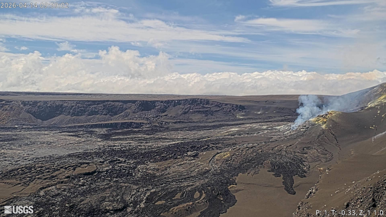
Summit Observations:
Overnight, glow was consistently visible at the Halemaʻumaʻu south vent, along with prolonged periods of intense flaming—likely caused by the ignition of volcanic gases escaping the vent. Faint glow was noted at the north vent for the first time since early Sunday, April 12, and it continues to emit volcanic gases.
Low-level seismic tremor continues during the ongoing eruptive pause. Since the end of lava fountaining episode 44 on April 9, the Uēkahuna tiltmeter (UWD) has tracked approximately 12.3 microradians of inflationary tilt. This instrument recorded 17.6 microradians of deflationary tilt in total during the episode.
With the eruption paused, the sulfur dioxide (SO2) emission rate from Halemaʻumaʻu is likely now varying within a typical range of 1,000 to 5,000 tonnes per day. For the past few days, winds near the eruptive vents have been steady out of the northeast in the mornings before transitioning to more variable directions in the afternoons and evenings.
Rift Zone Observations:
Rates of seismicity and ground deformation remain low in the East Rift Zone and Southwest Rift Zone. SO2 emissions from the East Rift Zone remain below the detection limit.
Source et photo : HVO.