April 17 , 2026.
Japan , Sakurajima :
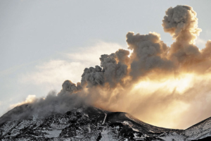
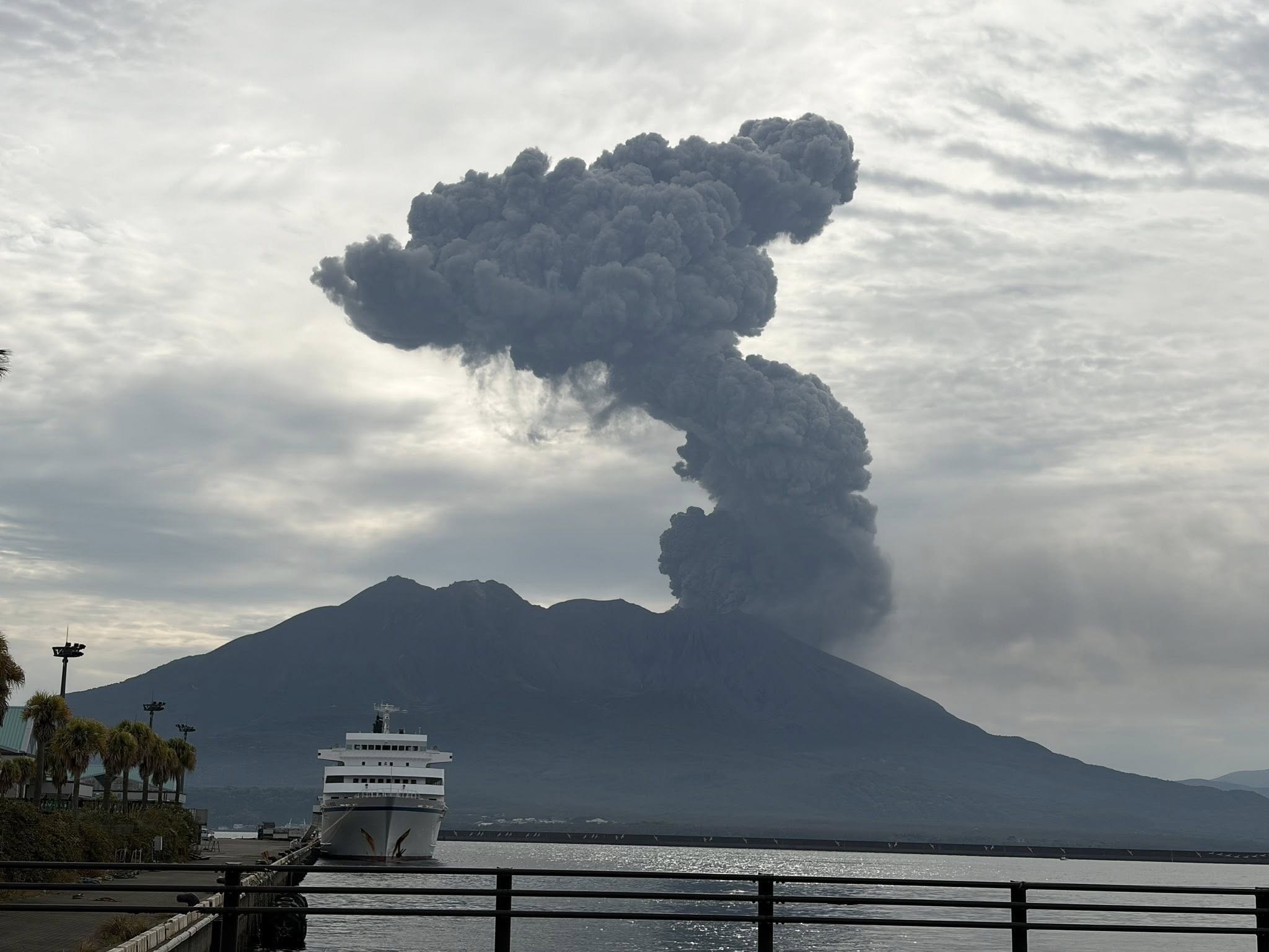
The Japan Meteorological Agency (JMA) reported ongoing eruptive activity at Minamidake Crater (Aira Caldera’s Sakurajima volcano) during 6-12 April. An eruptive event on 9 April generated an ash plume that rose 1.5 km above the crater rim. Eruptive events at 00h26, 15h53, 16h25, and 16h48 on 10 April produced ash plumes that rose 1-1.5 km above the crater run and drifted NE and E. An ash plume from an explosion at 12h04 on 11 April rose 3.4 km above the crater rim and drifted SE. Within an hour a moderate amount of ash fell in Kagoshima City (about 10 km W) and Tarumizu City (10 km SSE). An explosion at 08h28 on 12 April generated an ash plume that rose 2.9 km above the crater rim and drifted S and NE. By 14h00 moderate-to-heavy ashfall had fallen in Kagoshima City. The Alert Level remained at 3 (on a 5-level scale), and the public was warned to be cautious within 2 km of both the Minimadake and Showa craters.
The Aira caldera in the northern half of Kagoshima Bay contains the post-caldera Sakurajima volcano, one of Japan’s most active. Eruption of the voluminous Ito pyroclastic flow accompanied formation of the 17 x 23 km caldera about 22,000 years ago. The smaller Wakamiko caldera was formed during the early Holocene in the NE corner of the caldera, along with several post-caldera cones. The construction of Sakurajima began about 13,000 years ago on the southern rim and built an island that was joined to the Osumi Peninsula during the major explosive and effusive eruption of 1914. Activity at the Kitadake summit cone ended about 4,850 years ago, after which eruptions took place at Minamidake. Frequent eruptions since the 8th century have deposited ash on the city of Kagoshima, located across Kagoshima Bay only 8 km from the summit. The largest recorded eruption took place during 1471-76.
Sources: Japan Meteorological Agency (JMA), GVP.
Photo : Hanna Hanna.
Indonesia , Dukono :
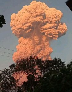
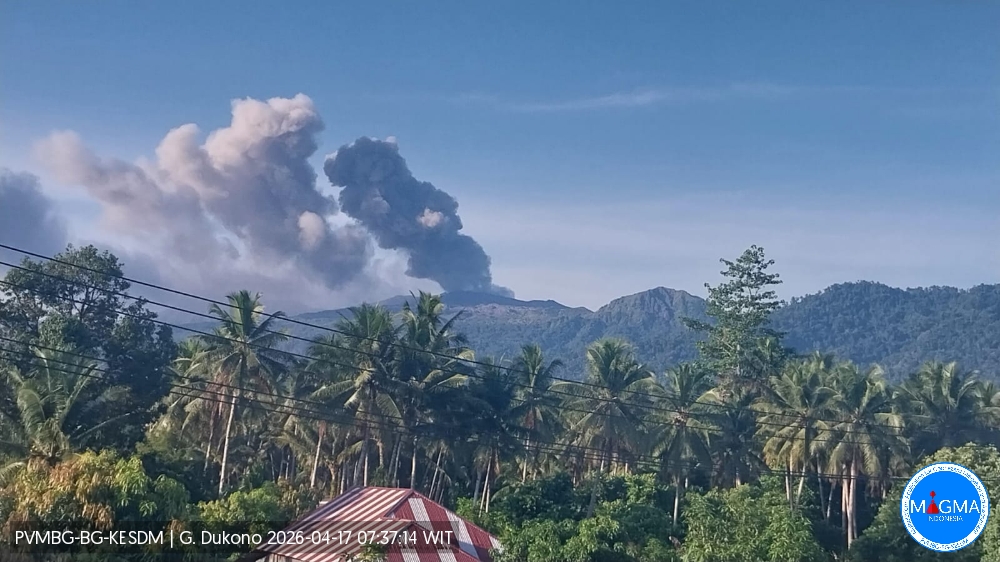
An eruption of Mount Dukono occurred on Friday, April 17, 2026, at 07:28 WIT, with an observed ash column height of approximately 1000 m above the summit (approximately 2087 m above sea level). This ash column, white to gray in color, was highly intense and directed northeast. At the time of writing, the eruption was still ongoing.
Seismic Observations
104 eruption earthquakes with amplitudes between 6 and 34 mm and durations between 22.53 and 55.99 seconds.
1 distant tectonic earthquake with an amplitude of 20 mm and a duration of 61.09 seconds.
1 continuous seismic tremor with an amplitude between 1 and 5 mm, predominantly 2 mm.
Recommendations
(1) Communities living near Mount Dukono and visitors/tourists are advised to refrain from any activity, climbing, or approaching the Malupang Warirang crater within a 4 km radius.
(2) Given that volcanic ash eruptions are periodic and that the dispersion of ash depends on the direction and strength of the wind, making the coverage area unstable, communities near Mount Dukono are advised to always have masks/face coverings available to protect themselves from respiratory risks related to volcanic ash.
Source et photo : PVMBG.
Portugal , Pico Island :
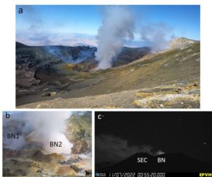
The Centro de Informação e Vigilância Sismovulcânica dos Açores (CIVISA) reported that on 1 April low-magnitude seismic activity was off the NW coast of Pico, in a NE-SW zone along the Faial-Pico channel, W of Madalena to N of Lagido, and encompassing the Cachorro Submarine Volcanic System. The earthquake depths ranged from 20 km deep to near surface. The seismicity was slightly above normal levels; on 9 April the Volcanic Alert Level was raised to V1 (the second lowest level on an 8-level scale) for the Faial-Pico channel.
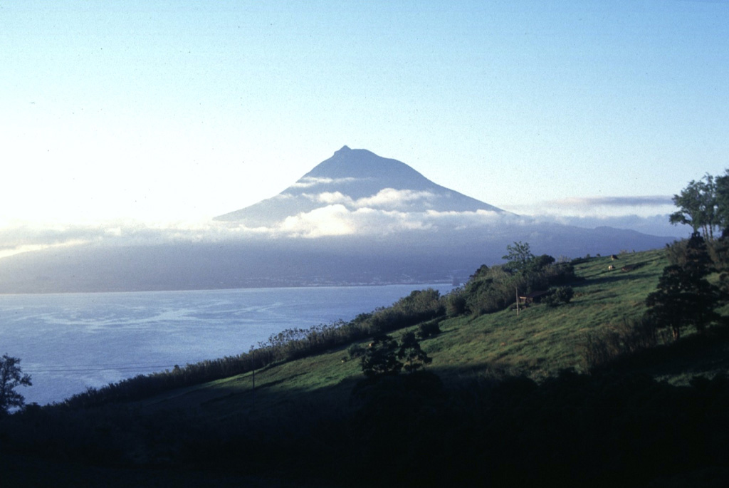
The conical Pico stratovolcano occupies the western end of Pico Island and is the highest volcano in the Azores. The dominantly basaltic edifice lies west of on an older linear volcano with numerous flank cones that forms most of the 46-km-long island. It was constructed over the Montanha volcanic complex on the eastern side of the island and is capped by a 500-m-wide summit crater that is overtopped by a small steep-sided cone. An eruption beginning in 1562 from the Sao Roque Piedade/Planalto da Achada fissure zone produced lava flows that reached the northern coast. Two fissures erupted on the NNW flank and SE flank of Pico volcano in 1718, with lavas reaching the north and south coasts. Lava flows from a fissure on the SE flank in 1720 reached the ocean.
Sources: Centro de Informação e Vigilância Sismovulcânica dos Açores (CIVISA), GVP.
Photo : Rick Wunderman, 1997 (Smithsonian Institution).
Philippines , Taal :
The Philippine Institute of Volcanology and Seismology (PHIVOLCS) reported eruptive activity at Taal during 8-14 April. The seismic network recorded 1-7 daily volcanic earthquakes; additionally, there was a two-minute period of tremor on 10 April and another tremor period lasting one hour and 32 minutes on 11 April. Daily gas-and-steam emissions were diffuse, rising as high as 800 m above the crater rim and generally drifting NW, W, and SW.
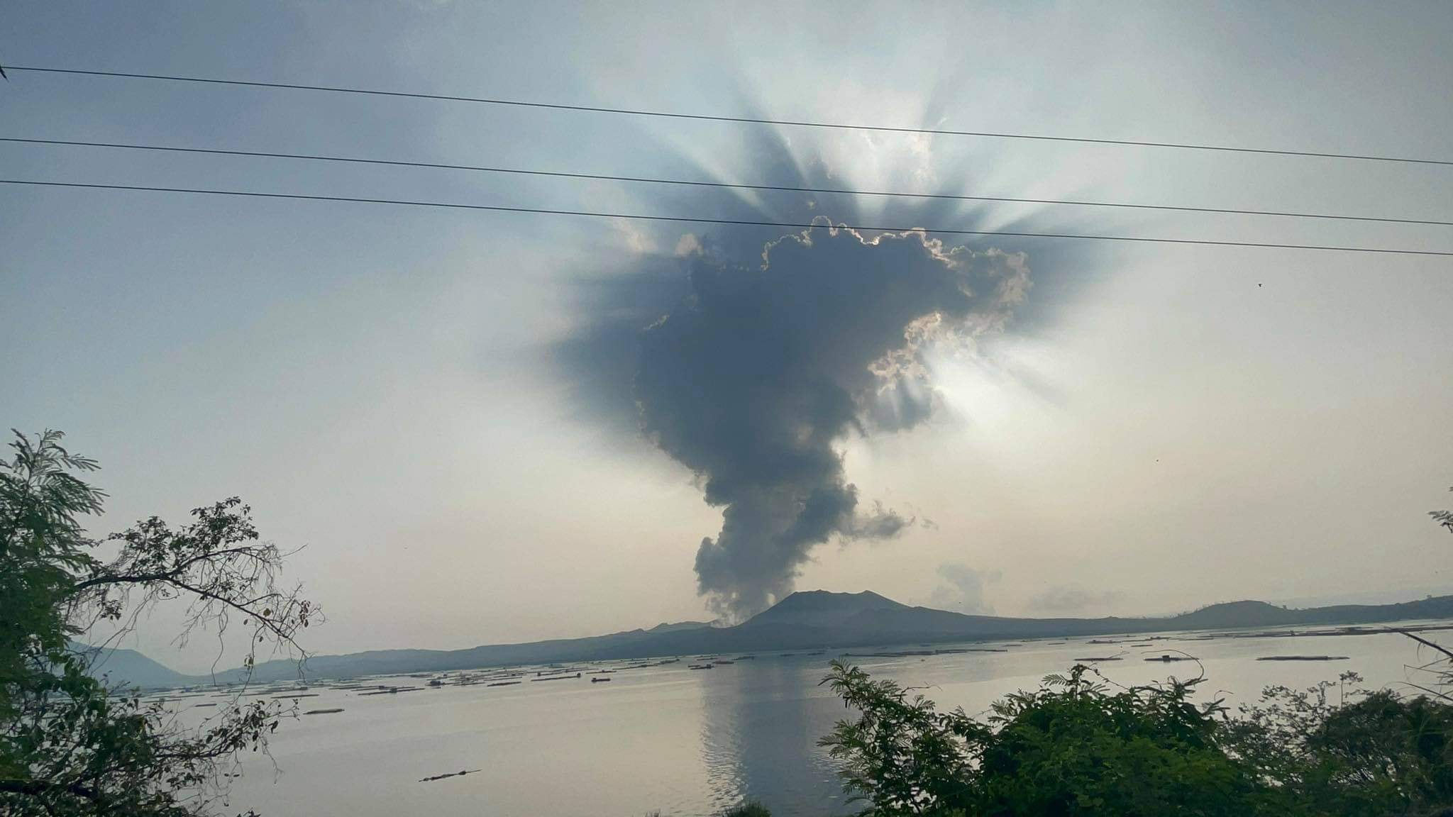
A minor phreatomagmatic event occurred during 10h20-10h22 on 9 April, ejected dark material above the lake’s surface, and produced a plume that rose 300 m. Sulfur dioxide emissions averaged 732 tonnes per day that same day. A one-minute phreatomagmatic event on 10 April ejected dark material above the lake’s surface, and produced a plume that rose 300 m.
The Alert Level remained at 1 (on a scale of 0-5); PHIVOLCS reminded the public that the entire Taal Volcano Island (TVI) was a Permanent Danger Zone (PDZ) and recommended that the Main Crater and areas along the Daang Kastila fissure should remain prohibited. Pilots were warned to avoid flying over TVI.
Sources: Philippine Institute of Volcanology and Seismology (PHIVOLCS) , GVP.
Photo : Seys Marasigan / Seys Channel ( archive).
Costa Rica , Poas :
The Observatorio Vulcanológico y Sismológico de Costa Rica-Universidad Nacional (OVSICORI-UNA) reported an eruption at Poás on 10 April. An eruption signal was recorded on both seismic and acoustic instruments at 2243 that lasted for several minutes. Weather clouds and darkness prevented visual observations. Early on 11 April residents of Grecia reported minor amounts of ashfall on surfaces such as parked cars. The Volcanic Alert Level remained at 2 (the second lowest level on a four-level scale).
The OVSICORI-UNA volcanic monitoring platform detected an eruption on April 10 at 10:44 PM local time in the active crater of Poás Volcano.
● Visual observation of the eruption was impossible due to cloud cover.
● During a field visit, observations revealed the appearance of a new fumarole field near the western rim of the hyperacidic lake, a site previously identified in 2022 following the presence of a low-temperature anomaly (approximately 60°C).
● The erupted material was fine; no bomb impact was observed.
Ash deposits were observed across the entire crater floor and along its western rim.
● The lake level has risen by about 3 meters, mainly due to water displacement caused by the deposition of some of the eruptive material from the new fumarole field.
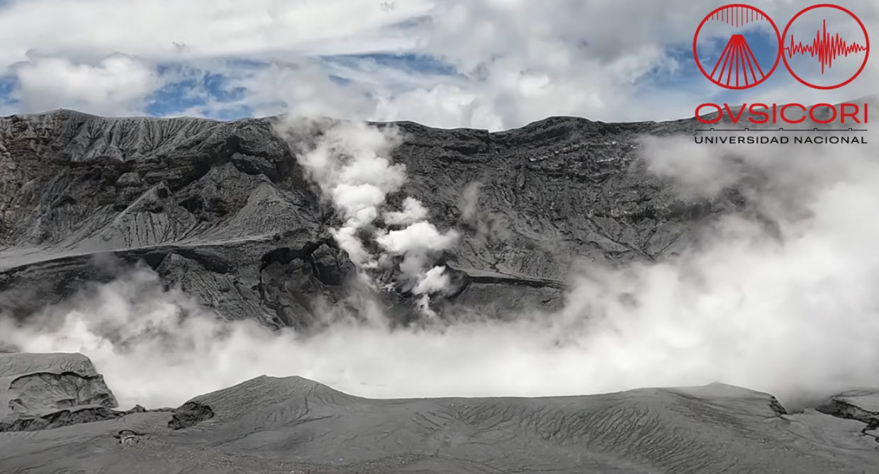
● The seismic signal reveals an eruptive event lasting less than 2 minutes, followed by sustained low-frequency tremor (< 10 Hz), possibly associated with continuous degassing.
● No significant crustal deformation is observed, except for a collapse of the western inner wall to a height of approximately 23 m.
● The SO₂ flux has remained relatively constant.
● The gas composition indicates instability of the hydrothermal-magmatic system prior to the eruption and a weak influence of surface magma since then.
This eruption is attributed to hydrothermal slip/decompression coupling, i.e., a surface process, possibly associated with instability of the hydrothermal-magmatic system, without significant input of deep magma.
Therefore, the activity level of Poás Volcano remains at level 2 (alert) on a scale of 5.
Sources: Observatorio Vulcanologico y Sismologico de Costa Rica-Universidad Nacional (OVSICORI-UNA) , GVP.
Photo : Ovsicori ( capture d’écran ).