April 14 , 2026.
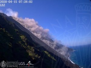
Alaska , Complexe volcanique d’Atka :
AVO/USGS Volcanic Activity Notice
Current Volcano Alert Level: NORMAL
Previous Volcano Alert Level: ADVISORY
Current Aviation Color Code: GREEN
Previous Aviation Color Code: YELLOW
Issued: Monday, April 13, 2026, 3:47 PM AKDT
Source: Alaska Volcano Observatory
Notice Number: 2026/A263
Location: N 52 deg 19 min W 174 deg 8 min
Elevation: 5030 ft (1533 m)
Area: Aleutians
Volcanic Activity Summary:
Seismic activity, sulfur dioxide emissions, and thermal anomalies at Korovin Volcano (located within the Atka Volcanic Complex) have declined over the past couple weeks and are now at background levels. The Aviation Color Code and the Alert Level for the Atka Volcanic Complex are being lowered to GREEN/NORMAL. Small explosive events can occur at Korovin Volcano without significant precursory unrest. Fallout of ash from such events is unlikely to extend beyond the upper flanks of the volcano.
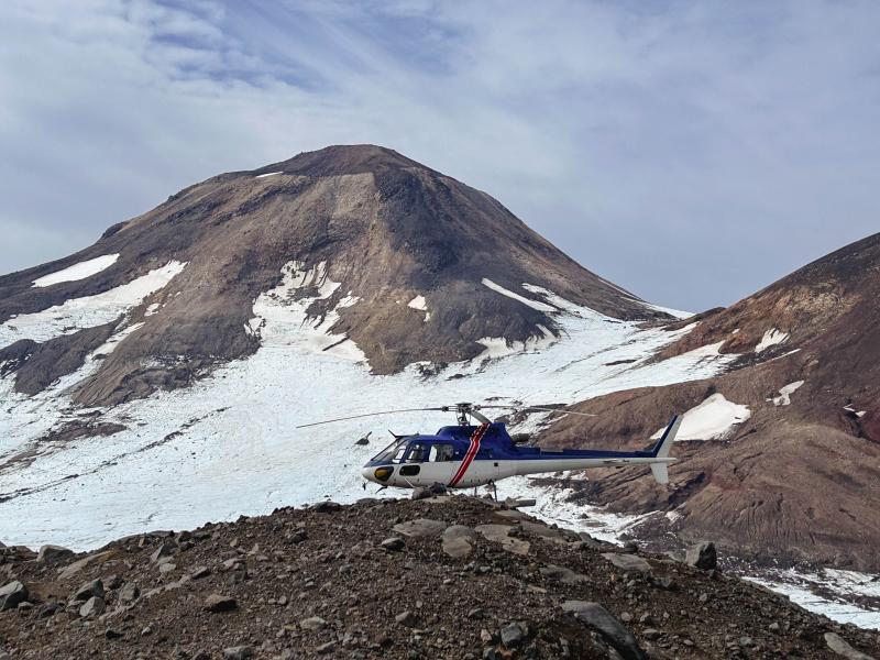
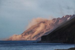
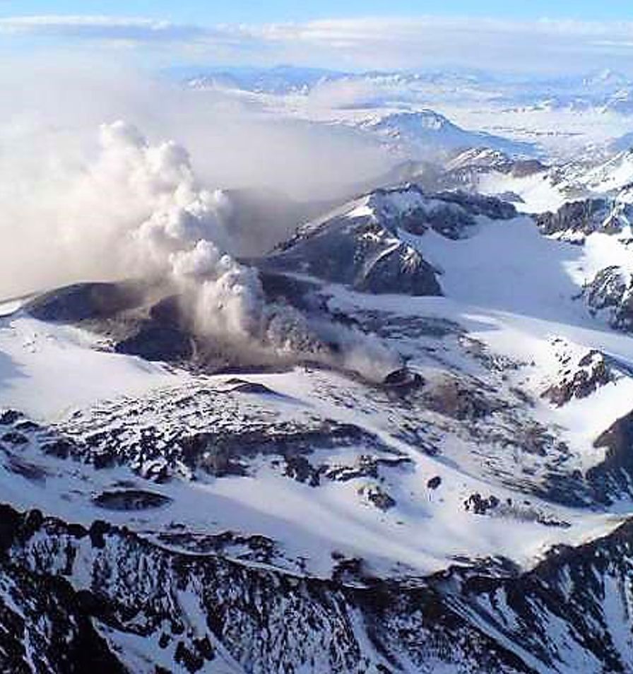
Helicopter sitting on island of lava in Kliuchef’s summit icefield, near station 25AAHD008. West Kliuchef lies beyond. Photo taken during field work at Atka volcanic complex, northern Atka Island.
Remarks:
The Atka volcanic complex forms the northern part of Atka Island, located about 16 km north of the community of Atka and 1,761 km southwest of Anchorage. The Atka volcanic complex includes a possible older caldera and several younger vents, including Korovin Volcano, Mount Kliuchef, and Sarichef Volcano. Korovin Volcano, a 1553-m-high (5030 ft) stratovolcano, has been the site of most historical volcanic activity, and has a small, roiling crater lake that occasionally produces energetic steam emissions. Korovin has erupted several times in the past 200 years, including 1973, 1987, and 1998, and has likely had small ash emissions as recently as 2005. Typical recent Korovin eruptions produce minor amounts of ash and occasional but small lava flows. Reports of the height of the ash plume produced by the 1998 eruption ranged as high as 10,600 m (35,000 feet) above sea level. Mount Kliuchef is composed of a series of five vents aligned northeast–southwest. The two main summit vents of Kliuchef appear relatively young and the easternmost was probably the source of an 1812 eruption that is sometimes attributed to Sarichef.
Source : AVO
Photo : Coombs, Michelle / AVO / USGS.
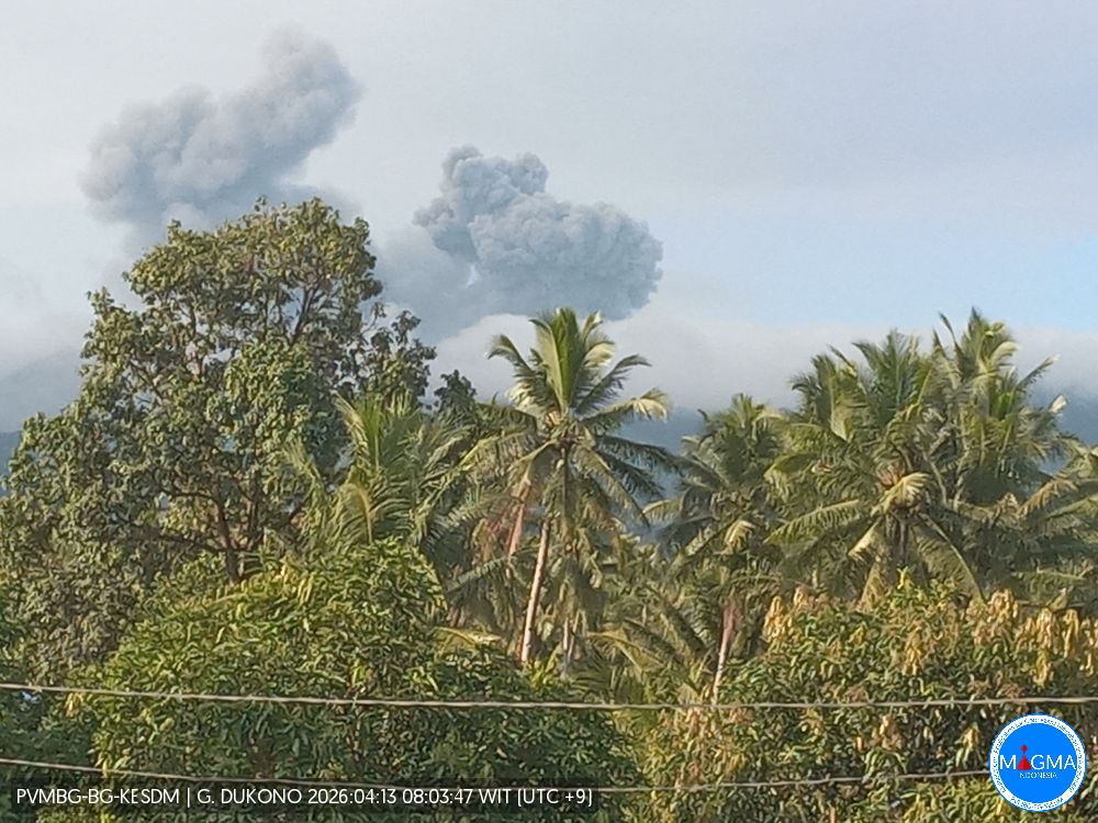
Indonesia , Dukono :
An eruption of Mount Dukono occurred on Tuesday, April 14, 2026, at 12:01 PM WIT, with an observed ash column height of approximately 750 m above the summit (approximately 1837 m above sea level). This ash column, white to gray in color, was highly intense and directed eastward. The eruption was recorded by a seismograph with a maximum amplitude of 25 mm and a duration of 44.25 seconds.
Seismic Observations
103 eruption earthquakes with amplitudes between 7 and 34 mm and durations from 33.72 to 67.88 seconds.
3 distant tectonic earthquakes with amplitudes between 15 and 25 mm and durations from 68.83 to 83.85 seconds.
1 continuous seismic tremor with amplitudes between 1 and 5 mm, predominantly 2 mm.
Recommendations
(1) Communities living near Mount Dukono and visitors/tourists are advised to refrain from any activity, climbing, or approaching the Malupang Warirang crater within a 4 km radius.
(2) Since volcanic ash eruptions are periodic and the dispersion of ash depends on the direction and strength of the wind, making the coverage area unstable, communities living near Mount Dukono are advised to always have masks/face coverings available to protect themselves from the dangers that volcanic ash poses to the respiratory system.
Source et photo : USGS
Chile , Planchón Peteroa :
SPECIAL REPORT ON VOLCANIC ACTIVITY, April 5, 2026
The Argentine Geological and Mining Service (SEGEMAR), through its Argentine Volcanic Monitoring Observatory (OAVV), reports that today, Sunday, April 5, 2026, at 11:54 a.m. local time (2:54 p.m. UTC), the volcanic monitoring stations located near the Planchón-Peteroa volcanic complex recorded a volcano-tectonic (VT) seismic event associated with rock fracturing within the volcanic system.
Information on the highest-energy event:
Time of origin: 11:54 a.m. local time (2:54 p.m. UTC)
Latitude: -35.1987°
Longitude: -70.5382°
Depth: 6.6 km
Local magnitude: 3.1 (ML)
OBSERVATIONS:
At the time of publication of this report, low-energy VT-type seismic activity continues to be recorded. No other changes have been observed in the monitoring parameters of this volcanic complex.
CONCLUSIONS:
The technical alert level remains in effect, and monitoring of the volcano continues in constant communication with the Southern Andes Volcanological Observatory (OVDAS) of Chile, as well as with local, provincial, and national civil protection authorities, within the framework of the National Integrated Risk Management System (SINAGIR) and through the Federal Emergency Management Agency (AFE).
Source et photo : Segemar .
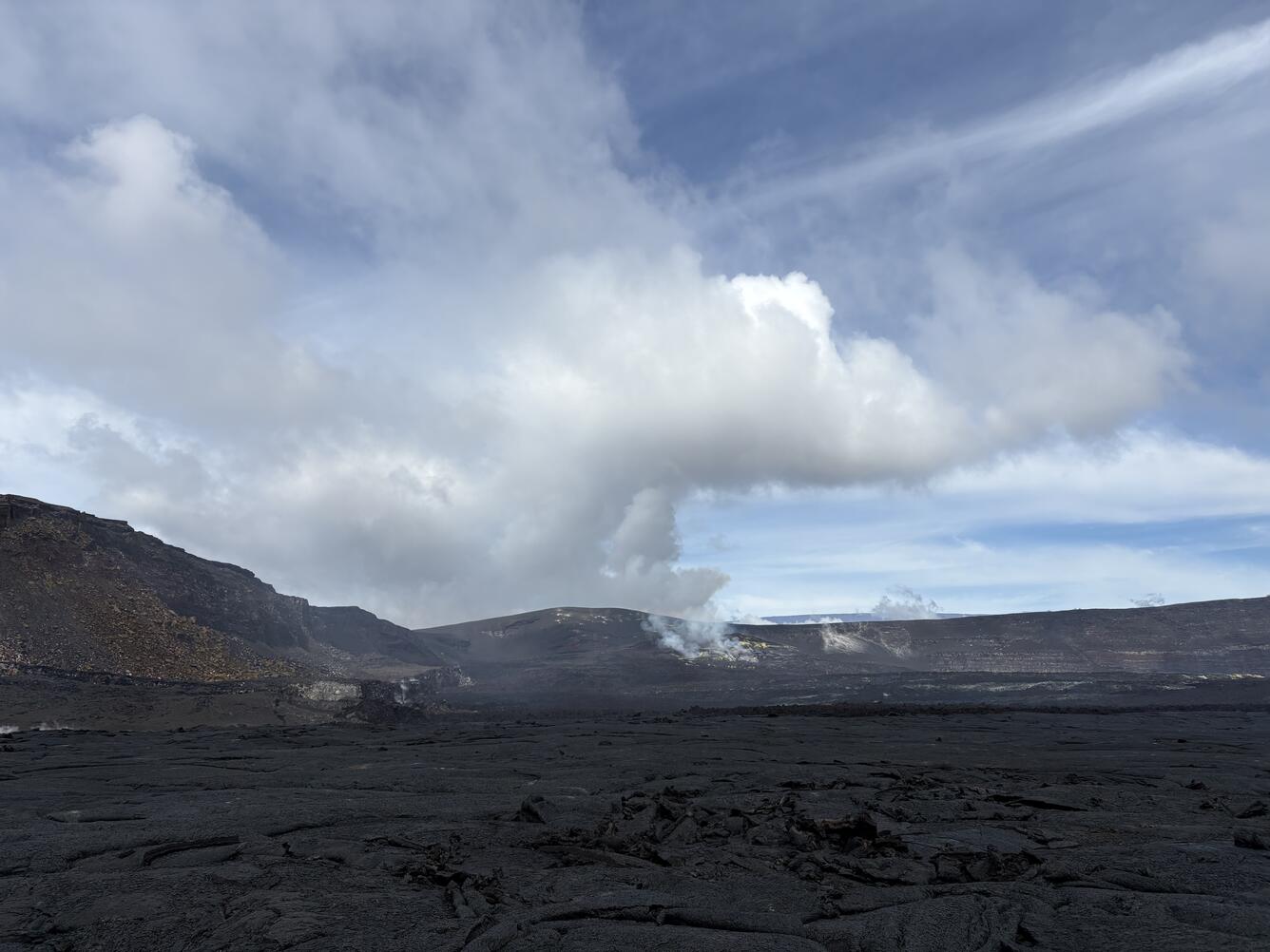
Hawaii , Kilauea :
HAWAIIAN VOLCANO OBSERVATORY DAILY UPDATE , U.S. Geological Survey
Monday, April 13, 2026, 8:33 AM HST (Monday, April 13, 2026, 18:33 UTC)
19°25’16 » N 155°17’13 » W,
Summit Elevation 4091 ft (1247 m)
Current Volcano Alert Level: ADVISORY
Current Aviation Color Code: YELLOW
Overview:
The Halemaʻumaʻu eruption of Kīlauea is paused. Glow from the eruptive vents continued over the past day, along with incandescence on the crater floor as episode 44 lava flows cool and solidify. Many Kīlauea monitoring data streams are presently offline due to an outage of HVO’s radio telemetry network, but the remaining operational stations are sufficient to detect any major changes in the volcanic system; none are noted at this time.
No significant activity has been noted along Kīlauea’s East Rift Zone or Southwest Rift Zone.
NOTES:
At the time episode 44 ended, Kīlauea’s Volcano Alert Level was dropped to ADVISORY and its Aviation Color Code was dropped to YELLOW. This is a new procedure that has been adopted due to the lower ground and aviation hazards during eruptive pauses, between episodes.
Summit Observations:
Overnight, glow was consistently visible at the Halemaʻumaʻu south vent, while none was apparent at the north vent. Episode 44 lava flows on the crater floor retain spots of incandescence as they cool and solidify, which will likely continue for several more days. Lava fountaining episode 44 occurred on April 9.
No significant seismicity has been detected in the vicinity of Kīlauea summit over the past day. HVO’s tiltmeters are presently offline due to the radio telemetry network outage.
With the eruption now paused, the sulfur dioxide (SO2) emission rate from Halemaʻumaʻu is likely now varying within a typical range of 1,000 to 5,000 tonnes per day. Winds near the eruptive vents were steady out of southwest yesterday and overnight.
Rift Zone Observations:
Rates of seismicity remain low in the East Rift Zone and Southwest Rift Zone. A M3.5 earthquake occurred yesterday at 10:44 a.m. HST, 5.5 kilometers (3.5 miles) beneath the south flank of Kīlauea, and it was reported felt by 20 Island of Hawaiʻi residents. However, this earthquake had no apparent effect on volcanic activity.
Source : HVO.
Photo : USGS / D. Downs.
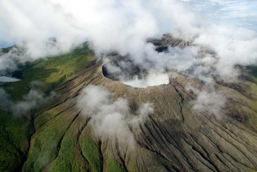
Costa Rica , Rincon de la Vieja :
Latitude: 10.83°N
Longitude: 85.34°W
Altitude: 1916 m
Current Activity Level: Alert.
Six small eruptions were recorded this week. None generated lahars. The most energetic (acoustically) eruption occurred on April 9 at 5:05 PM.
Since April 1, sequences of banded tremors have been recorded, with variations in amplitude, duration, and interval between occurrences. After the eruption on April 9, the banded tremors ceased, and a weak tremor with a frequency of 3.8 Hz was observed.
Long-period, tornillo-type events of stable amplitude continue to occur. The dominant frequency of tornillo tremors continues to decrease this week. Two distal and two proximal volcano-tectonic earthquakes were recorded this week. The geodetic network shows no significant deformation, except for a slight contraction at the base of the volcano. This week, DOAS stations recorded an average SO₂ flux of 175 ± 156 t/d, similar to that of the previous week (175 ± 156 t/d). The last detection of SO₂ in the atmosphere by the SENTINEL satellite, emitted by the Rincón de la Vieja volcano, was on September 7, 2025.
Source et photo : Ovsicori