July 1 , 2026.
Italy / Sicily , Etna :
WEEKLY BULLETIN, June 22, 2026 – June 28, 2026 (Date of issue: June 30, 2026)
SUMMARY OF ACTIVITY STATUS
Based on monitoring data, the observations are as follows:
1) VOLCANOLOGICAL OBSERVATIONS: Effusive activity in the upper part of the Valle del Bove (Valle del Leone); modest, intermittent Strombolian activity and weak ash emissions at the Voragine crater; intra-crater explosive activity at the North-East crater; light, episodic ash emissions at the Bocca Nuova crater.
2) SEISMOLOGY: Fracture-related seismic activity at a moderate level. Average volcanic tremor amplitude within usual ranges, with a steady increase since June 3.
3) INFRASOUND: Infrasonic activity varying between low and high levels.
4) GROUND DEFORMATION: Over the past month, Etna’s ground deformation monitoring networks showed only slight variations. Specifically, in the two days prior to the start of the current eruption, modest variations were observed in the signal from the M. Ruvolo extensometer; overall, the GNSS signal indicates a modest inflation trend.
5) GEOCHEMISTRY: SO2 flux: high values during the first half of June, followed by a drop to average levels.
Soil CO2 flux (Etnagas): within usual ranges.
Partial pressure of dissolved CO2 in groundwater (EtnaAcque network): no update.
Helium (He) isotope ratio at peripheral sites: high values (latest data from June 15, 2026).
6) SATELLITE OBSERVATIONS: Over the past week, satellite-observed thermal activity in the summit area remained generally low to moderate, with elevated levels associated with the effusive activity that began on June 26, 2026, and is still ongoing.
VOLCANOLOGICAL OBSERVATIONS
During June, volcanic activity at Mount Etna was monitored through the analysis of images from INGV–Osservatorio Etneo (INGV-OE) surveillance cameras and direct field observations by INGV-OE personnel. Overall, the observation period was characterized by explosive activity at the Voragine crater, intra-crater activity at the Northeast Crater (CNE), and ash emissions at the Bocca Nuova crater (BN)—referred to as VOR, CNE, and BN, respectively—as well as effusive activity in the upper Valle del Bove sector starting on June 26 (Valle del Leone).
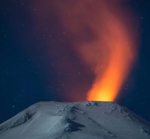
In particular, intra-crater explosive activity at the CNE—which began in late May—continued throughout the month; this activity generated intense, continuous degassing, nocturnal glows, and sporadic ejections of incandescent material that fell back into the crater. The BN crater saw a slight intensification of activity at the BN-1 vent between June 14 and 15, characterized by weak, episodic ash emissions; these dispersed rapidly over the summit area and were not associated with thermal anomalies. No further emissions were observed after June 22.
Starting on the morning of June 10, sporadic grey-brown ash emissions were also detected from the depression located on the upper eastern flank of the Voragine crater (the vent formed on December 27, 2025). This activity appears to have been preceded, the previous day (June 9, 2026), by a minor collapse affecting the depression itself. On June 21, 2026, drone-based field surveys conducted by INGV personnel revealed that the fracture network along the eastern flank of the Voragine—fractures that had appeared between August 2025 and January 2026—had propagated toward the northeast and southeast. Morpho-structural analysis based on these surveys enabled the creation of a map of surface discontinuities; this map highlights the presence of detachment niches (comprising both recent fractures and those already present in December 2025), collapse craters, and gravity-driven accumulations in the east-southeast sector of the Voragine. The area of the main niche is estimated at approximately 82,250 m², with a vertical displacement of about 3 m. A comparison of digital terrain models (DTMs) from June 22, 2026, and June 4, 2025, shows that the primary volume loss is concentrated in the southeast sector of the depression, resulting from small-scale, gravity-driven surficial landslides.
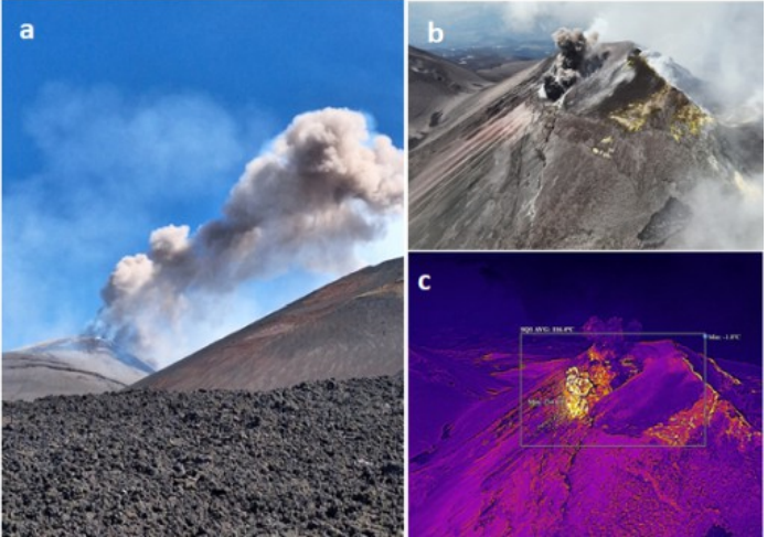
Ash emission from the active vent located on the upper eastern flank of the Voragine crater (15 June 2016); (b) and (c) visible and thermal infrared images of the Voragine crater, acquired by drone on 22 June 2016, showing part of the fracture network along the crater’s eastern slope.
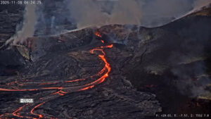
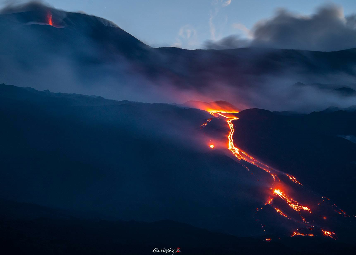
On the morning of 26 June 2016, the northeastern sector of the fracture system was observed to have extended further downslope, near the cones formed during the July–August 2014 eruption. At noon that same day, INGV field personnel observed a lava flow emerging from the lower end of the fracture system at an elevation of approximately 3030 m; this flow extended into the upper sector of the Valle del Leone (the upper part of the Valle del Bove) at an elevation of approximately 3000 m. Furthermore, during the following night, surveillance camera images revealed weak, irregular Strombolian activity originating from the depression on the upper eastern flank of the Voragine. On 27 June, field surveys and drone imagery obtained during an inspection by INGV personnel showed that effusive activity at the vent located at 3030 m was continuing, feeding a lava flow approximately 630 m long; in its distal section, the flow split into two main branches, with the furthest-advancing front reaching an elevation of approximately 2780 m. The area covered was approximately 0.18 × 10⁵ m², and the volume was approximately 0.45 × 10⁵ m³ (volume uncertainty: 40%). During the inspection, no explosive activity was observed at the Voragine; only intense degassing was noted.
A further field inspection by INGV-OE personnel on the morning of June 29 revealed ongoing effusive activity, with the flow front located at an estimated elevation of 2,750 to 2,700 m above sea level. No explosive activity was observed at the Voragine during the inspection; however, starting at 19:50 UTC that evening, surveillance cameras recorded intermittent Strombolian activity of varying intensity at the depression on the upper eastern flank of the Voragine.
Source : INGV.
Photos : Giovinsky Aetnensis , INGV.
Italy , Stromboli :
WEEKLY BULLETIN, June 22, 2026 – June 28, 2026 (Date of issue: June 30, 2026)
SUMMARY OF ACTIVITY STATUS
Based on monitoring data, the observations are as follows:
1) VOLCANOLOGICAL OBSERVATIONS: Ordinary Strombolian eruptive activity across both crater zones, accompanied by lava spattering of varying intensity in the North Crater zone. The overall frequency of explosive activity—encompassing both the North Crater zone and the Central-South Crater zone—is at a medium level, with moderate explosion intensity in both zones.
2) SEISMOLOGY: Monitored seismic parameters show no significant variations.
3) GROUND DEFORMATION: No significant variations detected in the GNSS network time series.
4) GEOCHEMISTRY: SO2 flux is at a low level.
Soil CO2 flux in the Pizzo area (STR02): no recent data available.
C/S ratio in the plume: values remained in the medium-high range over the past week.
Helium isotope ratio (R/Ra): remains close to the threshold for very high values (R/Ra = 4.48).
Soil CO2 flux in the San Bartolo area: remains at very high levels.
5) SATELLITE OBSERVATIONS: Satellite-observed thermal activity in the summit area remained generally low, with a few isolated anomalies of moderate intensity.

VOLCANOLOGICAL OBSERVATIONS
Observations of explosive activity captured by surveillance cameras
During the observation period, explosions in the North Crater zone (Zone N) were fed by five vents: two active in the N1 sector and three in the N2 sector. These five vents primarily produced coarse material (bombs and lapilli). In the Central-South Crater zone (Zone CS), two vents were observed producing explosive activity involving emissions of fine material mixed with coarse material. Throughout the week, the total hourly explosion frequency remained at a moderate level. Specifically, the average explosion frequency for the North zone was moderate, and the intensity remained predominantly low to moderate; in the Central-South zone, the average explosion frequency was moderate, and the intensity of explosive activity was generally moderate.
Source : INGV.
Photo : Stromboli stati d’animo / Sebastiano Cannavo
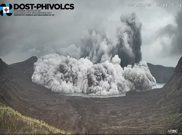
Philippines , Taal :
A minor phreatomagmatic eruption occurred on June 30, 2026, at 14:34, in the main crater of Taal Volcano. Lasting four and a half minutes, the event was assessed through seismic, infrasonic, and visual observations.
Parameters:
2 phreatomagmatic eruption episodes (duration: 4 minutes)
Seismicity
19 volcano-tectonic earthquakes, including 5 volcanic tremors (duration: 2 to 10 minutes)
Main crater lake acidity
0.48 (February 10, 2026)
Main crater lake temperature
63.1°C (February 10, 2026)
Sulfur dioxide (SO2) flux
881 tonnes/day (June 25, 2026)
Plume
Height of 1,200 meters; moderate emission; drifting towards the south-southeast and southwest
Ground deformation
Short-term inflation of Taal Volcano Island
RECOMMENDATION / COMMENT
Access to Taal Volcano Island (Permanent Danger Zone or PDZ)—specifically the main crater and the Daang Kastila fissures—as well as any occupation of or boating on Taal Lake
Overflight of the volcano by any aircraft
Potential risks:
hydrothermal (phreatic) or gas-driven explosions
volcanic earthquakes
minor ashfall
accumulations or lethal emissions of volcanic gases
Source et photo : Phivolcs.
Papua New Guinea , Bagana :
Activity at the Bougainville volcano is intensifying, while the Titan Ridge submarine volcano is quieting down.
Explosive activity at Mount Bagana, on Bougainville Island, has intensified in recent days.
The Rabaul Volcanological Observatory (Papua New Guinea) has issued a Level 1 alert for Bagana due to the most significant surge in activity recorded in two years. Steve Saunders, the observatory’s principal geodesist, noted that while the volcano had shown steady activity for several years, this activity intensified last week. « There was a major eruption; it essentially involved a dome collapse along the eastern flank. It was very spectacular, but since it occurred in uninhabited areas, it did not pose a major problem. »
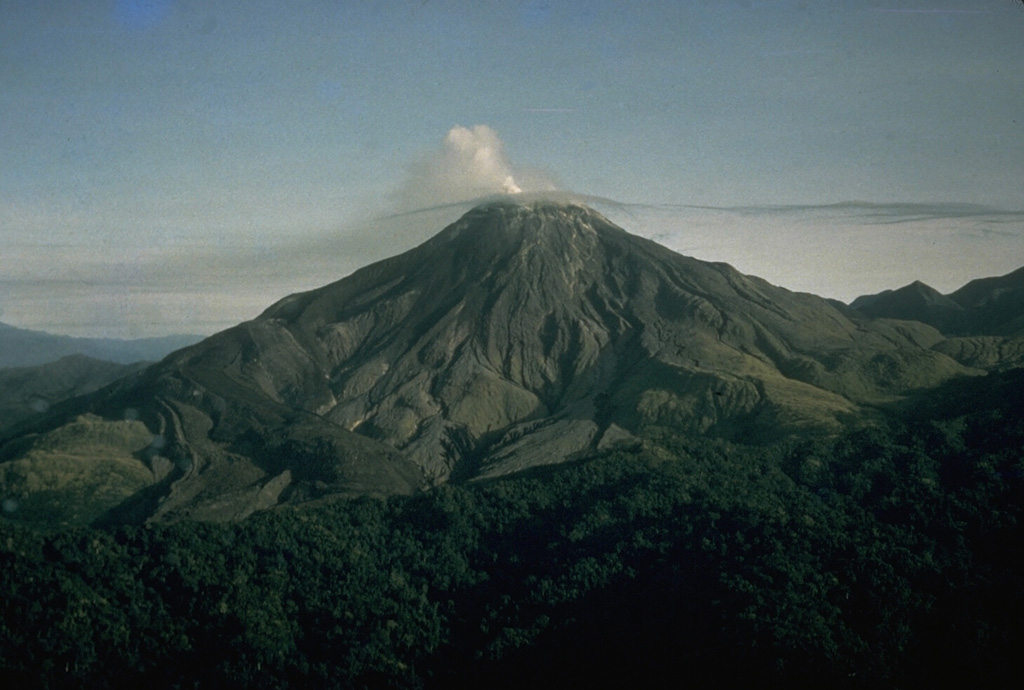
Noting ongoing lava activity at the summit, Mr. Saunders mentioned « a red glow and rockfalls down the slopes every few weeks. » « There was some dust fallout downwind, and so on, but the situation appeared more serious than it actually was. » Social media reports indicated dust issues affecting crops further south in Torokina, on the east coast of Bougainville. Papua New Guinea’s National Information Centre stated that the Disaster Management Office (under the Department of Community and District Affairs) was in contact with Torokina and other affected areas and was monitoring the situation.
The Pumice Problem
Meanwhile, in another part of Papua New Guinea’s islands region—Manus Province—Mr. Saunders reported that large rafts of pumice, originating from an active submarine volcano in the Bismarck Sea, had begun to disperse. Since May, pumice produced by the « Titan Ridge » volcano had been carried by tides and currents toward the southern coast of Manus Island, affecting marine life and navigation. However, Mr. Saunders noted that the volcano’s pumice production had decreased as activity subsided over the past two weeks, and that the pumice rafts around Manus Island had largely been dispersed by currents and winds. Nevertheless, Manus residents told RNZ Pacific that the pumice remained a problem and was increasingly affecting the province’s small outlying islands as well.
Source : rnz.co. NZ .
Photo : CD. Branch, 1964 (avec l’aimable autorisation de Ben Talai, Observatoire du volcan Rabaul) / GVP .
Indonesia , Kelimutu :
Temperature rise at the Kolorongo spring and in the crater lake waters of Mount Kelimutu, East Nusa Tenggara (June 30, 2026).
Temperature measurements and visual observations conducted on June 30, 2026, at Mount Kelimutu—located in the Ende Regency, East Nusa Tenggara province—indicate a significant rise in the temperature of Crater II (Tiwu Ko’ofai Nuwamuri) compared to previous readings. The temperature of Crater II was 28.4°C on June 9, 2026, and rose to 31.3°C on June 16, 2026. By the time of the June 30, 2026 measurement, it had increased further to reach 35°C. Visually, the color of the lake water shifted from bluish-green to light green. However, this temperature rise was not accompanied by an increase in seismic activity or a rise in the height of plumes emanating from the surface of the Crater II lake.
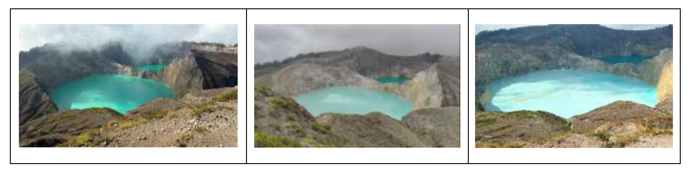
Mount Kelimutu features three crater lakes: Crater I (Tiwu Ata Polo), Crater II (Tiwu Ko’ofai Nuwamuri), and Crater III (Tiwu Ata Bupu). Despite rising water temperatures in Crater II and at the Kolorongo spring, no significant changes in seismic activity have been observed at Mount Kelimutu. Currently, the volcano remains at Alert Level I (NORMAL). Mount Kelimutu is a highly popular volcanic tourist destination that attracts a large number of visitors.
In light of this data, local residents and visitors are advised to avoid approaching the crater rims—particularly that of Crater II—and to remain vigilant regarding the potential risk of phreatic eruptions. Local authorities and the Regional Disaster Management Agency (BPBD) are urged to maintain coordination with the Mount Kelimutu observation post, located in the hamlet of Kolorongo (Waturaka Village, Ende Regency, East Nusa Tenggara Province), as well as with the Center for Volcanology and Geological Hazard Mitigation in Bandung.
Source et photo : PVMBG.