June 27 , 2026.
Italy / Sicily , Etna :
Statement on Mount Etna activity, June 26, 2026, 13:16 (11:16 UTC)
The National Institute of Geophysics and Volcanology (INGV) – Osservatorio Etneo – reports the onset of effusive activity in the upper part of the Valle del Leone (upper Valle del Bove), at an elevation of approximately 3,000 meters above sea level, as detected during field observations by INGV personnel. This activity is generating a small lava flow currently being fed at a low discharge rate. It is also noted that weak, irregular Strombolian explosive activity occurred at the Voragine crater during the night.
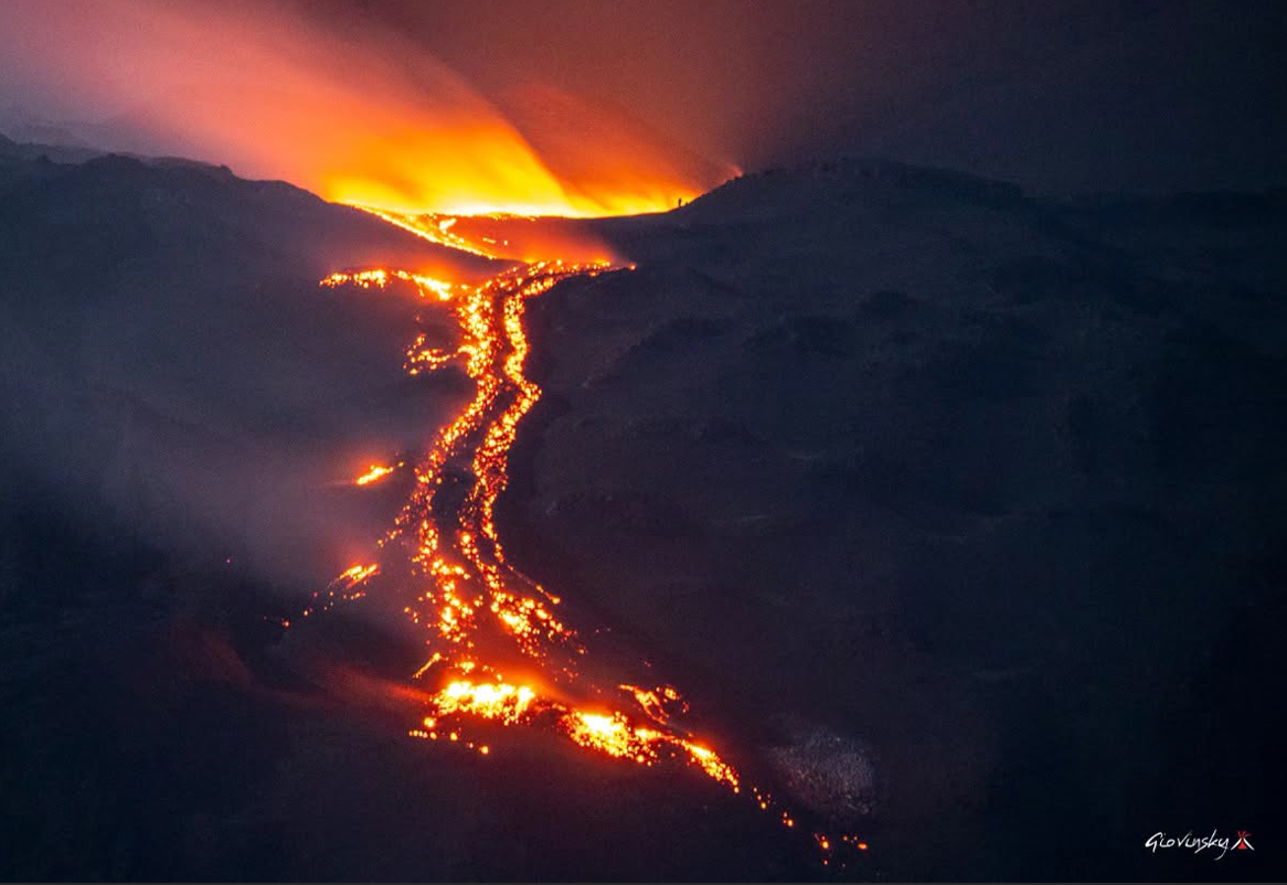
Seismically, a steady increase in volcanic tremor has been observed over the past few days; the sources are currently located beneath the Voragine crater, at an elevation of approximately 2,900 meters above sea level.
Infrasonic activity is centered at the Northeast Crater, with the amplitude and number of events remaining at moderate levels.
No significant changes have been detected in the time-series data from ground deformation monitoring stations.
Further updates will be provided in due course.
Civil Protection: Yellow alert for Mount Etna. Update: June 26, 7:30 PM
The Civil Protection Department has raised the alert level for Mount Etna from green to yellow and has initiated the « pre-alert » operational phase. It has instructed local civil protection agencies to implement appropriate operational phases and risk mitigation measures at the local level, particularly regarding the potential presence of hikers at high altitudes.
Source : INGV.
Photo : Giovinsky Aetnensis
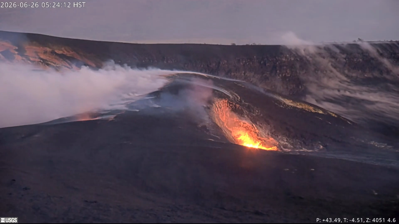
Hawaii , Kilauea :
HVO/USGS Volcanic Activity Notice
Current Volcano Alert Level: WATCH
Previous Volcano Alert Level: ADVISORY
Current Aviation Color Code: ORANGE
Previous Aviation Color Code: YELLOW
Issued: Friday, June 26, 2026, 9:14 AM HST
Source: Hawaiian Volcano Observatory
Notice Number: 2026/H303
Location: N 19 deg 25 min W 155 deg 17 min
Elevation: 4091 ft (1247 m)
Area: Hawaii
Summary:
Precursory low-level eruptive activity before episode 50 of the ongoing Halemaʻumaʻu eruption increased around 8:50 a.m. HST on June 26.
Volcanic Activity:
Precursory low-level activity for episode 50 of the ongoing Halemaʻumaʻu eruption at the summit of Kīlauea increased around 8:50 a.m. HST on June 26 with a small lava overflow from the north vent along with increasing levels of spattering and gas jetting. Accordingly, HVO is raising the Alert Level for Kīlauea from ADVISORY to WATCH and the Aviation Color Code from YELLOW to ORANGE. This low-level precursory activity can continue for hours to days before the lava fountaining episode beings. Lava fountain episode 50 is forecast to start today (most likely) or tomorrow. Another VAN will be published when lava fountaining episode 50 begins.
Surface winds below the inversion level (about 8,000 feet or 2,400 meters above sea level) are forecast to be moderate to strong tradewinds out of the northeast, which will move the lower part of the plume to the southwest. Above the inversion layer, light winds from the south are forecast up to 16,000 feet (5,000 meters) where they will turn to the southwest and strengthen. Higher level winds could push parts of the plume to the north over surrounding communities.
Source et photo : HVO.
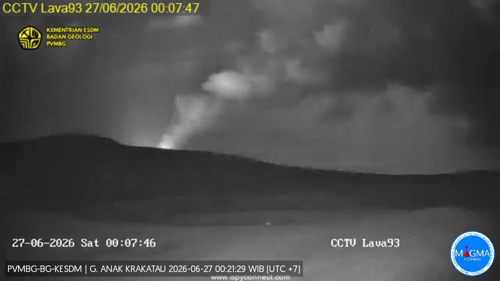
Indonesia , Anak Krakatau :
Volcanic activity at Mount Anak Krakatau, in the Sunda Strait, intensified during the observation period on June 24, 2026.
The Center for Volcanology and Geological Hazard Mitigation (PVMBG) recorded dozens of volcanic earthquakes within a 24-hour period, although the volcano’s alert level remains at Level II (Vigilance/Waspada). According to the official PVMBG report, the recorded seismic activity included 41 emission earthquakes, 21 low-frequency earthquakes, 47 hybrid earthquakes, and one distant tectonic earthquake. In addition to the increase in seismic activity, visual observations revealed white smoke emissions rising from the active crater to heights ranging from 10 to 200 meters above the summit.
Overnight, observers also reported a glow emanating from the active crater area of Anak Krakatau. Rioboniek Situmorang, author of the Mount Anak Krakatau activity report, confirmed that the volcano’s alert level remains at Level II (Waspada). Consequently, the public is strongly urged to continue adhering to established guidelines.
« The public, visitors, tourists, and climbers are prohibited from approaching Mount Anak Krakatau or conducting activities within a 2-kilometer radius of the active crater, » wrote Rioboniek in the official PVMBG report cited this Thursday (June 25, 2026). The PVMBG explained that, despite the increase in volcanic activity, the situation at Mount Anak Krakatau has not undergone significant changes warranting an increase in the alert level.
Seismic observations
121 emission earthquakes with amplitudes of 2 to 47 mm and durations of 18 to 137 seconds.
6 low-frequency earthquakes with amplitudes of 4 to 5 mm and durations of 5 to 15 seconds.
72 hybrid/multiphase earthquakes with amplitudes of 2 to 22 mm and durations of 4 to 17 seconds.
2 distant tectonic earthquakes with amplitudes of 9 to 13 mm and durations of 242 to 512 seconds.
1 episode of continuous tremor with an amplitude of 0.5 to 14 mm (dominant amplitude of 2 mm).
Recommendations
The public, visitors, tourists, and hikers must not approach Mount Anak Krakatau or engage in activities within a 2 km radius of the active crater.
Sources : Saibumi , PVMBG.
Photo : PVMBG.
Colombia , Nevado del Ruiz :
Manizales, June 23, 2026, 2:40 PM
Based on monitoring of the Nevado del Ruiz volcano’s activity, the Colombian Geological Service (SGC)—an agency attached to the Ministry of Mines and Energy—reports the following information:
During the week of June 16 to 22, 2026, the volcano continued to exhibit unstable behavior.
Compared to the previous week, the main variations in monitored parameters were as follows:
– Seismic activity associated with rock-fracturing processes within the volcanic edifice remained at similar levels regarding the number of recorded earthquakes, while the released seismic energy decreased. Seismic events were located primarily on the north-northeast, west-southwest, and northeast flanks—at distances of less than 8 km from the Arenas crater—as well as within the crater itself. Relative to the volcano’s summit, earthquake depths ranged from less than 1 km to 2 km beneath the Arenas crater, and from 2 km to 9 km in other sectors.
The maximum magnitude was 1.5, recorded during earthquakes on June 17 at 1:41 AM and June 23 at 1:05 AM. Both events were located between 2 km and 4 km from the crater—to the
north-northeast and northeast, respectively—at depths ranging from 3 km to 4 km.

– Seismicity associated with fluid dynamics within the volcanic conduits showed a decrease in both the number of recorded earthquakes and the seismic energy released. These seismic signals corresponded to short-duration, low-energy events. Similarly, no long-duration seismic signals were detected this week, and no pulsatile ash emissions or changes in the apparent temperature of the gas plume were confirmed.
– Emissions of water vapor and volcanic gases—primarily sulfur dioxide (SO₂)—continued into the atmosphere via the Arenas crater. The estimated SO₂ flux associated with degassing processes remained variable, with levels similar to those recorded the previous week. Additionally, satellite data platforms indicated low levels of SO₂ output.
– The vertical height of the gas and water vapor plume remained generally below 300 m above the volcano’s summit, reaching a maximum of 400 m on the afternoon of June 19. The plume’s dispersion direction was variable, trending mainly toward the volcano’s northwest, west-northwest, and west-southwest flanks.
– Satellite monitoring of thermal anomalies at the bottom of the Arenas crater remained limited due to persistent cloud cover in the area.
Source et photo : SGC.
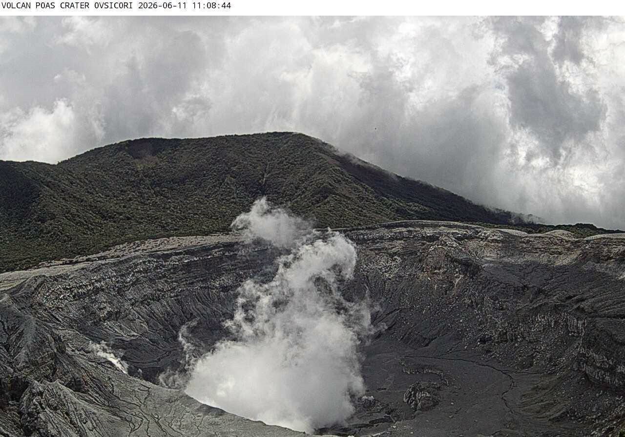
Costa Rica , Poas :
OVSICORI-UNA Weekly Volcanic Monitoring Bulletin, June 26, 2026
Latitude: 10.20°N;
Longitude: 84.23°W;
Elevation: 2,687 m above sea level.
Current activity level: Advisory
An eruption was recorded this week on Saturday, June 20, at 16:47. Visual observation was not possible due to cloud cover. The acoustic magnitude was 2.3, which is relatively low. Tremor amplitude, which had increased the previous week, remained at high levels with variable spectral content, including episodes of monochromatic tremor. The number of long-period events continues to decrease, reaching zero events per day this week. Two proximal volcano-tectonic earthquakes were recorded this week on the southwest flank, with local magnitudes of 2.6 and 1.9; both occurred on June 23. An increase in the number of high-frequency events is being recorded at stations located near the crater.
The geodetic network detected no clear deformation pattern, except for slight contraction around the crater. SO2/CO2 values similar to those of the previous week were recorded, and the H2S/SO2 ratio remains below 0.1. NOVAC stations recorded 241 ± 58 tonnes of SO2 per day, a flux higher than that of the previous week (154 ± 72 t/d). The SENTINEL satellite detected the SO2 plume on several occasions, with a peak value exceeding 47 tonnes of SO2 on June 21. The level of the hyperacidic lake continues to rise slowly. The lake temperature remains very high (approximately 74°C).
Source et photo : Ovsicori