June 17 , 2026.
Italy , Stromboli :
WEEKLY BULLETIN, from June 8, 2026 to June 14, 2026. (Date of issue: June 16, 2026.)
1. ACTIVITY SUMMARY
In light of the monitoring data, the following points should be noted:
1) VOLCANOLOGICAL OBSERVATIONS:
Ordinary Strombolian-type eruptive activity in both crater areas, associated with ejections of varying intensity in the North crater area. Major explosion on June 12 in the North crater area. Frequency of total explosive activity, including the North and Central-South crater areas, of a medium level and of medium to high intensity in the North crater area and medium in the Central-South area.
2) SEISMOLOGY:
The monitored seismic parameters showed no significant changes, with the exception of the strongest explosion recorded at 05:12 UTC on June 12.
3) GROUND DEFORMATION:
The GNSS network did not measure any significant changes during the week.
4) GEOCHEMISTRY:
SO₂ flux at an average level.
CO₂ flux from the ground in the Pizzo area (STR02): remains at average values.
C/S ratio in the plume: over the past week, it has remained at average to high values.
The helium isotope ratio (R/Ra) remains close to the very high threshold (R/Ra = 4.47).
CO₂ flux from the ground in the San Bartolo area: remains at high to very high levels.
5) SATELLITE OBSERVATIONS:
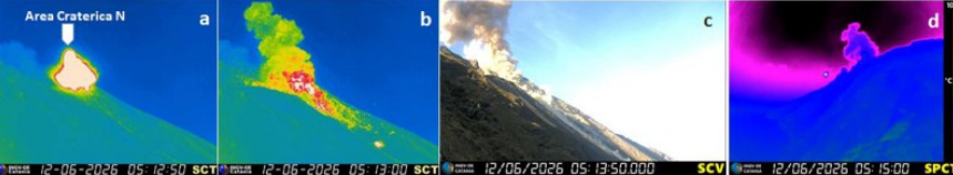
Thermal activity observed by satellite in the summit area was generally of low intensity, with some moderate anomalies corresponding to the largest explosion that occurred on June 12, 2026.
VOLCANOLOGICAL OBSERVATIONS
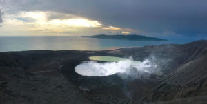
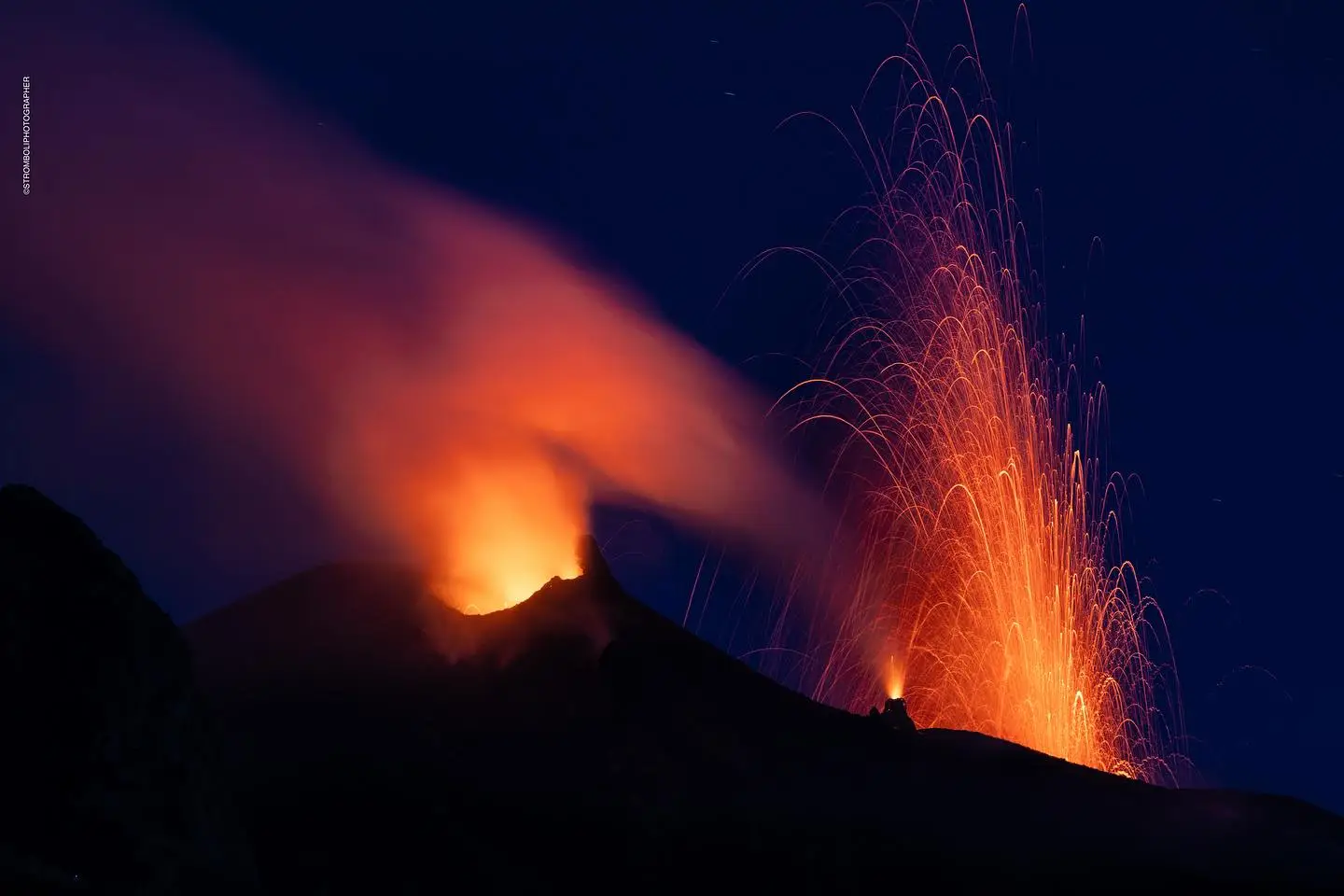
During the week of observation, Stromboli’s eruptive activity was characterized by the analysis of images recorded by the INGV-OE surveillance cameras located at an altitude of 190 m and at Punta dei Corvi (SCT-SCV and SPCT, respectively). Explosive activity was primarily produced by five eruptive vents located in the North Crater area (N zone) and by at least two vents located in the Central-South zone.
Observations of explosive activity captured by surveillance cameras
The average daily hourly frequency of explosions remained at a moderate level, with a slight increase on June 14. The explosions in the North zone were fueled by five active vents, two in sector N1 and three in sector N2, which produced mainly coarse material (bombs and lapilli). The average frequency of explosions in the northern zone was moderate, and the intensity remained moderate to high, increasing to high levels on June 12. In the central-southern zone, two explosive vents were observed, producing fine material mixed with coarse material; the average frequency of explosions was low, with the intensity remaining generally moderate to high on June 15.
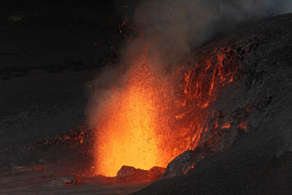
Major Explosion of June 12, 2026
On June 12, the Northern Zone experienced a major event, including a main explosion at 05:12 UTC, followed by at least three smaller explosions. The eruptive cloud dispersed into the atmosphere within minutes. The eruptive products, primarily coarse (lapilli, bombs, and lava fragments), exploded mainly in the upper sector of the Sciara del Fuoco. Some of the fallout was also channeled into the canyon, traveling along the Sciara del Fuoco, but did not reach the coastline. The deposits in the proximal zone gradually cooled, fueling a thermal anomaly that persisted for several hours.
Source : INGV.
Photo : Stromboli stati d’animo / Sebastiano Cannavo , INGV.
Hawaii , Kilauea :
HAWAIIAN VOLCANO OBSERVATORY DAILY UPDATE , U.S. Geological Survey
Tuesday, June 16, 2026, 8:43 AM HST (Tuesday, June 16, 2026, 18:43 UTC)
19°25’16 » N 155°17’13 » W,
Summit Elevation 4091 ft (1247 m)
Current Volcano Alert Level: ADVISORY
Current Aviation Color Code: YELLOW
Summary:
Kīlauea volcano is not erupting; the summit eruption in Halemaʻumaʻu is paused. Episode 49 ended at 5:05 p.m. HST on June 14. Re-inflation indicates another episode is likely between June 24 and June 29, with June 25-26 most likely.
Overview:
The summit eruption of Kīlauea in Halemaʻumaʻu remains paused. Summit inflation, vent glow, and degassing continues, indicating that another episode is likely. Forecast models indicate that the onset of fountaining episode 50 is likely to begin between June 24 and June 29 with June 25-26 most likely.
No significant activity has been noted along Kīlauea’s East Rift Zone or Southwest Rift Zone.
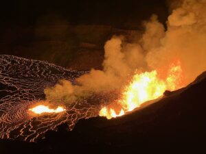
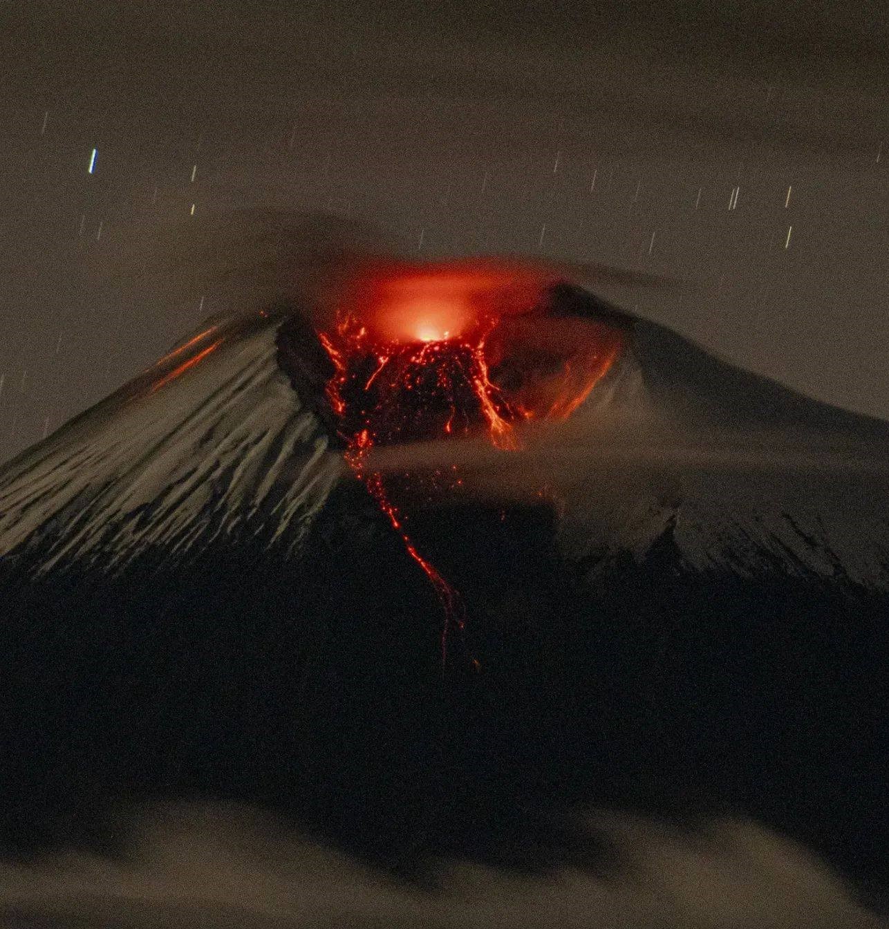
Episode 49 of the Kīlauea eruption, in the Halema‘uma‘u crater, abruptly ended around 5:05 PM HST on June 14, after 7.5 hours of lava fountain activity from the North vent. The final phase of this activity’s decline lasted less than 5 minutes, during which the lava fountain descended to a height of less than 60-80 meters. This photo illustrates the final stages of the episode, marked by periods of intense activity interspersed with periods of low activity.
Summit Observations:
Bright glow and large flames were visible from the south vent in Halemaʻumaʻu overnight, with intermittent glow and flames visible from the north vent. Degassing plumes from both vents are moving toward the southwest this morning. Lava flows that were partly incandescent and were still creeping overnight on June 14-15 are no longer moving or showing significant incandesence.
Low frequency pulses continue this morning, which is typical during the onset of pauses between eruptive episodes. There were three earthquakes within Kaluapele (Kīlauea caldera) in the past 24 hours, the largest of which was a M2.2 beneath the south rim of Halemaʻumaʻu.
Kīlauea summit deflation totaled 15.5 microradians during episode 49. Once the episode ended, inflation resumed and has since recovered 4.7 microradians of tilt at the summit tiltmeter at Uēkahuna (UWD).
With the eruption now paused, the sulfur dioxide (SO2) emission rate from the summit is likely now varying within a typical range of 1,000 to 5,000 tonnes per day.
Rift Zone Observations:
Rates of seismicity and ground deformation remain low in the East Rift Zone and Southwest Rift Zone. SO2 emissions from the East Rift Zone remain below the detection limit.
Source : HVO.
Photo : USGS/ T. Paladino.
Indonesia , Semeru :
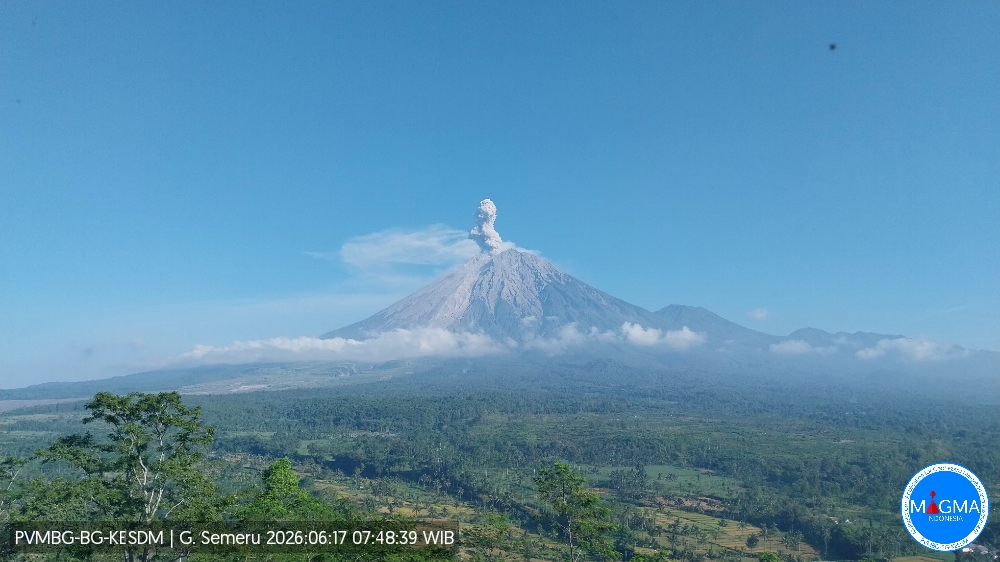
An eruption of Mount Semeru occurred on Wednesday, June 17, 2026, at 07:46 WIB, with an observed ash column height of approximately 800 m above the summit (approximately 4476 m above sea level). This ash column was gray and dense and was directed westward. The eruption was recorded by a seismograph with a maximum amplitude of 22 mm and a duration of 133 seconds.
VOLCANO OBSERVATORY NOTICE FOR AVIATION – VONA
Issued : June 17 , 2026
Volcano : Semeru (263300)
Current Aviation Colour Code : ORANGE
Previous Aviation Colour Code : orange
Source : Semeru Volcano Observatory
Volcano Location : S 08 deg 06 min 29 sec E 112 deg 55 min 12 sec
Area : East java, Indonesia
Summit Elevation : 11763 FT (3676 M)
Volcanic Activity Summary :
Eruption with volcanic ash cloud at 00h46 UTC (07h46 local).
Volcanic Cloud Height :
Best estimate of ash-cloud top is around 14323 FT (4476 M) above sea level or 2560 FT (800 M) above summit. May be higher than what can be observed clearly. Source of height data: ground observer.
Other Volcanic Cloud Information :
Ash cloud moving to west. Volcanic ash is observed to be gray. The intensity of volcanic ash is observed to be thick.
Remarks :
Eruption recorded on seismogram with maximum amplitude 22 mm and maximum duration 133 second.
Source et photo : PVMBG.
Ecuador , Sangay :
DAILY REPORT ON THE STATE OF SANGAY VOLCANO, Tuesday, June 16, 2026.
Geophysical Information Institute – EPN.
Surface Activity Level: High, Surface Trend: No Change
Internal Activity Level: Moderate, Internal Trend: No Change
Seismicity: From June 15, 2026, 11:00 AM to June 16, 2026, 11:00 AM:
Seismicity:
Explosion (EXP): 55
Rainfall/Lahars:
No rainfall has been recorded in the area. **Heavy rain could remobilize accumulated material and generate debris-laden mudflows (lahars), which could flow down the volcano’s flanks and into nearby waterways.**
Emissions/Ash:
Due to adverse weather conditions, no gas and/or ash emissions were observed by the monitoring camera system or satellite imagery. Furthermore, the Washington VAAC has not issued any emissions reports.
Observation:
Early this morning, an episode of incandescent lava flows was observed on the volcano’s flanks, reaching up to 1,400 meters below the crater. At the time of writing, the volcano remains shrouded in clouds.
Alert Level: Yellow
Source : IGEPN
Photo : Cristopher Cardenas / FB.
Colombia , Chiles / Cerro Negro :
San Juan de Pasto, June 16, 2026, 5:20 PM
Regarding the monitoring of activity at the Chiles-Cerro Negro Volcanic Complex (CVCCN), the Colombian Geological Survey (SGC), an agency under the Ministry of Mines and Energy, reports the following:
For the period of June 9-15, 2026, the main variations in monitored parameters, compared to the previous week, were as follows:
● Seismic activity remained at similar levels in terms of the number of events, despite a slight increase in energy released. Seismicity associated with rock fracturing processes predominated, followed by that related to fluid dynamics.
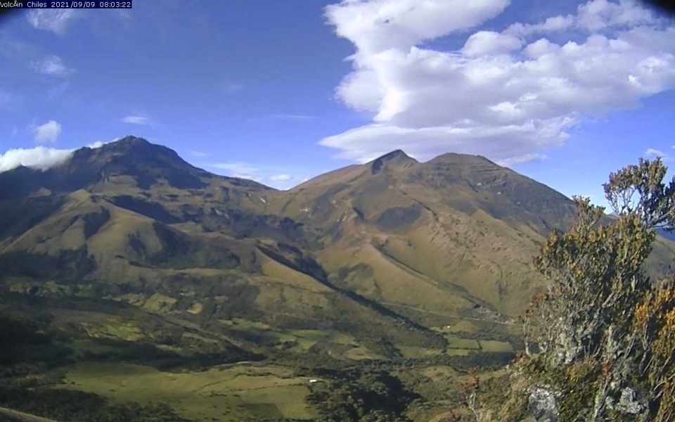
● Localized earthquakes were concentrated in two specific areas: one south and the other west of Chiles Volcano. In general, depths in both areas ranged from 1 to 5 km from the summit of Chiles Volcano (4,700 m altitude). The maximum recorded magnitude was 1.8.
● Analysis of information collected by satellite sensors and ground stations continued to show variations related to deformation processes in the volcanic zone.
Based on the assessment and correlation of monitored parameters, the SGC recommends closely monitoring developments through weekly bulletins and other information published through our official channels, as well as following instructions from local and departmental authorities and the National Unit for Disaster Risk Management (UNGRD).
Volcanic activity remains at the yellow alert level: active volcano with changes in baseline behavior of monitored parameters and other manifestations.
Source et photo : SGC.