June 16 , 2026.
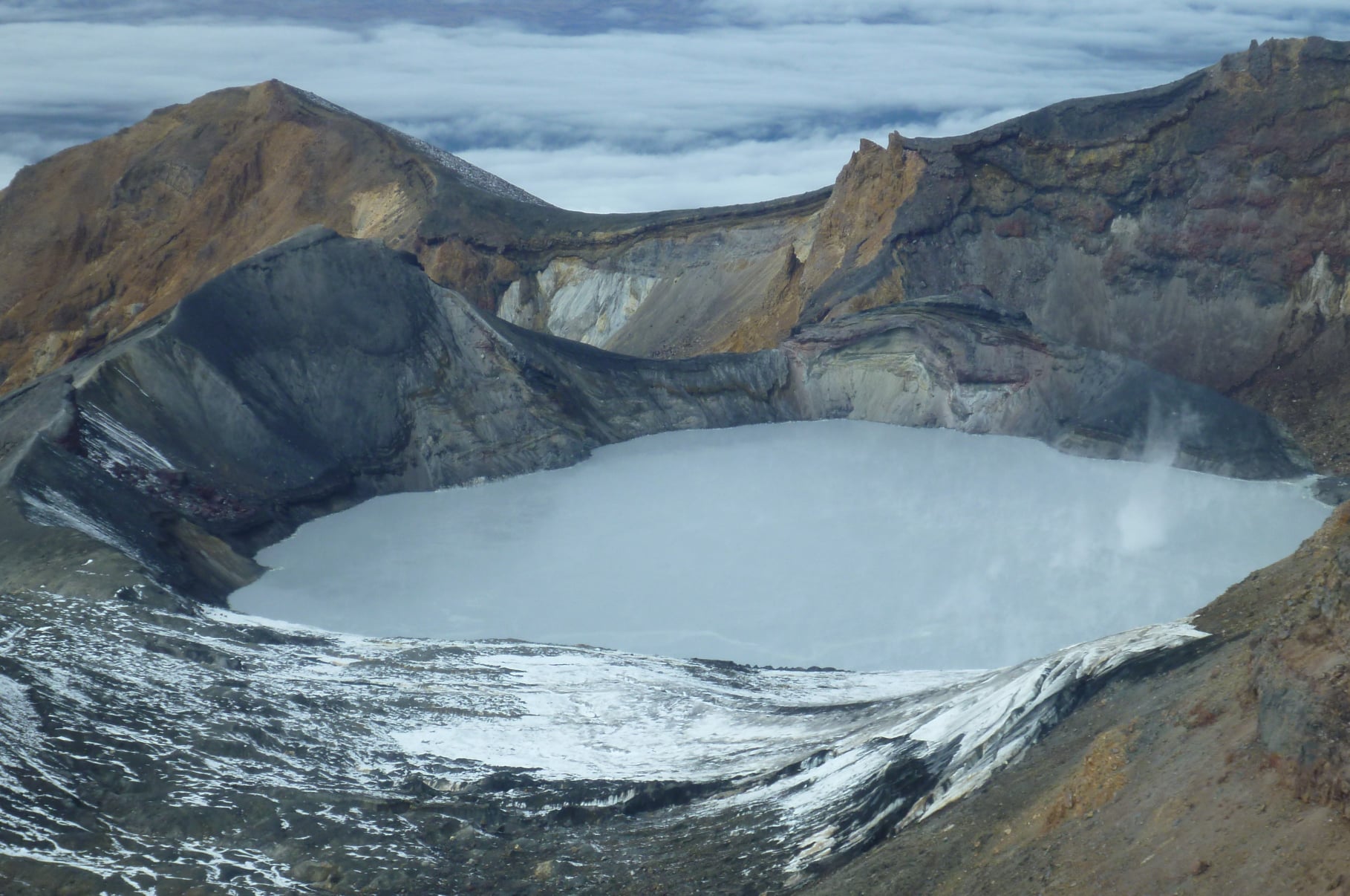
New Zealand , Ruapehu :
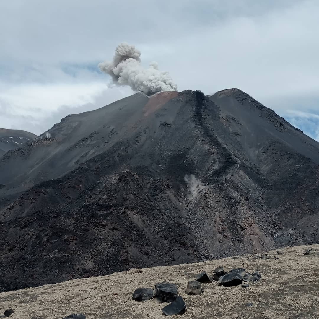
Update on Ruapehu: Slight increase in heat flow and gas output, continued small earthquakes beneath summit. Volcanic Alert Level remains at Level 1.
Published: Tue Jun 16 2026 9:45 AM
Since the last update in late April, Mt Ruapehu has continued to show low-level unrest, characterised by persistent small earthquakes beneath the summit area, minor fluctuations in Te Wai ā-moe (Ruapehu Crater Lake) temperature, and variable but generally low-to-moderate gas emissions. Volcanic activity remains within the range typical for minor unrest. The Volcanic Alert Level therefore remains at Level 1.
Lake temperatures have remained stable for the past 4 months (18–21.5°C), with short-term variability driven by weather and diurnal effects. A gradual warming trend has been evident since mid-May, also seen in a slight increase of heat flux from a low of 40 MW on 10 May to a high of 200 MW on 31 May. Persistent upwelling and sulphur slicks continue to be observed during sampling visits.
Gas output has been low to moderate, and measurements show slight increases in SO₂ and H₂S. Recent water sampling indicates minor changes, including a slight decrease in pH and shifts in Mg/Cl ratios, suggesting a small increase in magmatic fluid input. These changes remain modest relative to long-term trends.
Seismicity remains low-level but persistent, with small earthquakes beneath the summit and surrounding areas. A continuing sequence of repeating earthquakes beneath the summit (>700 events) is ongoing with most too small to be accurately located. Tremor levels are weak, with a brief increase observed in early June.
Observations are consistent with a dynamic hydrothermal system and intermittent input of volcanic gas and heat. Activity at Mt Ruapehu is within the range expected during minor volcanic unrest and the Volcanic Alert Level therefore remains at 1 and the Aviation Colour Code at green.
The Earth Sciences New Zealand Volcano Monitoring Group and National Geohazards Monitoring Centre will continue to closely monitor Ruapehu for any changes in activity. We will provide further updates when information becomes available or the status changes.
Source : Geonet / Yannik Behr / Duty Volcanologist
Photo : Geonet.
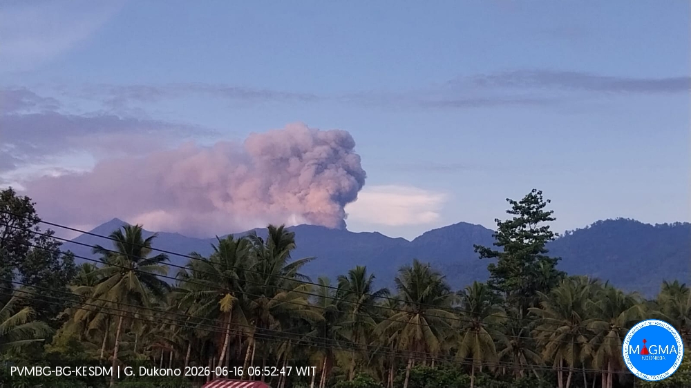
Indonesia , Dukono :
An eruption of Mount Dukono occurred on Tuesday, June 16, 2026, at 06:44 WIT, with an observed ash column reaching approximately 900 m above the summit (approximately 1987 m above sea level). This column, white to gray in color, was highly intense and moving southeast. At the time of writing, the eruption was still ongoing.
Seismic Observations
86 eruption earthquakes with amplitudes ranging from 7 to 34 mm and durations from 39.98 to 147.64 seconds.
75 low-frequency earthquakes with amplitudes ranging from 4 to 6 mm and durations from 28.63 to 39.76 seconds.
One deep volcanic earthquake with an amplitude of 7 mm and a duration of 14.28 seconds.
Three distant tectonic earthquakes with amplitudes ranging from 7 to 34 mm and durations from 51.4 to 269.79 seconds.
One continuous tremor earthquake with an amplitude between 1 and 6 mm, primarily 2 mm.
Recommendations
(1) Residents living around Mount Dukono and visitors/tourists are advised to refrain from any activity, climbing, or approaching the Malupang Warirang crater within a 4 km radius.
(2) Since volcanic eruptions with ashfall are periodic and ash dispersal depends on wind direction and strength, the ash cover area is not constant. People living around Mount Dukono are advised to always carry masks covering their nose and mouth to protect themselves from respiratory risks associated with volcanic ash.
Source et photo : PVMBG.
Argentina / Chile , Nevados de Chillán :
SPECIAL REPORT ON VOLCANIC ACTIVITY, June 15, 2026
The Argentine Geological and Mining Service (SEGEMAR), through its Argentine Volcanological Monitoring Observatory (OAVV) and in collaboration with the Southern Andes Volcanological Observatory (OVDAS) of Chile, reports that an increase in surface activity associated with the Nevados de Chillán volcanic complex was recorded on the morning of Monday, June 15, 2026.
Throughout the day, at least five (5) pulses of pyroclastic material from the most recently active crater were recorded, with a maximum height estimated at 160 m above the crater rim, as previously reported by the OAVV. The dispersion of this material was primarily directed towards the Southeast (SE). Subsequently, this surface activity continued with constant emissions, primarily gaseous, from the active crater.
For this reason, and as a precautionary measure, the Chilean Volcanological Observatory (OVDAS) raised the technical alert level for the Nevados de Chillán volcanic complex to YELLOW. The Argentine Volcanological Observatory (OAVV) will remain in constant contact with OVDAS, reporting any changes in volcanic activity and any potential impact on Argentine territory.
OBSERVATIONS:
Since the end of February 2026, monitoring stations located near the Nevados de Chillán volcanic complex, belonging to OVDAS, have recorded a sustained increase in fluid dynamic seismicity. Consequently, and considering the history of surface activity during the volcano’s last eruptive cycle between 2015 and 2022, low-magnitude explosions at the active crater are expected, affecting the immediate vicinity within a 1 km radius, entirely within Chilean territory. The risks associated with this type of activity include the ejection of ballistic pyroclastic flows, ash, and volcanic gases. However, the dispersal of ash over greater distances cannot be ruled out. At the time of writing this report, no significant changes in seismicity have been observed. However, the occurrence of new episodes with similar or higher energy characteristics cannot be ruled out, given the low seismic efficiency recorded for these pulses. Surface activity and gas plumes containing pyroclastic materials indicate an increase in the system’s surface activity. This situation could be linked to new instability conditions, possibly associated with the hydrothermal system during these initial phases. It should be noted that, according to information provided by the Volcanic Ash Advisory Center (CACV) of the National Meteorological Service (SMN), no volcanic ash has been detected suspended beyond the border between Argentina and Chile, and no impact has been observed to date on the population located in Argentine territory.
CONCLUSIONS
The technical alert level is raised. Monitoring and joint cooperation will continue with the Southern Andes Volcanological Observatory (OVDAS) of Chile, as well as with local and provincial authorities, and in constant coordination with the Federal Emergency Management Agency (AFE), within the framework of our National Integrated Risk Management System (SINAGIR). Any changes will be reported.
Source : Segemar.
Photo : Sernageomin.
Guatemala , Fuego :
Atmospheric conditions: Clear skies
Wind: Northeast
Rainfall: 44.5 mm
Activity:
During the night and early morning, weak to moderate explosions were recorded, accompanied by ash columns reaching heights of between 4,200 and 4,500 meters above sea level. This ash dispersed southwest of the volcanic complex over a distance of approximately 25 kilometers.
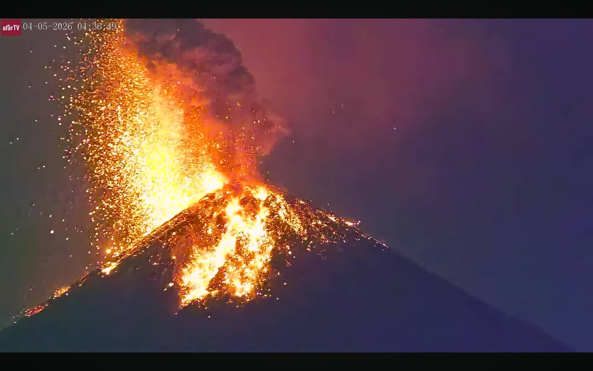
Ashfall has been reported in San Pedro Yepocapa. Avalanches have also been observed on the west, southwest, and south flanks, with some blocks reaching the vegetation. Some explosions are generating rumbling sounds, shockwaves, and noises similar to those of a locomotive. Due to this activity, it is dangerous to remain on the plateau because of the risk of falling ballistic debris. Weather conditions are conducive to low temperatures and could bring rain in the afternoon and evening.
Source : Insivumeh.
Photo : Afar tv.
Iceland , Bárðarbunga :
400 earthquakes recorded at Bárðarbunga.
The aviation color code for Bárðarbunga remains yellow while uncertainty continues regarding developments at the volcano. According to the Icelandic Meteorological Office, a yellow alert indicates that a volcano is showing signs of elevated activity above its normal background level.
In a statement issued by the Icelandic Meteorological Office, approximately 400 earthquakes have been detected at Bárðarbunga since the seismic swarm began shortly after 8 p.m. yesterday.
The largest earthquake measured magnitude 4.8, and seismic activity was at its highest until around 3 a.m.
Activity continues in the area
The Meteorological Office says the current swarm is among the most powerful observed since the last volcanic unrest at Bárðarbunga between 2014 and 2015, when the Holuhraun eruption occurred.
Earthquake activity is still being detected in the area, although the swarm appears to be decreasing in intensity.
“It is too early to determine whether the swarm is dying out,” the statement says.
The last comparable earthquake swarm at Bárðarbunga occurred in January 2025.
Source : Iceland monitor
Photo : Þórður Arnar Þórðarson