June 13 , 2026.
Italy , Stromboli :
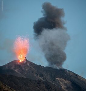
Stromboli Activity Update, June 12, 2026, 08:34 (06:34 UTC).
The National Institute of Geophysics and Volcanology, Etna Observatory, reports that at 05:12 GMT, monitoring cameras recorded a major explosion.
The explosion occurred in the northern part of the crater, and the eruptive projections primarily affected the upper part of the Sciara del Fuoco. Seismic activity recorded at 05:12 UTC showed a higher-than-normal amplitude signal associated with the major explosion, followed by a phase of moderate amplitude increase during the first 8 minutes.
The average signal amplitude increased rapidly, reaching high values at the time of the explosion, then decreased sharply to average values, where it remained. No significant changes were observed in the explosion frequency. Analysis of the high-frequency GNSS network data revealed no significant ground deformation.
Further updates will be provided shortly.
Source : INGV.
Photo : Stromboli stati d’animo / Sebastiano Cannavo.
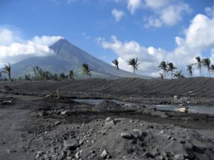
Alaska , Great Sitkin :
Slow eruption of lava continues within the summit crater. High spatial resolution satellite data from 11 June showed continued effusion on the eastern lava flow and the spalling of blocks from the lava dome in the crater. Typical slightly elevated surface temperatures were observed throughout the week when cloud cover was not obscuring the volcano. Seismic activity remains low, with occasional small volcanic earthquakes and seismic signals from minor rockfalls observed. Web camera observations showed no evidence of activity.
The current lava eruption began in July 2021 and has filled most of the summit crater and advanced into the valleys below. There have been no explosions at Great Sitkin Volcano since an event in May 2021. The volcano is monitored using local seismic and infrasound sensors, satellite data, and web cameras, and regional infrasound and lightning networks.
Source : AVO.
Photo : Loewen, Matt / Alaska Volcano Observatory / U.S. Geological Survey.
Indonesia , Dukono :
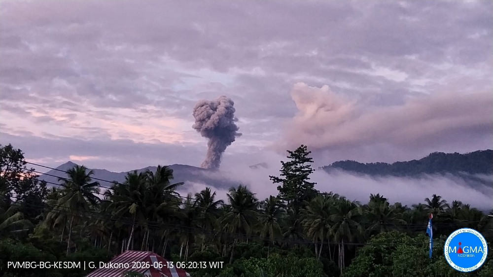
An eruption of Mount Dukono occurred on Saturday, June 13, 2026, at 06:14 WIT, with an observed ash column reaching a height of approximately 1300 m above the summit (approximately 2387 m above sea level). This column, white to gray in color, was highly intense and directed northwest. At the time of writing, the eruption was still ongoing.
Seismic Observations
90 eruption earthquakes with amplitudes between 6 and 23 mm and durations from 36.16 to 57.72 seconds.
16 low-frequency earthquakes with amplitudes between 3 and 6 mm and durations from 23.91 to 27.5 seconds.
Two distant tectonic earthquakes with amplitudes between 13 and 23 mm and durations from 73.34 to 76.99 seconds.
Continuous seismic tremor with amplitudes between 2 and 12 mm, predominantly 4 mm.
Recommendations
(1) Residents living near Mount Dukono and visitors/tourists are advised to refrain from any activity, climbing, or approaching the Malupang Warirang crater within a 4 km radius.
(2) Considering that eruptions with volcanic ash occur periodically and that the distribution of ash follows the direction and speed of the wind, so that the area where the ash lands is not constant, people living around Mount Dukono are advised to always carry masks/face coverings and mouth coverings to use when needed to avoid the threat that volcanic ash poses to the respiratory system.
Source et photo : PVMBG
Colombia , Puracé – Los Coconucos volcanic chain :
Popayán, June 12, 2026, 11:00 AM
Regarding the monitoring of activity in the Los Coconucos volcanic chain, the Geological Survey of Colombia (SGC), an agency under the Ministry of Mines and Energy, reports the following:
From the evening of Wednesday, June 10, until the date of publication of this bulletin, a significant increase in seismic activity has been recorded at the Puracé volcano compared to previous weeks. These seismic signals are associated with the movement of fluids (gases and liquids from the magma and interaction with the hydrothermal system) beneath the crater, located less than 3 km below the surface.
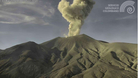
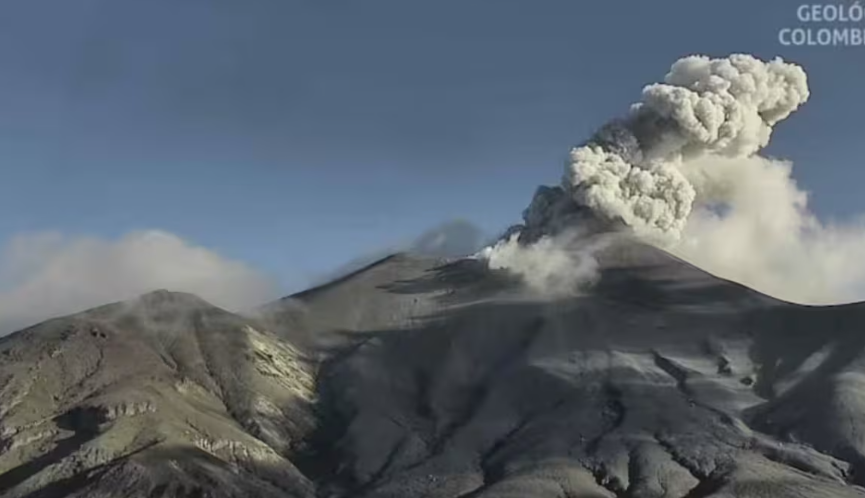
Ash emission occurred today, June 12, 2026, at 7:22 a.m. and was recorded by the Mina camera, located 2.2 km north of the summit of Mount Puracé.
Concurrently, the number of daily ash emissions has increased, dispersing to the northeast and northwest and reaching an altitude of 1.5 km above the summit of the volcano. Seismicity associated with rock fracturing within the volcano continues beneath Mount Puracé and Mount Piocollo, at depths between 1 and 3 km. Furthermore, sulfur dioxide emissions into the atmosphere continue, as does the surface deformation process between Mount Puracé, Mount Piocollo, and Mount Curiquinga. Thermal anomalies within the crater of Mount Puracé have been detected by satellite imagery and reported in the weekly bulletins published every Tuesday. In conclusion, the variations observed at the Puracé volcano and the Los Coconucos volcanic chain indicate that the system continues to evolve and that further ash emissions are possible, which will disperse according to the prevailing wind direction. Furthermore, additional changes in volcanic activity, potentially leading to increased energy emissions at the surface, cannot be ruled out.
The public is advised to avoid areas upstream of the volcanic chain and to remain attentive to reports and information disseminated through official SGC channels, as well as instructions from local and departmental authorities and the National Unit for Disaster Risk Management (UNGRD).
The alert level for volcanic activity remains yellow: active volcano with changes in the baseline behavior of monitored parameters and other manifestations.
Civil Aeronautics announced this morning, Monday, June 8, the temporary closure of operations at Guillermo León Valencia Airport in Popayán, due to activity recorded at the Puracé volcano and the presence of ash in the area of influence.
The decision was made after authorities identified ash particles derived from recent volcanic emissions, a situation which, according to the agency, poses a risk to the safe operation of aircraft.
In an official statement, Aerocivil explained that the measure meets strictly preventive criteria and aims to protect passengers, crews and airport staff.
Sources : SGC , El Pais .
Photos : SGC.
Costa Rica , Poas :
OVSICORI-UNA Volcanic Monitoring Weekly Bulletin, June 12, 2026
Latitude: 10.20°N;
Longitude: 84.23°W;
Altitude: 2,687 m
Current Activity Level: Alert
No eruptions were recorded this week. Tremor amplitude increased considerably last week and, despite a decrease this week, remains elevated. The tremor is low-frequency and monochromatic. The number of long-period events continues to decrease. Two volcano-tectonic earthquakes were recorded, one proximal and one distal, both of low magnitude (Ml < 1.3). High-frequency events were also recorded at stations near the crater. The geodetic network does not detect any significant deformation, other than crater contraction.
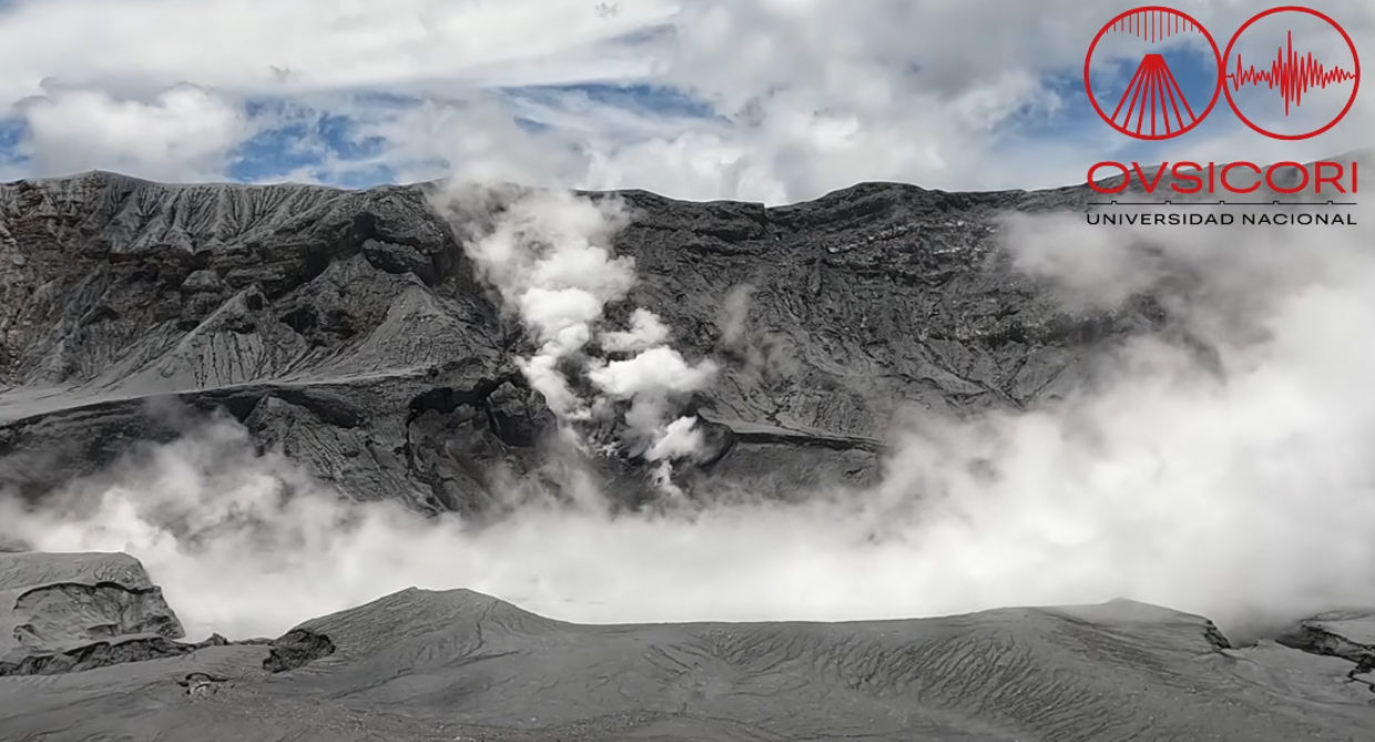
A slight decrease in the SO₂/CO₂ ratio was observed, from values close to 1.6 last week to values close to 1.3 this week. The H₂S/SO₂ ratio remains below 0.1. NOVAC stations recorded 40 ± 45 tonnes of SO₂ per day, a lower flow rate than the previous week (118 ± 60 t/d); however, the wind direction was unfavorable for measurements. The SENTINEL satellite detected the SO₂ plume on several occasions, with values in the range of 60 to 80 tonnes of SO₂. The level of the hyperacidic lake continues to rise slowly.
Source et photo: Ovsicori.