May 25 , 2026.
Bismarck Sea : South Rambutyo :
The Rabaul Volcano Observatory (RVO) reported that the eruption in the Central Bismarck Sea that began at around 01h15 on 8 May (based on regional infrasound data) continued during 13-20 May. During 13-14 May, plumes of steam and gas of variable densities and vigor rose from the eruption site and drifted to the W and NW; plumes of discolored water drifted from the site as well. By 15 May steam-and-gas plumes were identified in satellite imagery originating from two separate vent areas approximately 2.5 km apart; the eastern area was about 1.5 km in diameter, and the western area was about 500 m in diameter. A M 5.4 earthquake was recorded at around 11h13 on 15 May. During 15-16 May, pumice rafts identified in satellite images were producing thermal anomalies at up to 2 km from the source, suggesting that the rafts were initially thick. A 5-km-long area of thermal anomalies seen on 16 May, trending roughly WSW-ENE, was visible along the base of plumes; part of the thermal signature may have been from initially hot floating pumice.
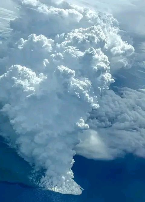
Small signatures indicating possible ash were detected on 16 May, though they were likely due to pumice pieces rapidly decompressing and disintegrating at the surface. Weather clouds obscured satellite views during parts of 15-17 May, making interpretations of the activity challenging, though data confirmed that the eruption remained submarine over this interval. During 18-20 May the steam plumes were more diffuse during previous days and drifted W and NW. Weak winds contributed to the plume rising to 5.5 km above the ocean’s surface. Plumes of discolored water drifted W, SW, and NW. According to a news article local fisherman observed and photographed the steam plumes, noting that there were dead fish nearby, and observing that “[the eruption] sounds like thunder and the sea smells like metal burning. »
Sources: Rabaul Volcano Observatory (RVO), Radio New Zealand, GVP.
Photo : Aini Tokapupia.
Hawaii , Kilauea :
HAWAIIAN VOLCANO OBSERVATORY DAILY UPDATE , U.S. Geological Survey
Sunday, May 24, 2026, 9:10 AM HST (Sunday, May 24, 2026, 19:10 UTC)
19°25’16 » N 155°17’13 » W,
Summit Elevation 4091 ft (1247 m)
Current Volcano Alert Level: ADVISORY
Current Aviation Color Code: YELLOW
Summary:
The Halemaʻumaʻu eruption of Kīlauea is paused. Glow was visible from both eruptive vents overnight. Summit inflation continues, and forecast models suggest that episode 48 will occur sometime between Monday, May 25 and Tuesday, May 26.
Overview:
The Halemaʻumaʻu eruption of Kīlauea is paused. Glow was visible from both eruptive vents overnight. Summit reinflation has continued since lava fountaining episode 47 ended on May 15. Forecast models suggest that episode 48 will occur sometime between Monday, May 25 and Tuesday, May 26.
No significant activity has been noted along Kīlauea’s East Rift Zone or Southwest Rift Zone.
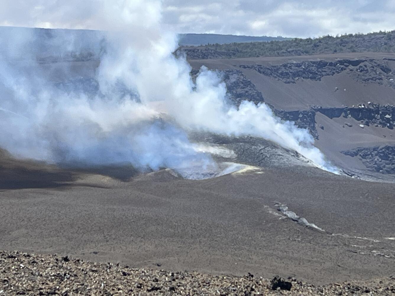
This telephoto view looking northwest shows the south vent (center), with the north vent (right) just out of view, in Halema‘uma‘u crater at the summit of Kīlauea. In the leadup to episode 47, the south vent had about 75 overflows, but only the north vent produced lava fountaining during episode 47. Both vents are degassing in the photo. With the eruption now paused, the sulfur dioxide (SO2) emission rate from the summit is likely now varying within a typical range of 1,000 to 5,000 tonnes per day.
Summit Observations:
Glow was visible from both Halemaʻumaʻu eruptive vents overnight, though it was brighter at the south vent.
Low-level seismic tremor continues during the current pause, and has fluctuated over the past day. Earthquake activity beneath Kīlauea summit is low at this time.
Kilauea summit inflation continues. This morning the inflation rate is low, and at a lower rate compared to earlier in the week. Since the end of lava fountaining episode 47 on May 15, the Uēkahuna tiltmeter (UWD) has tracked about 13.7 microradians of inflationary tilt (a small tilt offset was due to the M6.0 earthquake on the west side of the island on Friday evening). This instrument recorded 15.6 microradians of deflationary tilt during episode 47.
With the eruption now paused, the sulfur dioxide (SO2) emission rate from the summit is likely now varying within a typical range of 1,000 to 5,000 tonnes per day. Surface winds are steady out of the northeast at the summit this morning.
Rift Zone Observations:
Rates of seismicity and ground deformation remain low in the East Rift Zone and Southwest Rift Zone. SO2 emissions from the East Rift Zone remain below the detection limit.
Source : HVO.
Photo : USGS / N. Deligne.
Kamchatka , Sheveluch :
KVERT VOLCANIC ACTIVITY NOTICE (VAN)
Issued: May 24 , 2026
Volcano: Sheveluch (CAVW #300270)
Current aviation colour code: RED
Previous aviation colour code: orange
Source: KVERT
Notice Number: 2026-50
Volcano Location: N 56 deg 38 min E 161 deg 19 min
Area: Kamchatka, Russia
Summit Elevation: 3283 m (10768.24 ft), the dome elevation ~2500 m (8200 ft)
Volcanic Activity Summary:
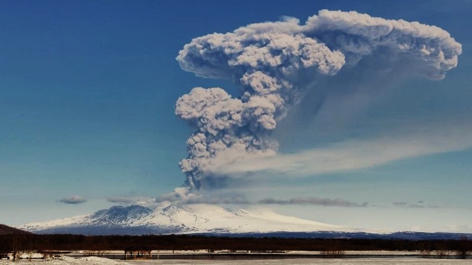
The extrusive-explosive eruption of the volcano continues. Explosions sent ash up to 10 km a.s.l., and ash cloud move to the east of the volcano.
The extrusive-effusive eruption of the volcano continues. Ash explosions up to 12 km (39,400 ft) a.s.l. could occur at any time. Ongoing activity could affect international and low-flying aircraft.
Volcanic cloud height:
10000 m (32800 ft) AMSL Time and method of ash plume/cloud height determination: 20260524/0450Z – Himawari-9 14m15
Other volcanic cloud information:
Distance of ash plume/cloud of the volcano: 23 km (14 mi)
Direction of drift of ash plume/cloud of the volcano: E / azimuth 94 deg
Time and method of ash plume/cloud determination: 20260524/0450Z – Himawari-9 14m15
Start time of explosion and how determined: 20260524/0430Z – Satellite data
Source : Kvert.
Photo : Jara Pokorny / Sopky světa FB via B. Duyck .
Indonesia , Sinabung :
Increased Volcanic Activity on Mount Sinabung, North Sumatra, May 22, 2026.
Mount Sinabung is an active volcano located in the Karo Regency, North Sumatra Province. Its seismic activity is primarily due to tectonic earthquakes, although volcanic earthquakes are also recorded, albeit in small numbers. Mount Sinabung’s current activity level is Level II (waspada) as of May 17, 2023.
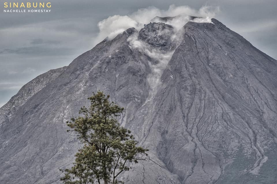
Seismic monitoring on May 21, 2026, revealed continuous tremors with a maximum amplitude of 4 mm, beginning at 11:53 PM (Western Indonesian Time) and continuing until the time of writing (May 22, 2026). Earthquake swarms, low-frequency earthquakes, and hybrid earthquakes, previously rarely observed, were also recorded. A thin to moderate white plume of smoke from the crater was observed rising between 50 and 500 meters above the lava dome. This increase in seismic activity requires heightened vigilance, given the potential hazards of Mount Sinabung, including phreatic and magmatic eruptions. A collapse of the lava dome is also possible should the pressure within the magmatic system increase significantly.
Since March 2024, the Center for Volcanology and Geological Hazard Mitigation (PVMBG) of the Bulgarian Geological Survey (BGN) has advised the public, tourists, and mountaineers to avoid all activity within a 2-kilometer radius of the summit of Mount Sinabung, as well as within a 3.5-kilometer radius of the southeastern sector of Mount Sinabung. In addition to the direct threat of ejected incandescent rock and ash, the public is also informed of the potential secondary risk of lahar flows, particularly during the rainy season. Lahars can flow down into rivers in the southwestern sector that originate at the summit of Mount Sinabung.
Regional authorities, including the Regional Disaster Management Agency (BPBD) of North Sumatra Province and Karo District, are requested to continue their active coordination with the Mount Sinabung observation post located in the village of Ndokum Siroga. The public should be kept informed of the latest developments regarding activity on Mount Sinabung.
Source : PVMBG.
Photo : Nachelle Homestay ( archive).
Italy , Campi Flegrei :
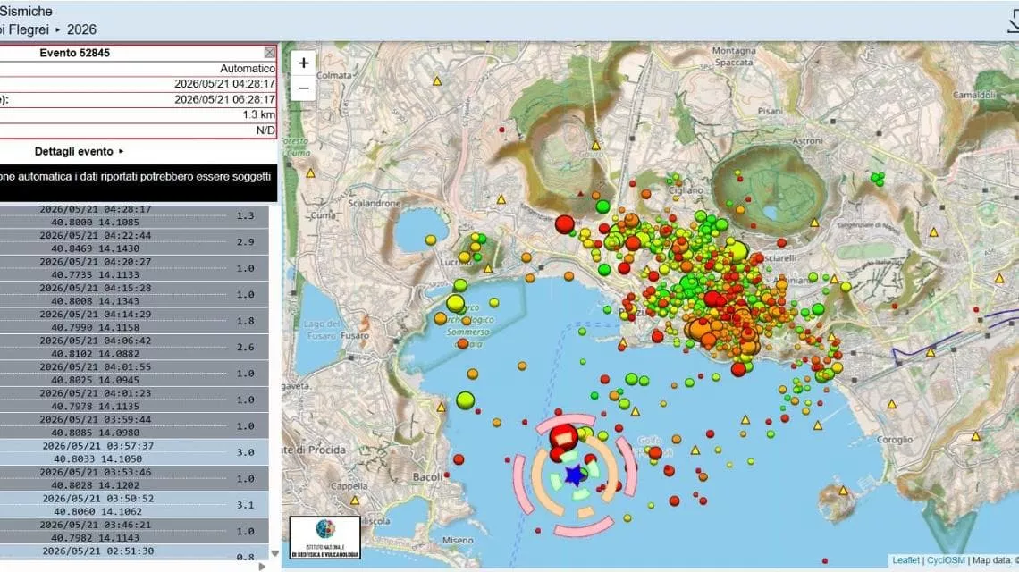
On May 21, a magnitude 4.4 earthquake, with its epicenter located offshore at a depth of 3 kilometers, was clearly felt by residents at 5:50 a.m. A series of aftershocks is ongoing, according to the National Institute of Geophysics and Volcanology (INGV): ten tremors have been detected. Following the temporary closure of metro line 2, service has resumed on the Cumana and Circumflegrea lines after infrastructure checks. EAV, the public transport company for the Campania region, also announced the resumption of service on line 7 between Soccavo and Monte Sant’Angelo.
No damage has been reported, apart from some minor ground subsidence in Bacoli, Belvedere Maurizio Valenzi, and Punta Epitaffio. As a precaution, schools in the Phlegraean Fields and the Neapolitan neighborhoods of Bagnoli and Fuorigrotta are closed. Municipal technicians are currently inspecting all schools in the red zone, as well as some school buildings in the First Municipality of Naples.
In accordance with the CCS directives issued by the Prefecture, today’s closure order applies to all schools located in the red zone, including private and public schools, as well as those under the jurisdiction of the Metropolitan Authority, in addition to the 10 municipal schools already mentioned.
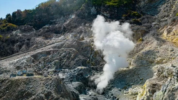
Potential CO2 spikes in the Solfatara-Pisciarelli area are also being monitored. Line L2 of the Italian Metropolitan Railway (Villa Literno-Naples), initially suspended along its entire route for civil engineering and building inspections, has since partially reopened. The Pozzuoli Archaeological Park remains closed. The situation continues to be closely monitored.
It was a rude awakening for the residents of Bacoli, Pozzuoli, and the entire region. The tremor was also felt in several neighborhoods of Naples, from Pianura to Vomero, and from Fuorigrotta to the historic center. This earthquake is among the strongest in the recent history of the Phlegraean Fields, although it was less powerful than the one on June 30, 2025, which reached a magnitude of 4.6.
Sources : La Republica .
Photos : INGV.