May 8 , 2026.
Indonesia , Dukono :
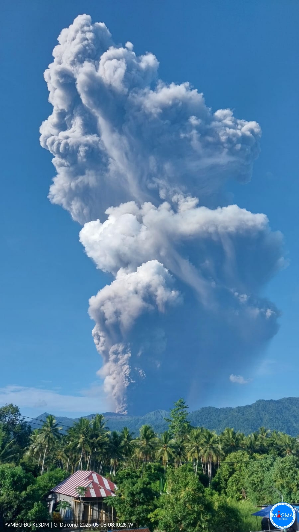
Mount Dukono Eruption, North Maluku, May 8, 2026
Volcanic activity at Mount Dukono, on Halmahera Island in North Maluku Province, remains high, and the alert level remains at II. The mountain, located in the Galela and Tobelo districts, experienced a decrease in eruptive activity in August 2025 but has seen a resurgence of explosive magmatic eruptions since March 30, 2026, with 199 eruptions. The eruptive columns have reached heights of 50 to 400 meters above the summit.
The latest eruption occurred on May 8, 2026, at 7:41 AM WIT. It was accompanied by a loud detonation, recorded on a seismogram with a maximum amplitude of 34 mm and a duration of 967.56 seconds. The observed eruptive column was white, gray to black, intensely colored, and rose approximately 10,000 meters above the summit. With ash dispersing primarily to the north, vigilance is essential. Residential areas and the city of Tobelo are at risk of volcanic ashfall. This situation increases public health risks and disrupts daily activities, including transportation and environmental hygiene. Visually, eruptive activity and seismicity have increased again since March 29, 2026, with an average of 95 eruptions per day.
Since December 11, 2024, the Center for Volcanology and Geological Hazard Mitigation (PVMBG), the geological agency, has advised the public, tourists, and climbers to avoid all activities within a 4-kilometer radius of the Malupang Warirang crater, the epicenter of volcanic activity. In addition to the direct threat of ejected incandescent rock and ash, the public is also advised of the potential secondary risk of lahar flows, particularly during the rainy season. These flows can descend the Mamuya River to the north and the Mede and Tauni Rivers to the northeast, which originate at the summit of Mount Dukono.
Local authorities, including the Regional Disaster Management Agency (BPBD) of North Maluku Province and North Halmahera District, are urged to maintain active coordination with the Dukono Volcano observation post located in Mamuya Village.
Source et photo : PVMBG.
Vanuatu Archipelago , Ambae :
On 1 May the Vanuatu Meteorology and Geohazards Department (VMGD) reported that the eruption at Ambae was ongoing and characterized as minor. Seismicity remained at high levels with the detection of continuous volcanic tremor and volcanic-seismic events. Sulfur dioxide emissions were detected in satellite images on 30 April and thermal anomalies with variable intensities were identified in satellite images on 1 May. Photos from 13h00 on 1 May showed emissions of steam, gas, and ash rising high above the crater rim. Continuous summit incandescence was also visible in photos. According to the Wellington Volcanic Ash Advisory Center (VAAC) a small ash plume rose 3 km (10,000 ft) a.s.l. and drifted NW on 6 May. The Alert Level remained at 3 (on a scale of 0-5), and the public was warned to stay outside of Danger Zone B, defined as a 3-km radius around the active vents in Lake Voui, and to stay away from drainages during heavy rains.
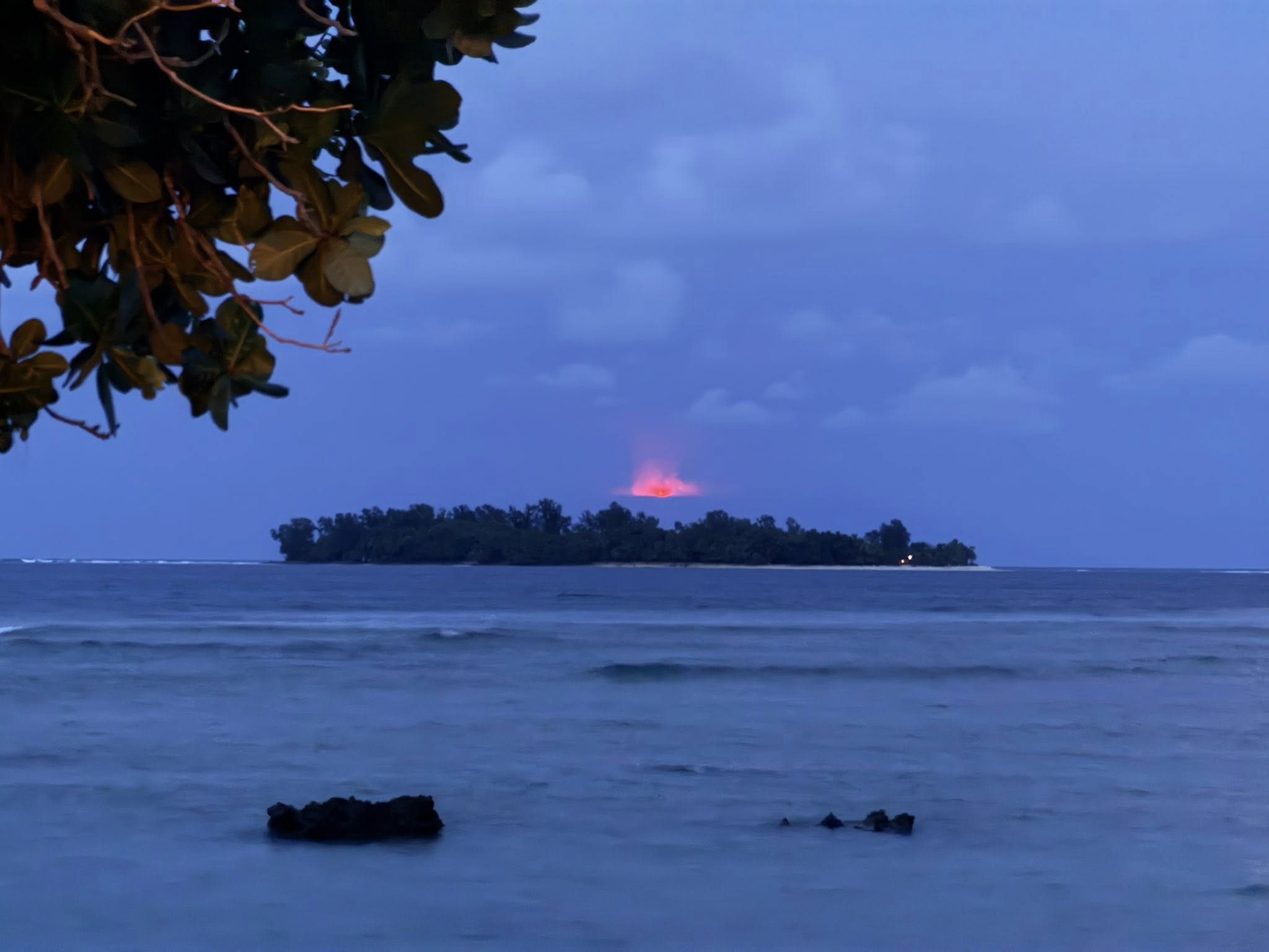
The island of Ambae, also known as Aoba, is a massive 2,500 km3 basaltic shield that is the most voluminous volcano of the New Hebrides archipelago. A pronounced NE-SW-trending rift zone with numerous scoria cones gives the 16 x 38 km island an elongated form. A broad pyroclastic cone containing three crater lakes (Manaro Ngoru, Voui, and Manaro Lakua) is located at the summit within the youngest of at least two nested calderas, the largest of which is 6 km in diameter. That large central edifice is also called Manaro Voui or Lombenben volcano. Post-caldera explosive eruptions formed the summit craters about 360 years ago. A tuff cone was constructed within Lake Voui (or Vui) about 60 years later. The latest known flank eruption, about 300 years ago, destroyed the population of the Nduindui area near the western coast.
Sources: Vanuatu Meteorology and Geohazards Department (VMGD), Wellington Volcanic Ash Advisory Center (VAAC), GVP.
Photo : MP Andrew Wilbur Napuat.
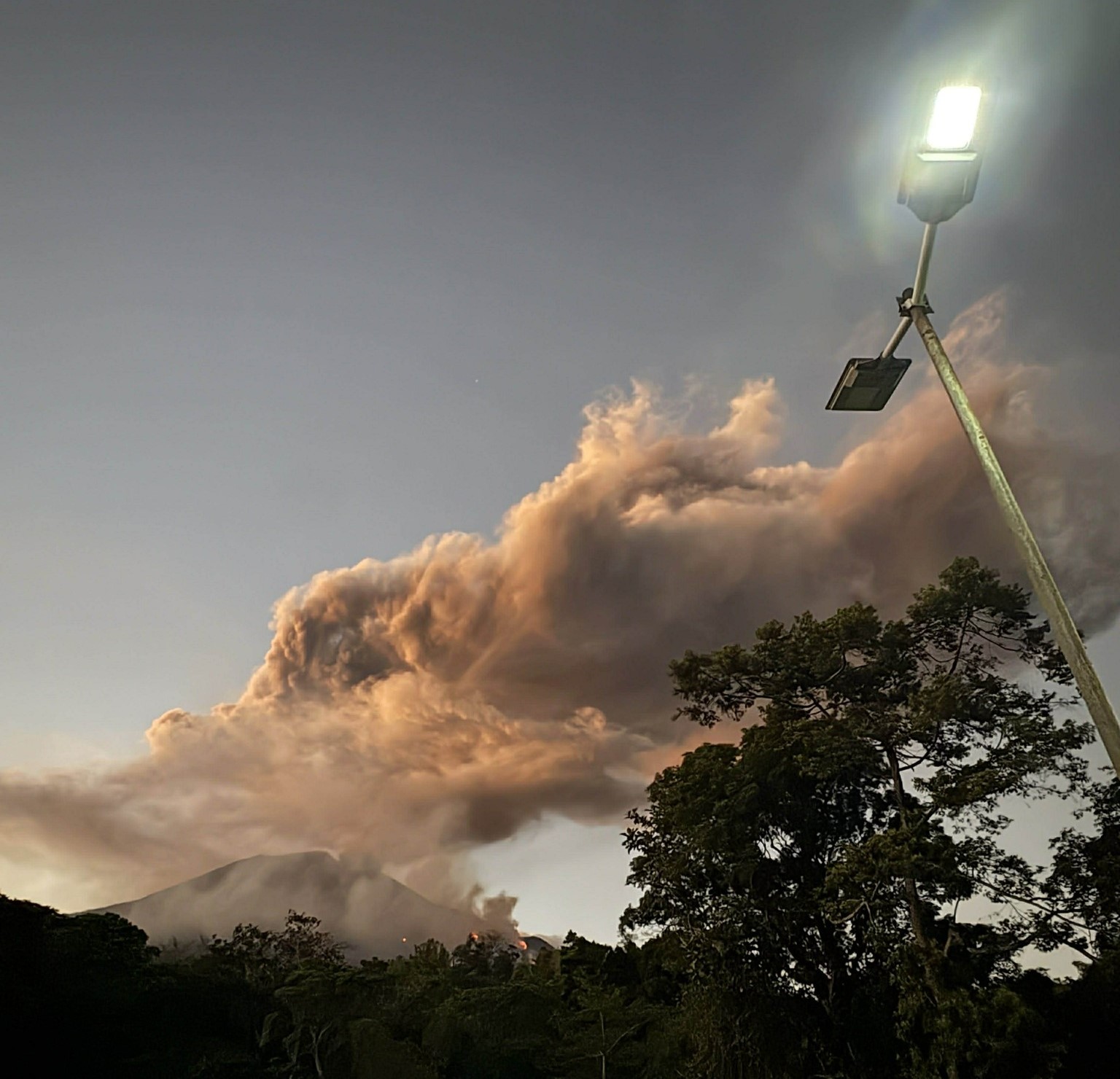
Philippines , Kanlaon :
The Philippine Institute of Volcanology and Seismology (PHIVOLCS) reported continuing eruptive activity at Kanlaon during 30 April-6 May. The seismic network recorded 7-54 daily volcanic earthquakes, including 2-15 daily periods of tremor lasting three minutes to nearly two hours. Sulfur dioxide emissions ranged from 1,154 to 2,098 tonnes per day. Emissions were visible daily that generally rose 300-1,800 m above the summit and drifted in multiple directions. There were 2-11 daily periods of ash emissions, each lasting for three minutes to nearly three hours. Notably, at 17h23 on 24 April, at 08h32 on 25 April, and at 18h30 on 26 April ash plumes visible in webcam images rose 800 m, 300 m, and 1,200 m above the summit, respectively, and drifted W and SW. The Alert Level remained at 2 (on a scale of 0-5); the public was warned to stay out of the 4-km-radius Permanent Danger Zone (PDZ) and pilots were advised to avoid flying close to the summit.
Kanlaon volcano (also spelled Canlaon) forms the highest point on the Philippine island of Negros. The massive andesitic stratovolcano is covered with fissure-controlled pyroclastic cones and craters, many of which are filled by lakes. The largest debris avalanche known in the Philippines traveled 33 km SW from Kanlaon. The summit contains a 2-km-wide, elongated northern caldera with a crater lake and a smaller but higher active vent, Lugud crater, to the south. Eruptions recorded since 1866 have typically consisted of phreatic explosions of small-to-moderate size that produce minor local ashfall.
Sources: Philippine Institute of Volcanology and Seismology (PHIVOLCS), GVP.
Photo : Regine Delos Santos Tomaquin.
Colombia , Puracé – Los Coconucos volcanic chain :
Popayán, May 5, 2026, 3:00 PM
Regarding the monitoring of activity at the Puracé volcano and the Los Coconucos volcanic chain, the Geological Survey of Colombia (SGC), an agency under the Ministry of Mines and Energy, reports the following:
During the week of April 28 to May 4, 2026, seismicity continued to be recorded, associated with fluid movements within the volcanic edifice, of the long-period (LP) type and tremor impulses (TR). These earthquakes were located below the crater of the Puracé volcano, at depths of less than 1 km, and were linked to circulation processes and the release of volcanic gases into the atmosphere, which dispersed according to the wind direction, reaching a maximum altitude of 1,665 m above the summit of the volcano. Continuous tremor persists beneath the craters of the Piocollo and Curiquinga volcanoes at depths of less than 3 km, linked to fluid dynamics within the volcanic system. Fracture seismicity remained similar to that of the previous week, both in number and energy, and was located mainly between the Puracé and Piocollo volcanoes at depths between 1 and 3 km, with magnitudes less than 1.
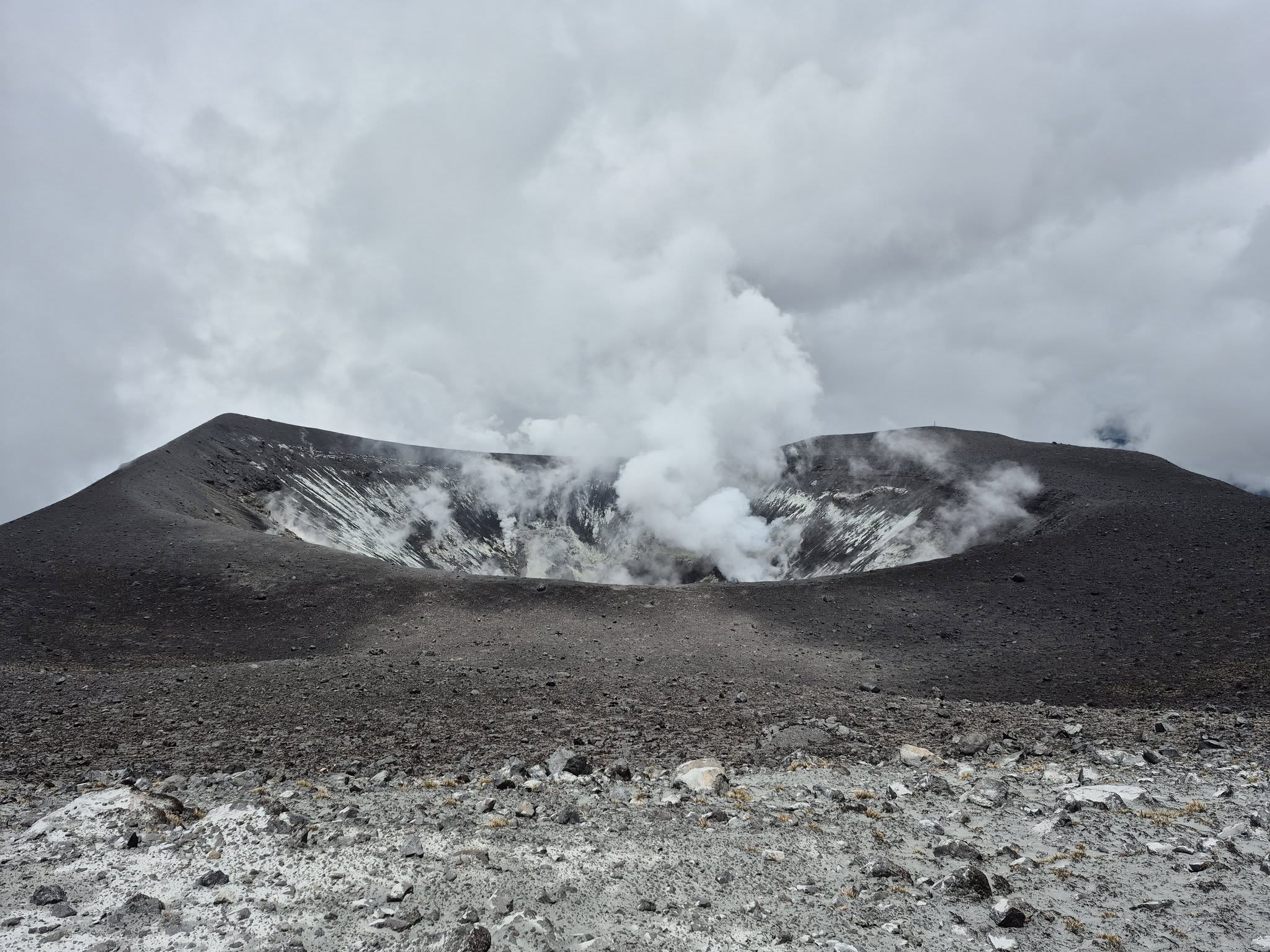
Low levels of sulfur dioxide (SO₂) emissions have been recorded, and gases continue to escape from fissures in the craters of the Curiquinga and Piocollo volcanoes. Furthermore, the slow deformation process continues between the Puracé, Piocollo, and Curiquinga volcanoes, which was detected after the eruptive episode of Curiquinga on January 20, 2025.
In conclusion, the variations observed in the Los Coconucos volcanic chain (Puracé volcano) indicate that the system continues to evolve and that further ash emissions and fallout are possible, depending on the prevailing wind direction. The public is advised to refrain from climbing to the upper reaches of the volcanic chain and to remain attentive to official bulletins from the Colombian Geological Survey (SGC).
The alert level for volcanic activity remains yellow: active volcano showing changes in monitored parameters and other manifestations.
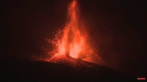
Source et photo : SGC.
Costa Rica , Poas :
OVSICORI-UNA Volcano Weekly Monitoring Bulletin, May 7, 2026
Latitude: 10.20°N;
Longitude: 84.23°W;
Altitude: 2,687 m
Current Activity Level: Alert
This week, two distal earthquakes were recorded on the eastern flank. The number of long-period events remains low compared to recent months. Background tremor exhibits variations in amplitude, reflecting the instability of the system. Two episodes of harmonic tremor were recorded, as well as short-duration tremor events.
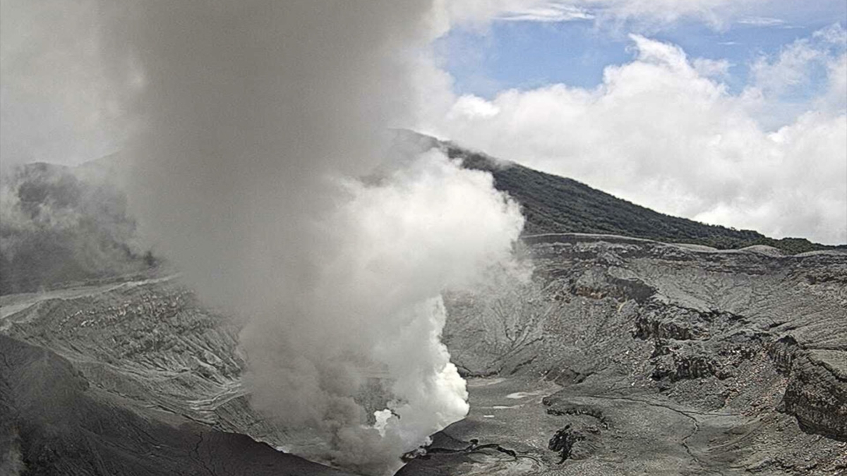
The geodetic network currently indicates significant vertical uplift at several stations on the volcano, notably VPEV and VPJA, where the signal has reached approximately 1 to 1.5 cm over the past three months, suggesting a possible acceleration since early April. Furthermore, the VPCR station, located north of the crater, is now beginning to show a significant uplift signal. Horizontally, a contraction of the crater is observed. The level of the hyperacidic lake remains stable. The lake temperature remains very high (>77°C).
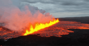
Source et photo : Ovsicori.