May 6 , 2026.
Hawaii , Kilauea :
HAWAIIAN VOLCANO OBSERVATORY STATUS REPORT , U.S. Geological Survey
Tuesday, May 5, 2026, 6:15 PM HST (Wednesday, May 6, 2026, 04:15 UTC)
19°25’16 » N 155°17’13 » W,
Summit Elevation 4091 ft (1247 m)
Current Volcano Alert Level: ADVISORY
Current Aviation Color Code: YELLOW
Activity Summary:
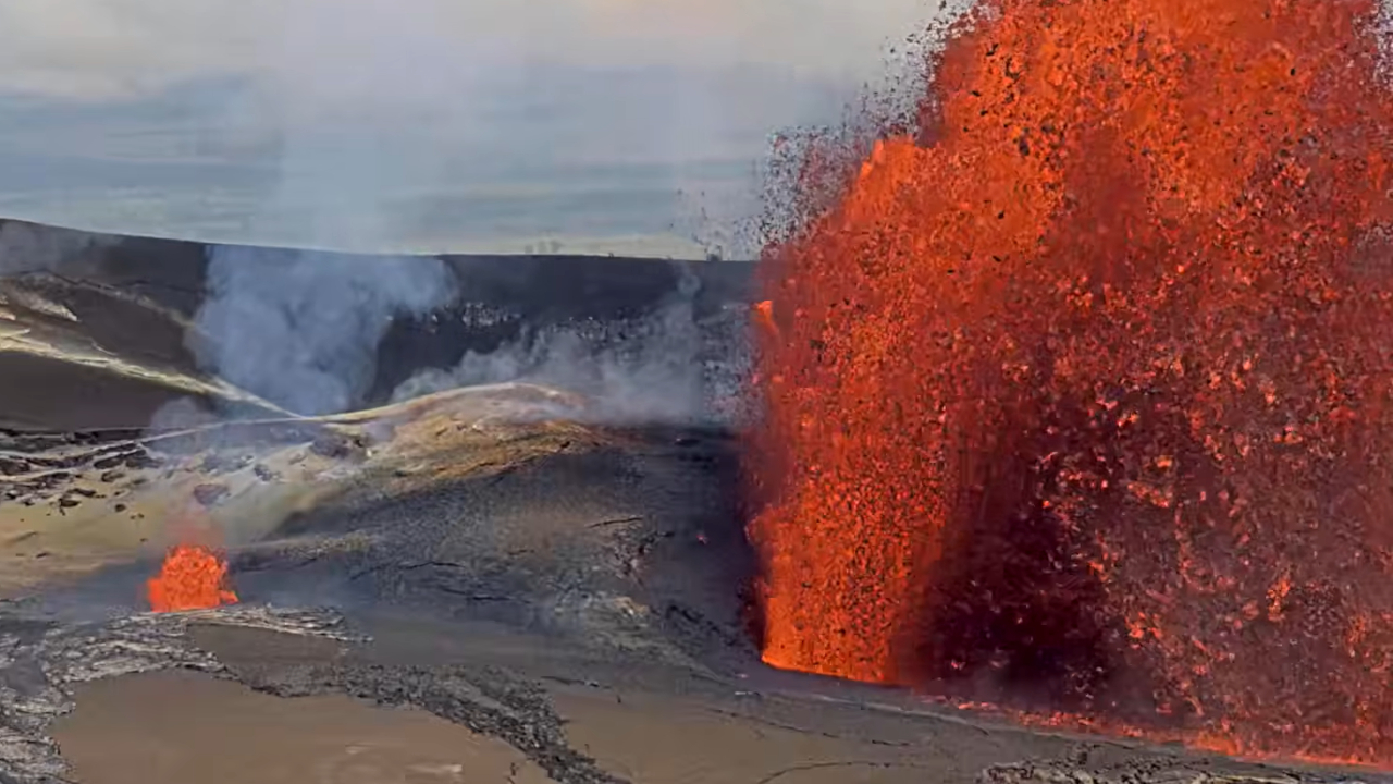
Episode 46 of the ongoing Halemaʻumaʻu eruption ended abruptly at 5:22 p.m. HST on May 5, 2026, after 9 hours of continuous lava fountaining, primarily from the north vent. The eruption is currently paused.
Tephra fell outside of the closed area of Hawaiʻi Volcanoes National Park along the north rim of Kaluapele (Kīlauea caldera), on Highway 11 between mile markers 30 and 34, and in adjacent communities. Tephra as large as 6 inches (15 centimeters) was observed falling on Highway 11 in the national park, and fine ash and Peleʻs hair were reported as far away as Mountain View.
Episode 46 Chronology:
Episode 46 of lava fountaining in Halemaʻumaʻu at the summit of Kīlauea began at 8:17 a.m. on May 5 and stopped at 5:22 p.m. HST the same day, after 9 hours of continuous lava fountaining from the north wind. The south wind never fountained during this episode, but it displayed periodic gas jetting and flames. The highest peak of instantaneous effusion rate of just over 310 cubic yards (240 cubic meters) per second occurred around 9:50 a.m. HST on May 5. Episode 46 saw an average effusion rate of 180 cubic yards (140 cubic meters) per second. An estimated 6 million cubic yards (4.6 million cubic meters) of lava erupted and covered about 60% of the Halemaʻumaʻu crater floor. The Uēkahuna tiltmeter (UWD) recorded about 14 microradians of deflationary tilt during episode 46.
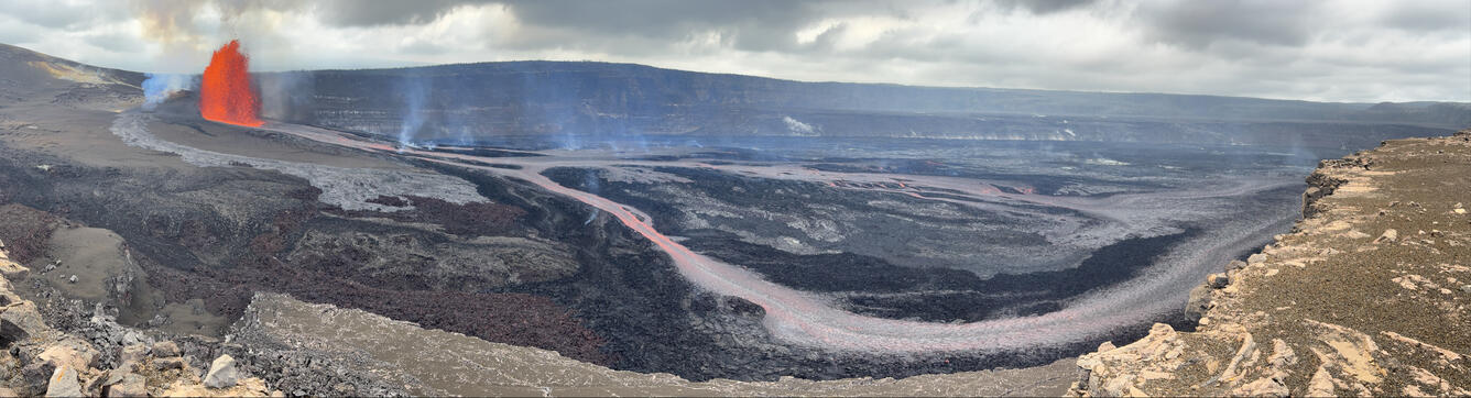
Episode 46 of lava fountaining in Halemaʻumaʻu began at the summit of Kīlauea at 8:17 a.m. HST on May 5th, 2026. This panoramic photograph, taken from the south rim of Halemaʻumaʻu at 1 p.m. HST, shows the lava fountain from the north vent feeding a channelized lava flow across the crater floor.
Episode 46 lava fountaining began approximately 19 hours after the onset of precursory lava overflows on afternoon of May 4. There were about 45 precursory overflows including about 24 from the north vent and about 21 from the south vent. Low-level dome fountaining from the north vent began at 8:17 a.m. HST this morning, and grew in vigor and height. South vent had one short-lived dome fountain and overflow after the onset of north vent fountaining, and subsequently had periodic gas jetting and flames. North vent fountains grew steadily until their peak between 10 and 10:30 a.m. HST. The main body of the fountains reached heights of 650 feet (200 m). After their peak, fountain height gradually decreased and were about 160 feet (50 meters) high just before the episode ended abruptly at 5:22 p.m. HST.
The north vent lava fountain produced significant heat and ash, feeding a plume that reached a maximum height of about 20,000 feet (6,000 meters) above sea level based on radar data reported by the National Weather Service and Washington Volcanic Ash Advisory Center. Light winds from the southeast directed the lower plume and tephra fall toward the north and northwest of Halemaʻumaʻu. Higher level winds directed the upper plume toward the north and northeast. At 8:52 a.m., the National Weather Service issued an ashfall advisory for Hawaiʻi Volcanoes National Park and areas to the north and northeast, including the communities of Volcano and Mountain View. This ashfall advisory is currently in effect until 8:00 p.m. HST. Tephra fell outside of the closed area of Hawaiʻi Volcanoes National Park along the north rim of Kaluapele (Kīlauea caldera), on Highway 11 between mile markers 30 and 34, and in adjacent communities. Tephra as large as 6 inches (15 centimeters) was observed falling on Highway 11, and fine ash and Peleʻs hair were reported as far away as Mountain View.
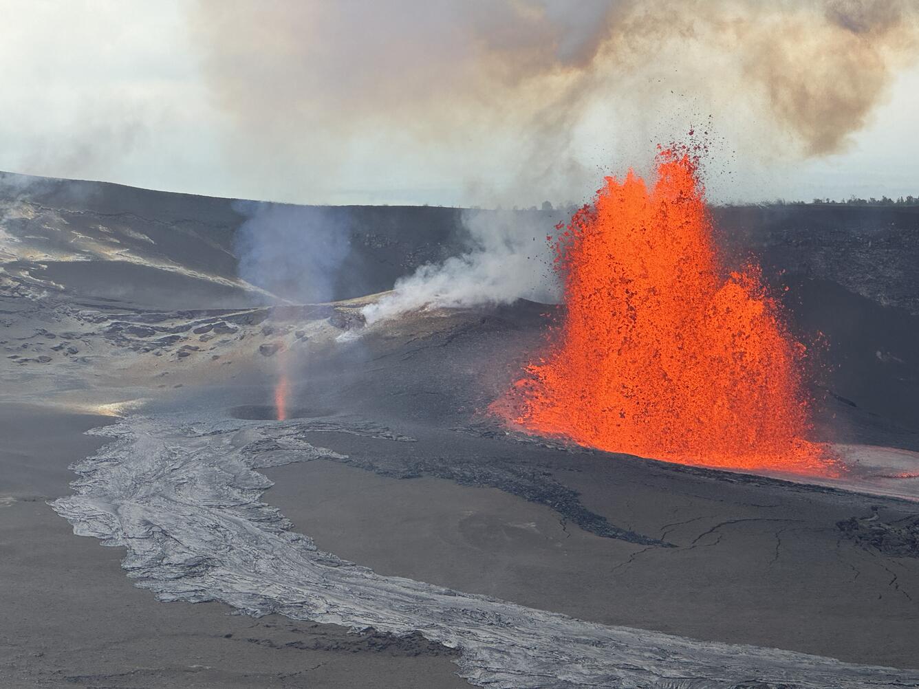
The North vent (right in the photo) of Halemaʻumaʻu crater emitted a lava fountain during episode 46 at the summit of Kīlauea on May 5, 2026. The South vent (left in the photo) emitted lava intermittently during the first half of episode 46, and gas jets continued to be visible during the second half of episode 46.
Earthquake activity during episode 46 was minor. Levels of seismic tremor rose and fell with fountaining and are now at typical levels for eruption pause.
Source : HVO.
Photos : USGS , USGS / M. Patrick .
Italy , Stromboli :
WEEKLY BULLETIN, April 27, 2026 to May 3, 2026. (Publication date: May 5, 2026)
ACTIVITY SUMMARY
Based on monitoring data, the following points should be noted:
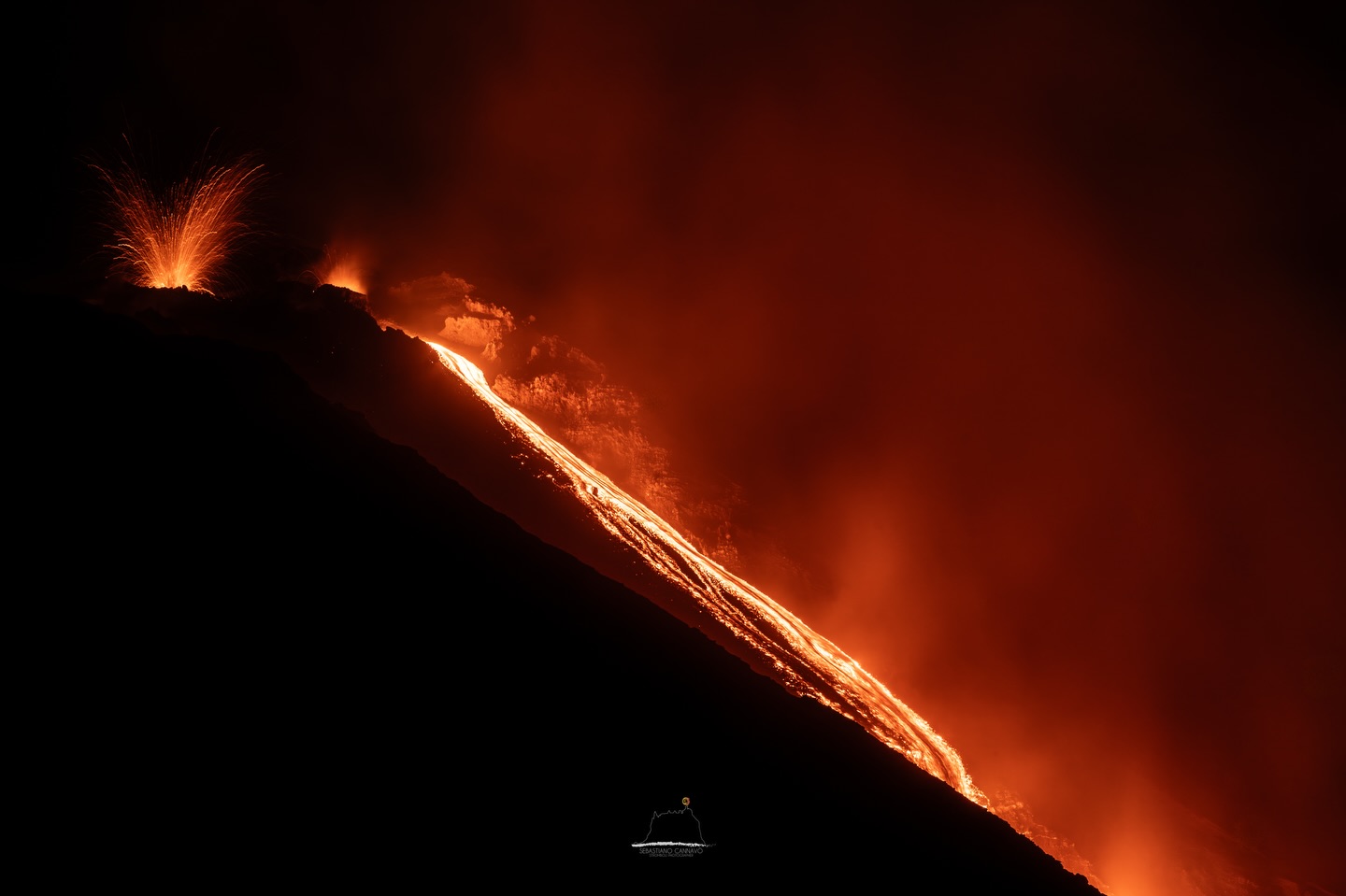
1) VOLCANOLOGICAL OBSERVATIONS: During this period, ordinary Strombolian-type eruptive activity was observed, interrupted by ejecta from the North Crater area. The total hourly frequency fluctuated between average (14 events/h) and high (19 events/h). The intensity of the explosions was mostly low to medium in the North and Central-South Crater areas.
2) SEISMOLOGY: The monitored seismic parameters showed no significant variation.
3) GROUND DEFORMATION: No significant variation was detected in the GNSS network time series.
4) GEOCHEMISTRY: SO₂ flux at an average level.
CO₂ flux from the ground in the Pizzo area (STR02) at average values.
C/S ratio in the plume: no update available last week.
Helium isotope ratio (R/Ra) dissolved in the thermal aquifer: data from the last sampling, carried out on March 23, 2026, are high (R/Ra = 4.50).
CO₂ flux from the ground in the San Bartolo area: at high values.
CO₂ flux from the ground in the Scari area: at average values.
5) SATELLITE OBSERVATIONS: Satellite-observed thermal activity in the summit area was generally moderate, with high values corresponding to the effusive event that began on May 4, 2026.
VOLCANOLOGICAL OBSERVATIONS
During the observation period, Stromboli’s eruptive activity was characterized by analyzing images recorded by the INGV-OE monitoring cameras located at an altitude of 190 m (SCT-SCV) and at Punta dei Corvi (SPCT). Explosive activity was primarily produced by five eruptive vents located in the North Crater area and by at least two vents located in the Central-South area.
Observations of explosive activity captured by the monitoring cameras:
Five active vents were observed in the North Crater area (N), two in sector N1, and three in sector N2, producing low (less than 80 m high) and medium (less than 150 m high) explosive activity. In addition, ejecta were observed at the vents in sector N2.
The eruptive products were primarily coarse materials (volcanic bombs and lapilli). The average frequency of explosions varied between 9 and 14 events per hour. In the Central-South (CS) crater area, two main vents were observed, exhibiting explosions of coarse material, sometimes mixed with fine material, of low to medium intensity. The average frequency of explosions varied between 4 and 6 events per hour.
Source : INGV.
Photo : Stromboli stati d’animo / Sebastiano Cannavo
Italy / Sicily , Etna :
MONTHLY BULLETIN, APRIL 2026. (Publication date: May 5, 2026)
ACTIVITY SUMMARY
Based on monitoring data, the following points should be noted:
1) VOLCANOLOGICAL OBSERVATIONS: Variable rate degassing activity at the summit craters, with episodic and moderate emissions of volcanic ash from the Bocca Nuova crater.
2) SEISMOLOGY: Low seismic activity due to fracturing, with the exception of the April 5 seismic swarm (Mmax = 3.6), which affected the northwest flank of the volcano. Average amplitude of volcanic tremor at medium level.
3) INFRASOUND: Low-energy infrasound activity with varying frequencies of occurrence between low and medium levels.
4) GROUND DEFORMATION: The DRUV dilatometer (Monte Ruvolo) showed a medium- to long-term trend toward moderate compression. The DRUV and the ECPN inclinometer (Cratere del Piano) also recorded slight variation coinciding with a phase of increased volcanic tremor.
5) GEOCHEMISTRY: SO₂ flux at an average level.
CO₂ flux from the ground (Etnagas): average values.
Partial pressure of dissolved CO₂ in groundwater (Rete EtnaAcque): no update.
Helium isotope ratio at peripheral sites: high values (latest data from April 13, 2026).
6) SATELLITE OBSERVATIONS: Over the past month, thermal activity observed by satellite in the summit area has been generally low, with a few isolated anomalies of moderate intensity.
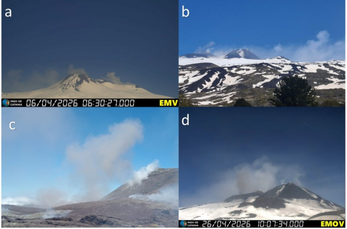
Degassing activity at the summit craters was recorded a) by the EMV camera on April 6 and b) by INGV-OE staff on April 20; a small amount of volcanic ash was observed c) during an inspection of the summit area by INGV-OE staff on April 19 and d) by the EMOV camera on April 26.
VOLCANOLOGICAL OBSERVATIONS
During the month, Etna’s volcanic activity was monitored through the analysis of images from the INGV Etna Observatory’s (INGV-OE) surveillance cameras and through various field observations conducted by INGV-OE staff. On some days, remote observations were intermittent due to unfavorable weather conditions at the summit.
Overall, during the period under review, Etna’s activity was characterized by degassing at varying rates from its summit craters, with episodic emissions of volcanic ash from the Bocca Nuova crater.
Analysis of CCTV footage and various on-site inspections conducted by INGV-OE staff (April 6, 11, 19, 20, and 26) revealed degassing activity of varying intensity at the Northeast Crater (CNE) and primarily fumarolic activity at the Voragine Crater (VOR) and the Southeast Crater (CSE). The Bocca Nuova Crater (BN) was characterized by degassing activity of varying intensity, with sporadic and weak emissions of reddish volcanic ash.
Source et photo : INGV.
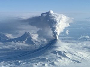
Indonesia , Awu :
Increased Seismicity at Mount Awu, North Sulawesi, May 5, 2026.
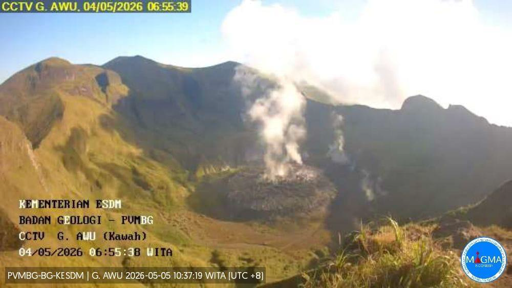
Mount Awu is an active volcano located in the Sangihe Islands Regency, North Sulawesi Province. Its seismic activity has been increasing since April 2024, particularly with regard to shallow volcanic earthquakes. Seismic swarms were recorded on August 24 and 25, 2024, with 364 shallow earthquakes recorded. The current activity level of Mount Awu has been at Level II (Waspada) since February 2, 2025.
Seismic monitoring on May 4, 2025, revealed an increase in shallow volcanic earthquakes, with a total of 74 events. On May 5, 2025, between midnight and noon (Indonesian local time), 15 shallow volcanic earthquakes, 2 deep volcanic earthquakes, and 23 distant tectonic earthquakes were recorded. No low-frequency earthquakes related to fluid circulation have been observed to date. A plume of white smoke, of varying thickness, rose from the crater between 20 and 200 meters above the lava dome. In addition to the above-normal seismic activity of Mount Awu, this increased seismicity is also thought to be influenced by the rise in tectonic earthquakes observed in North Sulawesi and the North Moluccas since April 2026.
This increased seismicity requires heightened vigilance, given the potential hazards associated with Mount Awu, which could trigger magmatic and phreatic eruptions. A collapse of the lava dome is also possible should the pressure within the magmatic system increase significantly.
Due to the increase in shallow volcanic earthquakes and the continued Level II (Waspada) activity, the public is advised to stay away from within a 3-km radius of Mount Awu’s crater and refrain from any activities there. The public is also urged to remain calm and follow the recommendations of the Geological Survey, through the Center for Volcanology and Geological Hazard Mitigation, and not to be misled by false and irresponsible information regarding Mount Awu’s activity.
Source et photo : PVMBG.
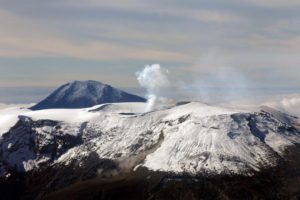
Alaska , Aniakchak :
ALASKA VOLCANO OBSERVATORY INFORMATION STATEMENT , U.S. Geological Survey
Tuesday, May 5, 2026, 2:31 PM AKDT (Tuesday, May 5, 2026, 22:31 UTC)
56°54’21 » N 158°12’32 » W,
Summit Elevation 4400 ft (1341 m)
Current Volcano Alert Level: NORMAL
Current Aviation Color Code: GREEN
Power has been sufficiently restored to the Port Heiden Receive Facility, allowing stable data flow from Aniakchak seismic stations. There are now enough reliable data to establish the real-time state of the volcano. Due to this, Aniakchak Volcano is moving from UNASSIGNED to GREEN/NORMAL.
Aniakchak Volcano had been at UNASSIGNED since December 23, 2025 due to a lack of data received from Aniakchak seismic stations following a power outage at the Port Heiden Receive Facility. Repairs have since been made to the Port Heiden Receive Facility, sufficiently restoring data flow from the Aniakchak network.
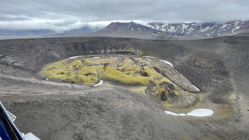
Aniakchak volcano, located in the central portion of the Alaska Peninsula, consists of a stratovolcano edifice with a 6 mile (10 km) diameter summit caldera. The caldera-forming eruption occurred around 3,500 years ago. Post-caldera eruptions have produced lava domes, tuff cones, and larger spatter and scoria cone structures, including Half-Cone and Vent Mountain, all within the caldera. The most recent eruption occurred in 1931 and created a new vent and lava flows on the western caldera floor while spreading ash over much of southwestern Alaska. Aniakchak volcano is 16 miles (26 km) southeast of the nearest community, Port Heiden, and 416 miles (670 km) southwest of Anchorage, Alaska.
Source : AVO.
Photo : Boyce, Ellie / Alaska Volcano Observatory / University of Alaska Fairbanks, Geophysical Institute.