April 22 , 2026.
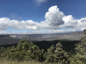
Hawaii , Kilauea :
HVO/USGS Volcanic Activity Notice
Current Volcano Alert Level: WATCH
Previous Volcano Alert Level: ADVISORY
Current Aviation Color Code: ORANGE
Previous Aviation Color Code: YELLOW
Issued: Monday, April 20, 2026, 9:16 PM HST
Source: Hawaiian Volcano Observatory
Notice Number: 2026/H186
Location: N 19 deg 25 min W 155 deg 17 min
Elevation: 4091 ft (1247 m)
Area: Hawaii
Volcanic Activity Summary:
Precursory low-level activity for episode 45 of the ongoing Halemaʻumaʻu eruption at the summit of Kīlauea began around 7:46 p.m. HST on April 20, 2026, with several overflows of lava from the north vent. Accordingly, HVO is raising the Alert Level for Kīlauea from ADVISORY to WATCH and the Aviation Color Code from YELLOW to ORANGE.
Low-level precursory activity can continue for hours to days before Kīlauea summit lava fountaining begins. The forecast for lava fountaining episode 45 to start is between April 21-26. Another VAN will be published when lava fountaining begins.
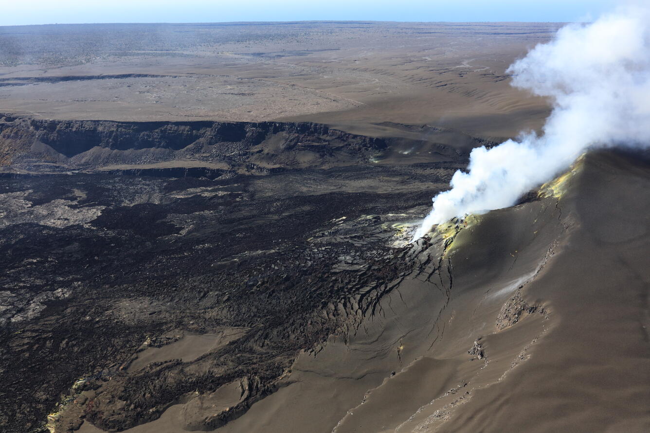
All eruptive vents and lava flows are confined to Halemaʻumaʻu crater within Hawaiʻi Volcanoes National Park. Tephra fall from volcanic ash clouds is greatest within 3 miles (5 km) of the vents, lighter ash and Pele’s Hair may stay suspended for large distances from the vents.
HAWAIIAN VOLCANO OBSERVATORY INFORMATION STATEMENT , U.S. Geological Survey
Tuesday, April 21, 2026, 3:33 PM HST (Wednesday, April 22, 2026, 01:33 UTC)
The USGS Hawaiian Volcano Observatory (HVO) is detecting shallow earthquakes beneath the south rim of Halemaʻumaʻu crater, as well as localized ground deformation, in the south caldera region of Kīlauea summit. This activity highlights the dynamic and hazardous nature of the closed area in Hawaiʻi Volcanoes National Park, where changes can occur quickly and can result in rapidly escalating hazards.
Heed National Park Service guidance and do not enter the closed area, where potentially life-threatening hazards can occur. Be aware that significant hazards exist around Kīlauea caldera from Halemaʻumaʻu crater wall instability, ground cracking, and rockfalls that can be enhanced by earthquakes.
If you are near the rim of Kīlauea caldera and feel the ground shaking, immediately move away from the edge
Summary
The USGS Hawaiian Volcano Observatory has detected small earthquakes beneath the south rim of Halemaʻumaʻu crater in the south caldera region of Kīlauea summit over the past few months. Over the past day, an additional 10 earthquakes magnitude-2 and smaller in this area have been detected at depths of 0.6–1.2 miles (1–2 km) below the surface. Most of these earthquakes are too small to be felt. Deeper earthquakes have also continued to occur beneath Kīlauea summit, but these have been observed typically throughout this eruption. HVO will continue to monitor this region closely as episode 45 of the ongoing Halema’uma’u eruption approaches and unfolds. Episode 45 lava fountaining is forecast to being between today, April 21, and April 26, 2026.
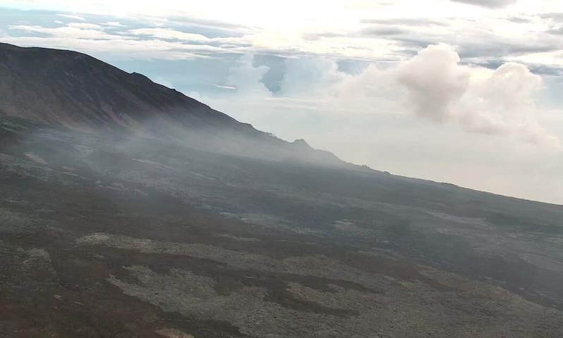
A separate and discrete swarm of 15 shallow magnitude-2 or smaller earthquakes occurred 0.6–1.2 miles (1–2 km) beneath the south rim of Halemaʻumaʻu crater in the south caldera region of Kīlauea summit during the final hours of episode 44 on April 9, 2026. Most of the earthquakes were too small to be felt; however, several earthquakes were felt by HVO staff monitoring the eruption from the rim of Halemaʻumaʻu crater. Ground deformation data show that an area of the south rim of Halemaʻumaʻu crater rose by several inches (centimeters), though the cause is uncertain. Due to a blanket of tephra that obscures visibility, HVO staff visiting the area after episode 44 did not observe any obvious ground cracks.
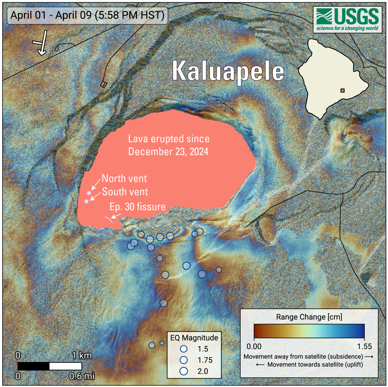
COSMO-SkyMed Second Generation (CSG) interferogram for the period from April 1 to April 9, 2026, covering Kīlauea volcano’s summit region. Each color fringe represents 1.55 centimeters (0.61 inches) of ground movement in the direction between the satellite and the ground (range change). The symbol in the upper left indicates the satellite’s orbit direction (arrow) and look direction (bar). Earthquakes are marked with circles with the size proportional to their magnitude. The lava flows covering the crater floor are represented by the pink polygon, the two vents (circles) and the Episode 30 fissure (line) are marked in light pink.
The patterns observed at the end of episode 44 are similar to patterns observed earlier in the eruption. During the start of episode 30 lava fountaining on August 6, 2025, earthquakes and ground deformation in this area of the south rim of Halemaʻumaʻu crater were associated with the opening of a new fissure on the south side of the crater, which erupted briefly only during episode 30. Earthquakes occurred minutes to hours before the new fissure began erupting in this area.
Additionally, this area on the south rim of Halemaʻumaʻu was affected by molten and hot tephra falling when the south vent lava fountain became suddenly inclined to the south during episode 38 on December 6, 2025, due to a change in the vent geometry. This molten material destroyed the original V3 livestreaming camera on the south rim of Halemaʻumaʻu. USGS Hawaiian Volcano Observatory monitoring cameras in this area provide situational awareness of hazards so that monitoring staff do not need to be in this hazardous area.
Source : HVO.
Photos : USGS , USGS / M. Zoeller , USGS.
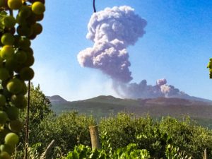
Italy , Stromboli :
WEEKLY BULLETIN, April 13, 2026 to April 19, 2026. (Issuance date: April 21, 2026)
ACTIVITY SUMMARY
Based on monitoring data, the following points should be noted:
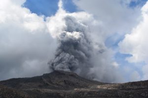
1) VOLCANOLOGICAL OBSERVATIONS: During the observation period, ordinary Strombolian-type eruptive activity was observed, interrupted by lava ejections and overflows from the North Crater area. The total hourly frequency varied between average (15 events/h) and very high (28 events/h).
The intensity of the explosions was mainly low to medium in the North and Central-South Crater areas.
2) SEISMOLOGY: The monitored seismic parameters did not show any significant variations.
3) GROUND DEFORMATION: GNSS network signals showed no significant changes. The tiltmeter network data for the week are not available.
4) GEOCHEMISTRY: SO₂ flux at an average level.
CO₂ flux from the soil in the Pizzo area (STR02): average values (approximately 7,500 g/m²/day).
CO₂/S ratio in the plume: no update available for last week.
Dissolved helium isotope ratio (R/Ra) in the thermal aquifer: data from the last sample taken on March 23, 2026, indicate high values (R/Ra = 4.50).
CO₂ flux from the soil in the San Bartolo area: high values.
CO₂ flux from the soil in the Scari area: average values.
5) SATELLITE OBSERVATIONS: Satellite-observed thermal activity in the summit area was generally moderate, with high values corresponding to the effusive event that began on April 18, 2026 and ended on April 19, 2026.

VOLCANOLOGICAL OBSERVATIONS
During the observation period, Stromboli’s eruptive activity was characterized by analyzing images recorded by the INGV-OE monitoring cameras located at 190 m (SCT-SCV) and at Punta dei Corvi (SPCT). Explosive activity was primarily produced by five eruptive vents located in the North Crater area and by at least two vents located in the Central-South area.
On April 15, due to adverse weather conditions, visibility from the crater terrace was insufficient for a precise description of the eruptive activity.
On April 18 and 19, a lava flow was observed in the North Crater area.
Observations of explosive activity captured by surveillance cameras
In the North Crater (N) area, five active winds were observed: two in sector N1 and three in sector N2. These vents produced explosive activity ranging from low (less than 80 m high) to medium intensity (less than 150 m high). In addition, weak but continuous ejection activity was observed at the vents in sector N2.
This activity was particularly intense for short periods on April 17. The eruptive products consisted mainly of coarse material (bombs and lapilli).
The average frequency of explosions ranged from 14 to 21 events per hour.
In the Central-South Crater (CS) area, two main winds were observed. These vents produced explosions of coarse material, sometimes mixed with fine material, ranging from low to medium intensity. The average frequency of explosions varied between less than 1 and 7 events per hour.
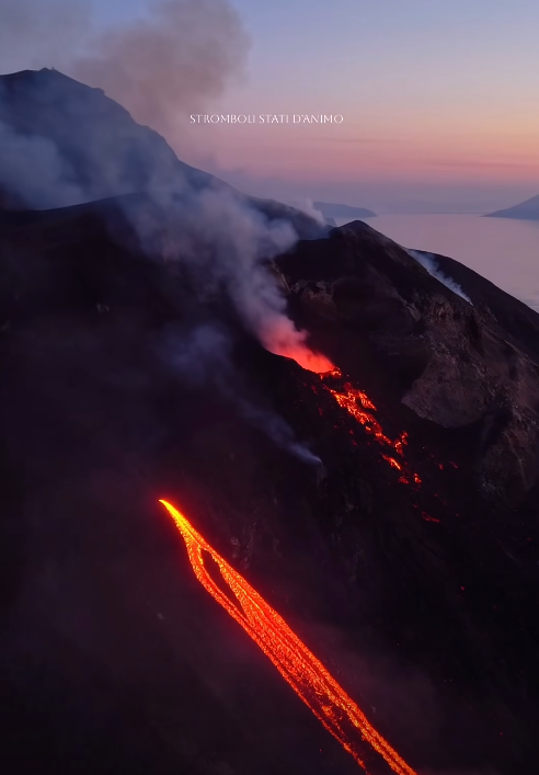
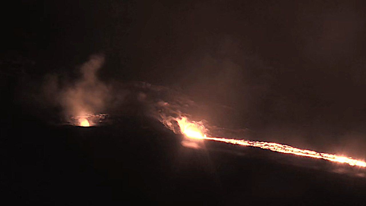
Lava Flow of April 18 and 19, 2026
On April 18 and 19, a lava flow occurred at the southern vent of the North Crater area, in sector N2, overlooking the Sciara del Fuoco.
Starting at 9:46 PM UTC on April 18, large blocks of incandescent lava began to flow down the upper part of the Sciara del Fuoco. A lava flow quickly formed. Within a few hours, this flow extended to the upper-middle section of the Sciara.
By early afternoon on April 19, the flow appeared to be slowly feeding and cooling.
Source : INGV.
Photos : Stromboli stati d’animo / Sebastiano Cannavo
Philippines , Bulusan :
BULUSAN VOLCANO ADVISORY , 22 April 2026 , 01:30 PM
Notice of increased seismic activity at Bulusan Volcano.
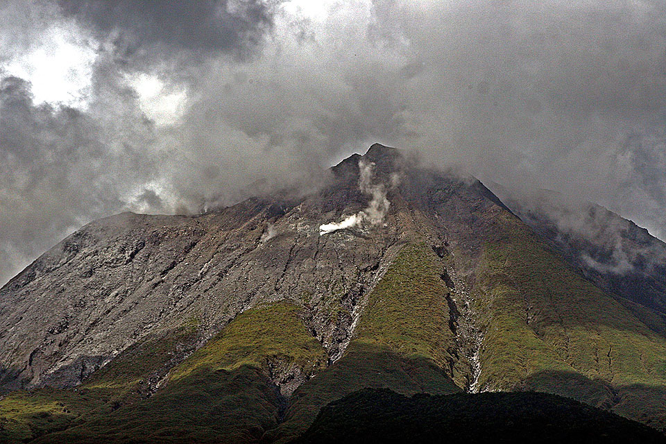
A total of one hundred one (101) volcano-tectonic (VT) earthquakes have been recorded by Bulusan Volcano Network (BVN) since 04:50 AM today, 22 April 2026. These VT events are generated by rock fracturing and with most originated within 2.5 kilometers depth beneath the northern edifice of Bulusan Volcano. In contrast, degassing activity from the summit crater and active vents has been very weak to moderate, while volcanic sulfur dioxide emission has remained at low levels and averaged 75 tonnes/day on 9 April 2026. The increase in volcanic earthquake activity could indicate shallow hydrothermal processes beneath the volcano which could lead to steam-driven or phreatic eruptions at any of its summit vents.
The public is reminded that Alert Level 1 (low-level unrest) prevails over Bulusan Volcano, and increased seismicity warns of increased chances of phreatic eruptions from any of its summit vents. Local government units are advised to strictly prohibit entry into the 4-kilometer radius Permanent Danger Zone (PDZ) and exercise vigilance in the 2-kilometer Extended Danger Zone (EDZ) on the southeast sector due to the possible impacts of volcanic hazards such as pyroclastic density currents or PDCs, ballistic projectiles, rockfall, avalanches, ashfall and others on these danger areas. Communities west and downwind of the volcano are also advised to prepare for ashfall in case phreatic eruption occurs, paying special attention to vulnerable members of the community including the elderly, expecting mothers, infants, and those with medical conditions. Civil aviation authorities must also advise pilots to avoid flying close to the volcano’s summit as ash from any sudden phreatic eruption can be hazardous to aircraft. Furthermore, people living within valleys and along river/stream channels especially on the western sectors of the edifice should be vigilant against sediment-laden stream flows and lahars in the event of heavy and prolonged rainfall should phreatic eruption occur.
DOST-PHIVOLCS is closely monitoring Bulusan Volcano’s condition and any new development will be relayed to all concerned.
Source et photo : DOST-PHIVOLCS
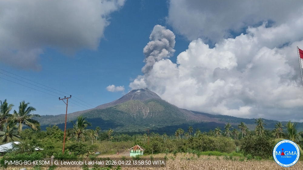
Indonesia , Lewotobi Laki-laki :
An eruption of Mount Lewotobi Laki-laki occurred on Wednesday, April 22, 2026, at 1:53 PM WITA. The observed ash column rose approximately 1,200 meters above the summit (approximately 2,784 meters above sea level). This ash column was gray and very dense, oriented in a southwest-west direction. The eruption was recorded by a seismograph, with a maximum amplitude of 5.9 mm and a duration of 227 seconds.
VOLCANO OBSERVATORY NOTICE FOR AVIATION – VONA
Issued : April 22 , 2026
Volcano : Lewotobi Laki-laki (264180)
Current Aviation Colour Code : ORANGE
Previous Aviation Colour Code : orange
Source : Lewotobi Laki-laki Volcano Observatory
Notice Number : 2026LWK031
Volcano Location : S 08 deg 32 min 20 sec E 122 deg 46 min 06 sec
Area : East Nusa Tenggara, Indonesia
Summit Elevation : 5069 FT (1584 M)
Volcanic Activity Summary :
Eruption with volcanic ash cloud at 05h53 UTC (13h53 local).
Volcanic Cloud Height :
Best estimate of ash-cloud top is around 8909 FT (2784 M) above sea level or 3840 FT (1200 M) above summit. May be higher than what can be observed clearly. Source of height data: ground observer.
Other Volcanic Cloud Information :
Ash cloud moving from southwest to west. Volcanic ash is observed to be gray. The intensity of volcanic ash is observed to be thick.
Source et photo : PVMBG.
La Réunion Island , Piton de la Fournaise :
Press release from the Paris Institute of Earth Physics / Piton de la Fournaise Volcanological Observatory, April 21, 2026 – 4:10 PM local time – 12:10 PM UTC
Tremor Ceases
Since April 20, 2026, we have observed a decrease in volcanic tremor, which had been recorded again since April 19.
This signal, associated with the circulation of magmatic and/or gaseous fluids at shallow depths, is now indistinguishable from ambient seismic noise, indicating that the tremor has ceased.
Nevertheless, a resumption of the eruption in the coming days cannot be ruled out, particularly given the apparent signs of inflation within the volcano (parameters to be confirmed in the coming days).
Slight degassing is still being observed at the eruptive sites associated with the activity from February 13 to April 12, located at an altitude of 2056–2120 m on the east-southeast flank of the volcano.
Source : OVPF-IPGP.
Photo : Reunion la 1ere