April 6 , 2026.
La Réunion Island , Piton de la Fournaise :
Press release from the Paris Institute of Earth Physics / Piton de la Fournaise Volcanological Observatory, April 6, 2026 – 7:00 a.m. local time – 3:00 a.m. UTC
Tremor
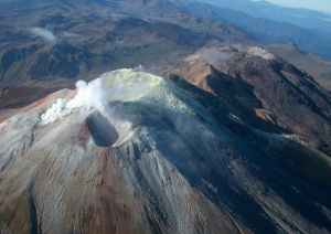
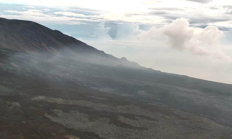
A tremor* has been recorded since 8:40 p.m. (local time, 4:40 p.m. UTC) on April 3. The source of this tremor is located on the east-southeast flank of the volcano and is positioned in the same location as during the eruptive activity phases from February 23 to April 3.
Over the last 24 hours, the amplitude of the tremor has decreased slightly. This tremor is not accompanied, at this stage, by lava emissions at the surface; only a slight plume of gas is being emitted from the eruptive fissure associated with the activity from February 13 to April 3, located at an altitude of 2,056 m on the east-southeast flank of the volcano. This tremor nevertheless indicates the presence of magma at shallow depths; thus, a resumption of lava emissions cannot be ruled out.
Last night, an incandescent point was observed at the summit of the eruptive cone, in the area of the degassing observed on April 4th. This incandescent point did not originate from lava ejecta. However, it is certain that material at very high temperatures, and potentially molten material, still resides inside the cone. In the absence of in-situ analysis, several hypotheses can be considered: it could be a fracture resulting from a partial landslide at the summit of the recently formed cone, exposing this incandescent zone, or a small upwelling of material from the eruptive conduit. This incandescent point was no longer visible by the end of the night, on the morning of April 6th.
It should be noted that in the past, phases of tremor without lava emission have already been observed at Piton de la Fournaise, although this remains rare, such as at the end of the September-October 2022 eruption, during which this phase lasted a little over 27 hours.
Seismicity
Since the cessation of surface eruptive activity on April 3 at 00:10 (local time), seismicity beneath the summit has decreased, with 6 shallow volcano-tectonic earthquakes recorded in the last 24 hours.
Deformation
Concurrently, slight inflation of the summit area of the volcano has been recorded again, indicating a re-pressurization of the shallow magma reservoir.
*tremor: a continuous seismic signal, generally low frequency, generated by the movement of magma near the surface and/or its degassing.
Source : OVPF / IPGP.
Photos : OVPF , Reunion la 1ere
Kamchatka , Sheveluch :
KVERT VOLCANIC ACTIVITY NOTICE (VAN)
Issued: 20260406/0459Z
Volcano: Sheveluch (CAVW #300270)
Current aviation colour code: ORANGE
Previous aviation colour code: red
Source: KVERT
Notice Number: 2026-37
Volcano Location: N 56 deg 38 min E 161 deg 19 min
Area: Kamchatka, Russia
Summit Elevation: 3283 m (10768.24 ft), the dome elevation ~2500 m (8200 ft)

Volcanic Activity Summary:
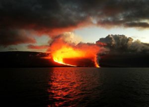
An explosive-extrusive eruption of the volcano continues, accompanied by powerful gas-steam activity; a new block of lava continues to grow in the northern part of the lava dome. Satellite data showed no new ash explosions have been observing on the volcano at now, but ash cloud on the altitude 8.5-9.0 km a.s.l. continues to move for 300 km to the north-east of the volcano.
This explosive-extrusive eruption of the volcano continues. Ash explosions up to 12 km (39,400 ft) a.s.l. could occur at any time. Ongoing activity could affect international and low-flying aircraft.
Volcanic cloud height:
NO ASH CLOUD PRODUSED
Other volcanic cloud information:
NO ASH CLOUD PRODUSED
Source : Kvert
Photo : Yu. Demyanchuk, IVS FEB RAS, KVERT (archive).
Indonesia , Dukono :
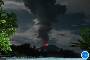
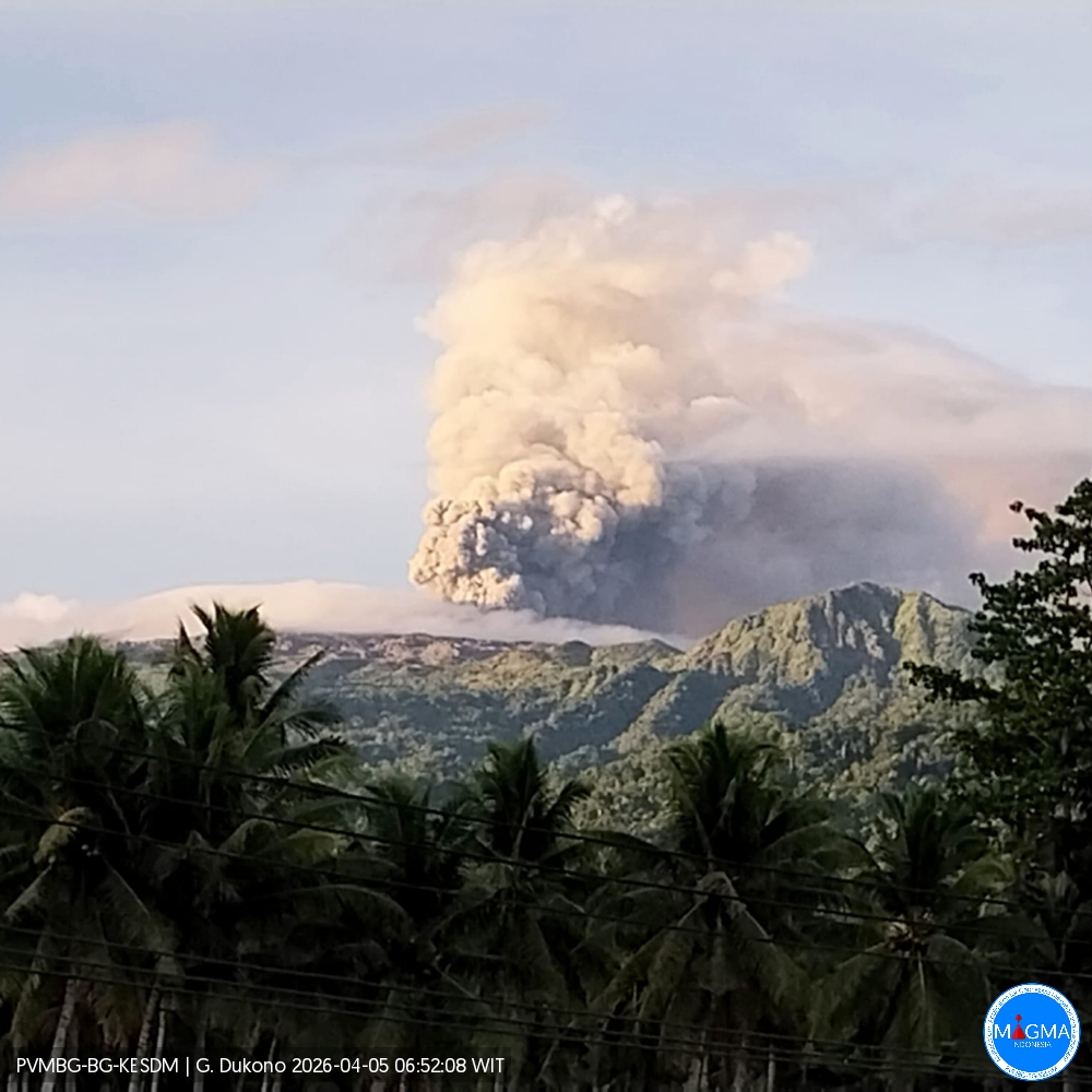
Mount Dukonoa experienced an eruption on Monday, April 6, 2026 at 9:26 AM WIT. An ash column was observed approximately 1,000 meters above the summit (at an altitude of about 2,087 meters). This ash column, white to gray in color, was intensely moving westward. At the time of writing, the eruption was still ongoing.
Seismic Observations
83 eruptive earthquakes with amplitudes between 6 and 34 mm and durations from 32.1 to 166.67 seconds.
2 deep volcanic earthquakes with amplitudes between 7 and 8 mm and durations from 8.28 to 15.24 seconds.
23 distant tectonic earthquakes with amplitudes between 6 and 34 mm and durations from 60.64 to 158.57 seconds.
Continuous seismic tremor with amplitudes between 1 and 4 mm, predominantly 2 mm.
Recommendations
(1) Residents living near Mount Dukono and visitors/tourists are advised to refrain from any activity, climbing, or approaching the Malupang Warirang crater within a 4 km radius.
(2) Considering that eruptions with volcanic ash occur periodically and that the distribution of ash follows the direction and speed of the wind, so that the area where the ash lands is not constant, people living around Mount Dukono are advised to always carry masks/face coverings and mouth coverings to use when needed to avoid the threat that volcanic ash poses to the respiratory system.
Source et photo : PVMBG.
Ecuador , El Reventador :
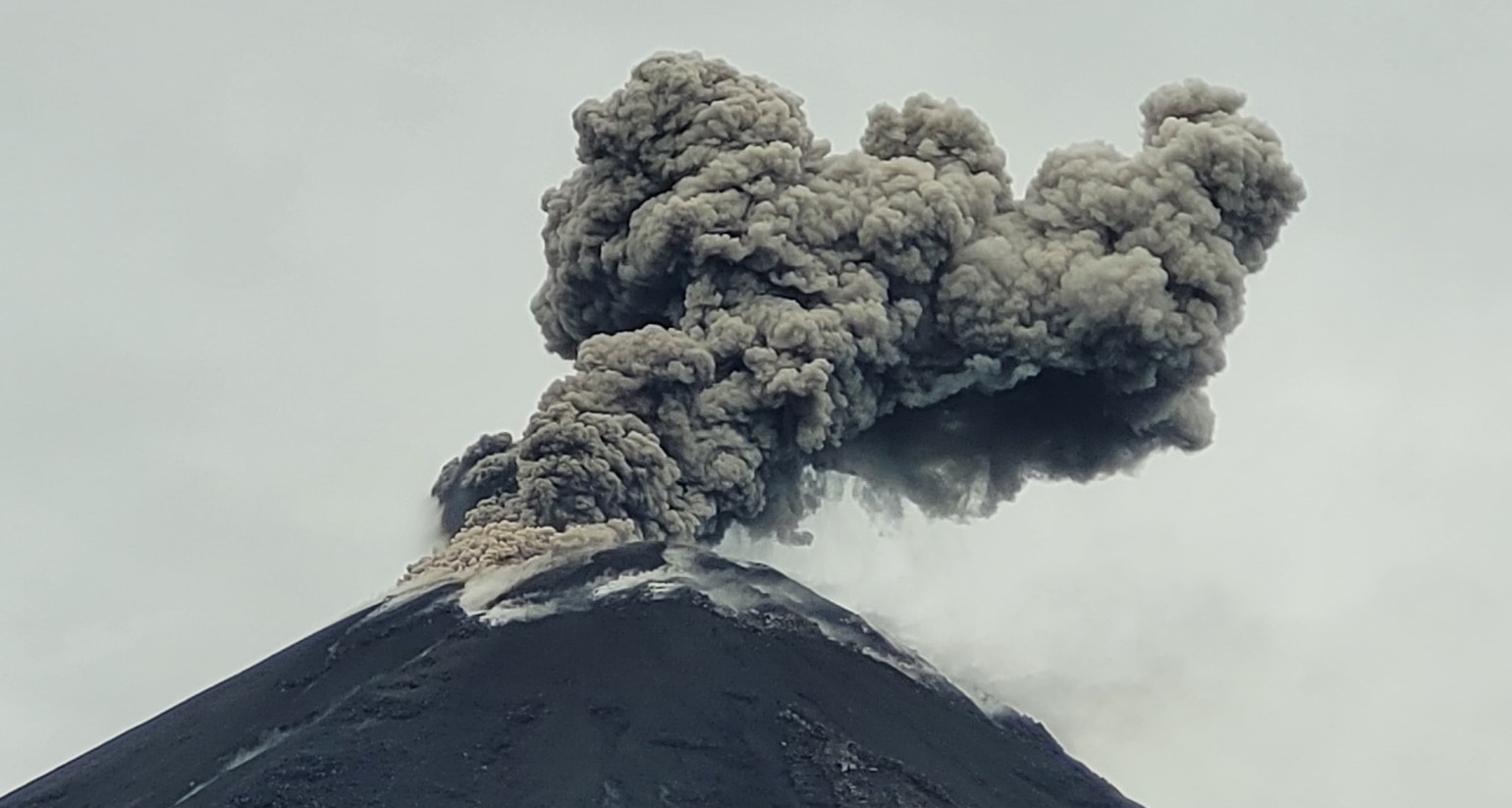
REVENTADOR VOLCANO DAILY STATE REPORT, Sunday, April 5, 2026.
Geophysical Information Institute – EPN.
Surface Activity Level: High, Surface Trend: No Change
Internal Activity Level: Moderate, Internal Trend: No Change
From April 4, 2026, 11:00 AM to April 5, 2026, 11:00 AM:
Seismicity:
Explosions (EXP): 54
Long Periods (LP): 8
Emission Tremors (TREMI): 12
Harmonic Tremors (TRARM): 20
Volcano Tectonics (VT): 2
Ash plume/emissions:
Yesterday morning, the GOES-19 satellite system detected a gas and ash plume reaching an altitude of less than 800 meters above the crater, drifting west-northwest.
This morning, another gas and ash plume was recorded, reaching an altitude of 900 meters, drifting northwest. The Washington VAAC also reported a gas and ash plume reaching an altitude of 1,000 meters, also drifting west-northwest.
Other monitoring parameters:
Over the past 24 hours, satellite systems have recorded the following thermal anomalies: FIRMS recorded 3 thermal anomalies, MIROVA-MODIS recorded 1 low-intensity thermal anomaly, MIROVA-VIIRS 375 recorded 1 low-intensity thermal anomaly, and MIROVA-VIIRS 750 recorded 1 low-intensity thermal anomaly.
Note: The volcano’s surface activity is high. The volcano has remained cloud-covered since yesterday until the time of this report.
Alert Level – SGR: Orange
Source et photo : IGEPN.
Costa Rica , Rincon de la Vieja / Turrialba :
Rincon de la Vieja:
Latitude: 10.83°N;
Longitude: 85.34°W;
Altitude: 1916 m.
Current Activity Level: Alert.
A small eruption was recorded on March 26 at 12:24 PM. The tremor varies in amplitude and frequency, generally between 1 and 5 Hz. On March 22, the tremor increased exponentially, then decreased sharply on March 25. Harmonic and gliding tremors are observed occasionally. Brief tremor pulses are occasionally observed (between March 22 and 27).
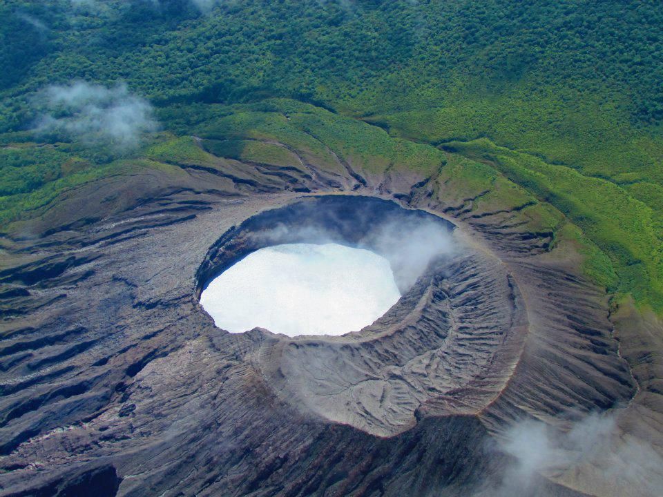
Long-period, tornillo-type events of stable amplitude continue to occur. Since the beginning of March, the dominant frequency of tornillos has increased. Six distal volcano-tectonic earthquakes were recorded this week. The geodetic network shows no significant deformation. The MultiGAS station continues to detect very low gas concentrations. This week, DOAS stations recorded an average SO₂ flux of approximately 70 t/d, with a maximum value of 180 t/d.
Turrialba:
Latitude: 10.02°N;
Longitude: 83.76°W;
Elevation: 3325 m
Current Activity Level: Alert
Seismic and volcanic activity has remained stable, with the number of long-period (LP) earthquakes not exceeding 10 per day since February 2026. A slight increase in earthquakes with tonal coda has been observed in recent days (10 events), along with a few discrete two-phase events. On March 22 at 12:03 local time, seismographs and infrasound acoustic sensors recorded a volcano-tectonic earthquake of type VT, followed one minute later by a rockfall in a sector of the volcanic edifice.
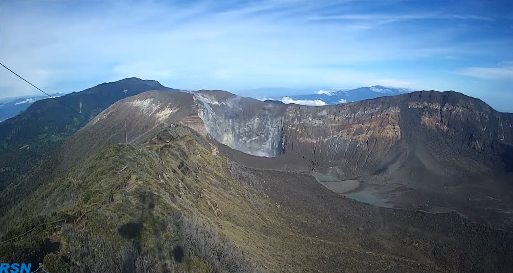
The epicenter was located approximately within the volcanic edifice, beneath the summit area. The geodetic network recorded a slight contraction of the Irazú-Turrialba massif, but no significant vertical movement was detected, except around the crater. The MultiGAS station indicates a stable gas composition, with an H₂S/SO₂ ratio close to 0.4. This week, DOAS stations recorded an average SO₂ flux of approximately 50 t/d, with a maximum value of 150 t/d. Since October 2025, the European SENTINEL satellite has detected SO₂ masses not exceeding 30 tonnes.
Source : Ovsicori
Photos : Raul Mora / RSN / UCR , RSN.