March 31 , 2026.
La Réunion Island , Piton de la Fournaise :
Press release from the Paris Institute of Earth Physics / Piton de la Fournaise Volcanological Observatory, March 31, 2026 – 8:30 a.m. local time – 4:30 a.m. UTC
Eruption in progress
Summary
The eruption that began on February 13, 2026, resumed on March 28 at approximately 3:00 p.m. local time. Only one eruptive site is active on the south-southeast flank, at the cone formed between February 13 and March 25. Only the main southeast flow is being replenished. Lava tube activity is well-developed with numerous resurgences. At the eruptive cone,
lava surges and overflows are observed. The eruptive tremor (an indicator of lava and gas flow) has been stable over the last 24 hours.
Observations at the various sites
After a pause observed between March 25 (4:30 PM local time) and March 28, the eruption that began on February 13, 2026, on the south-southeast flank of the volcano resumed on March 28 around 3:00 PM local time. The eruptive site remains on the south-southeast flank of the volcano at an altitude of 2056 m, at the cone formed between February 13 and March 25.
At the eruptive cone, the lava level is high, with active eddies and recurring lava overflows associated with the rising of gas bubbles.
Lava tunnel activity continues downstream of the cone, with numerous resurgences visible in the lava field formed between February 13 and March 25, 2026. These resurgences are clearly visible in the Grandes Pentes area. Only the southern arm of the lava field is currently active. One of these resurgences was feeding a very active lava flow at the road crossing in the early evening of March 30th, a flow heading towards the platform.
Following the weak resurgences observed yesterday morning at the point where the platform meets the ocean, no other activity was observed on the platform during the day of March 30th. Furthermore, no active underwater lava flow was observed around 10:00 AM local time on March 30th during a dive by the BIOLAVE team.
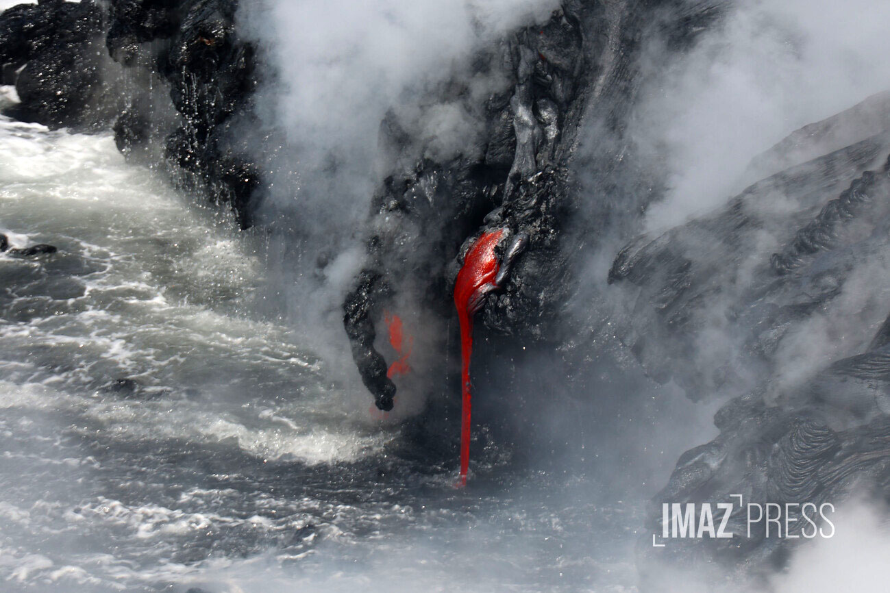
Despite the platform’s low or nonexistent current supply of lava, a small plume of gas is still present at the point where the lava enters the ocean, and its intensity depends on the amount of lava reaching the ocean. This plume is primarily composed of water vapor, hydrochloric acid (HCl), and fine particles. When the lava, at a temperature of approximately 1130°C, comes into contact with ocean water rich in sodium chloride, it generates an acidic aerosol in the form of fine suspended droplets. This plume also contains particles of pulverized lava and fragments of volcanic glass, which can be transported over several hundred meters to kilometers by the wind.
Explosions could also occur if the platform becomes destabilized. Indeed, this platform, composed of an accumulation of lava flows and rock fragments, remains highly unstable and fragile. In the event of sudden destabilization, explosions of varying intensity could occur.
Instrumental Observations
Over the past 24 hours, seismicity has increased slightly, with 14 shallow volcano-tectonic earthquakes (above sea level). These earthquakes were located in the summit area of the volcano.
Inflation, indicating the pressurization of the shallow magma reservoir (located approximately 1.5-2 km below the summit area), appears to have ceased. This parameter will need to be confirmed in the coming days.
The intensity of the eruptive tremor (an indicator of lava and gas flow) has decreased slightly since 4:00 PM local time on March 30 (12:00 UTC).
Surface flow rates, estimated from satellite data via the HOTVOLC platform (OPGC – Clermont Auvergne University), increased slightly at the end of the day yesterday, with average values of 10 m³/s and a peak of 17 m³/s. It should be noted that these estimates can vary significantly depending on cloud cover and become zero in the event of total cloud cover. Current lava tube activity also tends to underestimate the flow rates observed by satellite.
Alert Level 2.2
Source : OVPF / IPGP.
Photo : Nicolas Villeneuve/www.imazpress.com
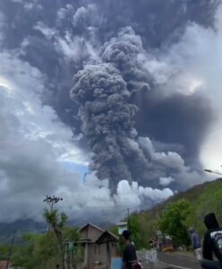
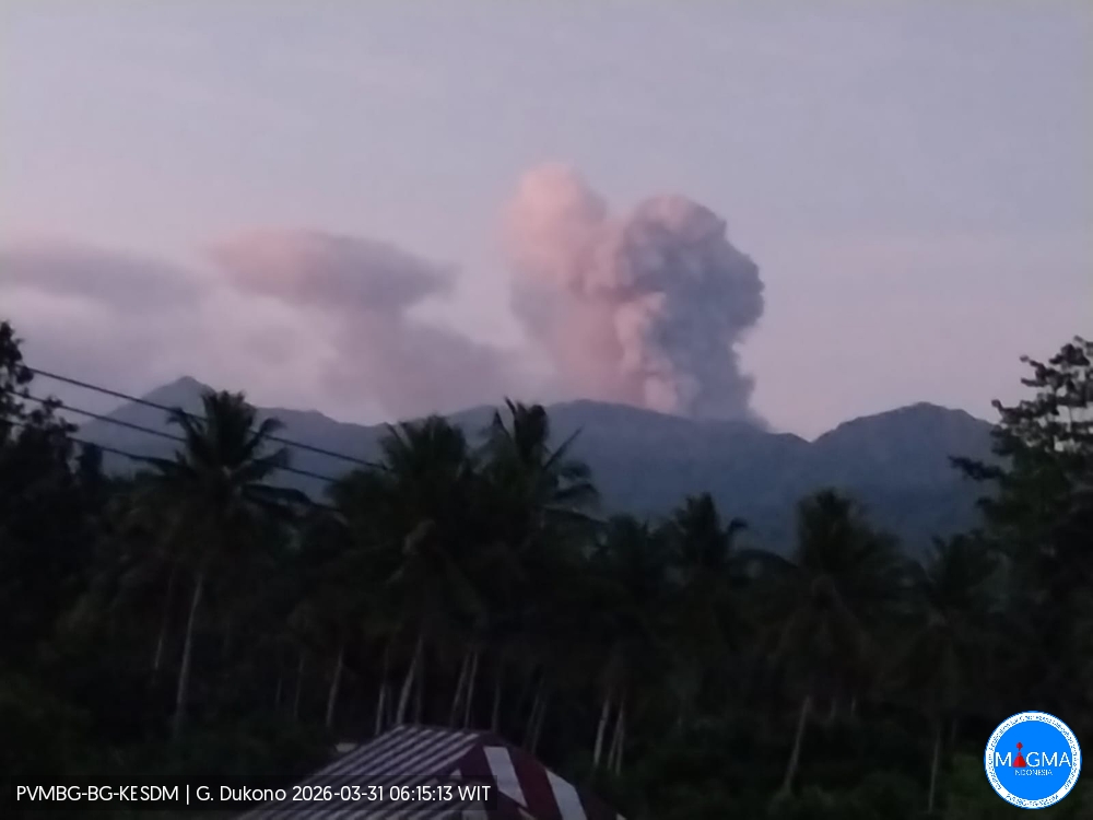
Indonesia , Dukono :
Mount Dukono experienced an eruption on Tuesday, March 31, 2026 at 06:06 WIT. An ash column was observed approximately 800 meters above the summit (at an altitude of about 1,887 meters). This ash column, white to gray in color, was highly concentrated and drifted eastward. At the time of writing, the eruption was still ongoing.
Seismic Observations
199 eruption earthquakes with amplitudes ranging from 5 to 29 mm and durations ranging from 30.4 to 102.73 seconds.
One deep volcanic earthquake with an amplitude of 9 mm and a duration of 22.31 seconds.
Five local tectonic earthquakes with amplitudes ranging from 7 to 20 mm and durations ranging from 34.6 to 54.04 seconds.
One distant tectonic earthquake with an amplitude of 13 mm and a duration of 96.59 seconds.
Continuous seismic tremor with an amplitude between 1 and 5 mm, predominantly 3 mm.
Recommendations
(1) Communities living near Mount Dukono and visitors/tourists are advised to refrain from any activity, climbing, or approaching the Malupang Warirang crater within a 4 km radius.
(2) Since volcanic ash eruptions are periodic and the dispersion of ash depends on the direction and strength of the wind, and the coverage area is not constant, communities living near Mount Dukono are advised to always have masks/face coverings available to protect themselves from the respiratory risks associated with volcanic ash.
Source et photo : PVMBG.
Colombia , Galeras :
San Juan de Pasto, March 24, 2026, 4:10 PM
Regarding the monitoring of activity at the Galeras volcano, the Colombian Geological Survey (SGC), an agency under the Ministry of Mines and Energy, reports the following:
For the period from March 17 to 23, 2026, the main variations in monitored parameters compared to the previous week were as follows:
● In a context of low volcanic activity, a slight decrease in seismic frequency and an increase in energy released were observed. Seismicity associated with rock fracturing within the volcanic edifice remained predominant, followed by events related to fluid movement.
● Fracture seismicity was dispersed within a radius of less than 10 km around the crater and at depths between 0.5 and 12 km from the summit (4,200 m altitude). The earthquake of March 18 at 8:25 p.m., with a magnitude of 2.7 and a depth of 5.9 km, is noteworthy. It was felt by the residents of Pasto.
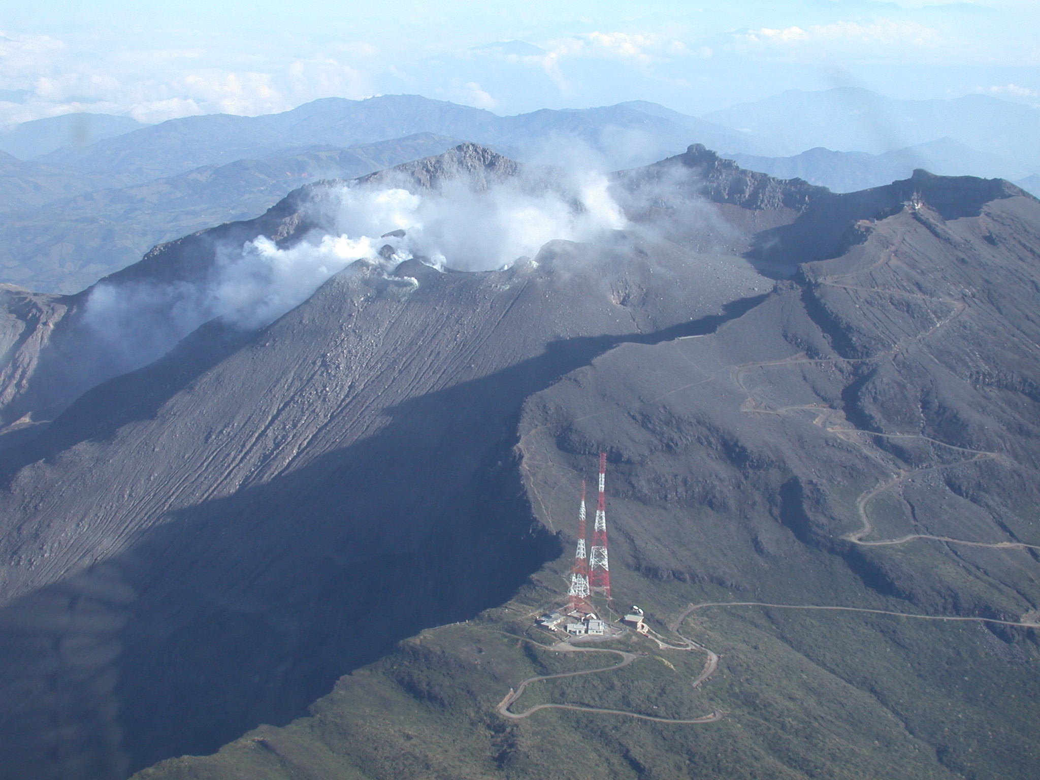
● Thanks to favorable atmospheric conditions, low-altitude plumes of white gas were identified. Their dispersion was variable, and their origin was primarily located in the fumarole fields of El Paisita (northern flank) and Las Chavas (western flank).
● Other volcanic monitoring parameters remained stable.
In light of the above, the Geological Survey of Colombia (SGC) recommends closely monitoring the evolving situation by consulting the weekly bulletins and other information published through its official channels, as well as the instructions of local and departmental authorities and the National Unit for Disaster Risk Management (UNGRD).
Volcanic activity remains at the yellow alert level: active volcano with changes in the baseline behavior of monitored parameters and other manifestations.
Source et photo : SGC.
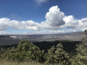
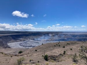
Hawaii , Kilauea :
HAWAIIAN VOLCANO OBSERVATORY DAILY UPDATE , U.S. Geological Survey
Monday, March 30, 2026, 8:21 AM HST (Monday, March 30, 2026, 18:21 UTC)
19°25’16 » N 155°17’13 » W,
Summit Elevation 4091 ft (1247 m)
Current Volcano Alert Level: WATCH
Current Aviation Color Code: ORANGE
Activity Summary:
The Halemaʻumaʻu eruption of Kīlauea is paused. The summit is currently inflating, and glow was visible from both vents overnight. The current forecast window for episode 44 is April 6-14.
No significant activity has been noted along Kīlauea’s East Rift Zone or Southwest Rift Zone.
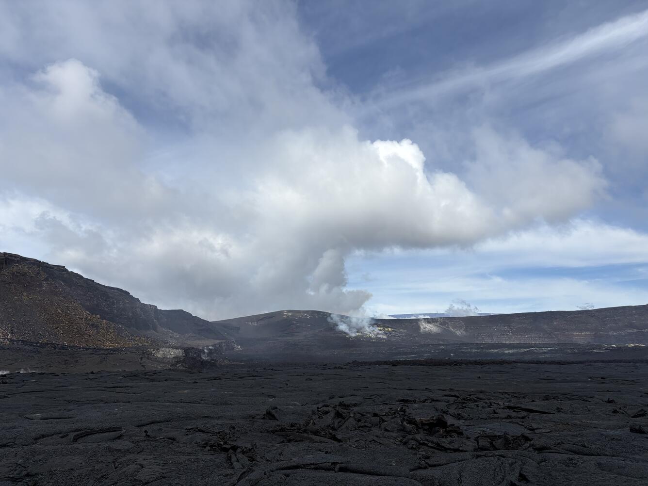
This photograph was taken from the eastern part of the crater floor of Halemaʻumaʻu on March 25, 2026, after episode 43 of lava fountaining that occurred in this area on March 10, 2026. The north and south vents are visible with yellow sulfur crystals decorating its surface. The impressive hill of tephra that has been progressively getting higher with each episode is visible above and behind these vents.
Summit Observations:
Moderate glow from the south vent and strong continuous glow from the north vent was observed overnight. Currently, both vents are emitting gas plumes.
Seismic tremor is continuous with no bursts. No earthquakes were recorded at the summit during the past day.
Summit tiltmeters UWD and SMC continue to record inflation since the end of episode 43. The UWD tiltmeter has recorded an estimated 19.5 microradians of inflationary tilt since the end of episode 43. This is a gain of 0.7 microradians in the last 24 hours.
During eruptive pauses, like the current conditions, the SO2 emission rate from the summit has varied within a typical range of 1,000 to 5,000 tonnes of SO2 per day.
Rift Zone Observations:
Rates of seismicity and ground deformation remain low in the East Rift Zone and Southwest Rift Zone. SO2 emissions from the East Rift Zone remain below the detection limit.
Source : HVO.
Photo : USGS / D. Downs.
Ecuador , El Reventador :
REVENTADOR VOLCANO DAILY STATE REPORT, Monday, March 30, 2026.
Geophysical Information Institute – EPN.
Surface Activity Level: High, Surface Trend: No Change
Internal Activity Level: Moderate, Internal Trend: No Change
From March 29, 2026, 11:00 AM to March 30, 2026, 11:00 AM:
Seismicity:
Explosive (EXP) 86
Long Period (LP) 8
Emission Tremor (TREMI) 6
Harmonic Tremor (TRARM) 4

Rainfall / Lahars:
No precipitation has been recorded in the volcano area over the past 24 hours. **In the event of heavy rainfall, accumulated material could be remobilized, generating mudflows and debris flows that would cascade down the volcano’s flanks and into nearby rivers.**
Emission Column / Ash:
Early this morning, the GOES-19 satellite system detected a plume of gas and ash moving northwest, reaching an altitude of 1,000 meters above the crater. The Washington VAAC issued a report regarding this activity, noting a plume of gas and ash reaching an altitude of 1,000 meters above the crater and moving northwest.
Note:
Since yesterday afternoon, the area around the volcano has remained cloudy, as indicated by satellite observations.
Alert level – SGR: Orange
Source et photo : IGEPN.