March 21 , 2026 .
La Réunion Island , Piton de la Fournaise :
Press release from the Paris Institute of Earth Physics / Piton de la Fournaise Volcanological Observatory, March 21, 2026 – 7:45 a.m. local time – 3:45 a.m. UTC
Eruption in progress
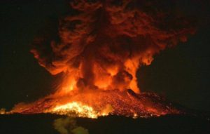
The eruption that began on February 13, 2026, shortly after 10:00 a.m. (local time) at Piton de la Fournaise continues.
Only one eruptive site remains active on the south-southeast flank of the volcano at an altitude of 2,056 meters, with a cone that has formed from the accumulation of ejected material. Lava fountain activity has resumed at the eruptive site, with ejections reaching about ten meters above the cone, visible from Piton de Bert.
The lava field emitted from the eruptive site still forms two main arms. Since March 18, the northern arm has been fed again by a flow that was located at the bottom of the Grandes Pentes. Drone surveys conducted yesterday morning at 9:10 AM indicated that the active front of this lava flow was located approximately 2.8 km from National Route 2 (RN2), at an altitude of 690 m. This lava flow arm is now stable and does not appear to have advanced significantly overnight.
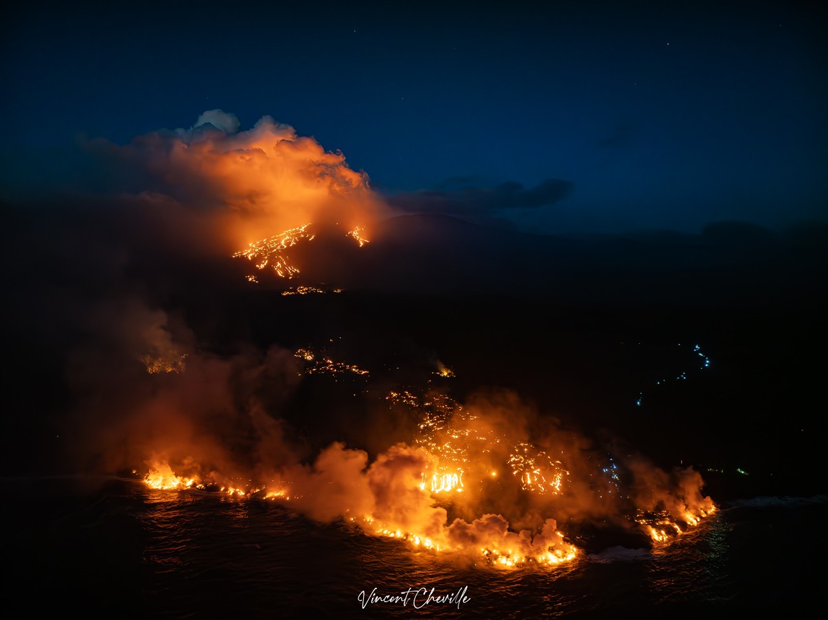
The southern arm, after splitting into several secondary branches, crossed the RN2 highway on March 13th and reached the ocean on March 16th. Upstream of the road, several resurgences and secondary flow branches are visible, including one flow branch south of the main arm. During the night of March 20th-21st, 2026, the fronts of these branches appeared to be frozen, with activity concentrated in the upstream part of the flow.
Several secondary branches also formed downstream of the RN2 before the flow reached the ocean. At the point of contact between the lava and the ocean, a platform continues to build and widen, resulting from the accumulation of lava flow and fine particles from lava fragmentation. Observations made by the OVPF teams on March 20 indicate that the platform has advanced approximately 142 m towards the ocean (maximum extent) over a width of ~840 m along the pre-existing coastline, for a total estimated surface area of ~37,000 m² (3.7 ha). These estimates remain to be confirmed, as drone observations are sometimes obscured by the plume associated with the lava flow entering the sea. The platform’s formation is being fueled by both the main flow and a secondary branch at the platform’s southern end.
A plume is still present at this point of entry into the ocean. This plume is primarily composed of water vapor, hydrochloric acid (HCl), and fine particles. When lava, at a temperature of approximately 1130°C, comes into contact with ocean water rich in sodium chloride, it generates an acidic aerosol in the form of fine suspended droplets. This plume also contains particles of pulverized lava and fragments of volcanic glass, which can be transported over several hundred meters to kilometers by the wind.

This plume, sometimes called « lava haze, » can be irritating and corrosive to the respiratory tract, skin, and eyes. Its dispersion is highly dependent on local weather conditions. Furthermore, the sudden contact between lava and water can generate localized explosions, projecting molten material and jets of high-temperature steam in the immediate vicinity of the point of entry into the sea. Explosions could also occur if the platform becomes destabilized. Indeed, this platform, composed of an accumulation of lava flows and rock fragments, remains very unstable and fragile. In the event of sudden destabilization, explosions of varying intensity could occur. In addition, lava flows have developed in tunnels within the platform. On the surface of the hardened areas, the temperature remains high, exceeding 100°C.
The increase in seismic activity is now well marked, with more than 180 volcano-tectonic earthquakes detected on March 20 (Figure 6). These earthquakes are located above the shallow reservoir and mostly below the southeastern rim of the Dolomieu crater.
Deflation of the summit area is also now well marked. For several days, the baselines crossing the summit showed stabilization; now a decrease in these baselines is being recorded, indicating a contraction of the summit area. The initiation of deflation suggests a depressurization of the shallow magma reservoir.
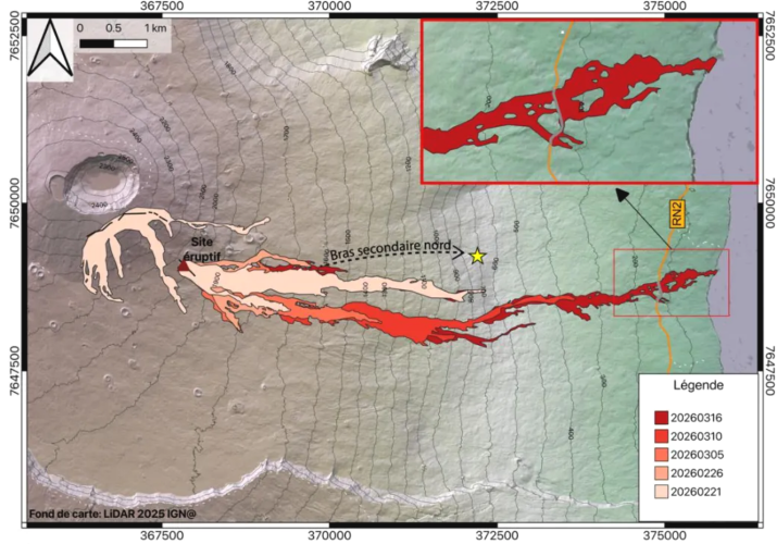
Evolution of the lava field. The outlines were estimated from Sentinel-1, Sentinel-2, and Planet images up to March 16 (see press release of March 18, 2026). The advance of the northern secondary arm is shown by a black dashed arrow, and the position of the front at 9:10 a.m. on March 20 is indicated by a star. Eruptive fissures are represented in black, and the current eruptive site by a triangle (© OI²/ISDeform – OSUL, OPGP-LMV, University of Reunion Island, OVPF-IPGP).
Since March 14, a significant increase in eruptive tremor has been observed, accompanied by intermittent « gas piston » phases. These signals indicate pulsed degassing in the conduit, linked to the ascent of gas pockets through the magma approximately every 5 to 10 minutes. On the surface, this intermittent degassing manifests as alternating periods of lava fountain activity followed by calmer phases without visible ejections. These gas piston phases are themselves intermittent, with sequences of stopping and resuming activity. The last such sequence ended on March 20 around 7:30 UTC (11:30 local time) and was followed by a slight decrease in the tremor amplitude.
The intensification of the tremor is correlated with an increase in SO₂ fluxes measured by satellite (TROPOMI) and by the OVPF’s NOVAC ground-based network since March 15, suggesting an increase in degassing activity. Since March 18, an increase in estimated flow rates using satellite data (HOTVOLC, OPGC-Université Clermont Auvergne and MIROVA, University of Turin) has also been observed, with peak values exceeding 30 m³/s reached on March 20.
Note that these values may be underestimated due to observational biases, particularly those related to weather conditions (cloud cover), the development of lava flows in tunnels, and the entry of the lava flow into the sea, which limit the detection of thermal radiation.
Alert Level 2.2
Source : OVPF / IPGP.
Photos : Vincent Cheville / Vincent Tunneldelave Réunion / FB , OVPF.
Indonesia , Semeru :
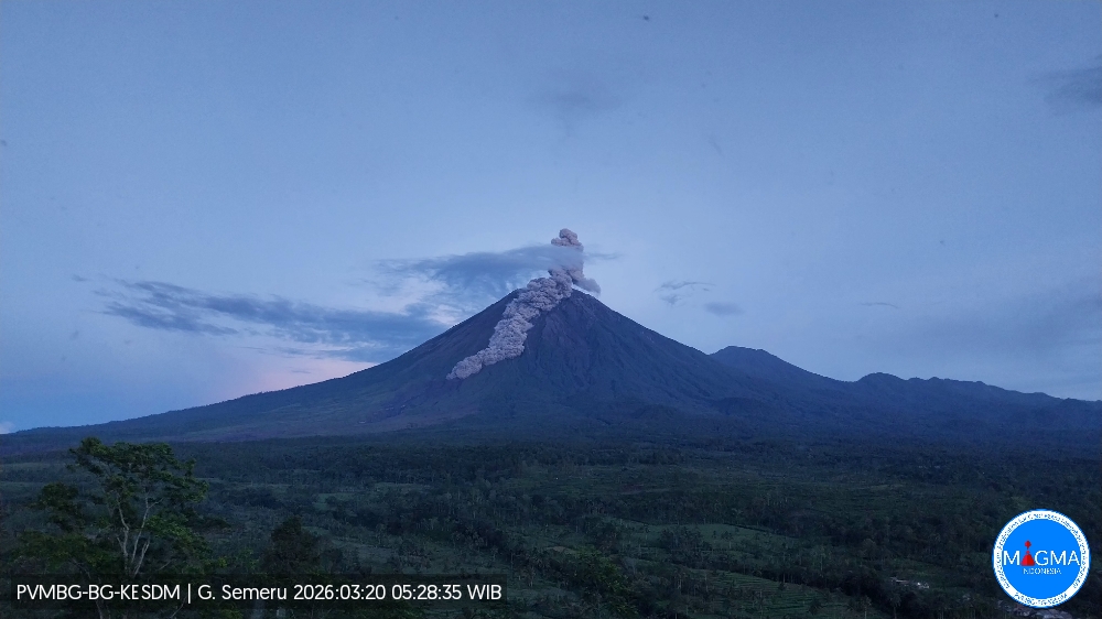
Mount Semeru experienced an eruption on Friday, March 20, 2026 at 5:26 AM WIB. An ash column was observed approximately 1,000 meters above the summit (at an altitude of about 4,676 meters). This ash column was gray and dense, drifting northeast. At the time of writing, the eruption was still ongoing.
VOLCANO OBSERVATORY NOTICE FOR AVIATION – VONA
Issued : March 20 , 2026
Volcano : Semeru (263300)
Current Aviation Colour Code : ORANGE
Previous Aviation Colour Code : orange
Source : Semeru Volcano Observatory
Notice Number : 2026SMR567
Volcano Location : S 08 deg 06 min 29 sec E 112 deg 55 min 12 sec
Area : East java, Indonesia
Summit Elevation : 11763 FT (3676 M)
Volcanic Activity Summary :
Eruption with volcanic ash cloud at 22h26 UTC (05h26 local).
Volcanic Cloud Height :
Best estimate of ash-cloud top is around 14963 FT (4676 M) above sea level or 3200 FT (1000 M) above summit. May be higher than what can be observed clearly. Source of height data: ground observer.
Other Volcanic Cloud Information :
Ash cloud moving from north to northeast. Volcanic ash is observed to be gray. The intensity of volcanic ash is observed to be thick.
Remarks :
Eruption recorded on seismogram with maximum amplitude 22 mm and maximum duration 347 second. Eruption with pyroclastic flow
Source et photo : PVMBG.
Chile , Lascar :
For the period under review, the trend toward high values has continued since the change in alert level, despite a decrease in the number of volcano-tectonic (VT) events related to rock fracturing within the volcano. Energy levels, meanwhile, were slightly lower than in the previous period. The most energetic event, with a local magnitude (Ml) of 1.7, occurred 1.2 km south-southwest (SSW) of the volcanic edifice, at a depth of 1.8 km. Long-period (LP) events, associated with fluid dynamics within the volcano, increased in number; however, the recorded energy remained similar to that of the previous month. The reduced displacement (DR) of the most energetic event was 9.0 cm². In addition, 13 tremor-type seismic events (TR), linked to sustained fluid dynamics, were also recorded, with a maximum decay rate (DR) of 12.0 cm².
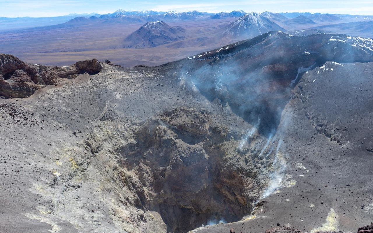
Continuous whitish plumes of degassing from the active crater were recorded by the volcano’s monitoring cameras. Their size varied, reaching a maximum height of 760 m above the crater rim on March 13. Nine sulfur dioxide (SO₂) anomalies were detected in the atmosphere, according to data from the German Aerospace Center’s (DLR) Earth Observation Center (EOC), with a maximum of 153 tons emitted on March 3. Analysis of short- and long-period radar interferometry (InSAR) data from Sentinel-1 images revealed no deformation near the volcano. During the study period, Sentinel-2 L2A images recorded areas of anomalous thermal radiation distributed throughout the volcano’s crater, covering an area of approximately 1,800 m², according to information obtained via the NHI Tools web application.
An increase in the frequency and intensity of thermal anomalies was also recorded by the MODIS sensor on the MIROVA platform, with a maximum radiative power of 2.9 MW on March 11. The use of satellite imagery (Planetscope, Sentinel-2, SkySat Collect) made it possible to identify outgassing points, but without revealing any significant morphological variations.
Source : Segemar.
Photo : Vulcanopro.
Colombia , Nevado del Ruiz :
Manizales, March 17, 2026, 7:35 PM
Regarding the monitoring of activity at the Nevado del Ruiz volcano, the Colombian Geological Survey (SGC), an agency under the Ministry of Mines and Energy, reports the following:
During the week of March 10-16, 2026, the volcano continued to exhibit unstable behavior. Compared to the previous week, the main variations observed for some monitored parameters are as follows:
– Seismicity related to fluid dynamics in volcanic conduits remained stable in terms of the number of recorded earthquakes, but the seismic energy released decreased. Long-duration seismic signals continued to be recorded during the week, with lower energy levels compared to the previous period. Surveillance cameras (conventional or thermographic) have not confirmed any pulsatile ash emission or any apparent temperature variation of the emitted materials, in connection with seismic signals.
Seismic activity associated with rock fracturing processes within the volcanic edifice maintained similar levels in terms of the number of recorded earthquakes and the seismic energy released. The earthquakes were primarily located north and northwest of the Arenas crater, at distances of 4 to 5 km, as well as within the crater itself. To a lesser extent, earthquakes were recorded sporadically on the other flanks of the volcano, up to 11 km from the crater. The depth of the earthquakes varied: up to 2 km inside the crater and between 2 and 8 km from the reference level. The recorded events exhibited low energy levels, with magnitudes less than 1.
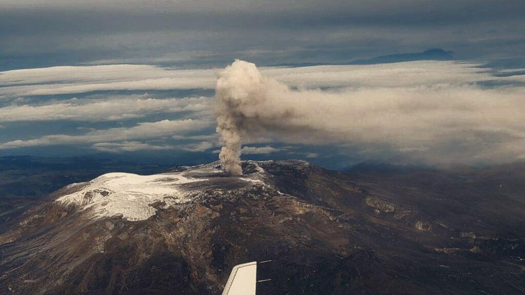
The volcano continued to emit water vapor and volcanic gases, primarily sulfur dioxide (SO₂), into the atmosphere from the Arenas crater. The estimated SO₂ flux, associated with degassing processes, remained variable, with low values, and decreased compared to the previous week. This decrease is partly attributed to wind direction, which was blowing primarily toward the volcano’s eastern flank, where monitoring station coverage is less extensive. Additional monitoring, using satellite data, also revealed low levels of SO₂ emissions.
– The height of the gas and water vapor column remained below 400 m above the volcano’s summit. The dispersion direction of this column was variable, mainly toward the volcano’s east-southeast and southeast flanks.
– Monitoring of thermal anomalies at the bottom of the Arenas crater, using satellite platforms, revealed that energy levels remained low.
Source : SGC.
Photo : via Vulcaniya / FB.
Costa Rica , Poas :
Latitude: 10.20°N
Longitude: 84.23°W
Altitude: 2687 m
Current Activity Level: Alert
This week, the amplitude of seismic activity has remained relatively stable. The number of long-period events increased at the beginning of the week, reaching its highest level of the past year, before decreasing in recent days. Some events exhibit significant amplitudes. On March 17, a sequence of brief, low-amplitude tremors was recorded. The geodetic network is not recording any significant deformation. The MultiGAS station recorded weekly averages of SO₂/CO₂ of approximately 1.1 ± 0.3 and H₂S/SO₂ of 0.3 ± 0.7, values similar to those of the previous week.
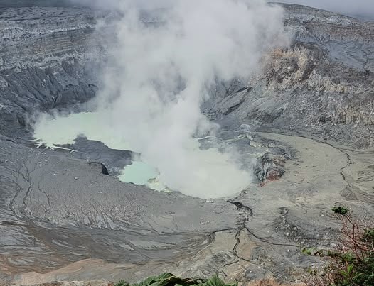
At the observation point, SO₂ concentrations as high as 4.8 ppm were recorded. DOAS stations detected a sulfur dioxide (SO₂) flux of 102 ± 68 t/d, slightly similar to that of the previous week (106 ± 18 t/d). With almost no rain this week, the level of the hyperacidic lake dropped by about 0.5 m. SO₂ was detected in the atmosphere by satellite on several occasions this week, peaking on March 16 at a mass of 60 tonnes.
Source : Ovsicori .
Photo : Sergio Lucena