March 17 , 2026.
La Réunion Island , Piton de la Fournaise :
Press release from the Paris Institute of Earth Physics / Piton de la Fournaise Volcanological Observatory, March 17, 2026 – 10:30 a.m. local time – 6:30 a.m. UTC
Eruption in progress
The eruption that began on February 13, 2026, shortly after 10:00 a.m. (local time) at Piton de la Fournaise continues.
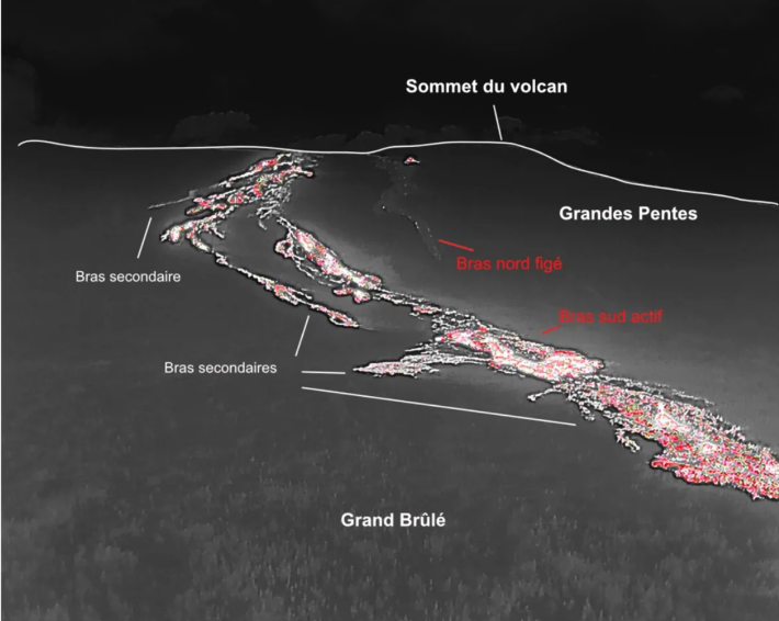
Only one eruptive site remains active on the south-southeast flank of the volcano, visible from Piton de Bert. The eruptive cone is now well-formed and continues to close progressively. Few ejecta now exceed the height of the cone. With the lateral closure of the cone, significant lava tube activity is now established. Since March 3, lava flows have been visible again in the Grandes Pentes area.
The lava field emitted from the eruptive site still forms two main arms. The northern arm of the lava flow remains stationary approximately 2.6 km from National Route 2 (RN2), at an altitude of about 660 m.
The southern arm has split into several secondary branches, which continue to advance at highly variable speeds, influenced by the topography and vegetation encountered along its path, which can locally slow or channel the lava flow.
After crossing National Route 2 (RN2) on March 13, the lava reached the ocean on March 16 at approximately 12:20 a.m. local time.
Upstream of the road, several resurgences and secondary lava flows are visible on the south side, but their advance is very slow and does not currently pose a threat to RN2.
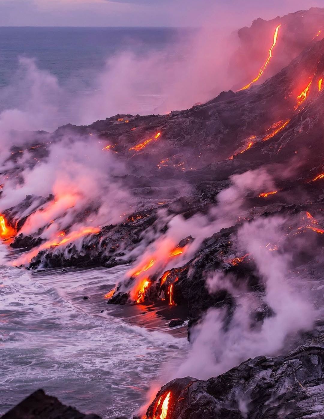
At the point of contact between the lava and the ocean, a platform is gradually forming, resulting from the accumulation of lava and its fragmentation into fine particles. Thermal readings taken yesterday, both on the ground and from the air, reveal an area approximately 600 meters in diameter where the water surface temperature exceeds 36°C.
A plume of acidic gas has also formed, primarily composed of water vapor, hydrochloric acid, and fine particles. When the lava, at a temperature of approximately 1,100°C (measured in situ on March 16 by the OVPF teams), comes into contact with the ocean, it reacts with the seawater, which is rich in sodium chloride, to form a hydrochloric acid aerosol composed of fine droplets. This mixture is also accompanied by particles of pulverized lava and sharp fragments of glass, which are then dispersed throughout the plume by the prevailing winds. This phenomenon presents another risk: the sudden contact between incandescent lava and water can cause explosions, projecting molten materials and jets of high-temperature steam.
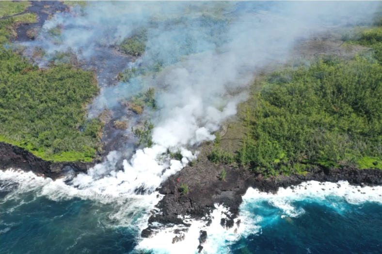
Image of lava reaching the ocean on March 16 at 10:13 a.m. local time (©OVPF-IPGP)
As in previous days, seismic activity remains low. Inflation of the volcano, visible particularly on the summit GNSS stations and at the base of the terminal cone, continues, although it has slowed in recent days. Since the end of February, baselines crossing the summit have been registering an increase in distance, indicating a gradual re-expansion of the volcano. This increase appears to have stabilized in recent days and will need to be confirmed in the coming days.
This inflation indicates pressurization of the magma supply system, possibly linked to magma recharge from the shallow reservoir, which is feeding the ongoing eruption.
Since March 14, an increase in eruptive tremor has been observed, accompanied by the appearance of intermittent « gas piston » phases, characterized by marked oscillations in the seismic signal. These phases reflect pulsed degassing in the eruptive conduit, linked to the ascent of pockets or trains of gas bubbles through the magma column, causing variations in tremor intensity and intermittent explosive bursts at the vent. In recent hours, these gas piston phases have themselves become intermittent, with sequences of stopping and restarting. Concurrently, SO₂ fluxes measured by the NOVAC network have been increasing since March 15, while lava flow rate estimates (TADR) from satellite data (HOTVOLC, OPGC – Université Clermont Auvergne and MIROVA, University of Turin) remain generally stable with values below 8 m³/s.
Thermal drone image of the Grandes Pentes and the upstream section of the RN2 highway on March 17 at 1:33 a.m. local time (©SDIS).
One possible interpretation is that of a partial gas-magma decoupling in the conduit, with a generally almost constant magma flow rate, but more efficient and pulsating degassing. The increase in tremor may also be influenced by the progressive construction of the eruptive cone, which modifies the flow and degassing conditions near the surface. However, this interpretation should be considered with caution, as satellite estimates can be biased by cloud cover, the development of lava tube flows, and the lava flow reaching the ocean, which limit the detection of thermal radiation. Similarly, SO₂ flux estimates can be affected by meteorological conditions as well as by the lava flow entering the sea, which modify the structure and dispersion of the plume.
Alert Level 2.2
Source : OVPF / IPGP.
Photos : Feno Rakoto , ,OVPF.
New Zealand , White Island :
No evidence of further ash emissions at Whakaari/White Island. Volcanic Alert Level lowered to 2 and Aviation Colour Code to Yellow.
Published: Tue Mar 17 2026 3:00 PM
Based on observations since last Thursday, no further eruptive activity has been recorded at Whakaari/White Island. The Volcanic Alert Level is lowered to 2 and the Aviation Colour Code to Yellow.
Last week Whakaari/White Island produced a minor volcanic eruption. Minor ash emissions were primarily reported via pilot reports and photos, with no major changes to the vent or eruption of rocks observed. New satellite data show that minor ash emission may have begun as early as March 8th. Observations since 12th March, including webcam imagery, satellite observations, and a gas flight yesterday have confirmed the eruptive activity has ended with no further detectable ash emissions from the volcano.
Observations from our Whakatāne and Te Kaha cameras, along with yesterday’s gas flight indicate a decrease in activity at the active vent area. Elevated volcanic gas levels were detected from the volcano during the gas flight and from satellite observations but were still lower than those measured during previous eruptive activity last year. A new thin ash deposit covers the inner crater floor around the active vent and some of the south side of the island, but no new ash was visible exiting the vent.
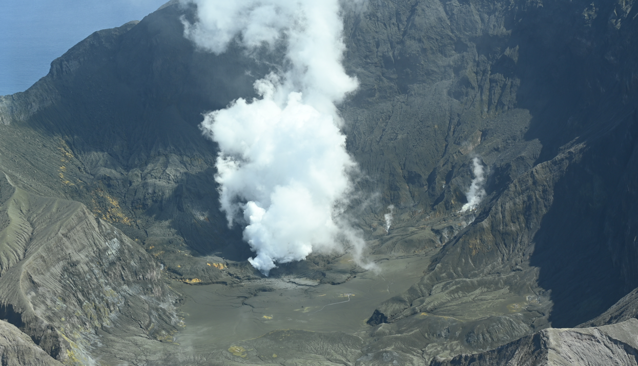
Image from gas flight on 16 March 2026, showing steam and gas plume exiting the active vent. (Photo: Karen Britten, ESNZ)
Due to no evidence for further eruptions or ash emission from Whakaari/White Island since 12th March, we have lowered the Volcanic Alert Level to 2 (moderate-heightened unrest) and Aviation Colour Code to Yellow. While eruptive activity has ceased for now, volcanic activity could re-escalate with little or no warning. Further sudden, more explosive events could therefore affect the crater floor and immediate vicinity of the island, although ashfall affecting the mainland remains unlikely.
The Earth Sciences New Zealand’s Volcano Monitoring Group and National Geohazards Monitoring Centre will continue to closely monitor Whakaari/White Island for any changes in activity. Without sensors on the island, our monitoring continues to rely on remote cameras, satellite imagery, and periodic observation and gas flights to monitor Whakaari/White Island. We will provide further updates when information becomes available.
Given our lack of real-time monitoring data from the island, we cannot distinguish between Volcanic Alert Level 1 and 2. As a result, Whakaari/White Island will remain at a minimum of Volcanic Alert Level 2 until on-island monitoring is reinstated.
Source : Geonet.
Photo : Karen Britten, ESNZ .
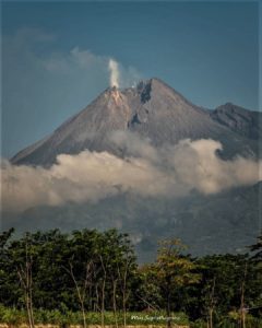
Indonesia , Ibu :
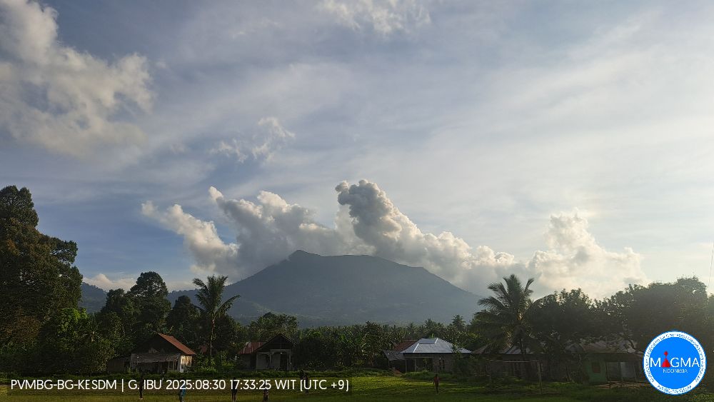
Mount Ibu experienced an eruption on Monday, March 16, 2026 at 23:07 WIT. An ash column was observed approximately 700 meters above the summit (at an altitude of about 2025 meters). This ash column, white to gray in color, was moderately to strongly intense and drifted northeast and east. The eruption was recorded by a seismograph with a maximum amplitude of 20 mm and a duration of 43 seconds.
Seismic Observations
114 eruption earthquakes with amplitudes between 15 and 28 mm and durations of 34 to 69 seconds.
12 harmonic tremors with amplitudes between 2 and 28 mm and durations of 36 to 130 seconds.
101 low-frequency earthquakes with amplitudes between 2 and 10 mm and durations of 17 to 29 seconds.
147 shallow volcanic earthquakes with amplitudes between 2 and 10 mm and durations of 7 to 21 seconds.
One deep volcanic earthquake with an amplitude of 4 mm, lasting 2 seconds and 18 seconds.
14 distant tectonic earthquakes with amplitudes between 4 and 28 mm and durations of 34 to 111 seconds.
Recommendations
1. Residents living around Mount Ibu and visitors/tourists are advised to refrain from all activities within a 2 km radius and for a distance of 3.5 km towards the crater opening in the northern part of the active Mount Ibu crater.
2. In the event of ashfall, people engaging in outdoor activities are advised to wear a mask covering their nose, mouth, and eyes, as well as protective eyewear.
Source : PVMBG.
Photo : PVMBG ( archive)
Hawaii , Kilauea :
HAWAIIAN VOLCANO OBSERVATORY DAILY UPDATE , U.S. Geological Survey
Monday, March 16, 2026, 7:53 AM HST (Monday, March 16, 2026, 17:53 UTC)
19°25’16 » N 155°17’13 » W,
Summit Elevation 4091 ft (1247 m)
Current Volcano Alert Level: WATCH
Current Aviation Color Code: ORANGE
Activity Summary:
The Halemaʻumaʻu eruption of Kīlauea is paused. The summit is currently inflating, intermittent glow was visible, and tremor continues. Preliminary models suggest the forecast window for the onset of episode 44 lava fountaining is March 30 to April 8.
No significant activity has been noted along Kīlauea’s East Rift Zone or Southwest Rift Zone.
High winds and heavy rains occurred yesterday, which impacted our monitoring network and caused an on-going outage at UWD tiltmeter. Aberrant signals are also observed during storm conditions at other data stations.
Summit Observations:
The V3 webcam had intermittent visibility overnight, during which times glow was observed mostly in the south vent, and minimally in the north vent. At this time, both vents are quiet and emitting plumes of gas when visible through the rain and clouds. Abundant steam is rising from the hot lava flows within Halemaʻumaʻu crater.
Seismic tremor continues with one or two bursts of tremor every 10-15 minutes. There was one, M1.3 earthquake recorded near the summit region during the past day, which had no effect on Kilauea volcanic activity.
The UWD tiltmeter lost connection yesterday, around 4:19 p.m. HST, due to heavy weather conditions. Prior to shutting down, the last recorded data at UWD began showing signs of slight inflation. Other tiltmeters located around the summit also show inflation with increased rates over the past 24 hours. The SDH tiltmeter, which is the next closest station to the crater vents, has measured ~1.5 microradians of inflation in the past day.
During eruptive pauses, like the current conditions, the SO2 emission rate from the summit has varied within a typical range of 1,000 to 5,000 tonnes of SO2 per day. The National Weather Service forecast for the Kīlauea summit region for today indicates winds from the southwest at 10-15 mph with gusts up to 22 mph. Following yesterday’s storm, some isolated showers might continue throughout the day.
Rift Zone Observations:
Rates of seismicity and ground deformation remain very low in the East Rift Zone and Southwest Rift Zone. SO2 emissions from the East Rift Zone remain below the detection limit.
Source et photo : HVO.
Guatemala , Fuego :
Atmospheric conditions: Clear skies
Wind: Northwest
Rainfall: 0.0 mm
Activity
During the night and early morning, weak to moderate degassing was recorded, with fumaroles reaching approximately 300 m above the crater and dispersing to the southeast. Explosive activity continued with 9 to 13 weak to moderate explosions per hour, generating ash plumes between 4,400 and 4,800 m altitude, which drifted to the south and southeast.
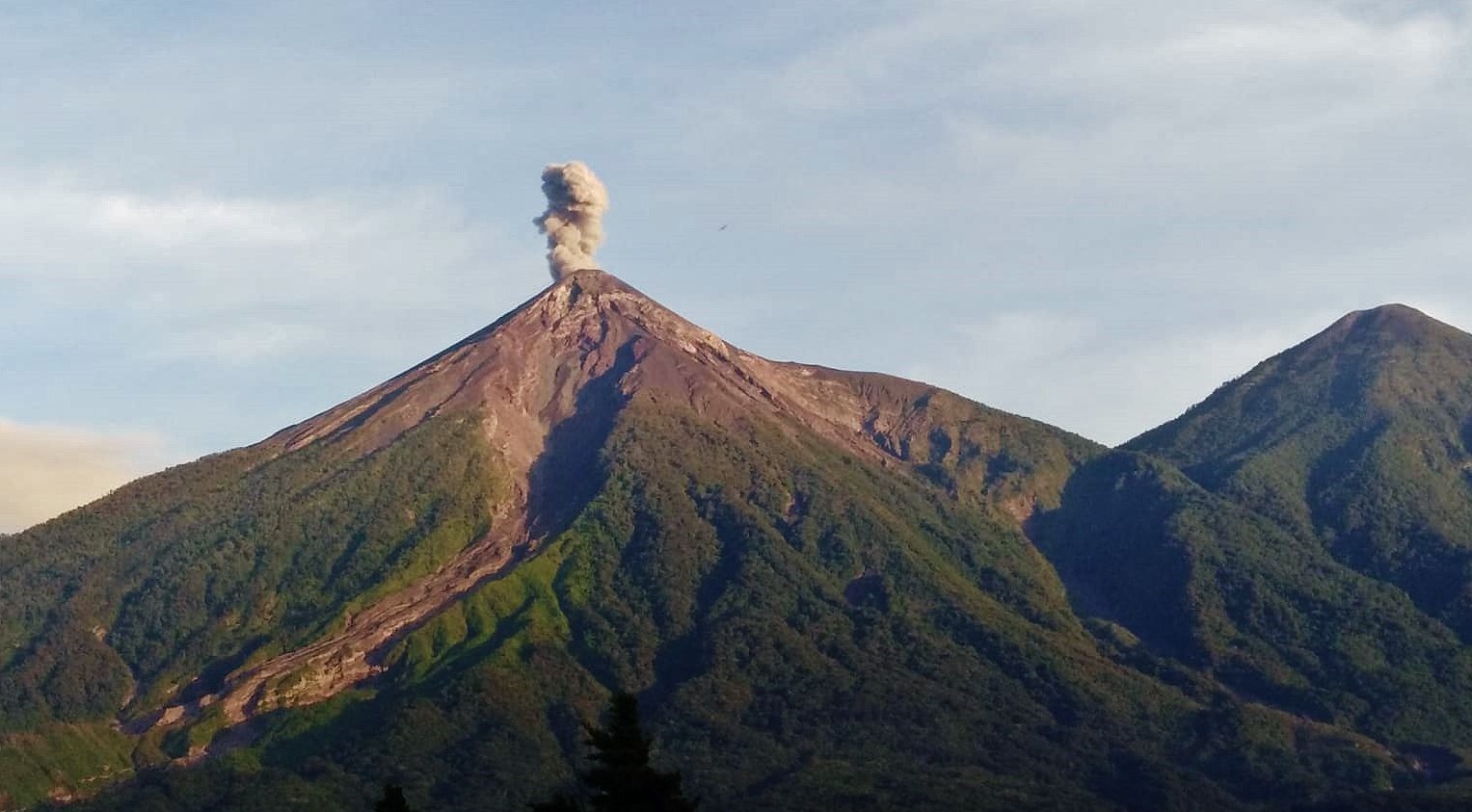
Some explosions were accompanied by rumbling sounds, shock waves, and brief noises similar to those of locomotives, associated with the continuous expulsion of gas. Incandescent pulsations reaching up to 300 m above the crater were observed, accompanied by small avalanches. In addition, incandescent material fell back around the crater, flowing towards the ravines of Ceniza, Taniluyá, Seca, Santa Teresa, Trinidad, and Las Lajas, sometimes reaching the vegetation line.
Source : Insivumeh.
Photo : conred via facebook